News
Map title
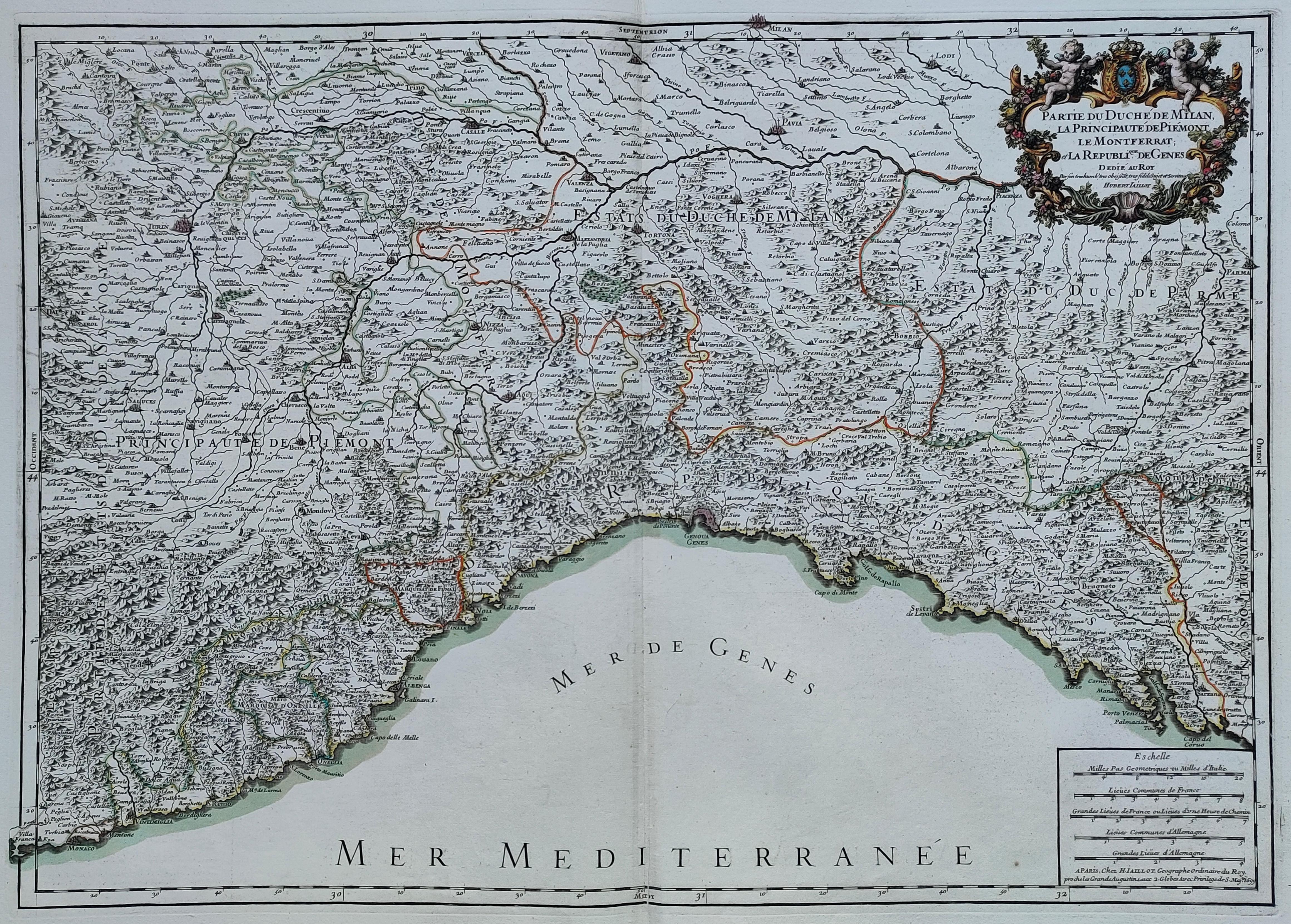
Partie du Duchè de Milan, la Principaute de Piemont le Montferrat et la Republique de Genes
Author
Alexis Hubert Jaillot
Location shown in map
Liguria
Edition date
Circa 1700
Edition place
Paris
Editor
Atlas
Atlas Geographique Contenant Les Cartes d'Espagne, de Portugal ... Tome XII
Price
350 Euro
State
[mint/EXCELLENT/very good/good/fair/mediocre/poor]
Color
Old color
Verso
Blank
Size
Plate: cm (78 x 54) inches (30.71 x 21.26) Paper: cm (66 x 47) inches (25.98 x 18.5)
Technique
Copper engraving
Note
Reference
L.Tricerri , Ligurian map catalog.
Wiki
Here for more info
In stock
Available
Info
info@thetreasuremaps.com
Code
#1278
×
![Partie du Duchè de Milan, la Principaute de Piemont le Montferrat et la Republique de Genes by Alexis Hubert Jaillot, Liguria, Circa 1700]()
Map title
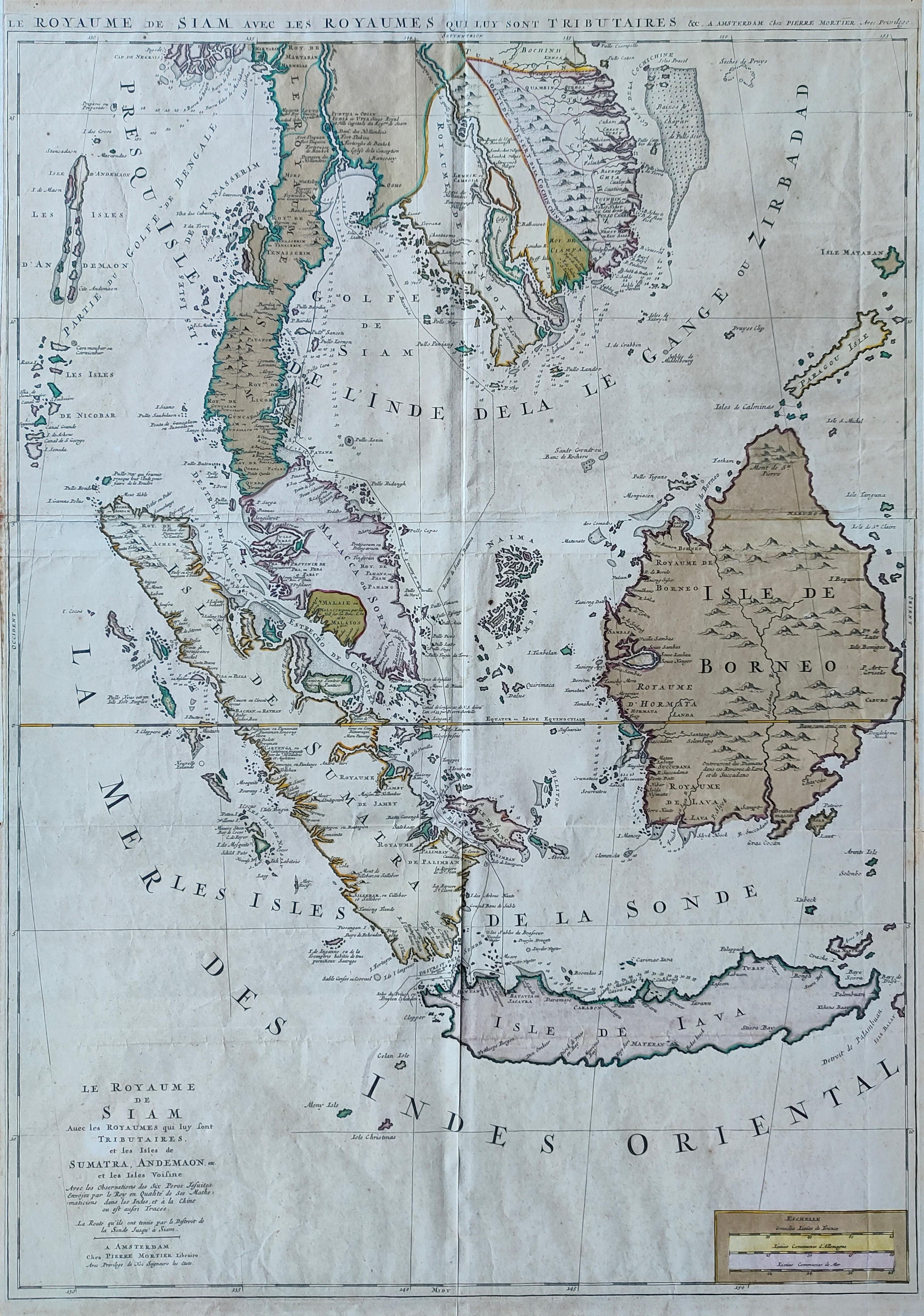
Le Royaume de Siam
Author
Mortier
Location shown in map
South East
Edition date
Circa 1700
Edition place
Amsterdam
Editor
Atlas
Price
2000 Euro
State
[mint/EXCELLENT/very good/good/fair/mediocre/poor]
Color
Old colors
Verso
Blank
Size
Plate: cm (56 x 78) inches (22.05 x 30.71) Paper: cm (57 x 81) inches (22.44 x 31.89)
Technique
Copper engraving
Note
Reference
Wiki
Here for more info
In stock
Available
Info
info@thetreasuremaps.com
Code
#1276
×
![Le Royaume de Siam by Mortier, South East, Circa 1700]()
Map title
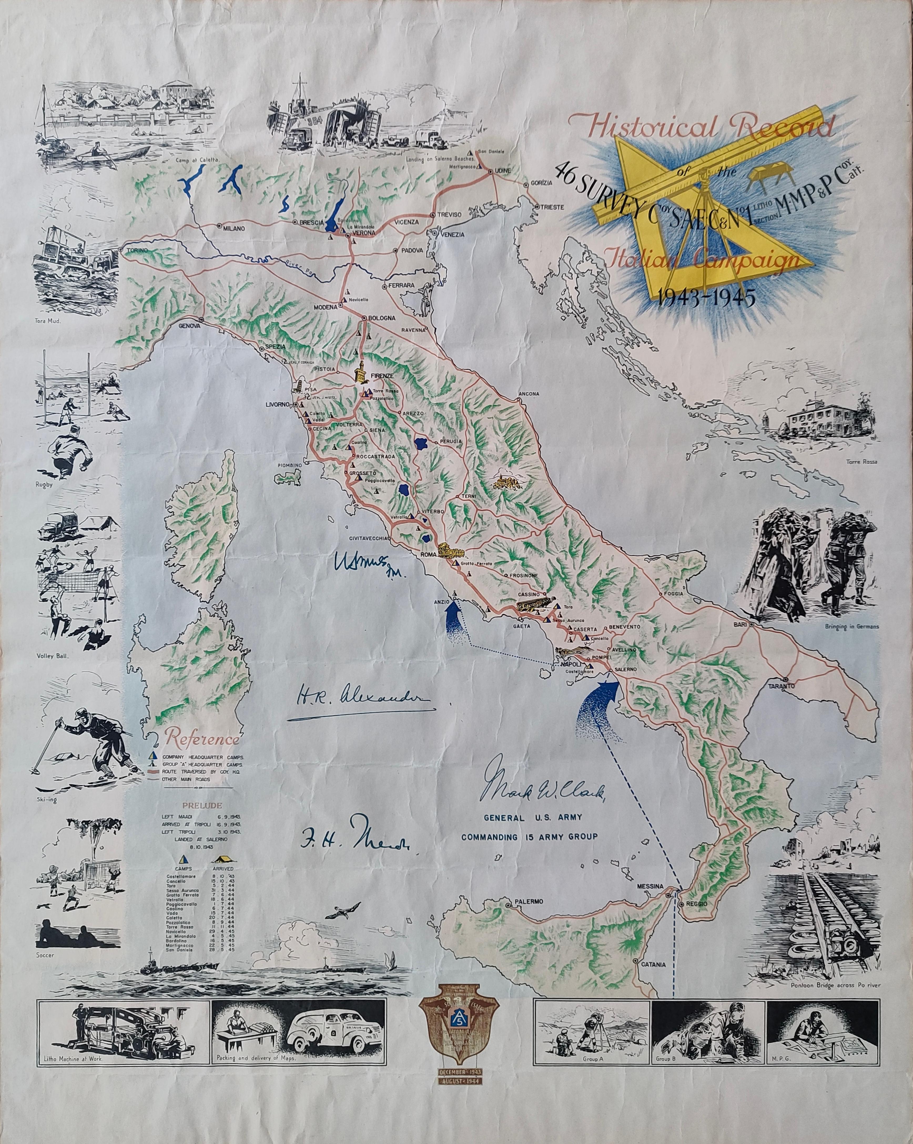
Historical record of the 46 Survey
Author
Location shown in map
Italy
Edition date
Circa 1945
Edition place
Editor
Atlas
Price
400 Euro
State
[mint/EXCELLENT/very good/good/fair/mediocre/poor]
Color
Old colors
Verso
English Text
Size
Plate: cm (50 x 62) inches (19.69 x 24.41) Paper: cm (50 x 62) inches (19.69 x 24.41)
Technique
Steel engraving
Note
Signed by General Alexander
Reference
Wiki
Here for more info
In stock
Available
Info
info@thetreasuremaps.com
Code
#1277
×
![Historical record of the 46 Survey by , Italy, Circa 1945]()
Map title
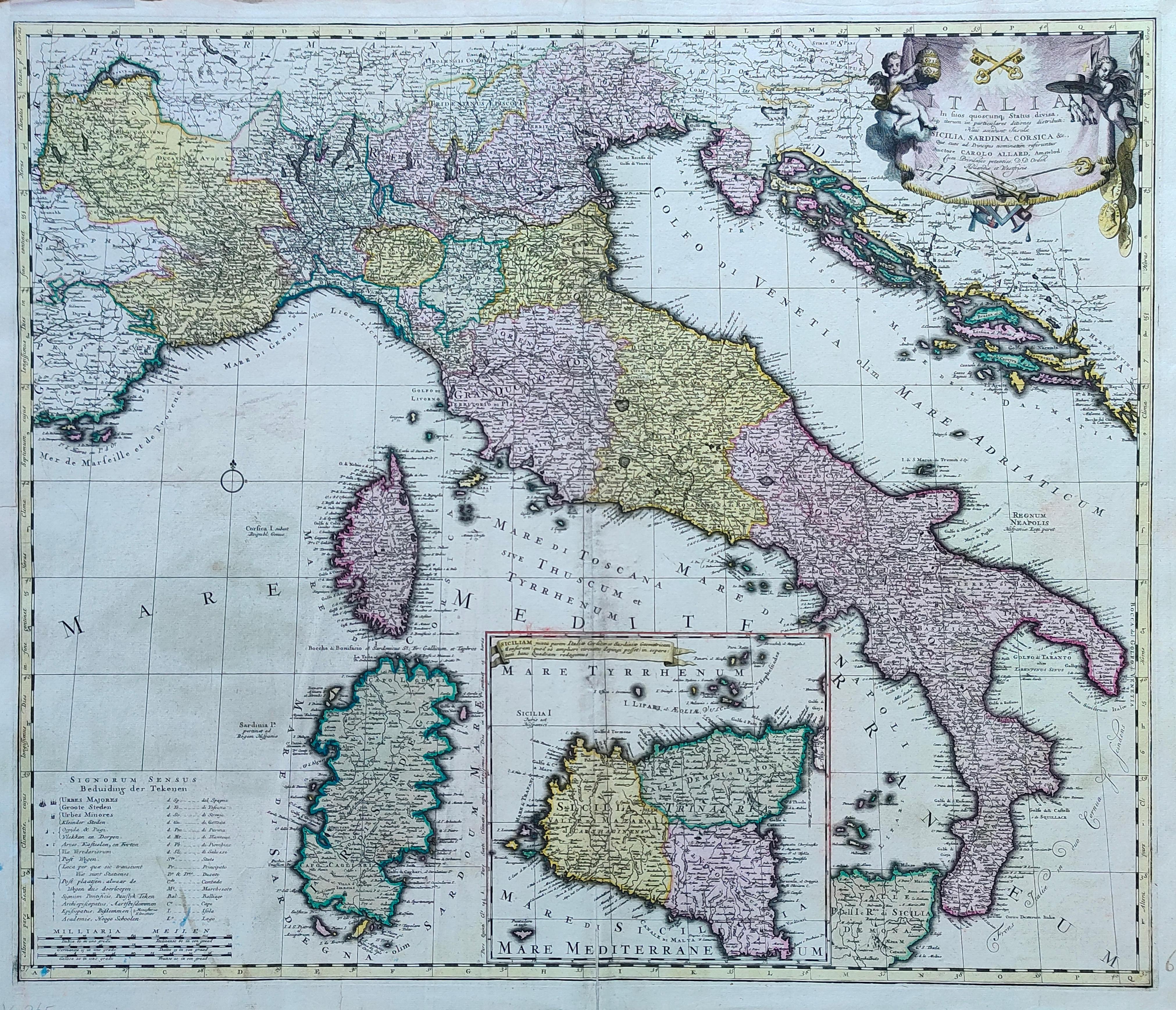
Italia in suos ...
Author
Allard
Location shown in map
Italy
Edition date
1705
Edition place
Amsterdam
Editor
--
Atlas
Atlas Major
Price
800 Euro
State
[mint/EXCELLENT/very good/good/fair/mediocre/poor]
Color
Old colors
Verso
Blank
Size
Plate: cm (59 x 50) inches (23.23 x 19.69) Paper: cm (65 x 55) inches (25.59 x 21.65)
Technique
Copper engraving
Note
Reference
R.Borri L'Italia nelle antiche carte pag.178
Wiki
Here for more info
In stock
Available
Info
info@thetreasuremaps.com
Code
#1279
×
![Italia in suos ... by Allard, Italy, 1705]()
Map title
Historical record of the 46 Survey
Author
Location shown in map
Cirenaica
Edition date
Circa 1945
Edition place
Editor
Atlas
Price
250 Euro
State
[mint/EXCELLENT/very good/good/fair/mediocre/poor]
Color
Old colors
Verso
English Text
Size
Plate: cm (60 x 47) inches (23.62 x 18.5) Paper: cm (60 x 47) inches (23.62 x 18.5)
Technique
Steel engraving
Note
Signed by General Montgomery
Reference
Wiki
Here for more info
In stock
Available
Info
info@thetreasuremaps.com
Code
#1285
×
![Historical record of the 46 Survey by , Cirenaica, Circa 1945]()

Map title
Liguria
Author
Nicouline
Location shown in map
Liguria
Edition date
Circa 1960
Edition place
Milan
Editor
Ricordi
Atlas
Price
50 Euro
State
[mint/EXCELLENT/very good/good/fair/mediocre/poor]
Color
Old colors
Verso
Blank
Size
Plate: cm (30 x 24) inches (11.81 x 9.45) Paper: cm (33 x 26) inches (12.99 x 10.24)
Technique
Steel engraving
Note
Reference
Wiki
Here for more info
In stock
Available
Info
info@thetreasuremaps.com
Code
#1305
Liguria
Author
Nicouline
Location shown in map
Liguria
Edition date
Circa 1960
Edition place
Milan
Editor
Ricordi
Atlas
Price
50 Euro
State
[mint/EXCELLENT/very good/good/fair/mediocre/poor]
Color
Old colors
Verso
Blank
Size
Plate: cm (30 x 24) inches (11.81 x 9.45) Paper: cm (33 x 26) inches (12.99 x 10.24)
Technique
Steel engraving
Note
Reference
Wiki
Here for more info
In stock
Available
Info
info@thetreasuremaps.com
Code
#1305
×
![Liguria by Nicouline, Liguria, Circa 1960]()
Map title
La grande Genova
Author
Location shown in map
Genoa
Edition date
Circa 1930
Edition place
Torino
Editor
De Agostini
Atlas
Price
50 Euro
State
[mint/excellent/VERY GOOD/good/fair/mediocre/poor]
Color
Old colors
Verso
Postcard
Size
Plate: cm (27 x 14) inches (10.63 x 5.51) Paper: cm (27 x 14) inches (10.63 x 5.51)
Technique
Steel engraving
Note
Reference
Wiki
Here for more info
In stock
Available
Info
info@thetreasuremaps.com
Code
#1304
×
![La grande Genova by , Genoa, Circa 1930]()
Map title
Liguria
Author
Nicouline
Location shown in map
Liguria
Edition date
Circa 1950
Edition place
Milan
Editor
Italgeo
Atlas
Price
75 Euro
State
[mint/EXCELLENT/very good/good/fair/mediocre/poor]
Color
Old colors
Verso
Blank
Size
Plate: cm (28 x 23) inches (11.02 x 9.06) Paper: cm (28 x 23) inches (11.02 x 9.06)
Technique
Note
Reference
Wiki
Here for more info
In stock
Available
Info
info@thetreasuremaps.com
Code
#1274
Liguria
Author
Nicouline
Location shown in map
Liguria
Edition date
Circa 1950
Edition place
Milan
Editor
Italgeo
Atlas
Price
75 Euro
State
[mint/EXCELLENT/very good/good/fair/mediocre/poor]
Color
Old colors
Verso
Blank
Size
Plate: cm (28 x 23) inches (11.02 x 9.06) Paper: cm (28 x 23) inches (11.02 x 9.06)
Technique
Note
Reference
Wiki
Here for more info
In stock
Available
Info
info@thetreasuremaps.com
Code
#1274
×
![Liguria by Nicouline, Liguria, Circa 1950]()
Map title
Parte orientale della China
Author
Coronelli
Location shown in map
China
Edition date
Circa 1692
Edition place
Venice
Editor
Atlas
Corso geografico universale
Price
2000 Euro
State
[mint/EXCELLENT/very good/good/fair/mediocre/poor]
Color
Black/white
Verso
Blank
Size
Plate: cm (45 x 60) inches (17.72 x 23.62) Paper: cm (71 x 50) inches (27.95 x 19.69)
Technique
Copper engraving
Note
Reference
--
Wiki
Here for more info
In stock
Available
Info
info@thetreasuremaps.com
Code
#1275
×
![Parte orientale della China by Coronelli, China, Circa 1692]()
Map title
Liguria
Author
Nicouline
Location shown in map
Liguria
Edition date
Circa 1950
Edition place
Milan
Editor
Italgeo
Atlas
Price
75 Euro
State
[mint/EXCELLENT/very good/good/fair/mediocre/poor]
Color
Old colors
Verso
Blank
Size
Plate: cm (28 x 23) inches (11.02 x 9.06) Paper: cm (28 x 23) inches (11.02 x 9.06)
Technique
Steel engraving
Note
Reference
Wiki
Here for more info
In stock
Available
Info
info@thetreasuremaps.com
Code
#1302
Liguria
Author
Nicouline
Location shown in map
Liguria
Edition date
Circa 1950
Edition place
Milan
Editor
Italgeo
Atlas
Price
75 Euro
State
[mint/EXCELLENT/very good/good/fair/mediocre/poor]
Color
Old colors
Verso
Blank
Size
Plate: cm (28 x 23) inches (11.02 x 9.06) Paper: cm (28 x 23) inches (11.02 x 9.06)
Technique
Steel engraving
Note
Reference
Wiki
Here for more info
In stock
Available
Info
info@thetreasuremaps.com
Code
#1302
×
![Liguria by Nicouline, Liguria, Circa 1950]()

Map title
Piano della rada Vado
Author
Santoni
Location shown in map
Savona-Vado
Edition date
1861
Edition place
Pisa
Editor
Atlas
Price
50 Euro
State
[mint/EXCELLENT/very good/good/fair/mediocre/poor]
Color
Black/white
Verso
Blank
Size
Plate: cm (22 x 16) inches (8.66 x 6.3) Paper: cm (28 x 19) inches (11.02 x 7.48)
Technique
Steel engraving
Note
Reference
Wiki
Here for more info
In stock
Available
Info
info@thetreasuremaps.com
Code
#1303
×
![Piano della rada Vado by Santoni, Savona-Vado, 1861]()
Map title
Carte des declinaisons et inclinaisons de L’aiguille aimantee redigee
Author
Jean-Charles Borda
Location shown in map
Australia
Edition date
1775
Edition place
Paris
Editor
Buffon
Atlas
Price
900 Euro
State
[mint/EXCELLENT/very good/good/fair/mediocre/poor]
Color
Black/white
Verso
Blank
Size
Plate: cm (55 x 44) inches (21.65 x 17.32) Paper: cm (59 x 49) inches (23.23 x 19.29)
Technique
Copper engraving
Note
Reference
Wiki
Here for more info
In stock
Available
Info
info@thetreasuremaps.com
Code
#1270
×
![Carte des declinaisons et inclinaisons de L’aiguille aimantee redigee by Jean-Charles Borda, Australia, 1775]()
Map title
Amerique meridionale
Author
Location shown in map
South America
Edition date
Circa 1860
Edition place
Paris
Editor
Poussielgue
Atlas
Price
20 Euro
State
[mint/EXCELLENT/very good/good/fair/mediocre/poor]
Color
Old colors
Verso
Blank
Size
Plate: cm (27 x 34) inches (10.63 x 13.39) Paper: cm (31 x 44) inches (12.2 x 17.32)
Technique
Steel engraving
Note
Patagonia is indipendent
Reference
Wiki
Here for more info
In stock
Available
Info
info@thetreasuremaps.com
Code
#1367
×
![Amerique meridionale by , South America, Circa 1860]()
Map title
Italia
Author
Nicouline
Location shown in map
Italy
Edition date
Circa 1951
Edition place
Milan
Editor
Tempo
Atlas
Price
20 Euro
State
[mint/EXCELLENT/very good/good/fair/mediocre/poor]
Color
Old colors
Verso
Blank
Size
Plate: cm (20 x 24) inches (7.87 x 9.45) Paper: cm (22 x 26) inches (8.66 x 10.24)
Technique
Steel engraving
Note
Reference
Wiki
Here for more info
In stock
Available
Info
info@thetreasuremaps.com
Code
#1366
×
![Italia by Nicouline, Italy, Circa 1951]()
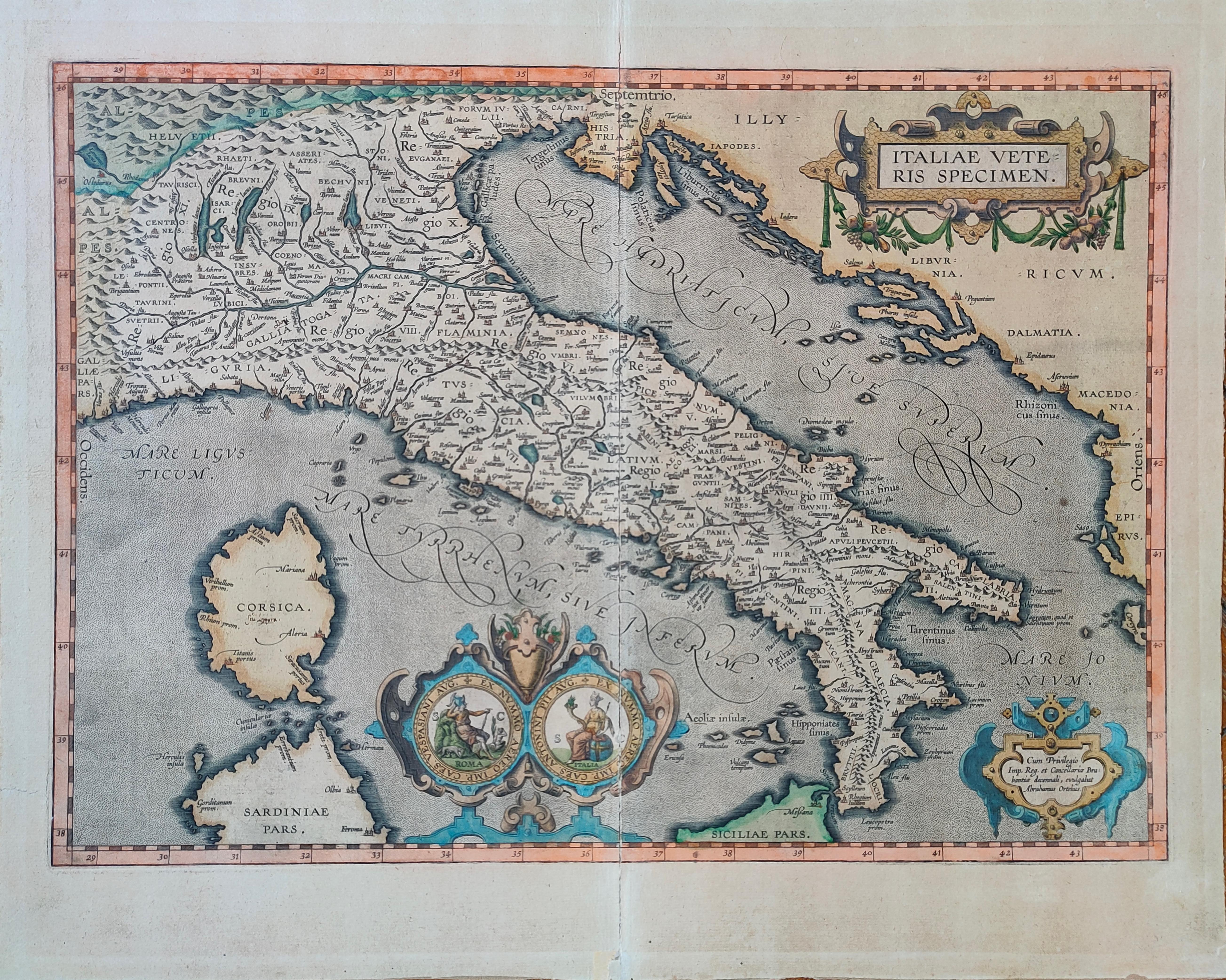
Map title
Italiae Veteris Speciem
Author
Ortelius
Location shown in map
Italy
Edition date
1612
Edition place
Antwerp
Editor
--
Atlas
Epitome theatri Orteliani
Price
900 Euro
State
[mint/EXCELLENT/very good/good/fair/mediocre/poor]
Color
Old colors
Verso
Latin Text pag.xx
Size
Plate: cm (48 x 35) inches (18.9 x 13.78) Paper: cm (55 x 43) inches (21.65 x 16.93)
Technique
Copper engraving
Note
Reference
Van Den Broecke 257
Wiki
Here for more info
In stock
Available
Info
info@thetreasuremaps.com
Code
#1272
×
![Italiae Veteris Speciem by Ortelius, Italy, 1612]()
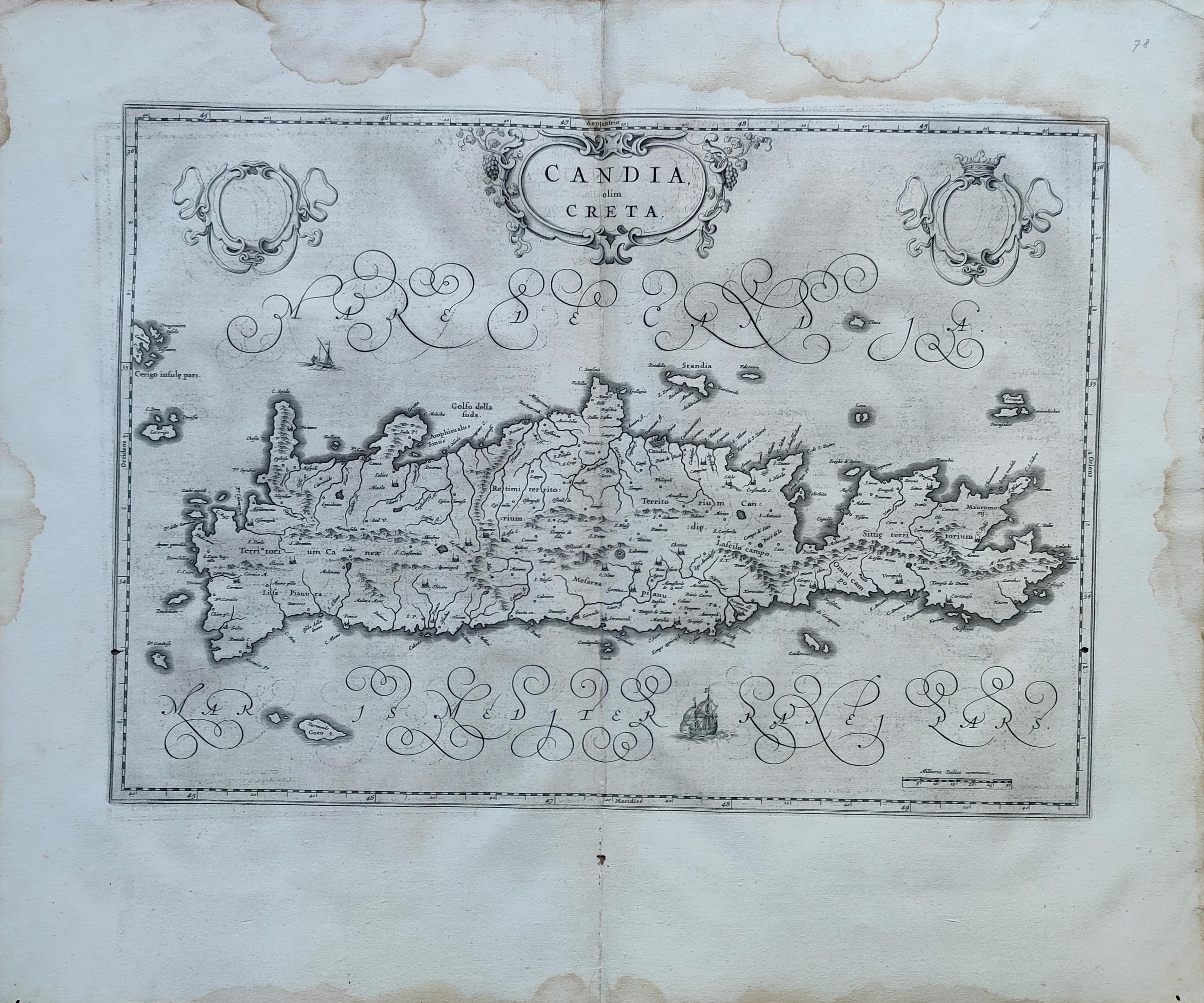
Map title
Candia olim Creta
Author
Blaeu
Location shown in map
Crete
Edition date
Circa 1650
Edition place
Amsterdam
Editor
Blaeu
Atlas
Atlas Maior
Price
300 Euro
State
[mint/EXCELLENT/very good/good/fair/mediocre/poor]
Color
Black/white
Verso
Spanish text
Size
Plate: cm (53 x 39) inches (20.87 x 15.35) Paper: cm (64 x 55) inches (25.2 x 21.65)
Technique
Copper engraving
Note
Reference
Wiki
Here for more info
In stock
Available
Info
info@thetreasuremaps.com
Code
#1271
×
![Candia olim Creta by Blaeu, Crete, Circa 1650]()
Map title
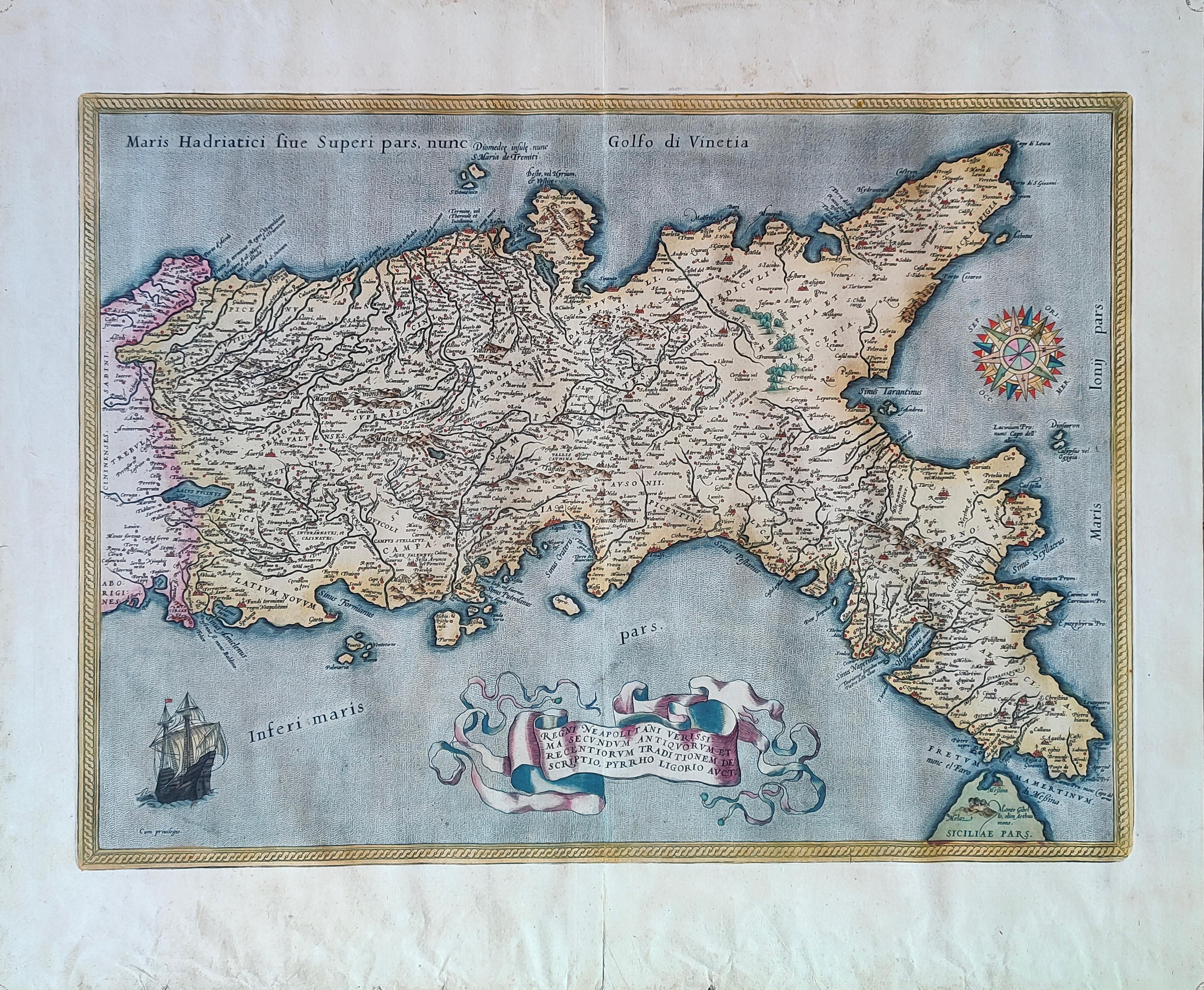
Regni Neapolitani verissima secundum antiquorum et recentiorum traditionem descriptio.
Author
Ortelius
Location shown in map
South Italy
Edition date
1595
Edition place
Antwerp
Editor
--
Atlas
Price
700 Euro
State
[mint/EXCELLENT/very good/good/fair/mediocre/poor]
Color
Old colors
Verso
Latin Text pag.xx
Size
Plate: cm (50 x 37) inches (19.69 x 14.57) Paper: cm (57 x 47) inches (22.44 x 18.5)
Technique
Copper engraving
Note
Reference
Van Den Broecke 187
Wiki
Here for more info
In stock
Available
Info
info@thetreasuremaps.com
Code
#1273
×
![Regni Neapolitani verissima secundum antiquorum et recentiorum traditionem descriptio. by Ortelius, South Italy, 1595]()
Map title
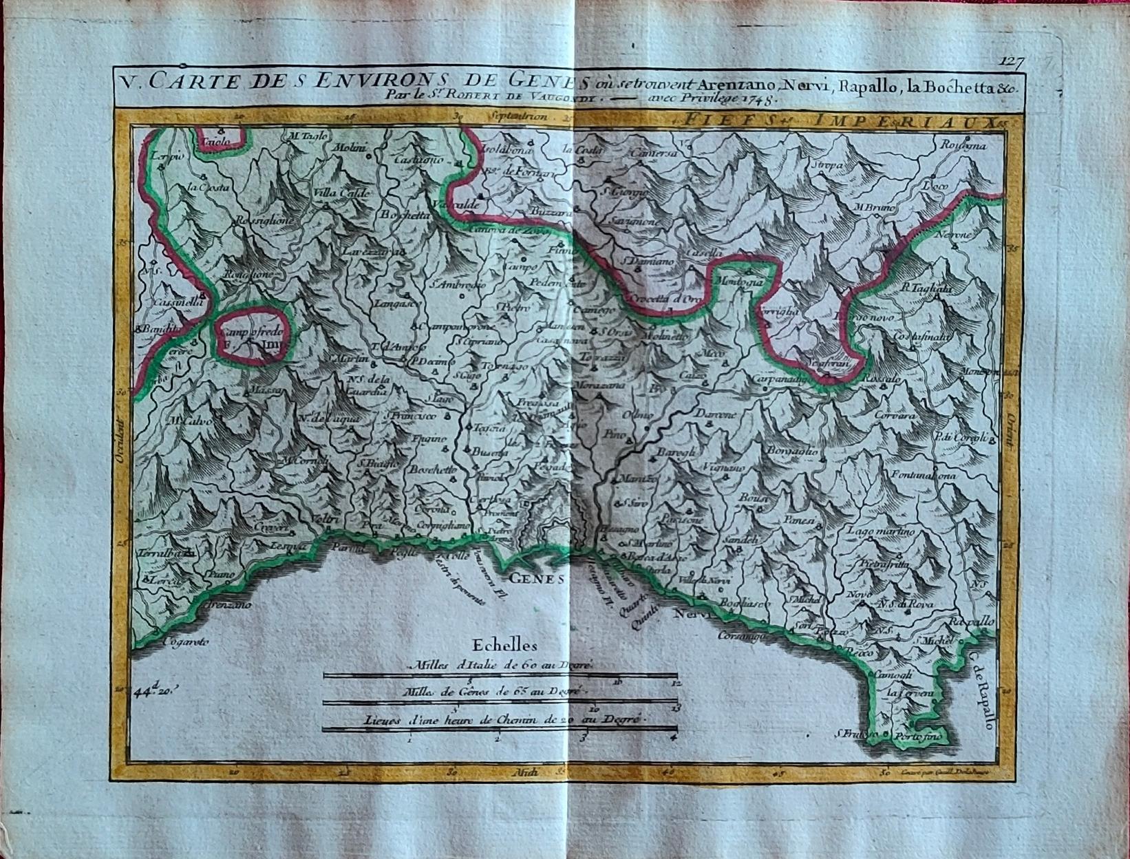
Carte des environs de Genes
Author
Vaugondy
Location shown in map
Liguria
Edition date
1748
Edition place
Paris
Editor
Atlas
Price
175 Euro
State
[mint/EXCELLENT/very good/good/fair/mediocre/poor]
Color
Old colors
Verso
Blank
Size
Plate: cm (20 x 15.5) inches (7.87 x 6.1) Paper: cm (24 x 19) inches (9.45 x 7.48)
Technique
Copper engraving
Note
Reference
Wiki
Here for more info
In stock
Available
Info
info@thetreasuremaps.com
Code
#1264
×
![Carte des environs de Genes by Vaugondy, Liguria, 1748]()
Map title
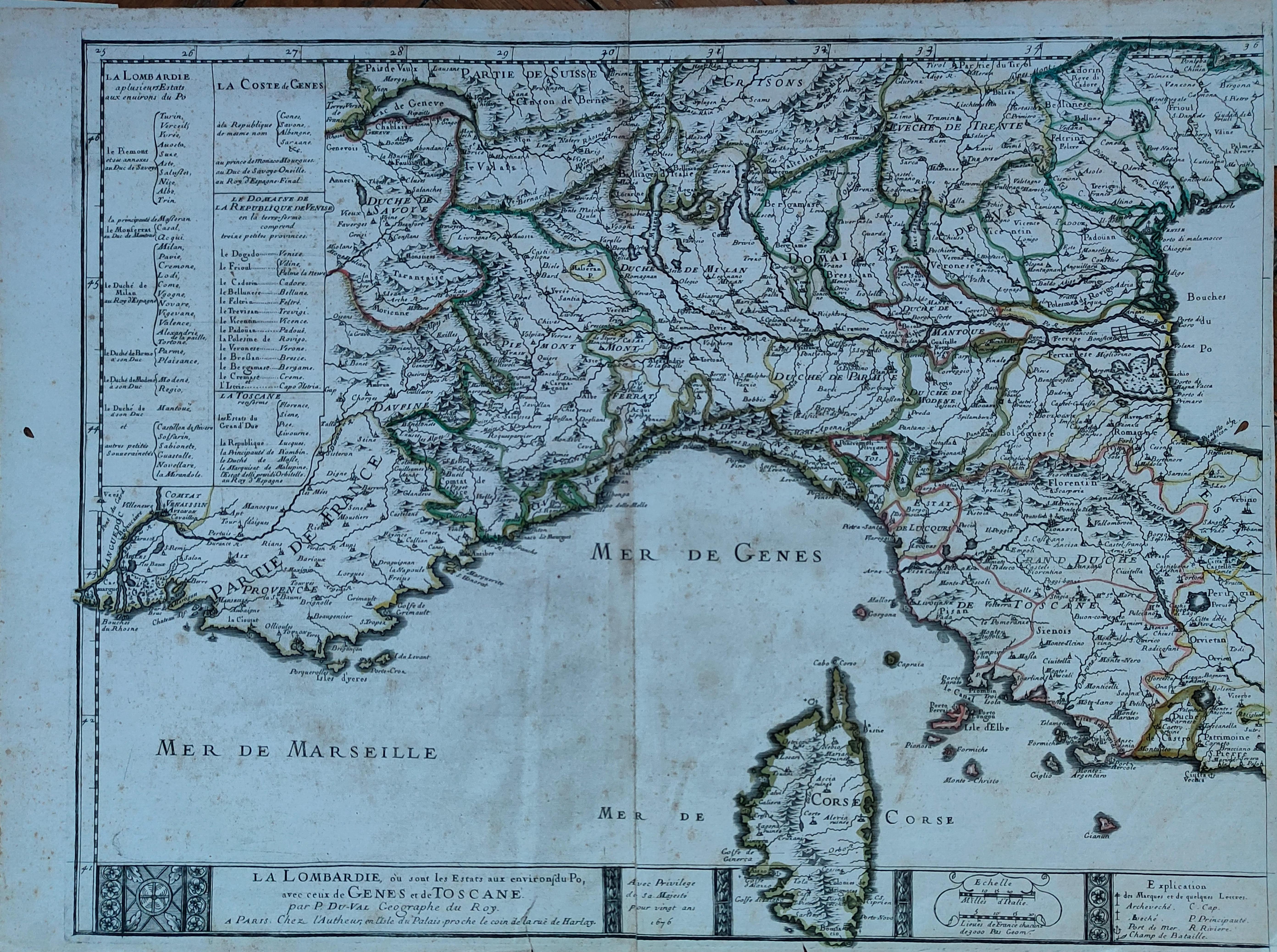
La Lombardie
Author
Du Val
Location shown in map
North Italy
Edition date
1676
Edition place
Paris
Editor
Atlas
Price
300 Euro
State
[mint/EXCELLENT/very good/good/fair/mediocre/poor]
Color
Old colors
Verso
Blank
Size
Plate: cm (54 x 42) inches (21.26 x 16.54) Paper: cm (59 x 43) inches (23.23 x 16.93)
Technique
Copper engraving
Note
Reference
Wiki
Here for more info
In stock
Available
Info
info@thetreasuremaps.com
Code
#1266
×
![La Lombardie by Du Val, North Italy, 1676]()
Map title
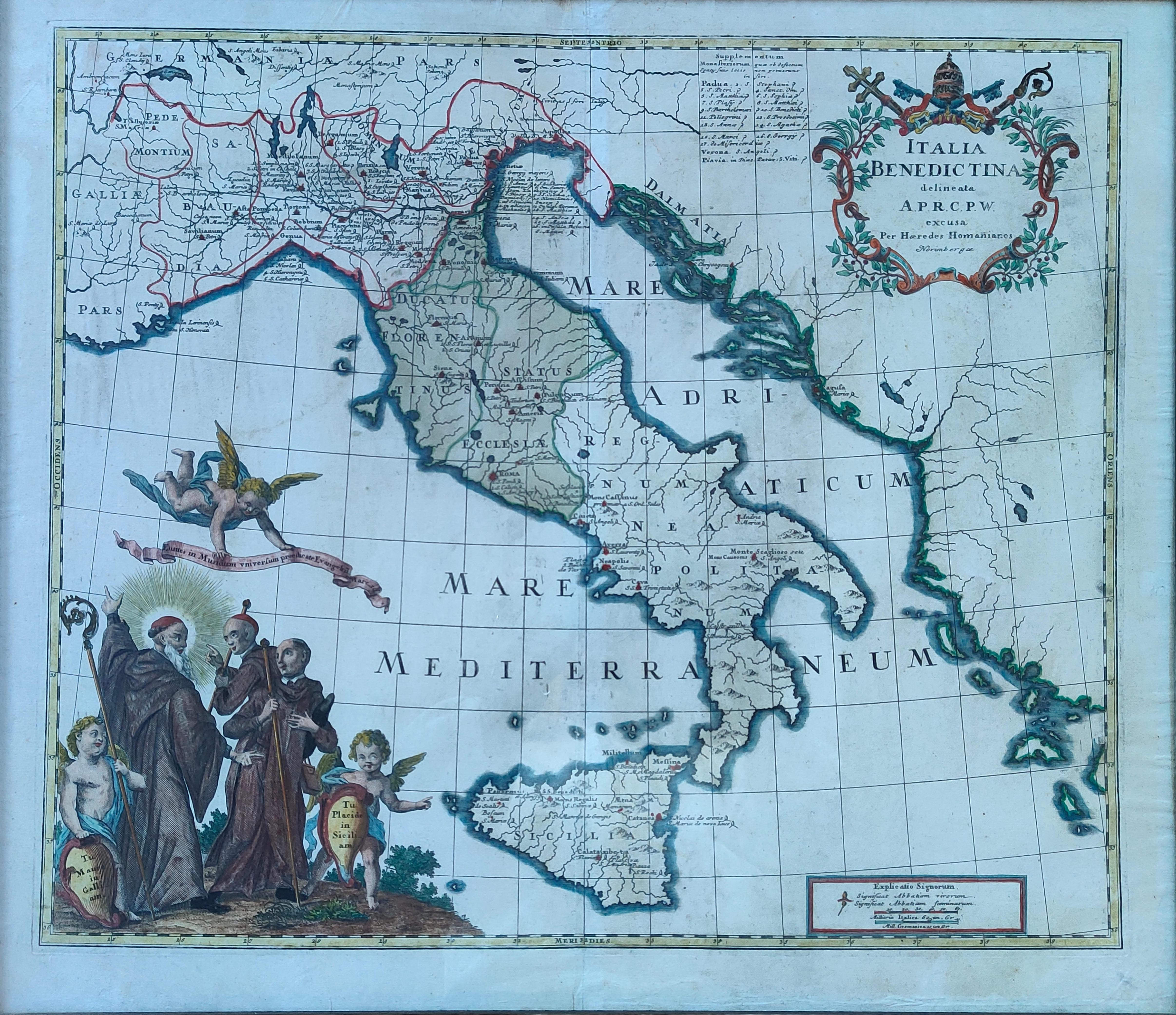
Italia Benedictina
Author
Homann
Location shown in map
Italy
Edition date
Circa 1750
Edition place
Nurimberg
Editor
Atlas
Price
500 Euro
State
[mint/EXCELLENT/very good/good/fair/mediocre/poor]
Color
Old colors
Verso
Blank
Size
Plate: cm (55 x 47) inches (21.65 x 18.5) Paper: cm (60 x 52) inches (23.62 x 20.47)
Technique
Copper engraving
Note
Reference
R.Borri L'Italia nelle antiche carte pag.221
Wiki
Here for more info
In stock
Available
Info
info@thetreasuremaps.com
Code
#1265
×
![Italia Benedictina by Homann, Italy, Circa 1750]()