News
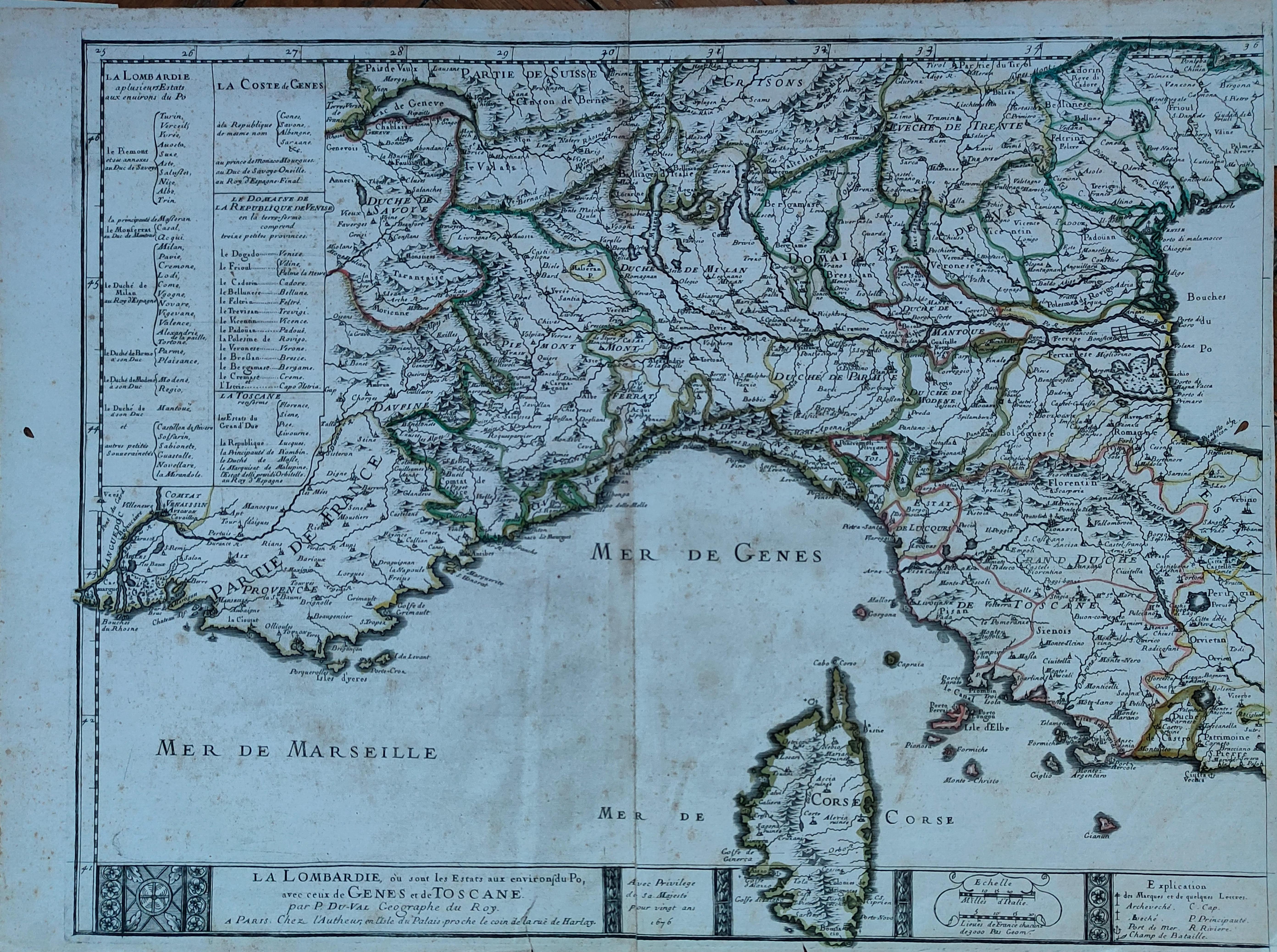
Map title
La Lombardie
Author
Du Val
Location shown in map
North Italy
Edition date
1676
Edition place
Paris
Editor
Atlas
Price
300 Euro
State
[mint/EXCELLENT/very good/good/fair/mediocre/poor]
Color
Old colors
Verso
Blank
Size
Plate: cm (54 x 42) inches (21.26 x 16.54) Paper: cm (59 x 43) inches (23.23 x 16.93)
Technique
Copper engraving
Note
Reference
Wiki
Here for more info
In stock
Available
Info
info@thetreasuremaps.com
Code
#1266
×
![La Lombardie by Du Val, North Italy, 1676]()
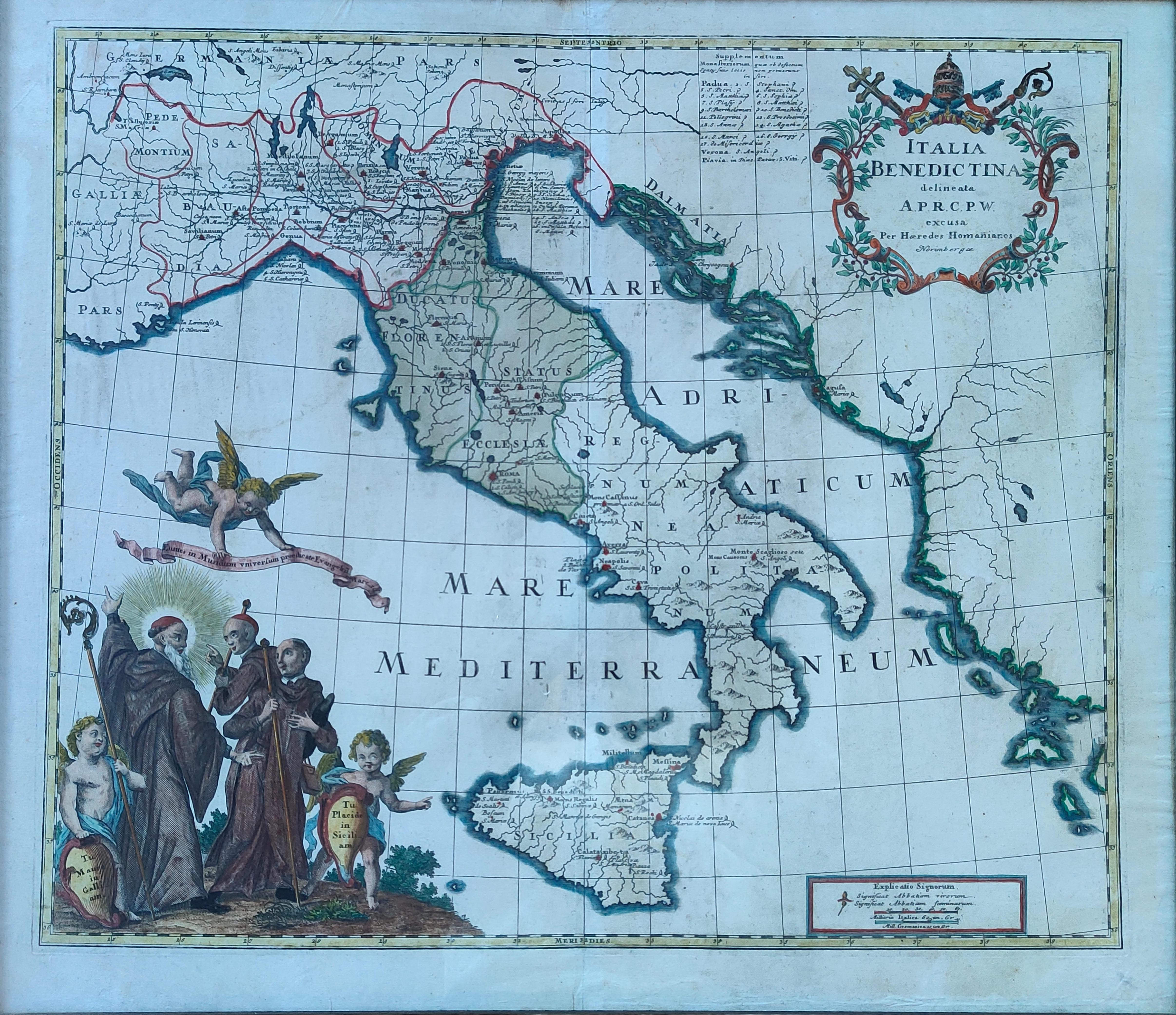
Map title
Italia Benedictina
Author
Homann
Location shown in map
Italy
Edition date
Circa 1750
Edition place
Nurimberg
Editor
Atlas
Price
500 Euro
State
[mint/EXCELLENT/very good/good/fair/mediocre/poor]
Color
Old colors
Verso
Blank
Size
Plate: cm (55 x 47) inches (21.65 x 18.5) Paper: cm (60 x 52) inches (23.62 x 20.47)
Technique
Copper engraving
Note
Reference
R.Borri L'Italia nelle antiche carte pag.221
Wiki
Here for more info
In stock
Available
Info
info@thetreasuremaps.com
Code
#1265
×
![Italia Benedictina by Homann, Italy, Circa 1750]()
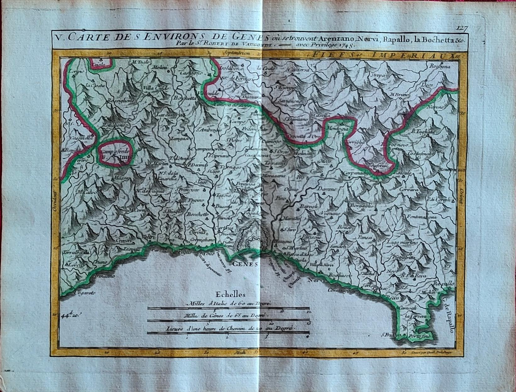
Map title
Carte des environs de Genes
Author
Vaugondy
Location shown in map
Liguria
Edition date
1748
Edition place
Paris
Editor
Atlas
Price
175 Euro
State
[mint/EXCELLENT/very good/good/fair/mediocre/poor]
Color
Old colors
Verso
Blank
Size
Plate: cm (20 x 15.5) inches (7.87 x 6.1) Paper: cm (24 x 19) inches (9.45 x 7.48)
Technique
Copper engraving
Note
Reference
Wiki
Here for more info
In stock
Available
Info
info@thetreasuremaps.com
Code
#1264
×
![Carte des environs de Genes by Vaugondy, Liguria, 1748]()
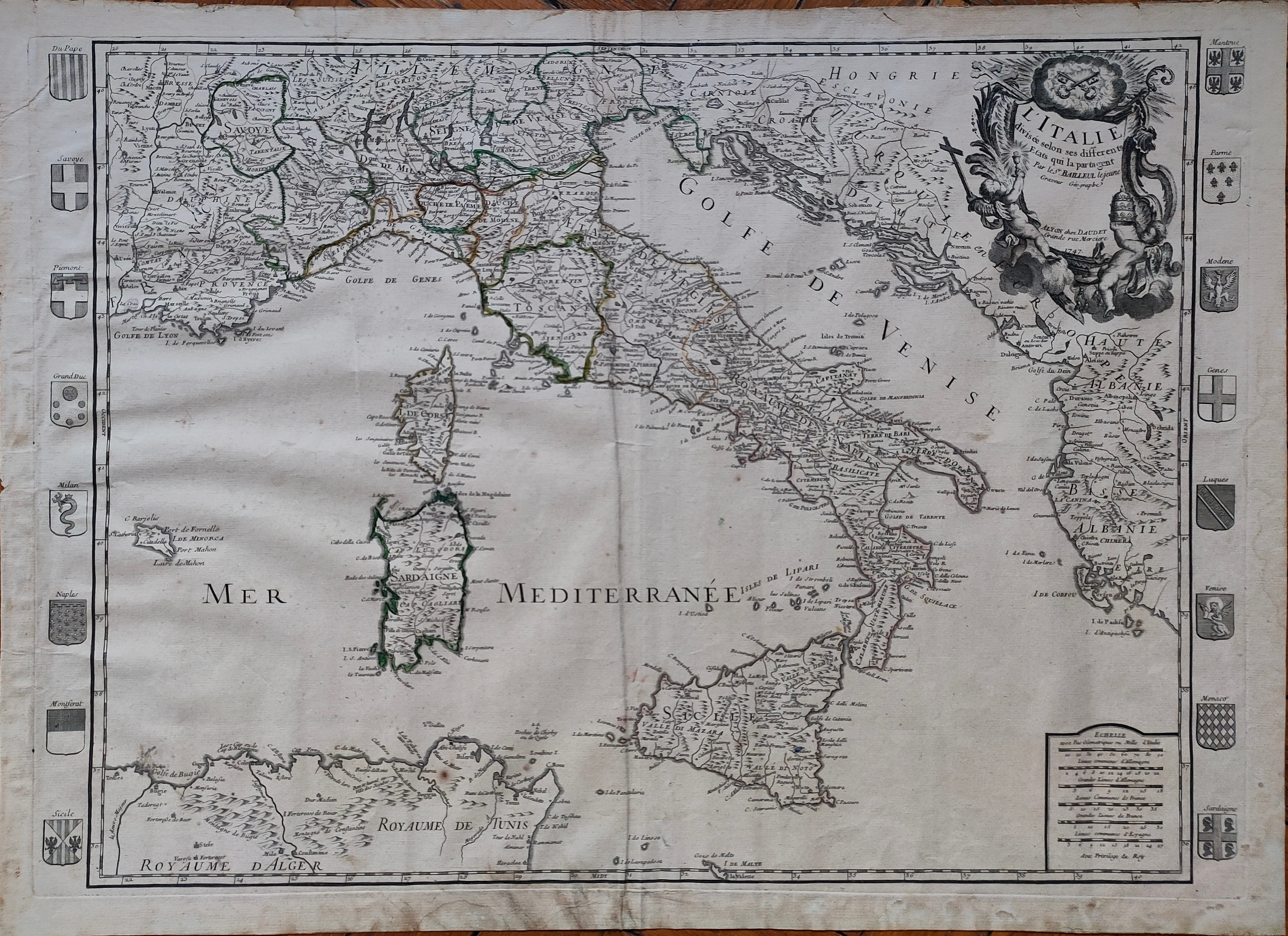
Map title
L'Italie
Author
Bailleul
Location shown in map
Italy
Edition date
1747
Edition place
Paris
Editor
Daudiet
Atlas
Price
600 Euro
State
[mint/EXCELLENT/very good/good/fair/mediocre/poor]
Color
Old colors
Verso
Blank
Size
Plate: cm (71 x 50) inches (27.95 x 19.69) Paper: cm (74 x 54) inches (29.13 x 21.26)
Technique
Copper engraving
Note
Reference
R.Borri L'Italia nelle antiche carte pag.243
Wiki
Here for more info
In stock
Available
Info
info@thetreasuremaps.com
Code
#1260
×
![L'Italie by Bailleul, Italy, 1747]()
Map title
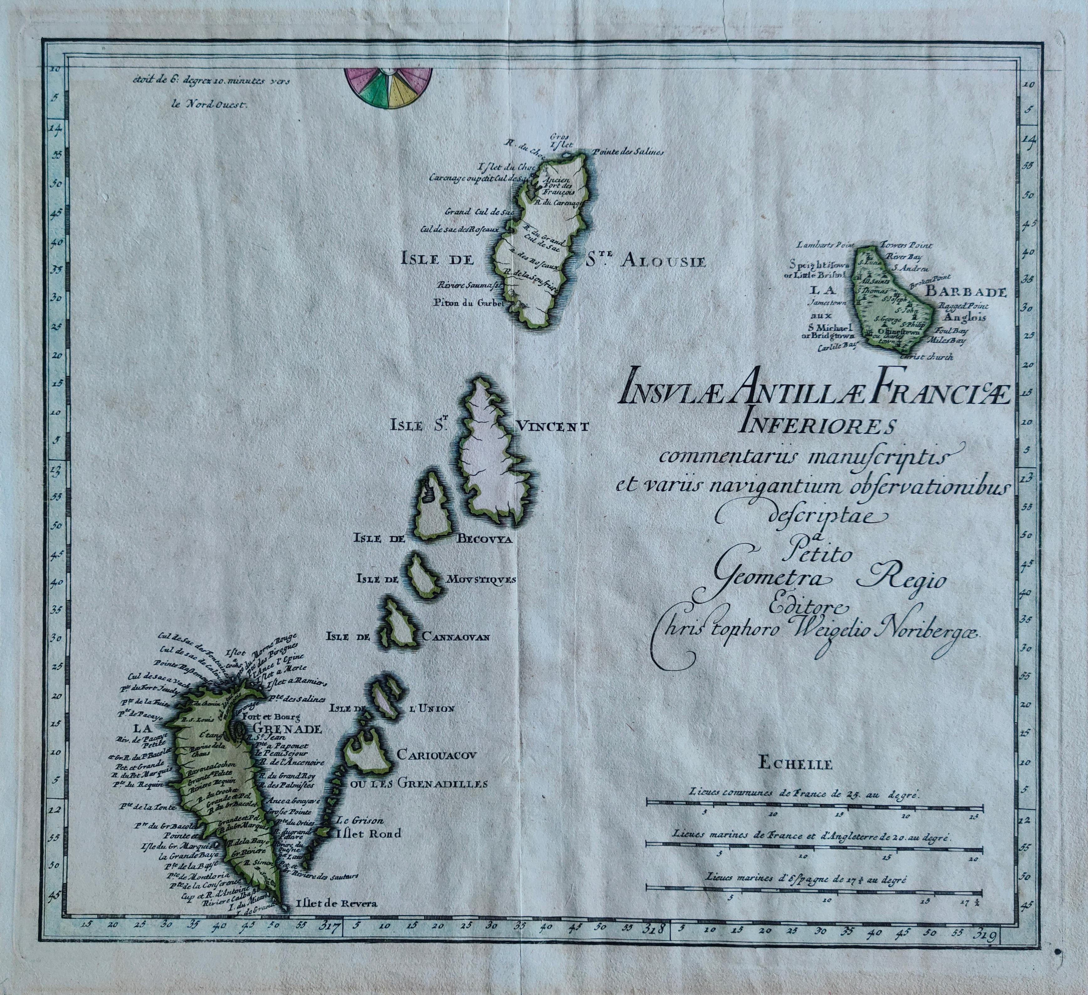
Insulae Antillae Franciae Inferiores
Author
Weigel
Location shown in map
Antille
Edition date
1719
Edition place
Nurimberg
Editor
Atlas
Schul- und Reisen-Atlas Aller Zu Erlernung der Alten
Price
275 Euro
State
[mint/EXCELLENT/very good/good/fair/mediocre/poor]
Color
Old colors
Verso
Blank
Size
Plate: cm (36 x 32) inches (14.17 x 12.6) Paper: cm (40 x 36) inches (15.75 x 14.17)
Technique
Copper engraving
Note
Reference
Wiki
Here for more info
In stock
Available
Info
info@thetreasuremaps.com
Code
#1284
×
![Insulae Antillae Franciae Inferiores by Weigel, Antille, 1719]()
Map title
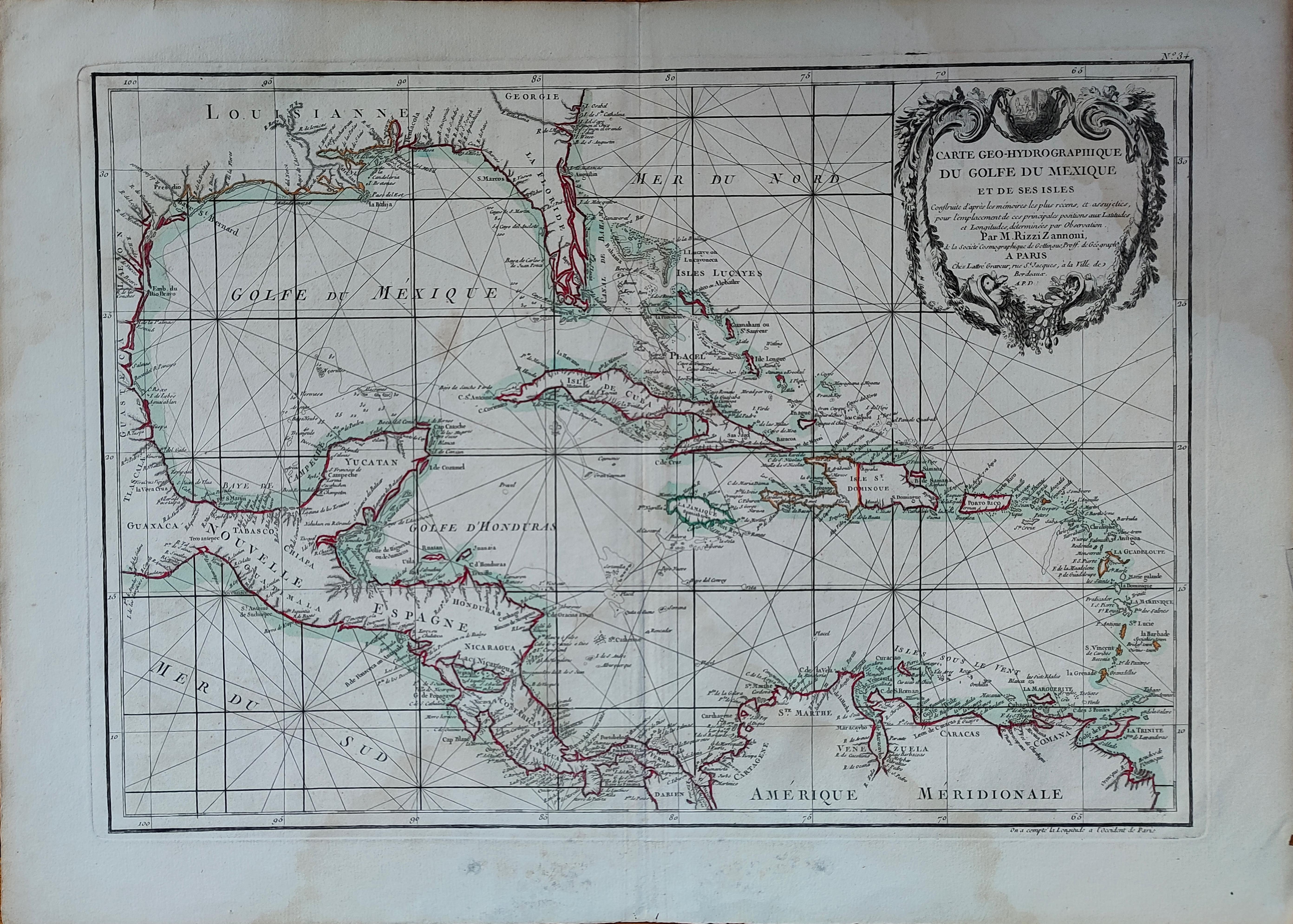
Carte Geo-Hydrographique du golfe du Mexico
Author
Rizzi Zannoni
Location shown in map
West Indies
Edition date
Circa 1780
Edition place
Paris
Editor
Atlas
Price
300 Euro
State
[mint/EXCELLENT/very good/good/fair/mediocre/poor]
Color
Old colors
Verso
Blank
Size
Plate: cm (45 x 31) inches (17.72 x 12.2) Paper: cm (54 x 39) inches (21.26 x 15.35)
Technique
Copper engraving
Note
Reference
Wiki
Here for more info
In stock
Available
Info
info@thetreasuremaps.com
Code
#1263
×
![Carte Geo-Hydrographique du golfe du Mexico by Rizzi Zannoni, West Indies, Circa 1780]()
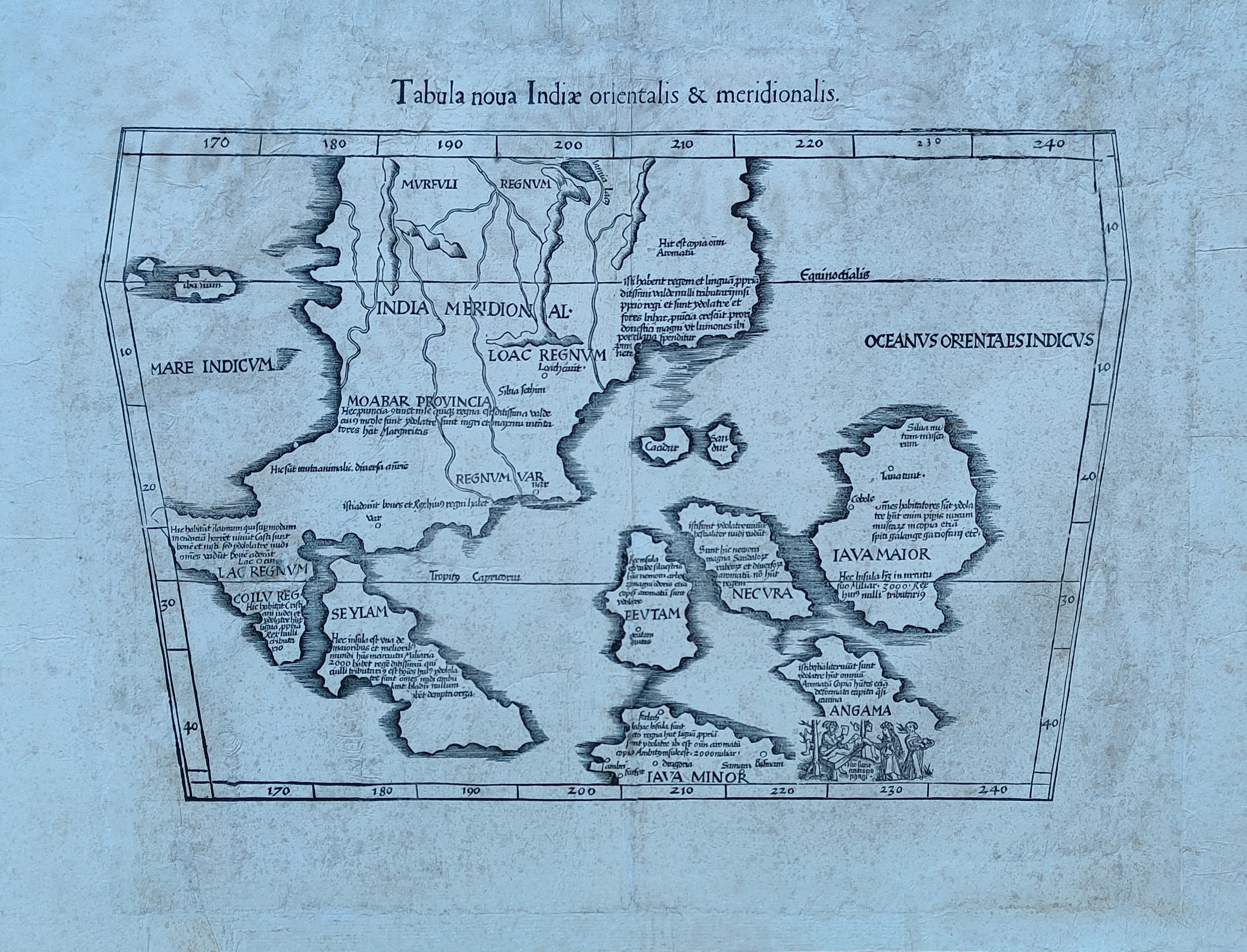
Map title
India orientalis
Author
Fries
Location shown in map
Southeast Asia
Edition date
1541
Edition place
Vienne
Editor
Trechsel, Gaspar
Atlas
Claudii Ptolemaei Alexandrini Geographicae Enarrationis
Price
1200 Euro
State
[mint/excellent/VERY GOOD/good/fair/mediocre/poor]
Color
Black/white
Verso
Blank
Size
Plate: cm (53 x 40) inches (20.87 x 15.75) Paper: cm (53 x 40) inches (20.87 x 15.75)
Technique
Woodcut
Note
Professionaly restored
Reference
--
Wiki
Here for more info
In stock
Available
Info
info@thetreasuremaps.com
Code
#1259
×
![India orientalis by Fries, Southeast Asia, 1541]()
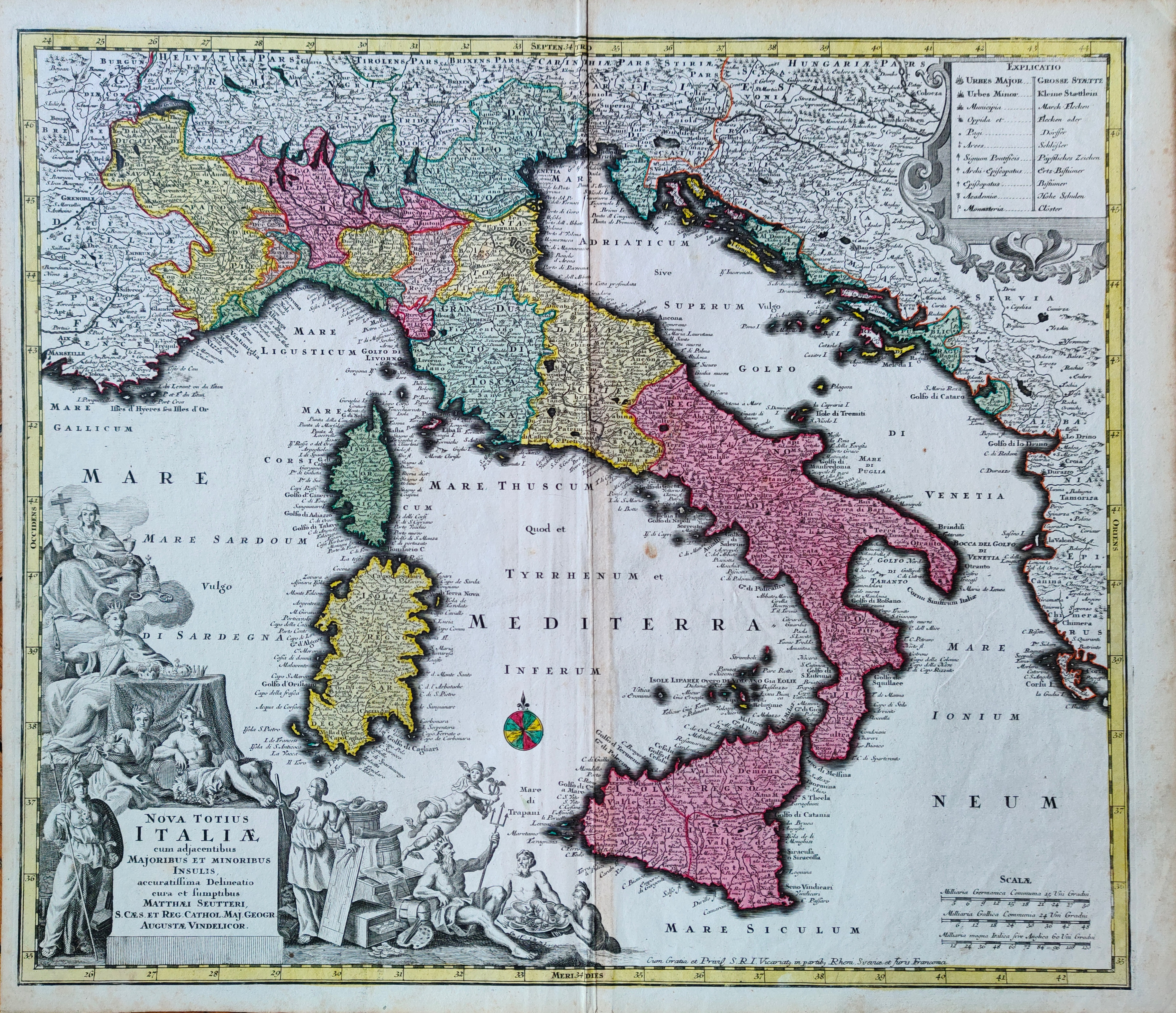
Map title
Nova totius Italiae
Author
Seutter, Matthaus
Location shown in map
Italy
Edition date
Circa 1735
Edition place
Augsburg
Editor
Atlas
Atlas Novus sive Tabulae Geographicae totius orbis faciem, partes, imperia, regna et provincias exhibentes exactissima cura iuxta recontissimas observation
Price
500 Euro
State
[mint/EXCELLENT/very good/good/fair/mediocre/poor]
Color
Old colors
Verso
Blank
Size
Plate: cm (57 x 49) inches (22.44 x 19.29) Paper: cm (60 x 53) inches (23.62 x 20.87)
Technique
Copper engraving
Note
Reference
R.Borri L'Italia nelle antiche carte pag.195
Wiki
Here for more info
In stock
Available
Info
info@thetreasuremaps.com
Code
#1258
×
![Nova totius Italiae by Seutter, Matthaus, Italy, Circa 1735]()
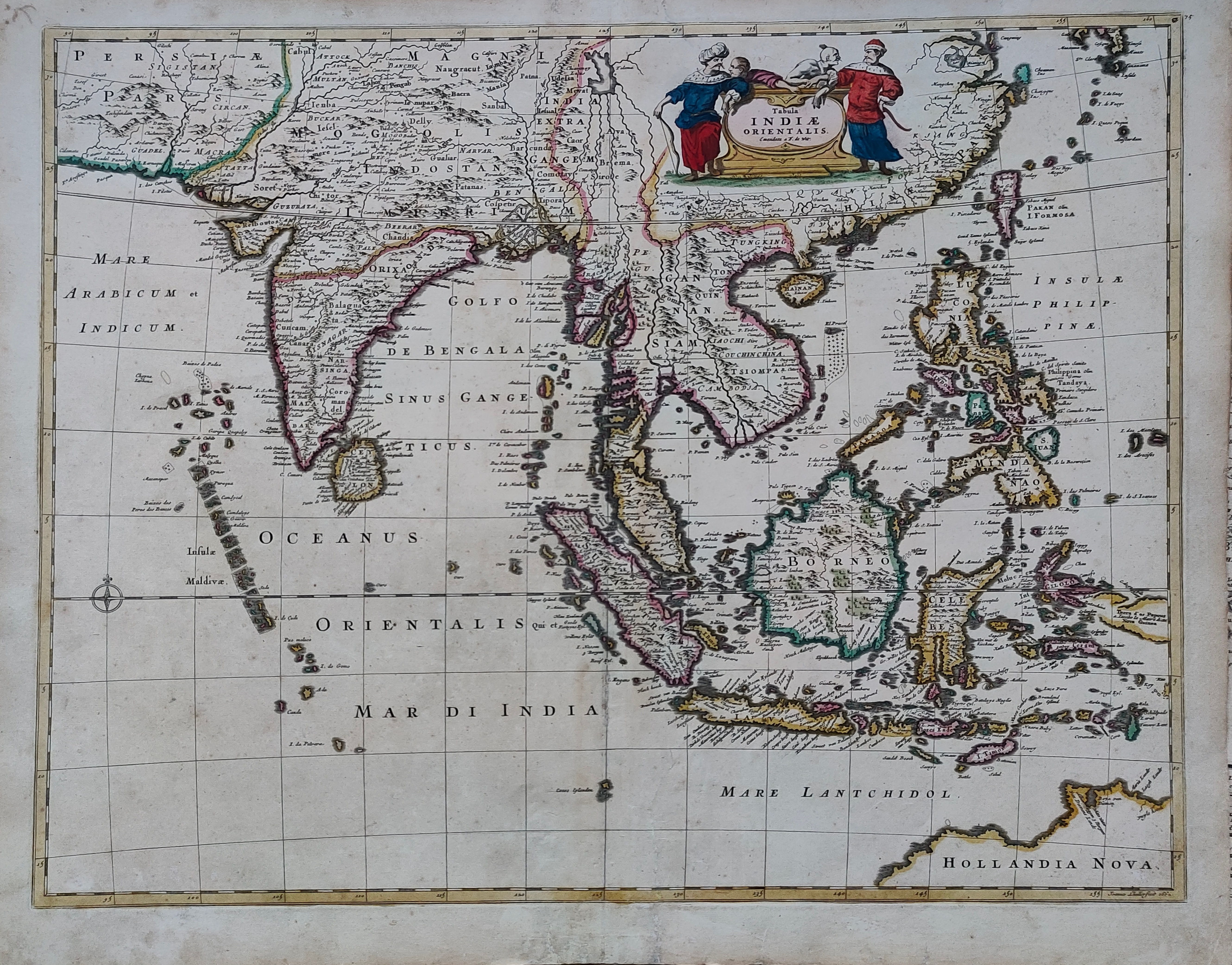
Map title
Tabula Indiae Orientalis
Author
De Witt
Location shown in map
South East
Edition date
Circa 1662
Edition place
Amsterdam
Editor
Atlas
Price
1200 Euro
State
[mint/EXCELLENT/very good/good/fair/mediocre/poor]
Color
Old colors
Verso
Blank
Size
Plate: cm (58 x 46) inches (22.83 x 18.11) Paper: cm (62 x 53) inches (24.41 x 20.87)
Technique
Copper engraving
Note
Reference
Wiki
Here for more info
In stock
Available
Info
info@thetreasuremaps.com
Code
#1261
×
![Tabula Indiae Orientalis by De Witt, South East, Circa 1662]()
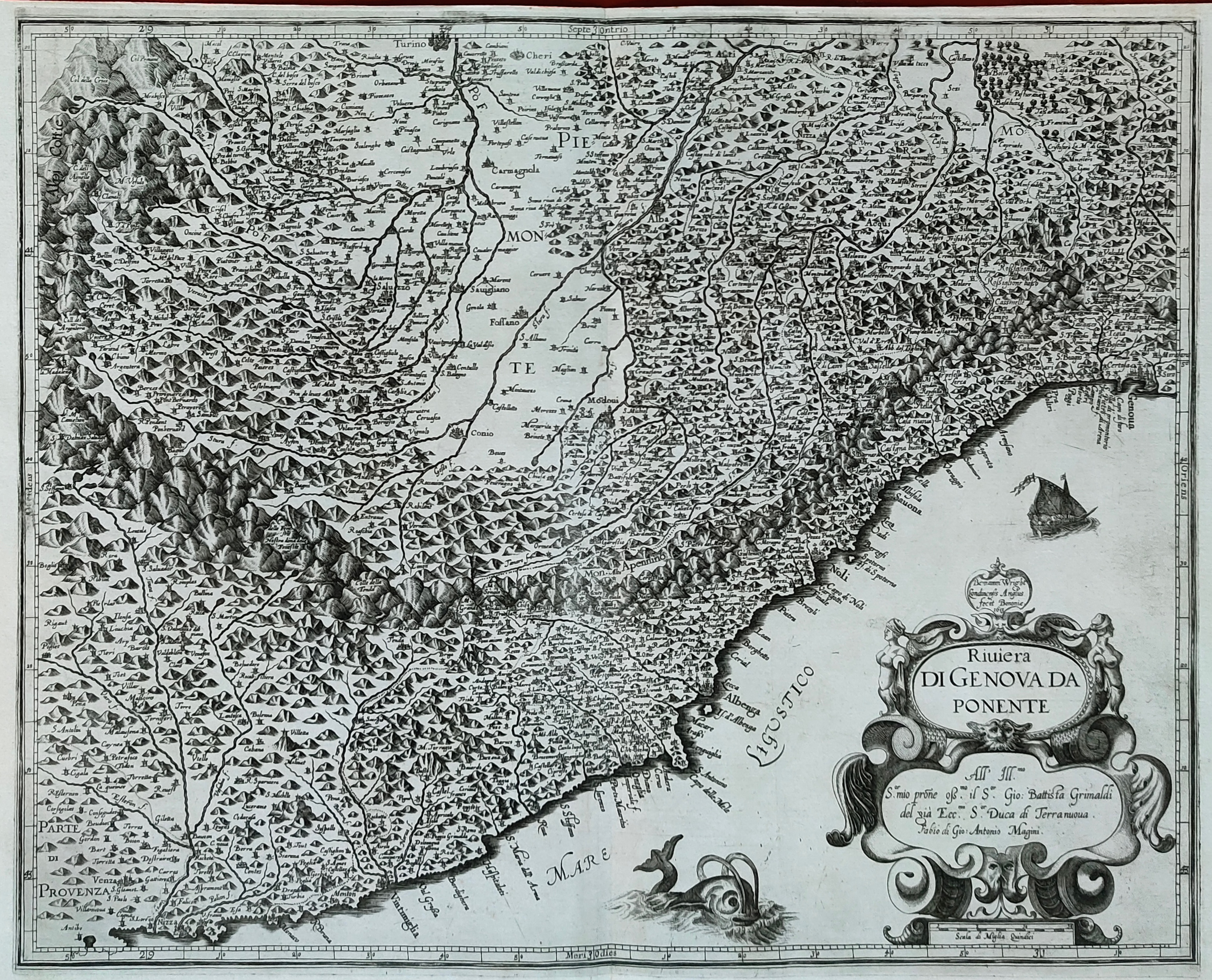
Map title
Riviera di Genova da Ponente
Author
Magini
Location shown in map
Liguria
Edition date
1620
Edition place
Bolonia
Editor
Magini
Atlas
Italia
Price
500 Euro
State
[mint/EXCELLENT/very good/good/fair/mediocre/poor]
Color
Black/white
Verso
Blank
Size
Plate: cm (48 x 38) inches (18.9 x 14.96) Paper: cm (53 x 39) inches (20.87 x 15.35)
Technique
Copper engraving
Note
Reference
--
Wiki
Here for more info
In stock
Available
Info
info@thetreasuremaps.com
Code
#1244
×
![Riviera di Genova da Ponente by Magini, Liguria, 1620]()
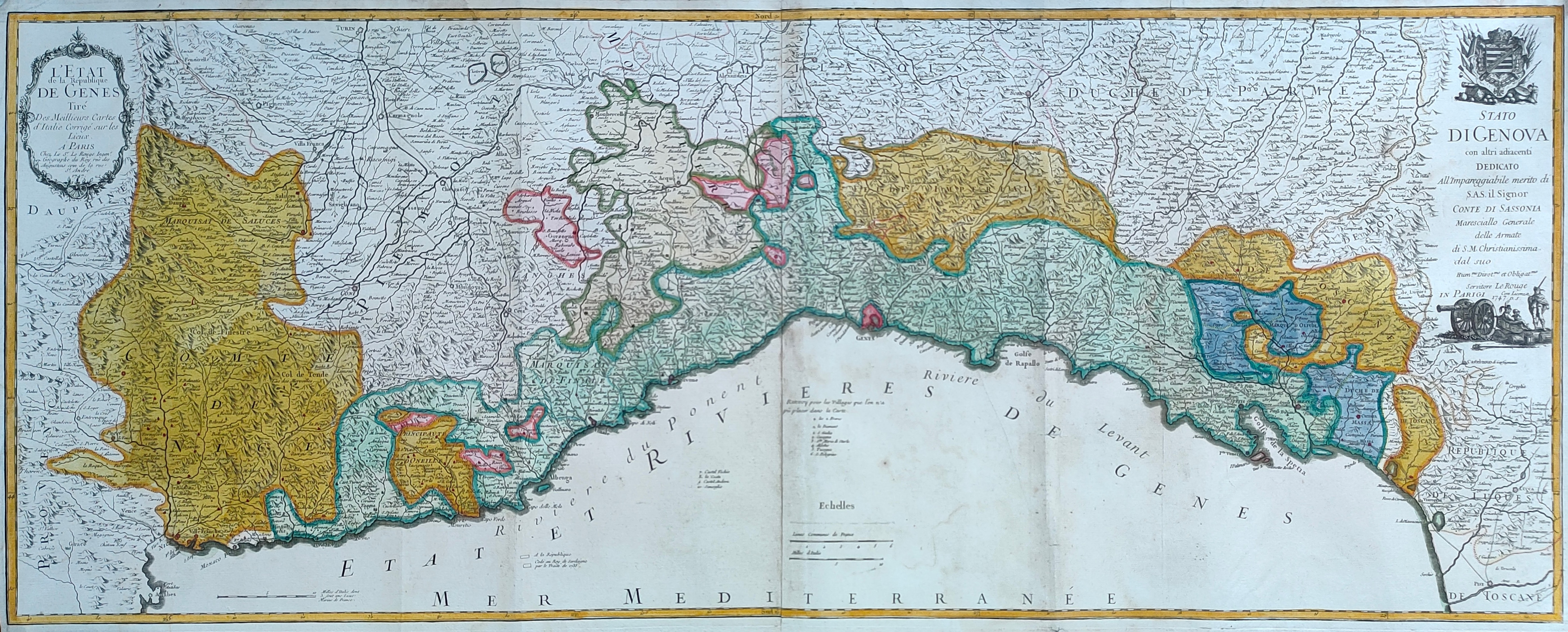
Map title
L'Etat de la republique de Genes
Author
Le Rouge
Location shown in map
Liguria
Edition date
1747
Edition place
Paris
Editor
Atlas
Price
600 Euro
State
[mint/EXCELLENT/very good/good/fair/mediocre/poor]
Color
Old colors
Verso
Blank
Size
Plate: cm (110 x 44) inches (43.31 x 17.32) Paper: cm (114 x 48) inches (44.88 x 18.9)
Technique
Copper engraving
Note
Reference
Wiki
Here for more info
In stock
Available
Info
info@thetreasuremaps.com
Code
#1245
×
![L'Etat de la republique de Genes by Le Rouge, Liguria, 1747]()
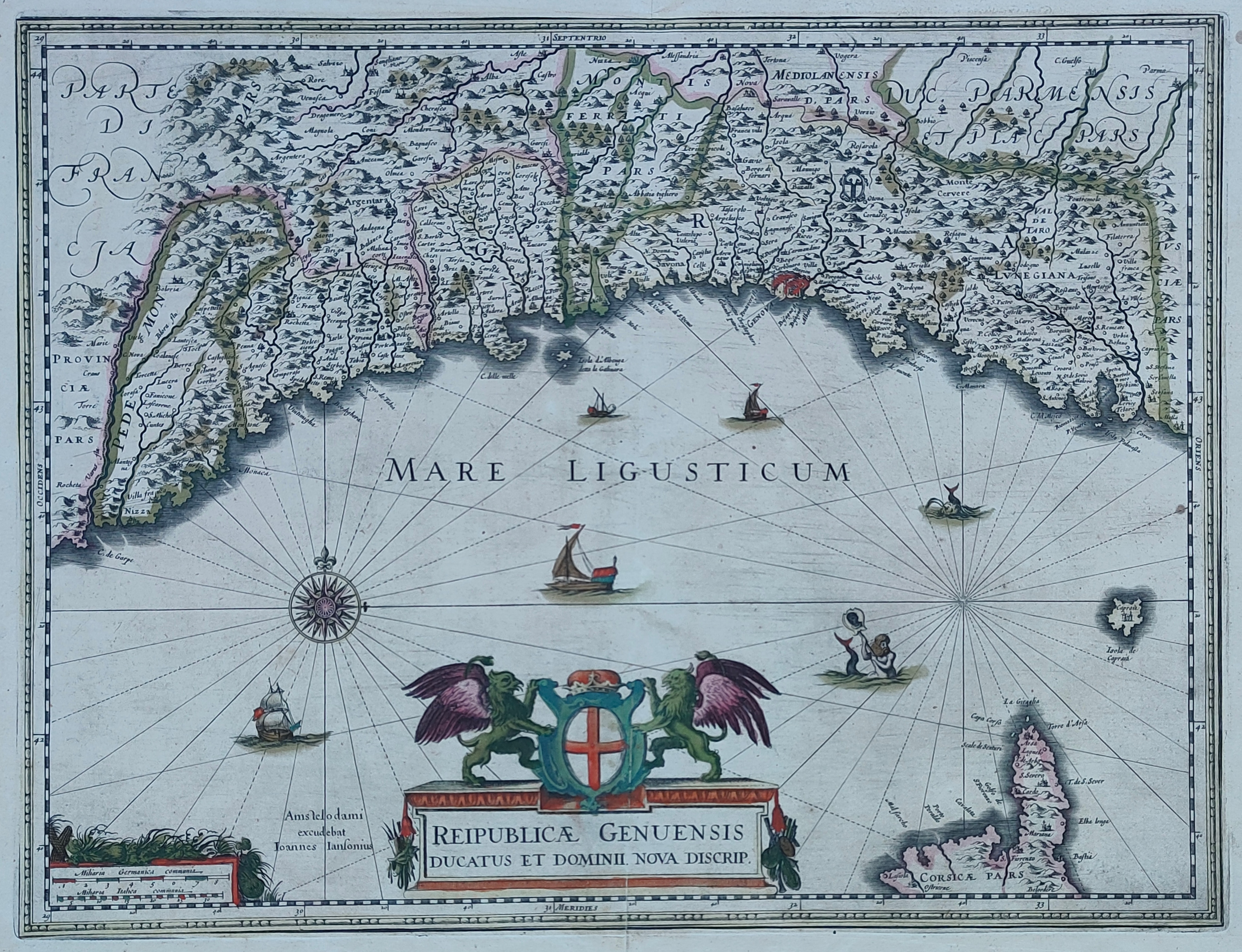
Map title
Reipublicae Genuensis Ducatus Et Dominii.
Author
Jansson
Location shown in map
Liguria
Edition date
Circa 1638
Edition place
Amsterdam
Editor
Hondius
Atlas
Atlas sive Cosmographicae meditationes de fabrica mvndi et fabricati figvra
Price
600 Euro
State
[mint/EXCELLENT/very good/good/fair/mediocre/poor]
Color
Old colors
Verso
German text
Size
Plate: cm (49 x 38) inches (19.29 x 14.96) Paper: cm (58 x 51) inches (22.83 x 20.08)
Technique
Copper engraving
Note
Reference
Wiki
Here for more info
In stock
Available
Info
info@thetreasuremaps.com
Code
#1257
×
![Reipublicae Genuensis Ducatus Et Dominii. by Jansson, Liguria, Circa 1638]()
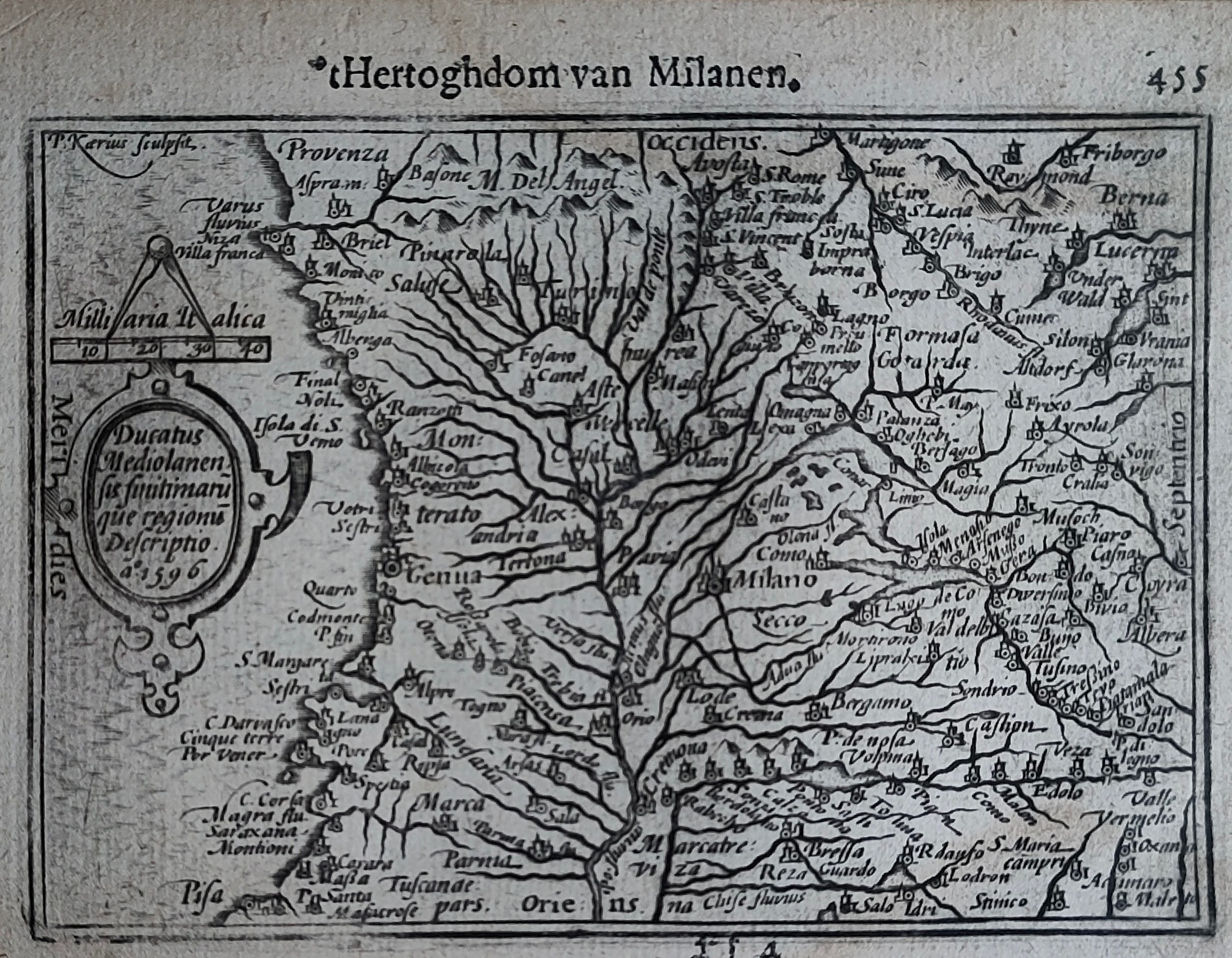
Map title
Hertoghdom van Milanen
Author
Bertius
Location shown in map
Liguria
Edition date
Circa 1606
Edition place
Amsterdam
Editor
Atlas
Price
200 Euro
State
[mint/EXCELLENT/very good/good/fair/mediocre/poor]
Color
Black/white
Verso
Duch text pag.456
Size
Plate: cm (12 x 9) inches (4.72 x 3.54) Paper: cm (18 x 11) inches (7.09 x 4.33)
Technique
Copper engraving
Note
Reference
Wiki
Here for more info
In stock
Available
Info
info@thetreasuremaps.com
Code
#1246
×
![Hertoghdom van Milanen by Bertius, Liguria, Circa 1606]()
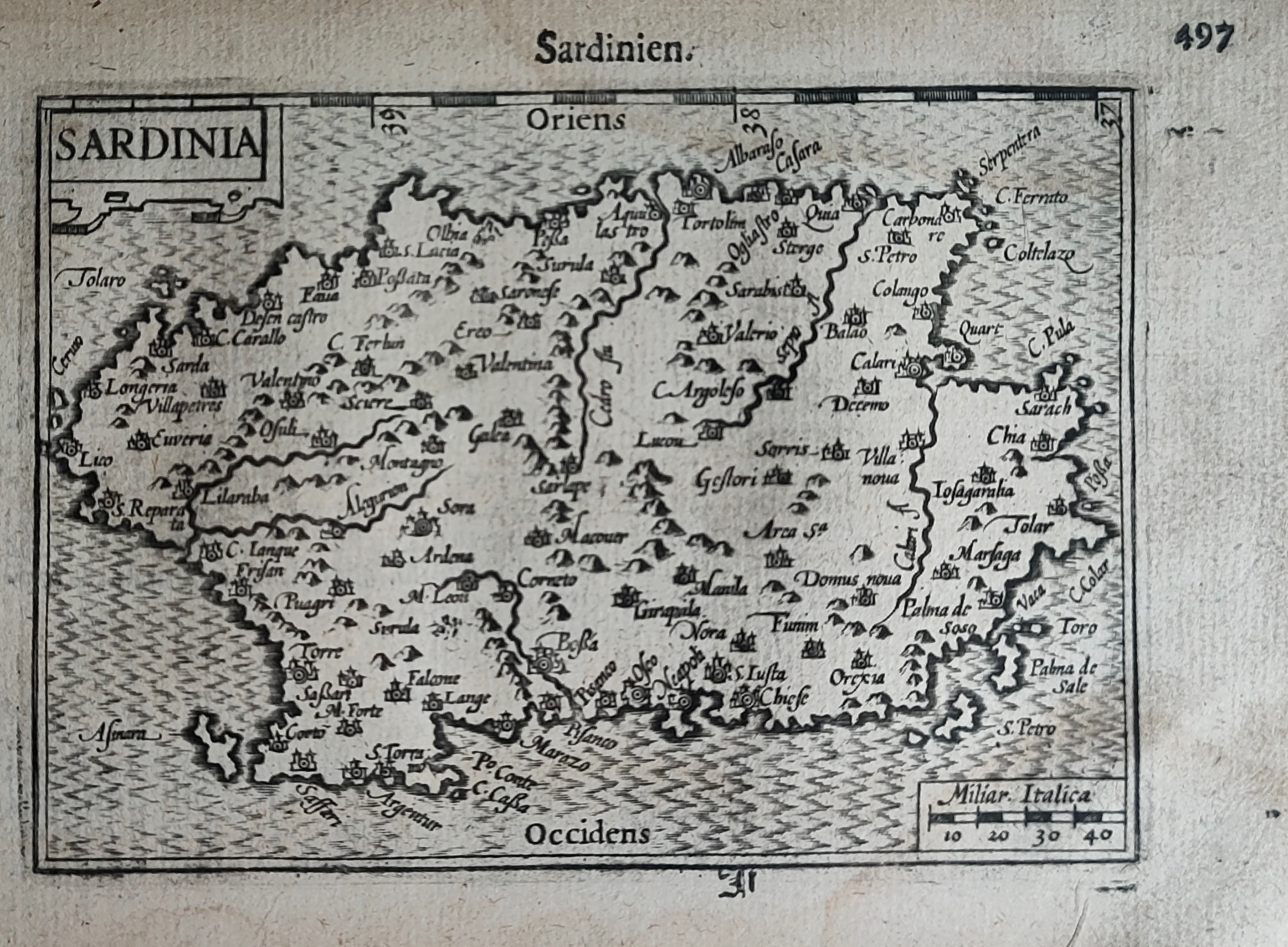
Map title
Sardinien
Author
Bertius
Location shown in map
Sardinia
Edition date
Circa 1606
Edition place
Amsterdam
Editor
Atlas
Price
250 Euro
State
[mint/EXCELLENT/very good/good/fair/mediocre/poor]
Color
Black/white
Verso
Duch text pag.498
Size
Plate: cm (12 x 9) inches (4.72 x 3.54) Paper: cm (18 x 11) inches (7.09 x 4.33)
Technique
Copper engraving
Note
Reference
Wiki
Here for more info
In stock
Available
Info
info@thetreasuremaps.com
Code
#1247
×
![Sardinien by Bertius, Sardinia, Circa 1606]()
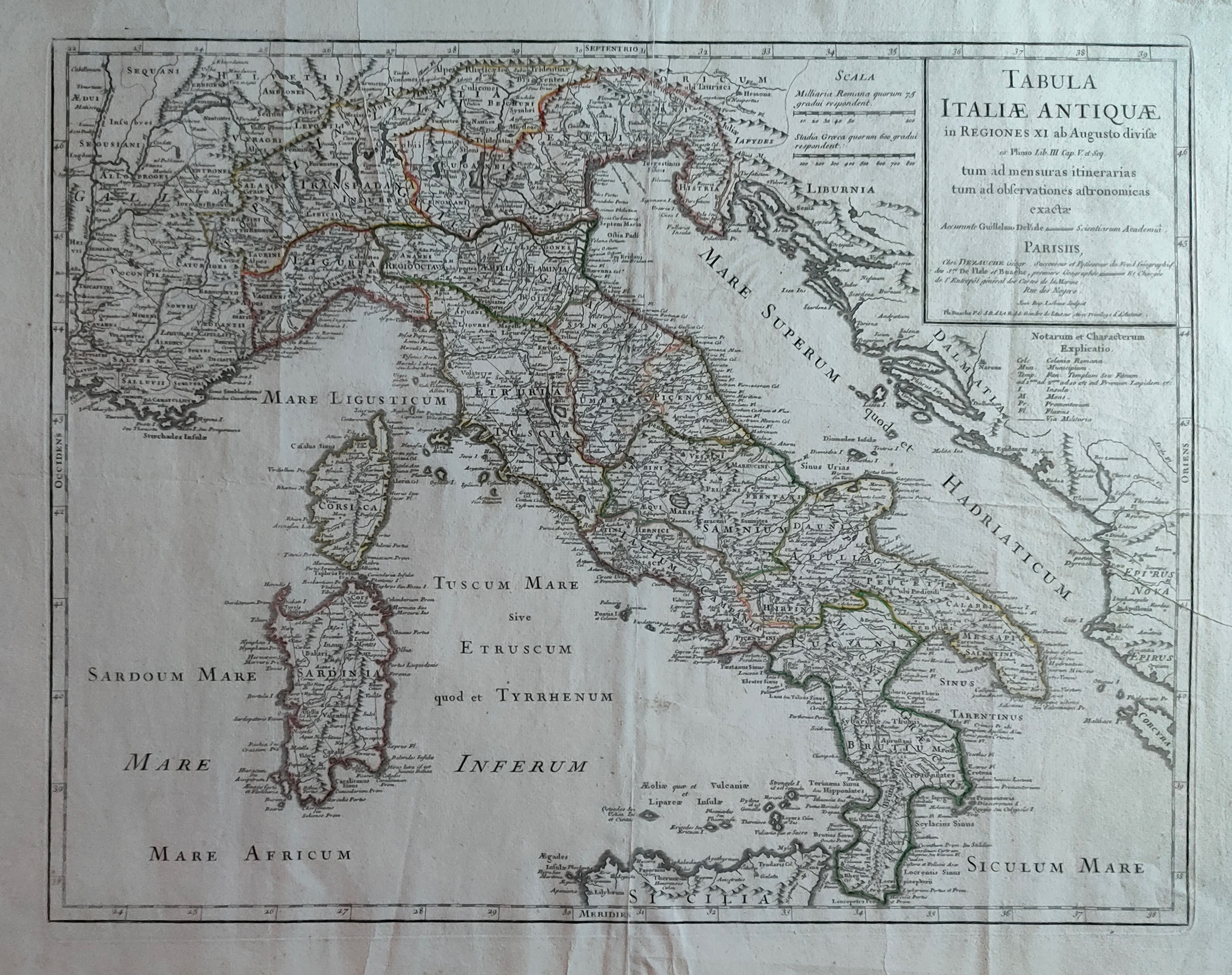
Map title
Tabula Italiae antiquae
Author
De L'Isle
Location shown in map
Italy
Edition date
Circa 1780
Edition place
Paris
Editor
Dezauche
Atlas
Price
300 Euro
State
[mint/EXCELLENT/very good/good/fair/mediocre/poor]
Color
Old colors
Verso
Blank
Size
Plate: cm (64 x 50) inches (25.2 x 19.69) Paper: cm (81 x 57) inches (31.89 x 22.44)
Technique
Copper engraving
Note
Reference
Wiki
Here for more info
In stock
Available
Info
info@thetreasuremaps.com
Code
#1248
×
![Tabula Italiae antiquae by De L'Isle, Italy, Circa 1780]()
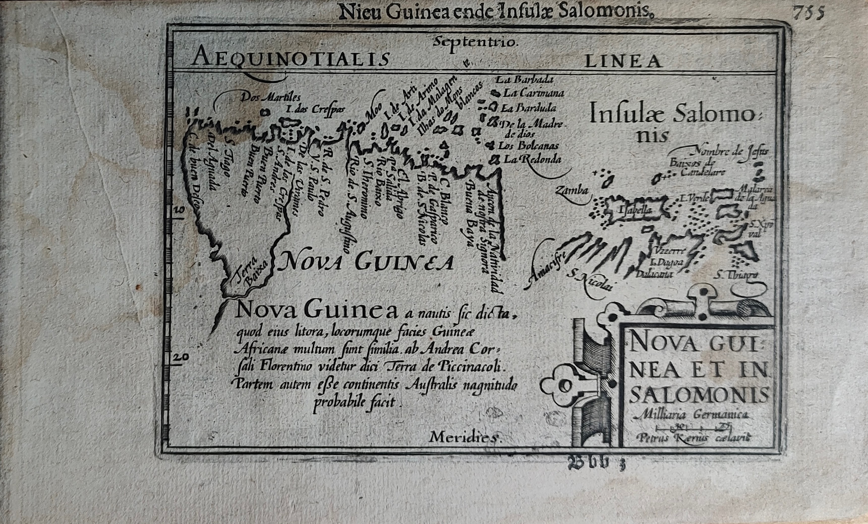
Map title
Nieu Guinea ende Insulae Salomonis
Author
Bertius
Location shown in map
New Guinea
Edition date
Circa 1606
Edition place
Amsterdam
Editor
Atlas
Price
300 Euro
State
[mint/EXCELLENT/very good/good/fair/mediocre/poor]
Color
Black/white
Verso
Duch text pag.756
Size
Plate: cm (12 x 9) inches (4.72 x 3.54) Paper: cm (18 x 11) inches (7.09 x 4.33)
Technique
Copper engraving
Note
Reference
Wiki
Here for more info
In stock
Available
Info
info@thetreasuremaps.com
Code
#1249
×
![Nieu Guinea ende Insulae Salomonis by Bertius, New Guinea, Circa 1606]()
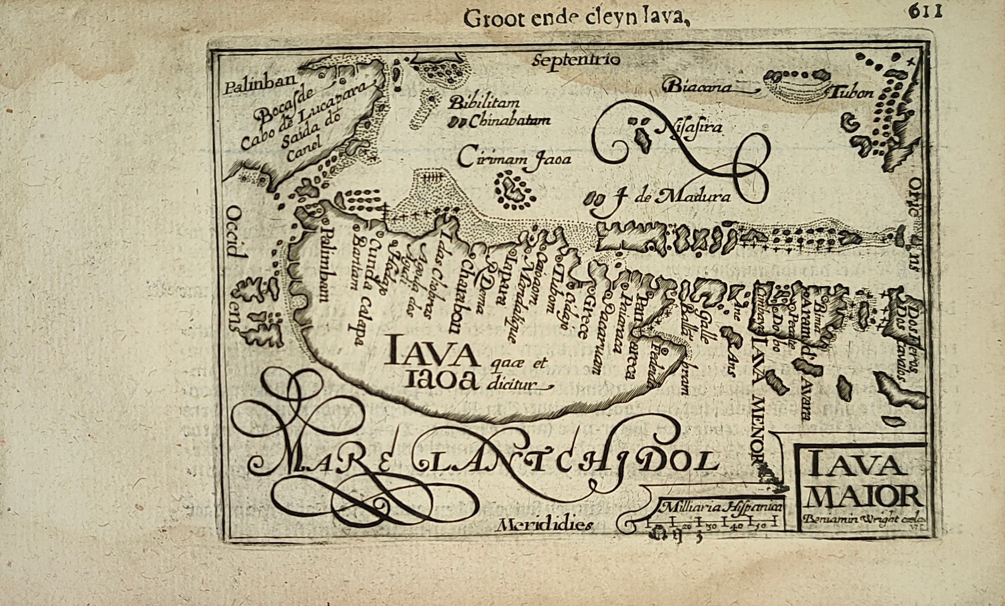
Map title
Groot ende cleyn Iava
Author
Bertius
Location shown in map
Java
Edition date
Circa 1606
Edition place
Amsterdam
Editor
Atlas
Price
300 Euro
State
[mint/EXCELLENT/very good/good/fair/mediocre/poor]
Color
Black/white
Verso
Duch text pag.612
Size
Plate: cm (12 x 9) inches (4.72 x 3.54) Paper: cm (18 x 11) inches (7.09 x 4.33)
Technique
Copper engraving
Note
Reference
Wiki
Here for more info
In stock
Available
Info
info@thetreasuremaps.com
Code
#1251
×
![Groot ende cleyn Iava by Bertius, Java, Circa 1606]()
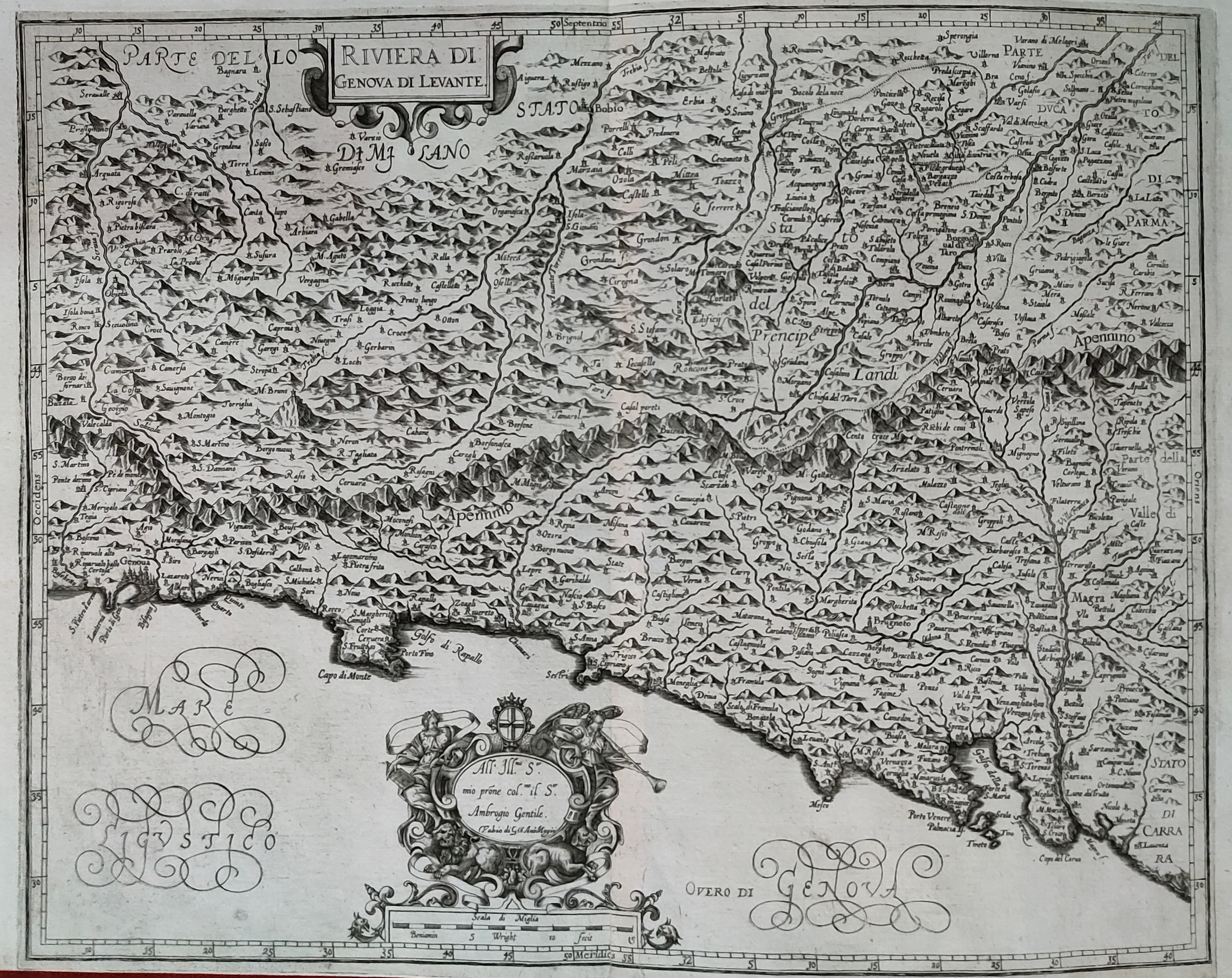
Map title
Riviera di Genova di Levante
Author
Magini
Location shown in map
Liguria
Edition date
1620
Edition place
Bolonia
Editor
Magini
Atlas
Italia
Price
500 Euro
State
[mint/EXCELLENT/very good/good/fair/mediocre/poor]
Color
Black/white
Verso
Blank
Size
Plate: cm (48 x 38) inches (18.9 x 14.96) Paper: cm (53 x 39) inches (20.87 x 15.35)
Technique
Copper engraving
Note
Reference
--
Wiki
Here for more info
In stock
Available
Info
info@thetreasuremaps.com
Code
#1243
×
![Riviera di Genova di Levante by Magini, Liguria, 1620]()
Map title
Mappe-monde
Author
Janvier
Location shown in map
World
Edition date
1782
Edition place
Paris
Editor
Lattre
Atlas
Price
400 Euro
State
[mint/excellent/VERY GOOD/good/fair/mediocre/poor]
Color
Old colors
Verso
Hand written
Size
Plate: cm (45 x 30) inches (17.72 x 11.81) Paper: cm (47 x 35) inches (18.5 x 13.78)
Technique
Copper engraving
Note
Professonally restored
Reference
Wiki
Here for more info
In stock
Available
Info
info@thetreasuremaps.com
Code
#1262
×
![Mappe-monde by Janvier, World, 1782]()
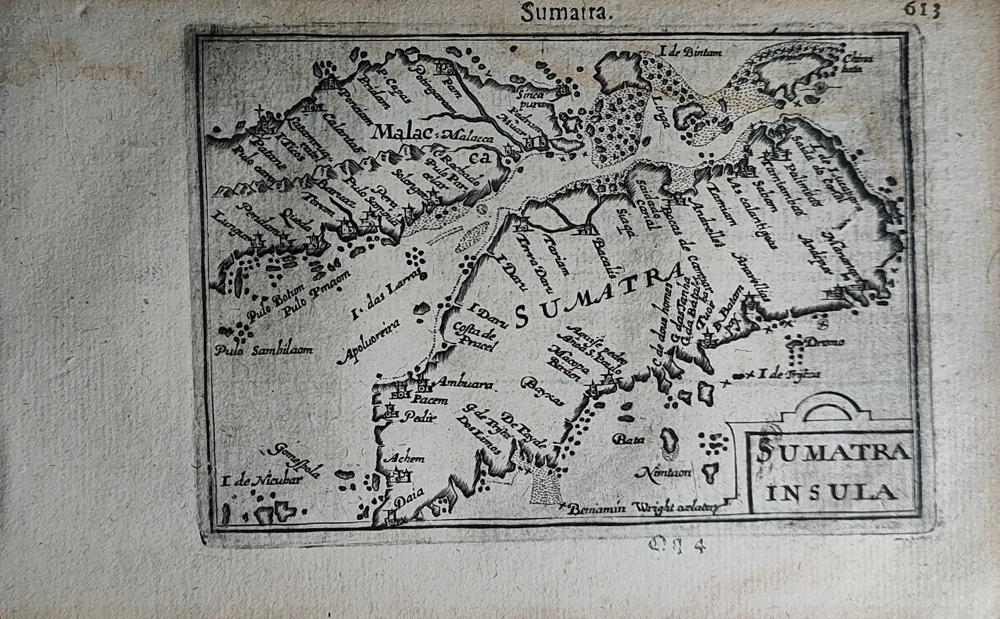
Map title
Sumatra
Author
Bertius
Location shown in map
Sumatra
Edition date
Circa 1606
Edition place
Amsterdam
Editor
Atlas
Price
300 Euro
State
[mint/EXCELLENT/very good/good/fair/mediocre/poor]
Color
Black/white
Verso
Duch text pag.614
Size
Plate: cm (12 x 9) inches (4.72 x 3.54) Paper: cm (18 x 11) inches (7.09 x 4.33)
Technique
Copper engraving
Note
Reference
Wiki
Here for more info
In stock
Available
Info
info@thetreasuremaps.com
Code
#1250
Sumatra
Author
Bertius
Location shown in map
Sumatra
Edition date
Circa 1606
Edition place
Amsterdam
Editor
Atlas
Price
300 Euro
State
[mint/EXCELLENT/very good/good/fair/mediocre/poor]
Color
Black/white
Verso
Duch text pag.614
Size
Plate: cm (12 x 9) inches (4.72 x 3.54) Paper: cm (18 x 11) inches (7.09 x 4.33)
Technique
Copper engraving
Note
Reference
Wiki
Here for more info
In stock
Available
Info
info@thetreasuremaps.com
Code
#1250
×
![Sumatra by Bertius, Sumatra, Circa 1606]()