News
Map title
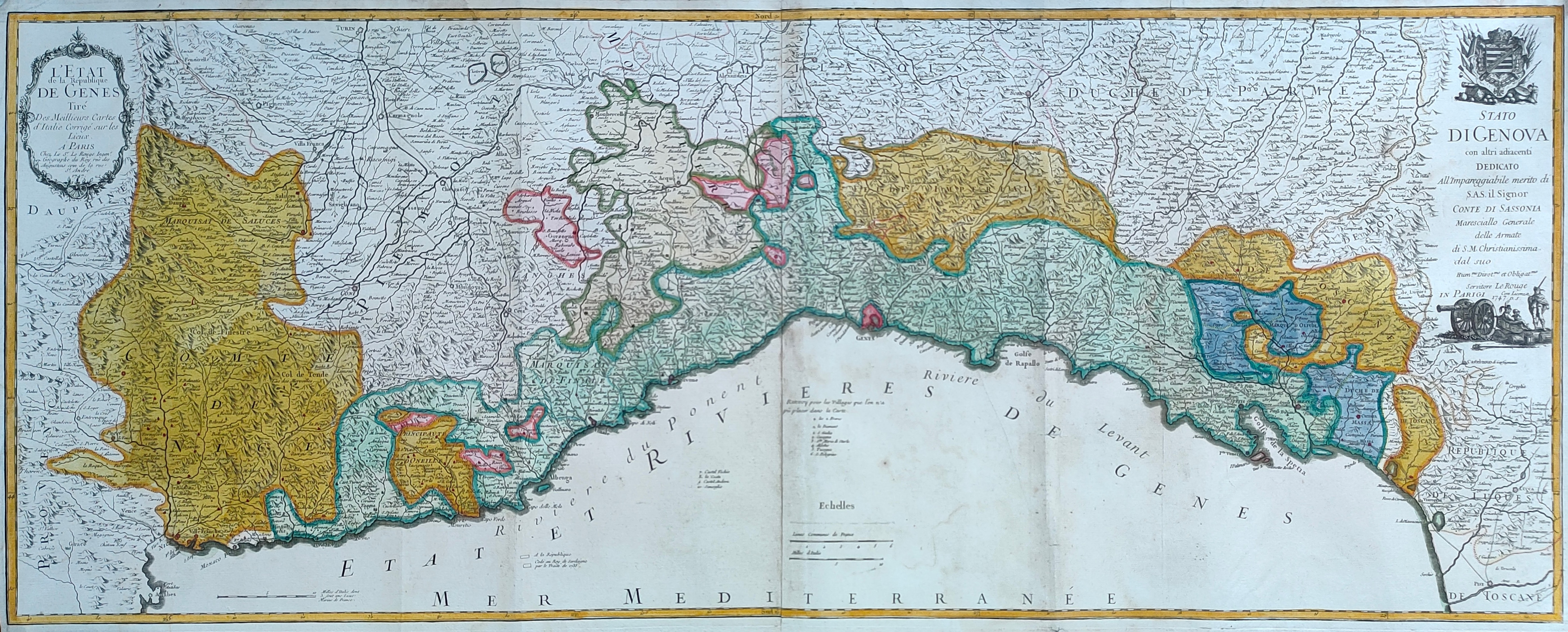
L'Etat de la republique de Genes
Author
Le Rouge
Location shown in map
Liguria
Edition date
1747
Edition place
Paris
Editor
Atlas
Price
600 Euro
State
[mint/EXCELLENT/very good/good/fair/mediocre/poor]
Color
Old colors
Verso
Blank
Size
Plate: cm (110 x 44) inches (43.31 x 17.32) Paper: cm (114 x 48) inches (44.88 x 18.9)
Technique
Copper engraving
Note
Reference
Wiki
Here for more info
In stock
Available
Info
info@thetreasuremaps.com
Code
#1245
×
![L'Etat de la republique de Genes by Le Rouge, Liguria, 1747]()
Map title
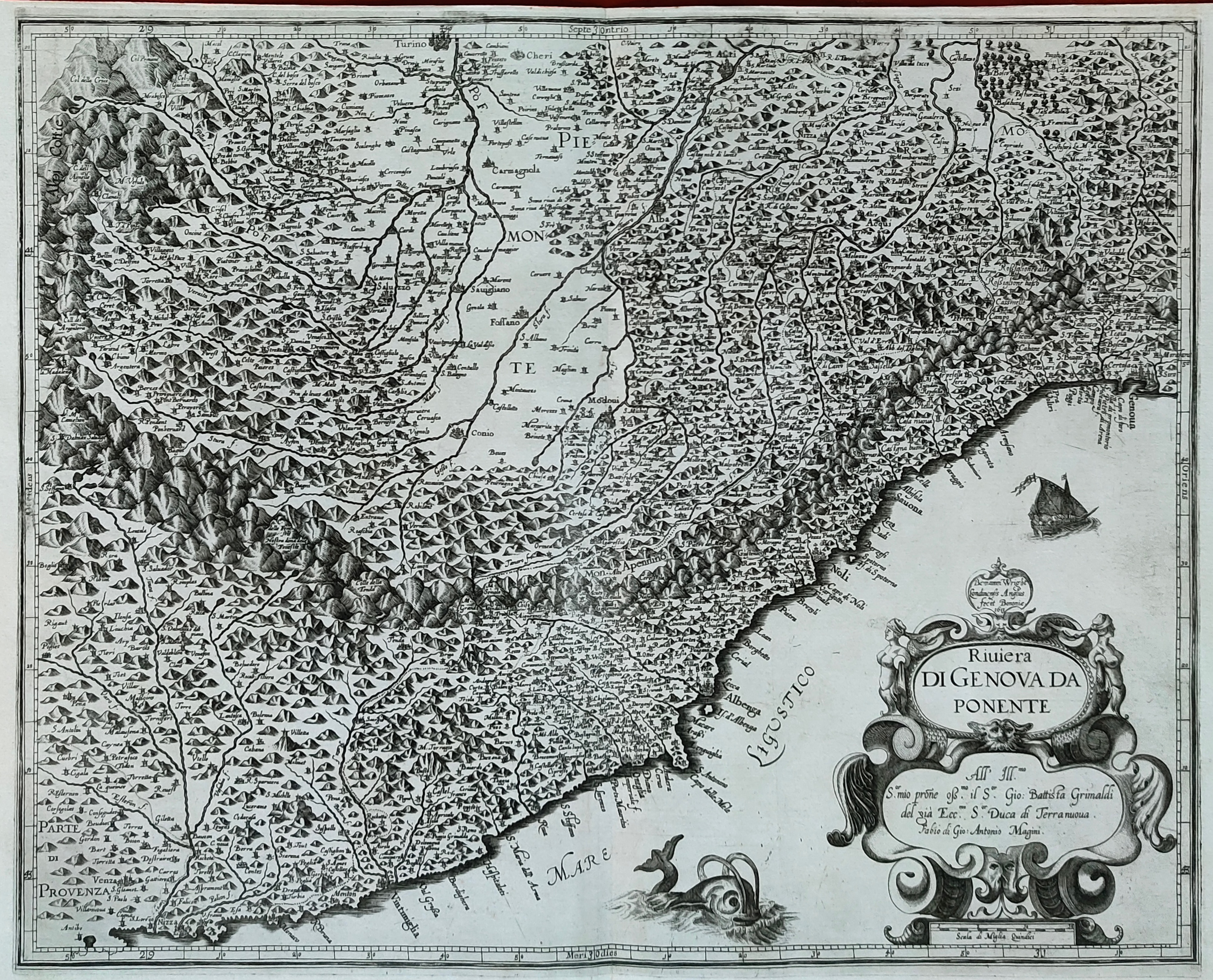
Riviera di Genova da Ponente
Author
Magini
Location shown in map
Liguria
Edition date
1620
Edition place
Bolonia
Editor
Magini
Atlas
Italia
Price
500 Euro
State
[mint/EXCELLENT/very good/good/fair/mediocre/poor]
Color
Black/white
Verso
Blank
Size
Plate: cm (48 x 38) inches (18.9 x 14.96) Paper: cm (53 x 39) inches (20.87 x 15.35)
Technique
Copper engraving
Note
Reference
--
Wiki
Here for more info
In stock
Available
Info
info@thetreasuremaps.com
Code
#1244
×
![Riviera di Genova da Ponente by Magini, Liguria, 1620]()
Map title
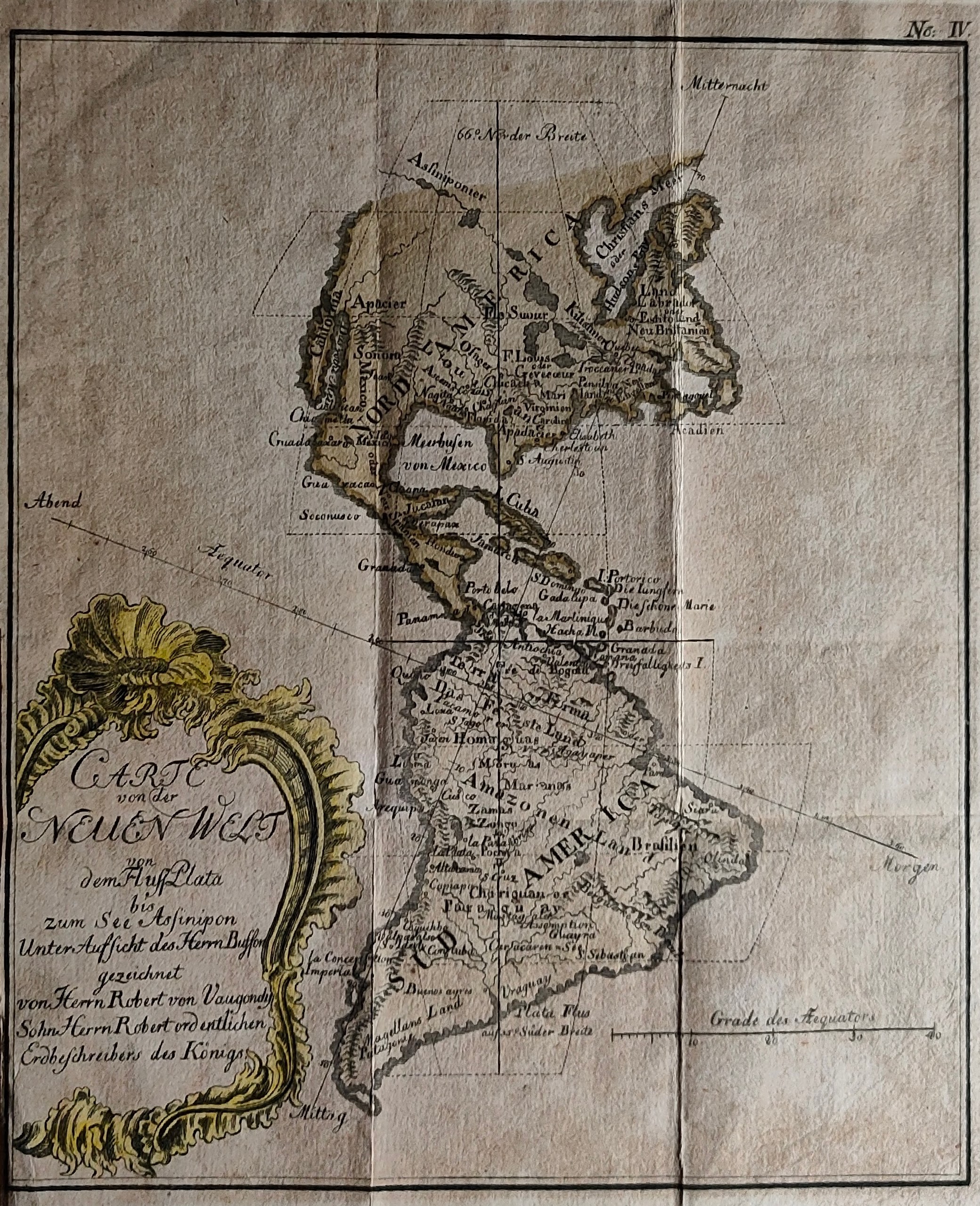
Carte von neuen welt ...
Author
Buffon
Location shown in map
All America
Edition date
1771
Edition place
Berlin
Editor
Atlas
Price
150 Euro
State
[mint/EXCELLENT/very good/good/fair/mediocre/poor]
Color
Old colors
Verso
Blank
Size
Plate: cm (18 x 22) inches (7.09 x 8.66) Paper: cm (19 x 25) inches (7.48 x 9.84)
Technique
Copper engraving
Note
Reference
Wiki
Here for more info
In stock
Available
Info
info@thetreasuremaps.com
Code
#1242
×
![Carte von neuen welt ... by Buffon, All America, 1771]()
Map title
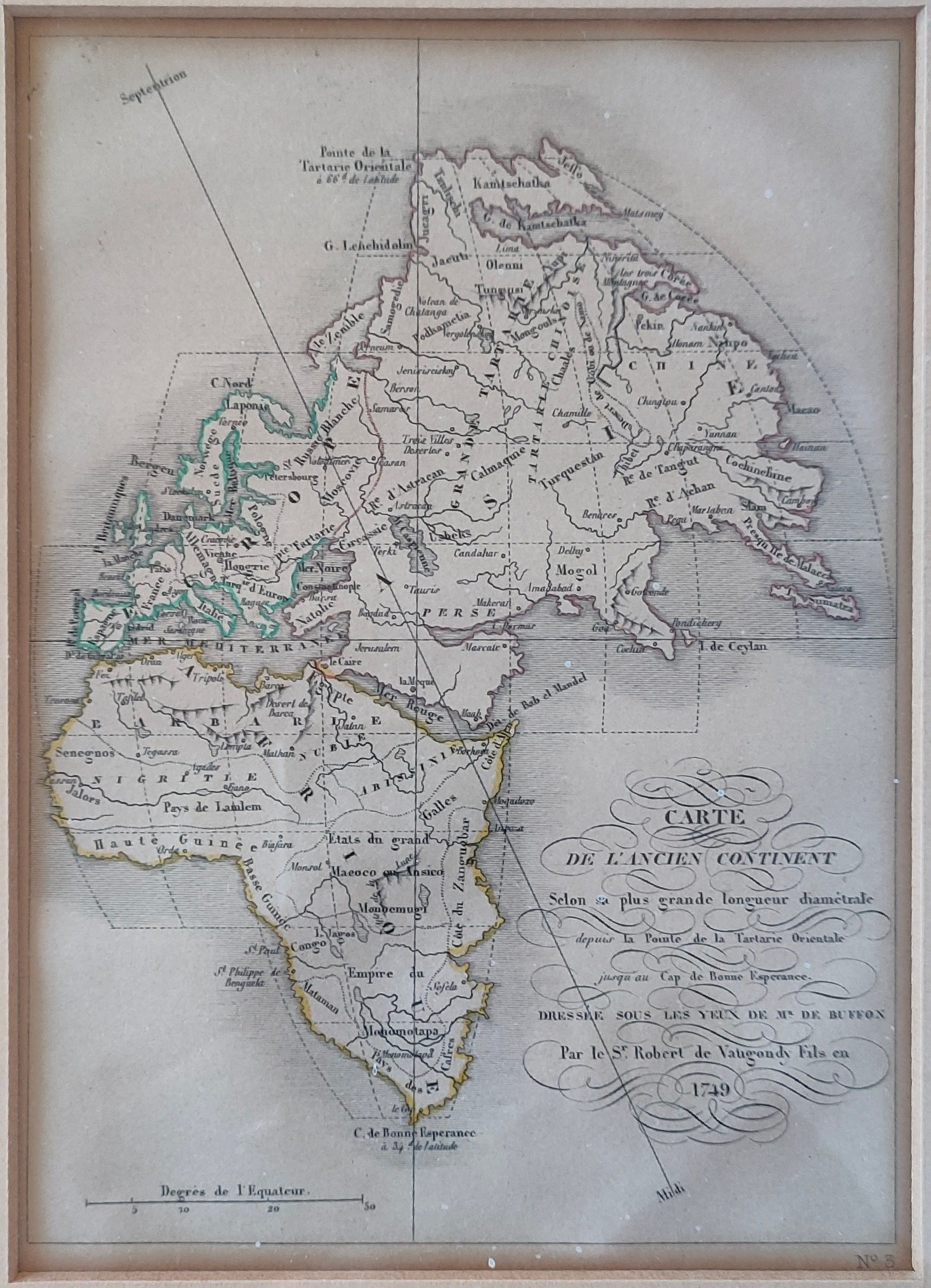
Carte du Ancient Continent...
Author
Buffon
Location shown in map
World
Edition date
Circa 1840
Edition place
Paris
Editor
Garnier Freres
Atlas
Price
75 Euro
State
[MINT/excellent/very good/good/fair/mediocre/poor]
Color
Old colors
Verso
Blank
Size
Plate: cm (15 x 20) inches (5.91 x 7.87) Paper: cm (15 x 20) inches (5.91 x 7.87)
Technique
Steel engraving
Note
framed
Reference
Wiki
Here for more info
In stock
Available
Info
info@thetreasuremaps.com
Code
#1241
×
![Carte du Ancient Continent... by Buffon, World, Circa 1840]()
Map title
Carte du Nouveau Continent...
Author
Buffon
Location shown in map
All America
Edition date
Circa 1840
Edition place
Paris
Editor
Garnier Freres
Atlas
Price
75 Euro
State
[MINT/excellent/very good/good/fair/mediocre/poor]
Color
Old colors
Verso
Blank
Size
Plate: cm (15 x 20) inches (5.91 x 7.87) Paper: cm (15 x 20) inches (5.91 x 7.87)
Technique
Steel engraving
Note
framed
Reference
Wiki
Here for more info
In stock
Available
Info
info@thetreasuremaps.com
Code
#1240
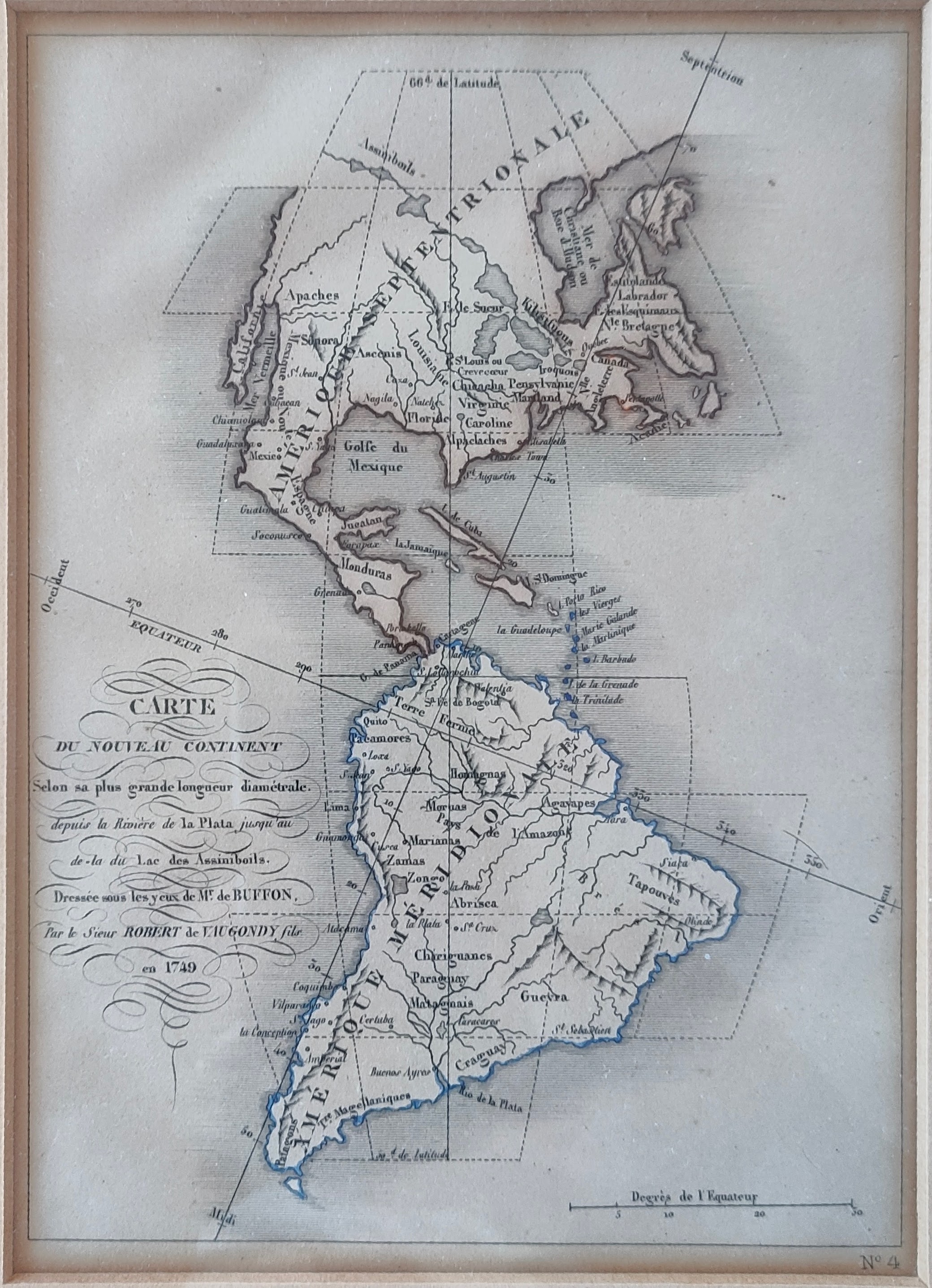
×
![Carte du Nouveau Continent... by Buffon, All America, Circa 1840]()
Map title
Genoua cita maritima
Author
Foresti
Location shown in map
Genoa
Edition date
Circa 1535
Edition place
Venice
Editor
Georgii de Rusconibus
Atlas
Supplementum supplementi cronicarum
Price
300 Euro
State
[MINT/excellent/very good/good/fair/mediocre/poor]
Color
Black/white
Verso
Italian text
Size
Plate: cm (12 x 9) inches (4.72 x 3.54) Paper: cm (20 x 29) inches (7.87 x 11.42)
Technique
Woodcut
Note
The woodcut plate dates back to 1492
Reference
--
Wiki
Here for more info
In stock
Available
Info
info@thetreasuremaps.com
Code
#1239
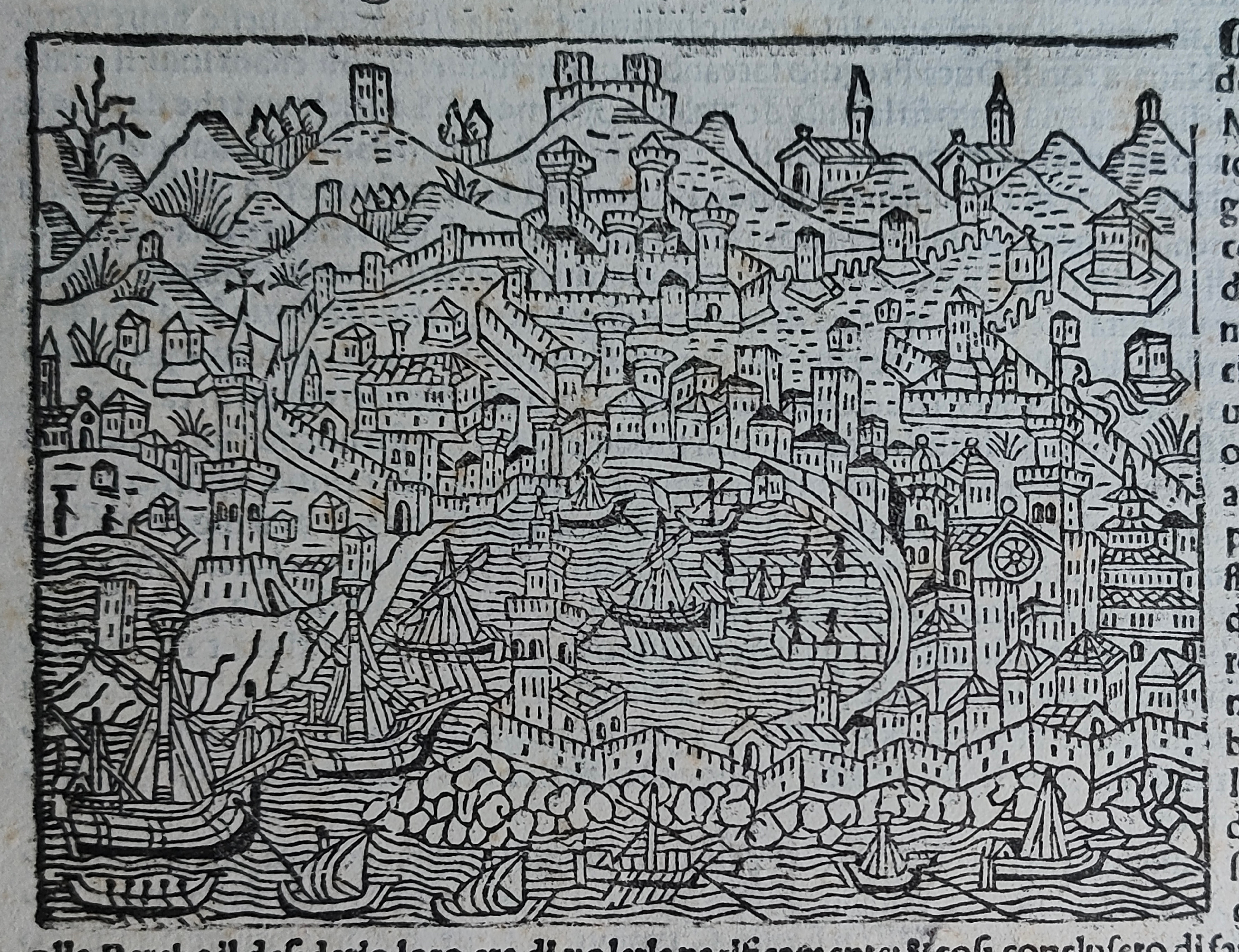
×
![Genoua cita maritima by Foresti, Genoa, Circa 1535]()
Map title
Carte Des Deux Regions Polaires
Author
Buffon
Location shown in map
Polar
Edition date
Circa 1778
Edition place
Paris
Editor
Atlas
Histoire naturelle, générale et particulière
Price
175 Euro
State
[mint/EXCELLENT/very good/good/fair/mediocre/poor]
Color
Black/white
Verso
Blank
Size
Plate: cm (44 x 22) inches (17.32 x 8.66) Paper: cm (47 x 24) inches (18.5 x 9.45)
Technique
Copper engraving
Note
Reference
Wiki
Here for more info
In stock
Available
Info
info@thetreasuremaps.com
Code
#1255
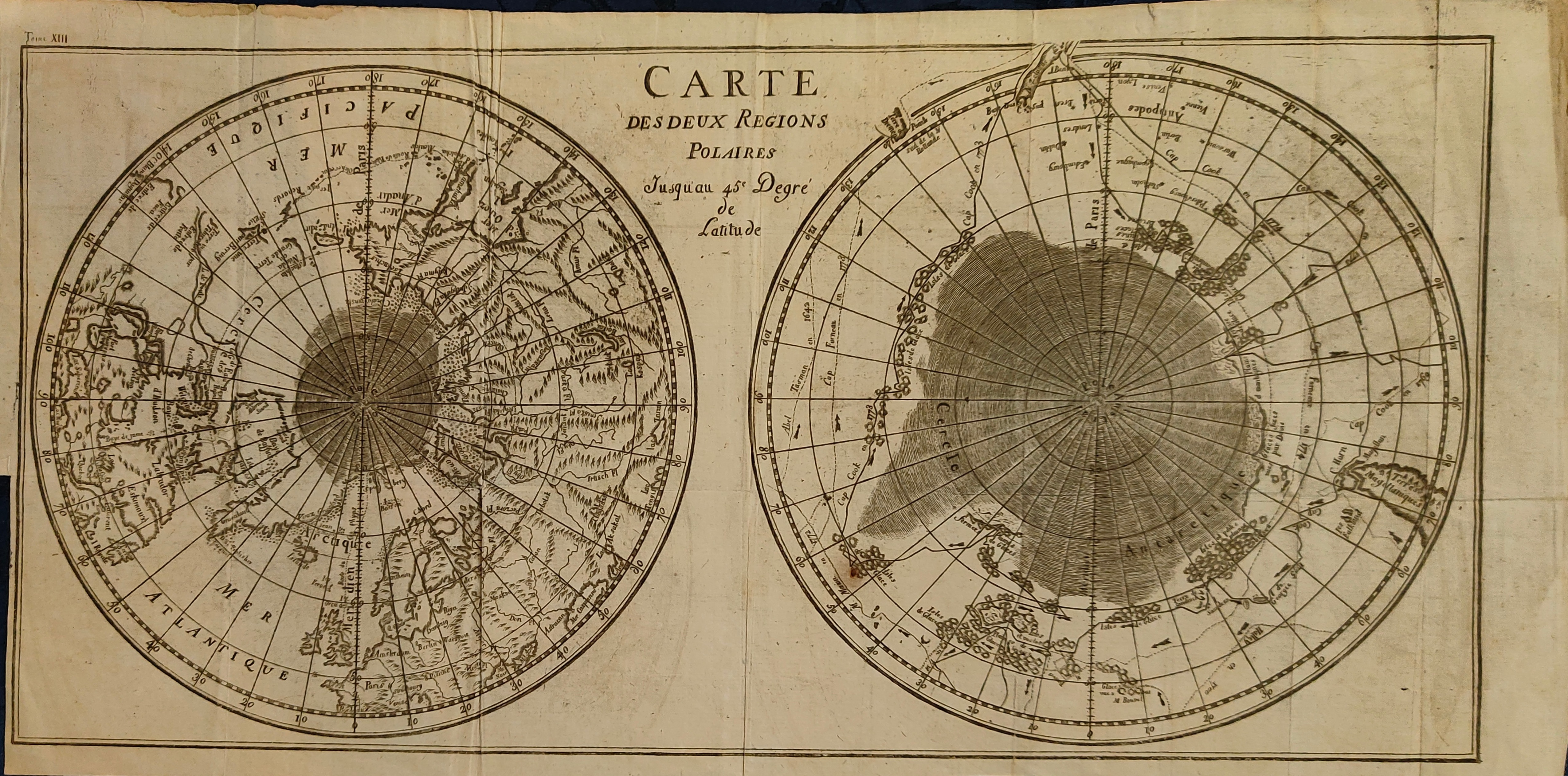
×
![Carte Des Deux Regions Polaires by Buffon, Polar, Circa 1778]()
Map title
Riviera di Genova di Levante
Author
Jansson
Location shown in map
Liguria
Edition date
Circa 1640
Edition place
Editor
Atlas
Price
500 Euro
State
[mint/excellent/VERY GOOD/good/fair/mediocre/poor]
Color
Old colors
Verso
German text
Size
Plate: cm (50 x 39) inches (19.69 x 15.35) Paper: cm (55 x 44) inches (21.65 x 17.32)
Technique
Copper engraving
Note
Reference
Wiki
Here for more info
In stock
Available
Info
info@thetreasuremaps.com
Code
#1283
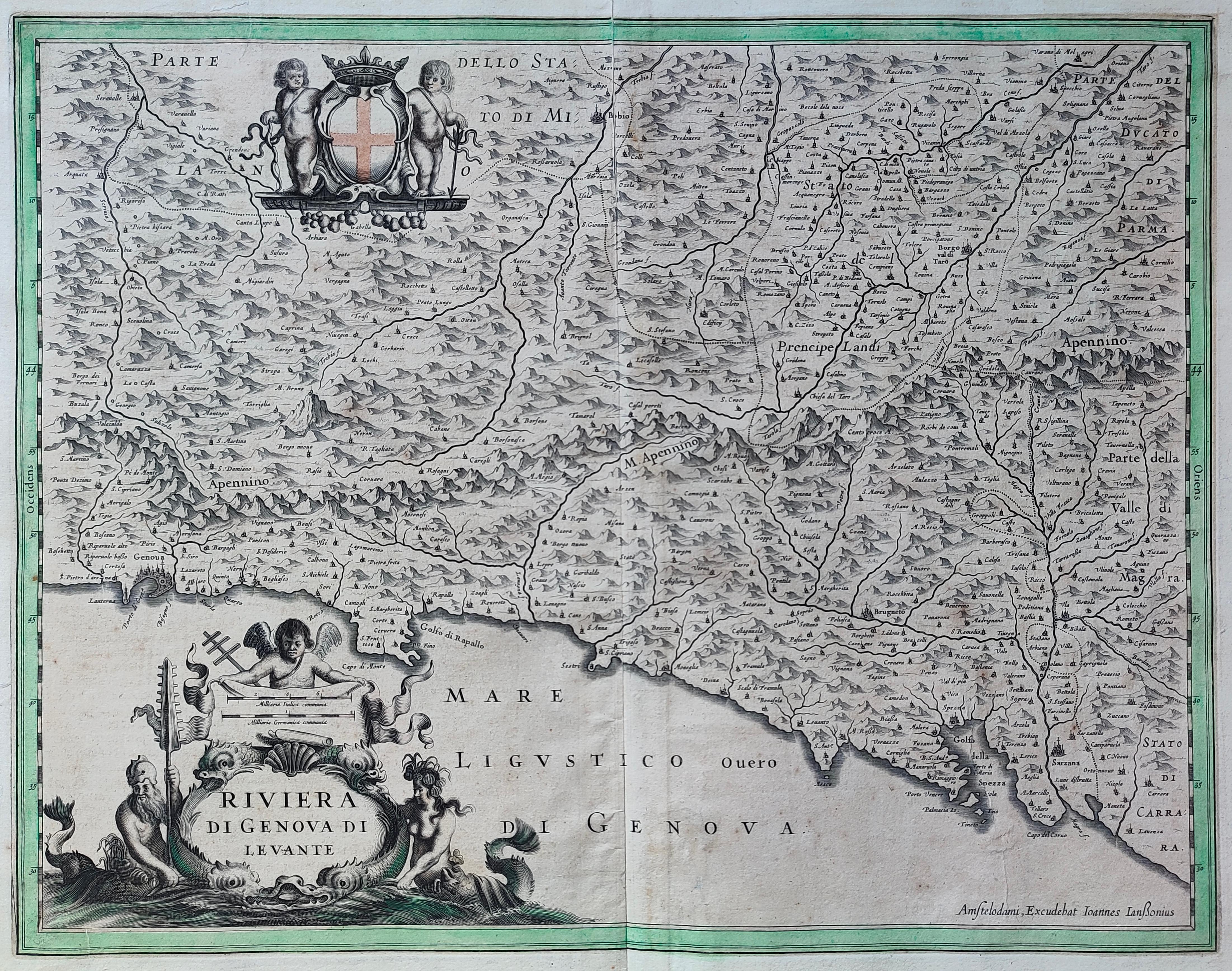
×
![Riviera di Genova di Levante by Jansson, Liguria, Circa 1640]()
Map title
Mappe-monde ou le globe terrestre
Author
Herrison
Location shown in map
World
Edition date
1816
Edition place
Paris
Editor
Basset
Atlas
Price
600 Euro
State
[mint/EXCELLENT/very good/good/fair/mediocre/poor]
Color
Old colors
Verso
Size
Plate: cm (100 x 60) inches (39.37 x 23.62) Paper: cm (100 x 60) inches (39.37 x 23.62)
Technique
Copper engraving
Note
framed
Reference
Wiki
Here for more info
In stock
Available
Info
info@thetreasuremaps.com
Code
#1225
×
![Mappe-monde ou le globe terrestre by Herrison, World, 1816]()
Map title
Carte de l'Italie
Author
Tavernier
Location shown in map
Italy
Edition date
Circa 1642
Edition place
Paris
Editor
Atlas
Price
800 Euro
State
[mint/EXCELLENT/very good/good/fair/mediocre/poor]
Color
Old colors
Verso
Blank
Size
Plate: cm (60 x 52) inches (23.62 x 20.47) Paper: cm (51 x 70) inches (20.08 x 27.56)
Technique
Copper engraving
Note
framed
Reference
R.Borri L'Italia nelle antiche carte pag.136
Wiki
Here for more info
In stock
Available
Info
info@thetreasuremaps.com
Code
#1226
×
![Carte de l'Italie by Tavernier, Italy, Circa 1642]()

Map title
Totius regni Neapolis
Author
Homann
Location shown in map
South Italy
Edition date
Circa 1716
Edition place
Nurimberg
Editor
Atlas
Price
400 Euro
State
[mint/EXCELLENT/very good/good/fair/mediocre/poor]
Color
Old colors
Verso
Blank
Size
Plate: cm (51 x 60) inches (20.08 x 23.62) Paper: cm (48 x 56) inches (18.9 x 22.05)
Technique
Copper engraving
Note
framed
Reference
--
Wiki
Here for more info
In stock
Available
Info
info@thetreasuremaps.com
Code
#1227
×
![Totius regni Neapolis by Homann, South Italy, Circa 1716]()
Map title
Persici Sive Sophorum Regni Typus
Author
Ortelius
Location shown in map
Persia
Edition date
Circa 1580
Edition place
Amsterdam
Editor
--
Atlas
Theatrum Orbis Terrarum
Price
500 Euro
State
[mint/EXCELLENT/very good/good/fair/mediocre/poor]
Color
Old colors
Verso
Size
Plate: cm (52 x 40) inches (20.47 x 15.75) Paper: cm (51 x 36) inches (20.08 x 14.17)
Technique
Copper engraving
Note
framed
Reference
Van Den Broecke 167
Wiki
Here for more info
In stock
Available
Info
info@thetreasuremaps.com
Code
#1229
×
![Persici Sive Sophorum Regni Typus by Ortelius, Persia, Circa 1580]()

Map title
Cursus Fluminis Padi vel Po per Longobardiam
Author
Homann
Location shown in map
Liguria
Edition date
1735
Edition place
Editor
Atlas
Atlas compendiarius
Price
300 Euro
State
[mint/EXCELLENT/very good/good/fair/mediocre/poor]
Color
Old colors
Verso
Blank
Size
Plate: cm (60 x 54) inches (23.62 x 21.26) Paper: cm (58 x 50) inches (22.83 x 19.69)
Technique
Copper engraving
Note
Reference
Wiki
Here for more info
In stock
Available
Info
info@thetreasuremaps.com
Code
#1228
×
![Cursus Fluminis Padi vel Po per Longobardiam by Homann, Liguria, 1735]()
Map title
Venetia, Kingdom of Italy
Author
Johnson
Location shown in map
Italy
Edition date
1863
Edition place
NewYork
Editor
--
Atlas
New Family Atlas of the World.
Price
200 Euro
State
[mint/EXCELLENT/very good/good/fair/mediocre/poor]
Color
Old colors
Verso
Blank
Size
Plate: cm (61 x 39) inches (24.02 x 15.35) Paper: cm (69 x 46) inches (27.17 x 18.11)
Technique
Steel engraving
Note
Reference
Wiki
Here for more info
In stock
Available
Info
info@thetreasuremaps.com
Code
#1230
×
![Venetia, Kingdom of Italy by Johnson, Italy, 1863]()
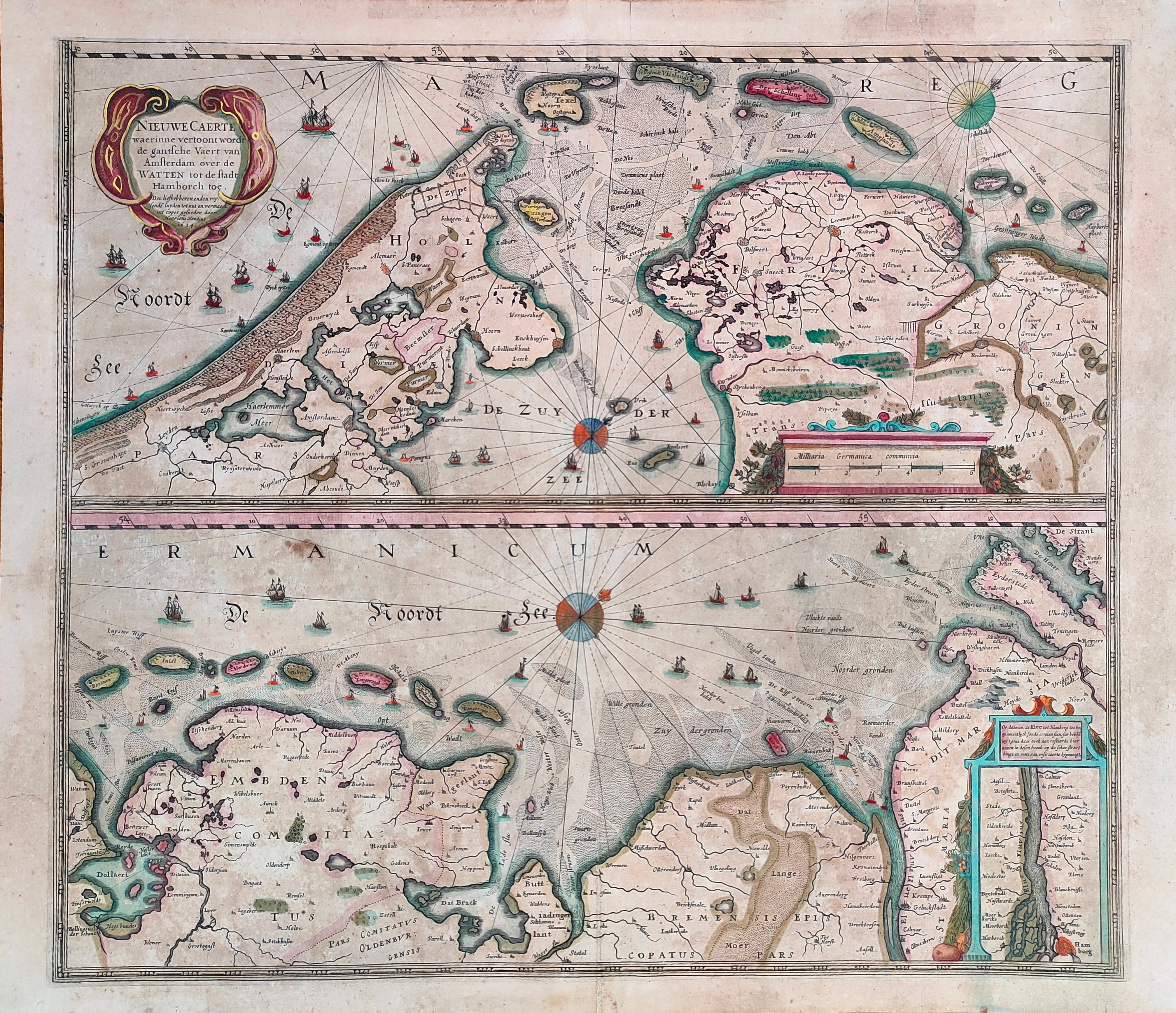
Map title
Nieuwe Caerte waerinne vertoont wordt de gantsche Vaert van Amsterdam
Author
Hondius
Location shown in map
Amsterdam
Edition date
Circa 1650
Edition place
Amsterdam
Editor
Hondius
Atlas
Price
400 Euro
State
[mint/EXCELLENT/very good/good/fair/mediocre/poor]
Color
Old colors
Verso
Size
Plate: cm (51 x 45) inches (20.08 x 17.72) Paper: cm (56 x 48) inches (22.05 x 18.9)
Technique
Copper engraving
Note
Reference
Wiki
Here for more info
In stock
Available
Info
info@thetreasuremaps.com
Code
#1231
×
![Nieuwe Caerte waerinne vertoont wordt de gantsche Vaert van Amsterdam by Hondius, Amsterdam, Circa 1650]()
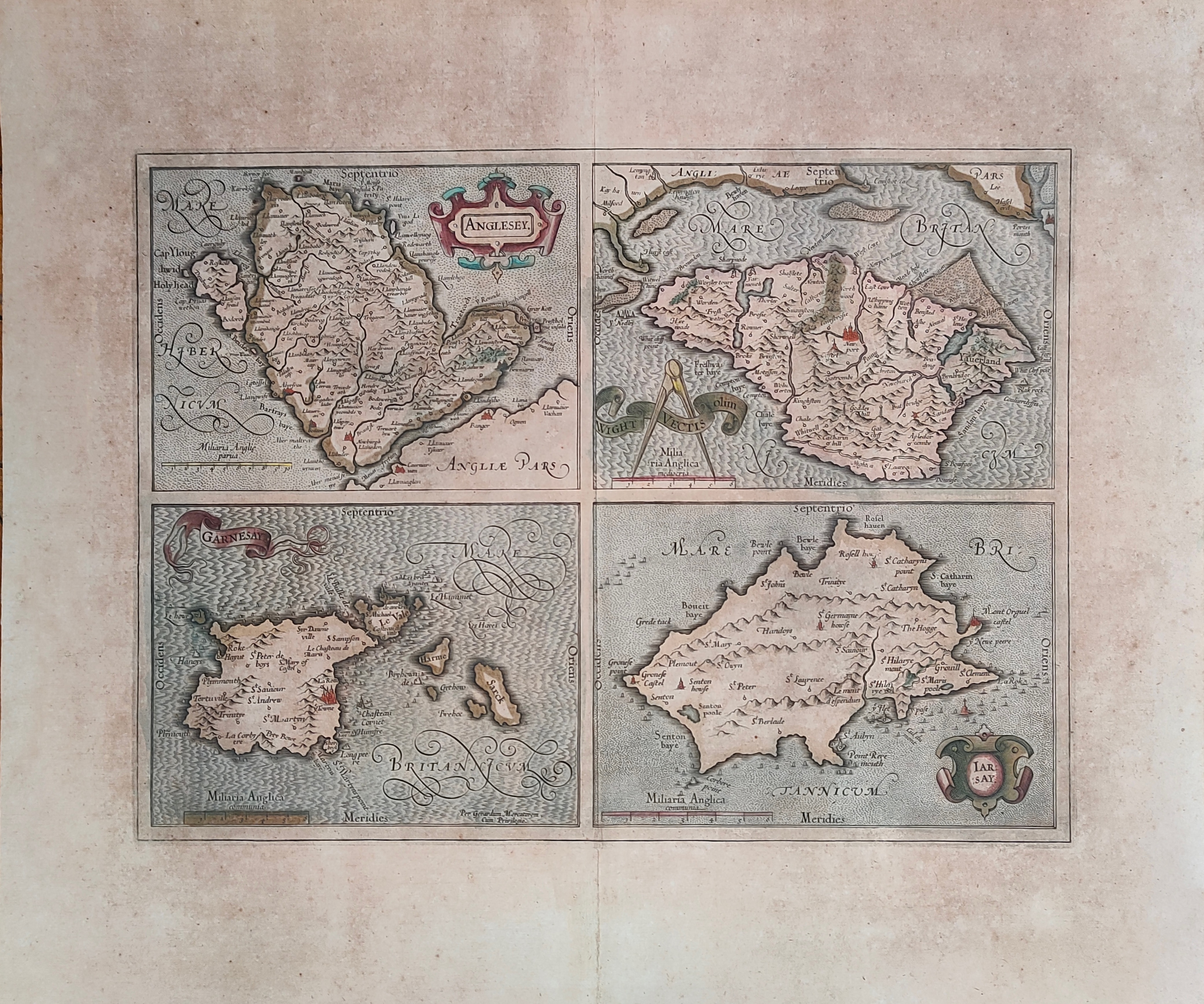
Map title
Anglesey, Garnesay, Wight olim Vectis, Iarsay
Author
Mercator
Location shown in map
Wight
Edition date
Circa 1628
Edition place
Amsterdam
Editor
Houndius
Atlas
Mercator-Hondius Atlas.
Price
250 Euro
State
[mint/EXCELLENT/very good/good/fair/mediocre/poor]
Color
Old colors
Verso
Latin text
Size
Plate: cm (42 x 32) inches (16.54 x 12.6) Paper: cm (55 x 47) inches (21.65 x 18.5)
Technique
Copper engraving
Note
Professionally repaired
Reference
Wiki
Here for more info
In stock
Available
Info
info@thetreasuremaps.com
Code
#1232
×
![Anglesey, Garnesay, Wight olim Vectis, Iarsay by Mercator, Wight, Circa 1628]()
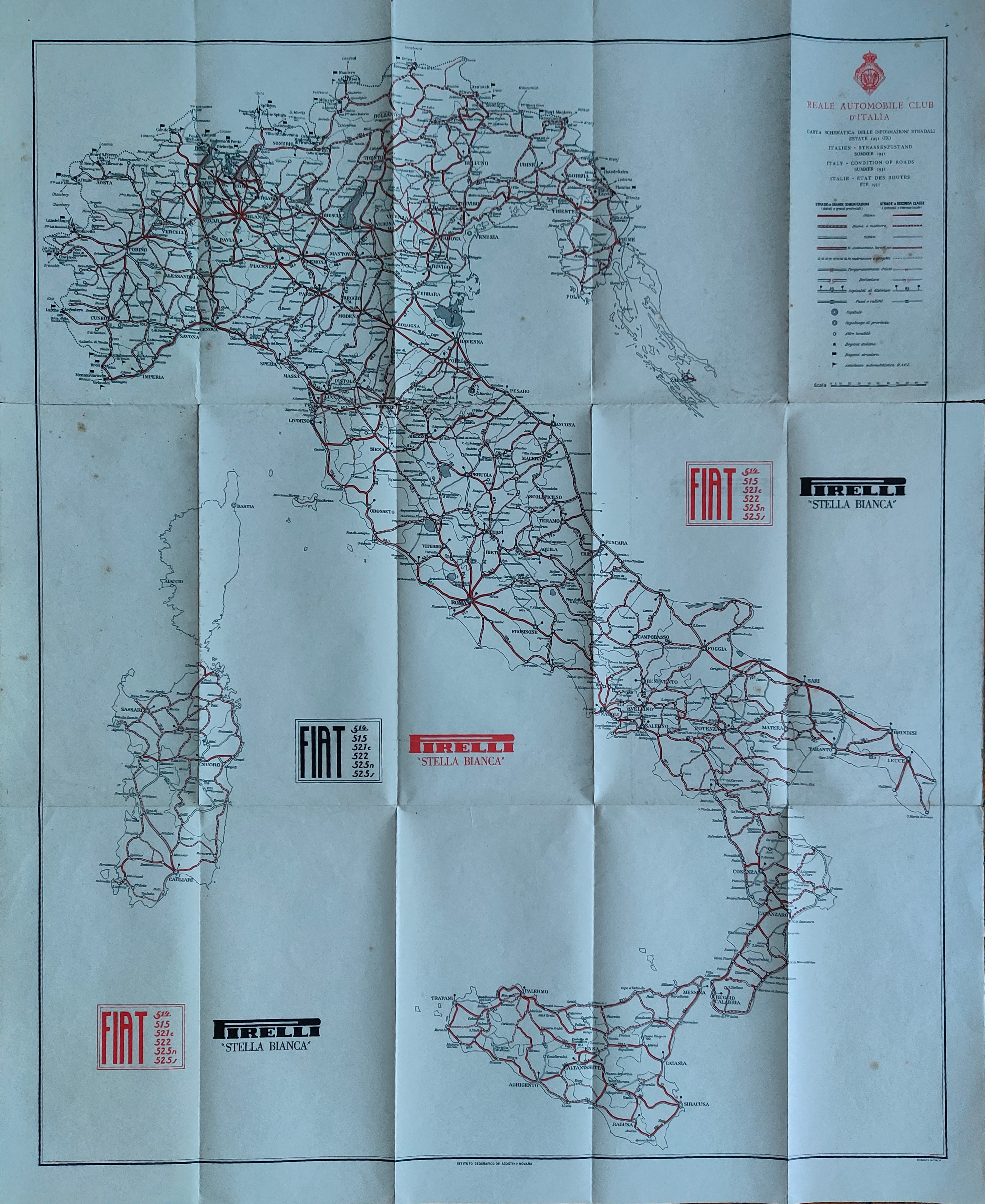
Map title
Reale Automobil club d'Italia
Author
Location shown in map
Italy
Edition date
1935
Edition place
Novara
Editor
De Agostini
Atlas
Price
200 Euro
State
[mint/EXCELLENT/very good/good/fair/mediocre/poor]
Color
Old colors
Verso
Blank
Size
Plate: cm (60 x 75) inches (23.62 x 29.53) Paper: cm (66 x 82) inches (25.98 x 32.28)
Technique
Steel engraving
Note
Reference
Wiki
Here for more info
In stock
Available
Info
info@thetreasuremaps.com
Code
#1235
×
![Reale Automobil club d'Italia by , Italy, 1935]()
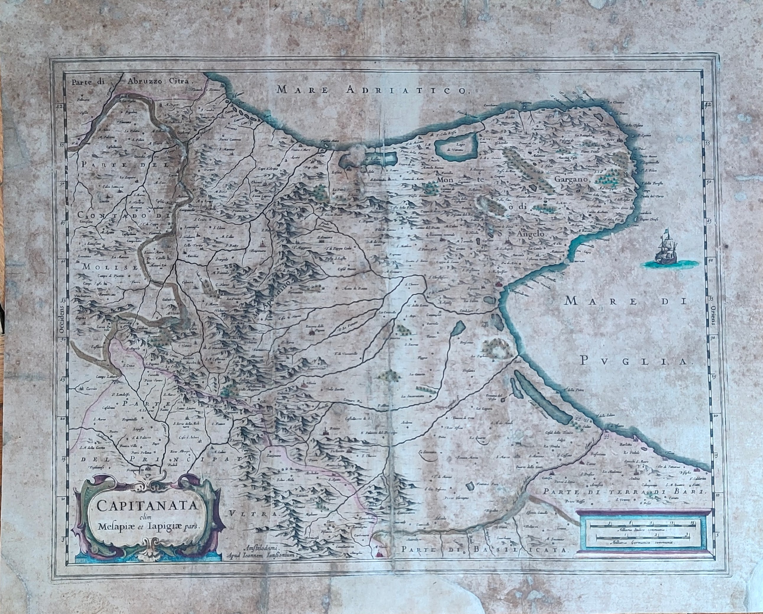
Map title
Capitanata olim Mesapiae et Iapigiae pars
Author
Jansson
Location shown in map
Puglia
Edition date
Circa 1640
Edition place
Amsterdam
Editor
Atlas
Atlas Novus
Price
200 Euro
State
[mint/excellent/very good/good/fair/mediocre/POOR]
Color
Old colors
Verso
Latin text
Size
Plate: cm (49 x 37) inches (19.29 x 14.57) Paper: cm (55 x 44) inches (21.65 x 17.32)
Technique
Copper engraving
Note
Reference
Wiki
Here for more info
In stock
Available
Info
info@thetreasuremaps.com
Code
#1294
×
![Capitanata olim Mesapiae et Iapigiae pars by Jansson, Puglia, Circa 1640]()
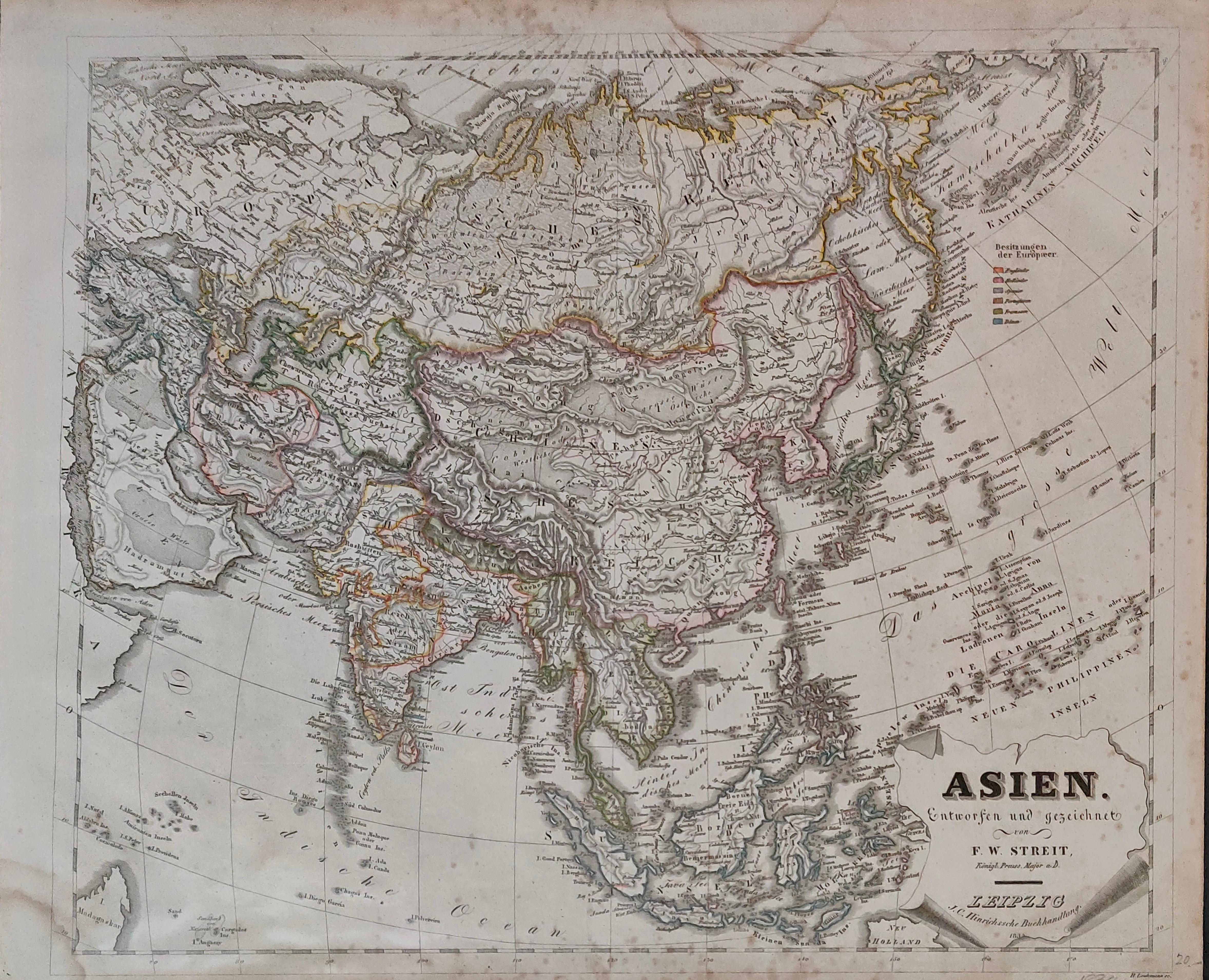
Map title
Asien
Author
Streit
Location shown in map
Asia
Edition date
1834
Edition place
Leipzing
Editor
Atlas
Price
75 Euro
State
[mint/excellent/VERY GOOD/good/fair/mediocre/poor]
Color
Old colors
Verso
Blank
Size
Plate: cm (47 x 40) inches (18.5 x 15.75) Paper: cm (50 x 42) inches (19.69 x 16.54)
Technique
Steel engraving
Note
Reference
Wiki
Here for more info
In stock
Available
Info
info@thetreasuremaps.com
Code
#1256
×
![Asien by Streit, Asia, 1834]()

Map title
Descriptio Fluminum Rheni, Vahalis et Mosae a Rheno Berca ad Goricomium usque
Author
Hondius
Location shown in map
Rhine
Edition date
Circa 1642
Edition place
Amsterdam
Editor
Hondius
Atlas
Price
175 Euro
State
[mint/EXCELLENT/very good/good/fair/mediocre/poor]
Color
Old colors
Verso
Latin text
Size
Plate: cm (49 x 37) inches (19.29 x 14.57) Paper: cm (56 x 48) inches (22.05 x 18.9)
Technique
Copper engraving
Note
Professionally repaired
Reference
Wiki
Here for more info
In stock
Available
Info
info@thetreasuremaps.com
Code
#1233
×
![Descriptio Fluminum Rheni, Vahalis et Mosae a Rheno Berca ad Goricomium usque by Hondius, Rhine, Circa 1642]()