All Africa
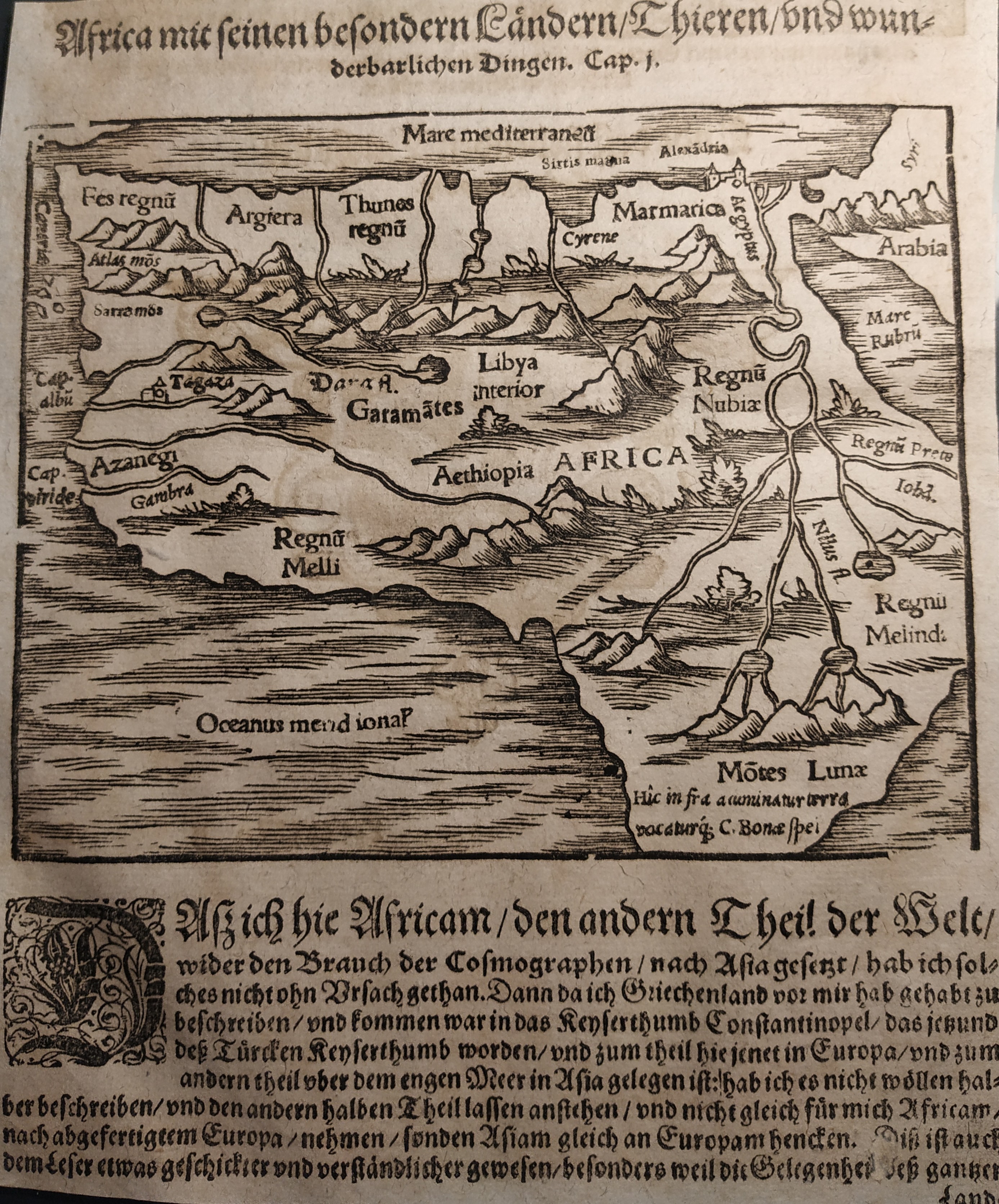
Map title
Africa
Author
Munster
Location shown in map
Africa
Edition date
Circa 1550
Edition place
Basel
Editor
Henrich Petri
Atlas
Cosmographia Universalis
Price
150 Euro
State
[mint/EXCELLENT/very good/good/fair/mediocre/poor]
Color
Black/white
Verso
German text
Size
Plate: cm (16 x 13) inches (6.3 x 5.12) Paper: cm (17 x 21) inches (6.69 x 8.27)
Technique
Woodcut
Note
No particular notes for this maps
Reference
Wiki
Here for more info
In stock
Available
Info
info@thetreasuremaps.com
Code
#0737
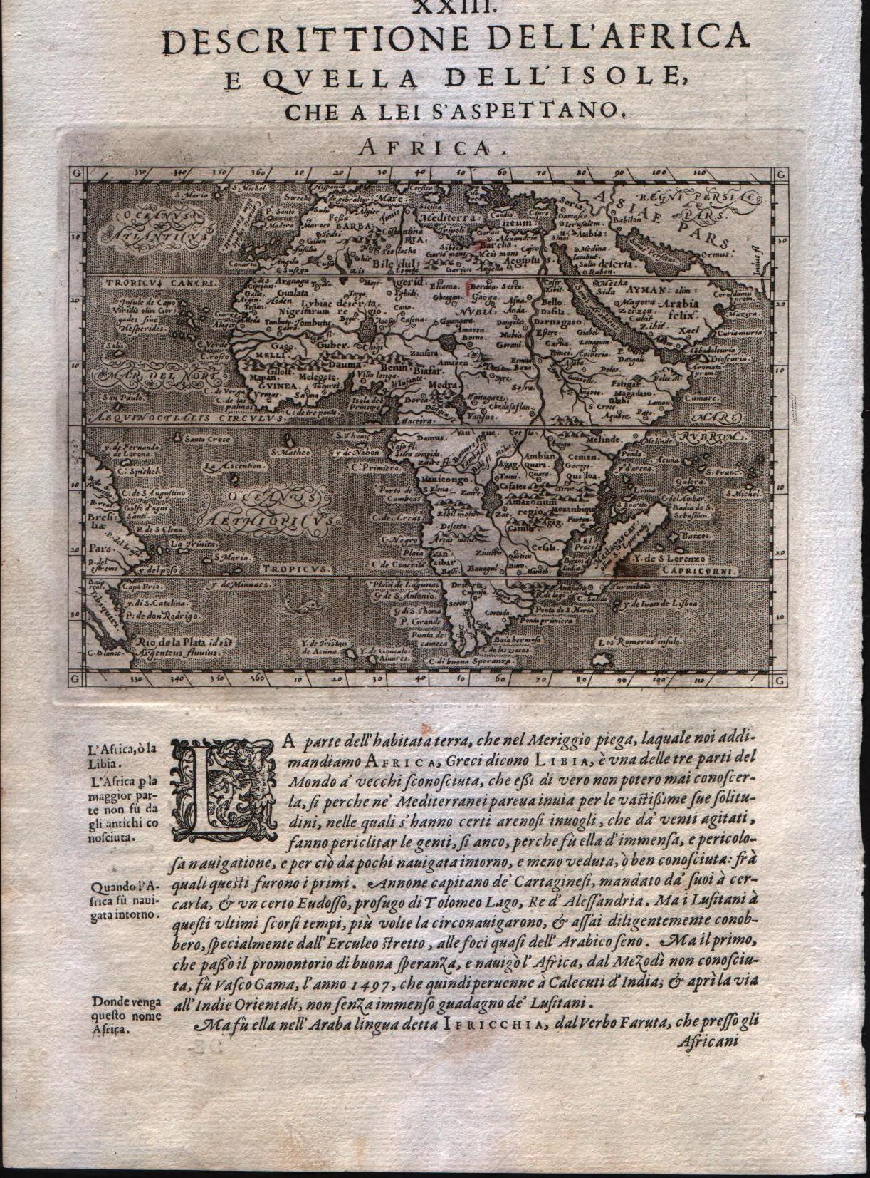
Africa
Author
Munster
Location shown in map
Africa
Edition date
Circa 1550
Edition place
Basel
Editor
Henrich Petri
Atlas
Cosmographia Universalis
Price
150 Euro
State
[mint/EXCELLENT/very good/good/fair/mediocre/poor]
Color
Black/white
Verso
German text
Size
Plate: cm (16 x 13) inches (6.3 x 5.12) Paper: cm (17 x 21) inches (6.69 x 8.27)
Technique
Woodcut
Note
No particular notes for this maps
Reference
Wiki
Here for more info
In stock
Available
Info
info@thetreasuremaps.com
Code
#0737
×
![Africa by Munster, Africa, Circa 1550]()
Map title
Africa
Author
Magini
Location shown in map
Africa
Edition date
1598
Edition place
Venice
Editor
Battista & Giorgio Galignani
Atlas
Geografia di Claudio Tolomeo -- Giovanni Antonio Magini
Price
350 Euro
State
[MINT/excellent/very good/good/fair/mediocre/poor]
Color
Black/white
Verso
Italian text pag.130
Size
Plate: cm (12.7 x 17.8) inches (5 x 7.01) Paper: cm (20.3 x 30.5) inches (7.99 x 12.01)
Technique
Copper engraving
Note
No particular notes for this maps
Reference
--
Wiki
Here for more info
In stock
Available
Info
info@thetreasuremaps.com
Code
#0290
Africa
Author
Magini
Location shown in map
Africa
Edition date
1598
Edition place
Venice
Editor
Battista & Giorgio Galignani
Atlas
Geografia di Claudio Tolomeo -- Giovanni Antonio Magini
Price
350 Euro
State
[MINT/excellent/very good/good/fair/mediocre/poor]
Color
Black/white
Verso
Italian text pag.130
Size
Plate: cm (12.7 x 17.8) inches (5 x 7.01) Paper: cm (20.3 x 30.5) inches (7.99 x 12.01)
Technique
Copper engraving
Note
No particular notes for this maps
Reference
--
Wiki
Here for more info
In stock
Available
Info
info@thetreasuremaps.com
Code
#0290
×
![Africa by Magini, Africa, 1598]()
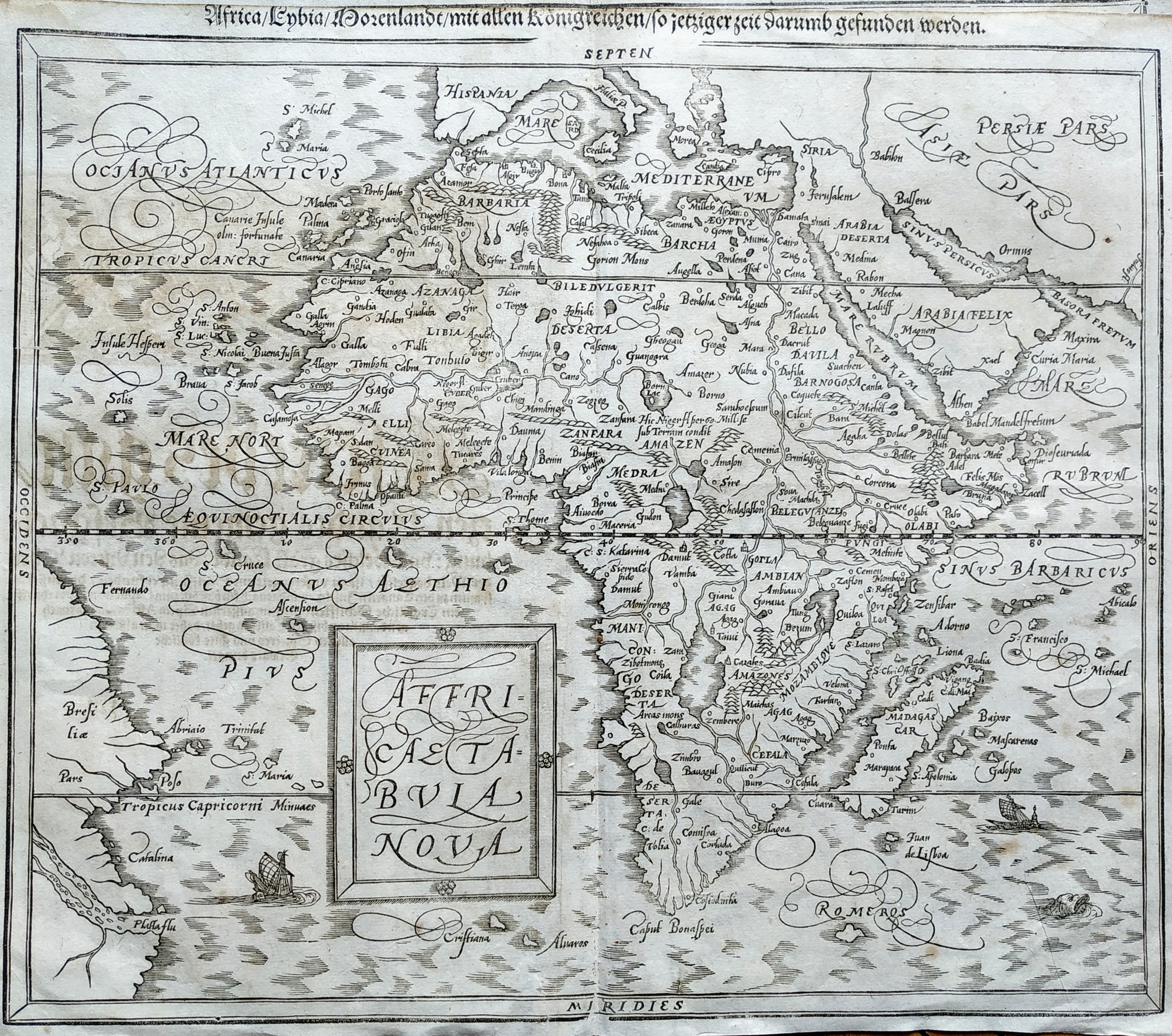
Map title
Africa Tabula Nova
Author
Munster
Location shown in map
Africa
Edition date
1598
Edition place
Basel
Editor
Henrich Petri
Atlas
Cosmographia Universalis
Price
400 Euro
State
[mint/excellent/VERY GOOD/good/fair/mediocre/poor]
Color
Black/white
Verso
German text
Size
Plate: cm (36 x 31) inches (14.17 x 12.2) Paper: cm (38 x 33) inches (14.96 x 12.99)
Technique
Woodcut
Note
No particular notes for this maps
Reference
--
Wiki
Here for more info
In stock
Available
Info
info@thetreasuremaps.com
Code
#0732
×
![Africa Tabula Nova by Munster, Africa, 1598]()
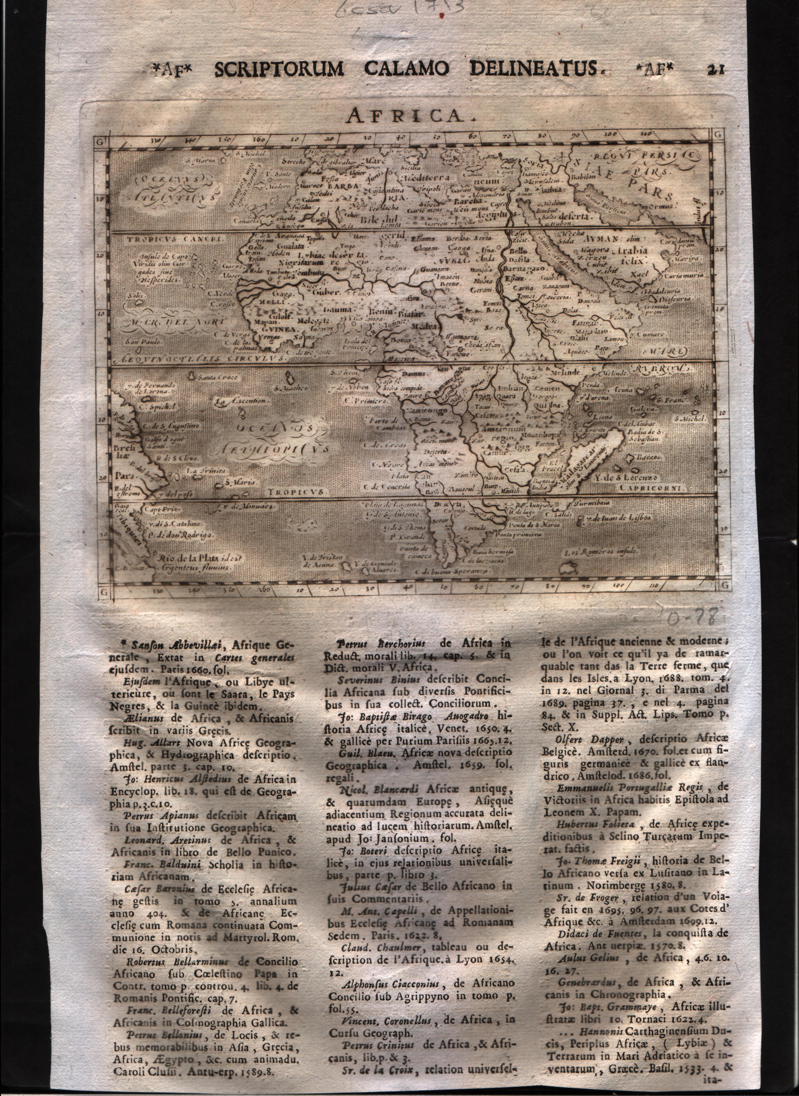
Map title
Africa
Author
Magini
Location shown in map
Africa
Edition date
1713
Edition place
Padua
Editor
Cadorin
Atlas
Universus terrarum orbis scriptorum calamo delineatus
Price
300 Euro
State
[MINT/excellent/very good/good/fair/mediocre/poor]
Color
Black/white
Verso
Latin text pag.22
Size
Plate: cm (17.8 x 12.7) inches (7.01 x 5) Paper: cm (20.3 x 30.5) inches (7.99 x 12.01)
Technique
Copper engraving
Note
Alphonse Lasor a Varea
Reference
--
Wiki
Here for more info
In stock
Available
Info
info@thetreasuremaps.com
Code
#0595
Africa
Author
Magini
Location shown in map
Africa
Edition date
1713
Edition place
Padua
Editor
Cadorin
Atlas
Universus terrarum orbis scriptorum calamo delineatus
Price
300 Euro
State
[MINT/excellent/very good/good/fair/mediocre/poor]
Color
Black/white
Verso
Latin text pag.22
Size
Plate: cm (17.8 x 12.7) inches (7.01 x 5) Paper: cm (20.3 x 30.5) inches (7.99 x 12.01)
Technique
Copper engraving
Note
Alphonse Lasor a Varea
Reference
--
Wiki
Here for more info
In stock
Available
Info
info@thetreasuremaps.com
Code
#0595
×
![Africa by Magini, Africa, 1713]()
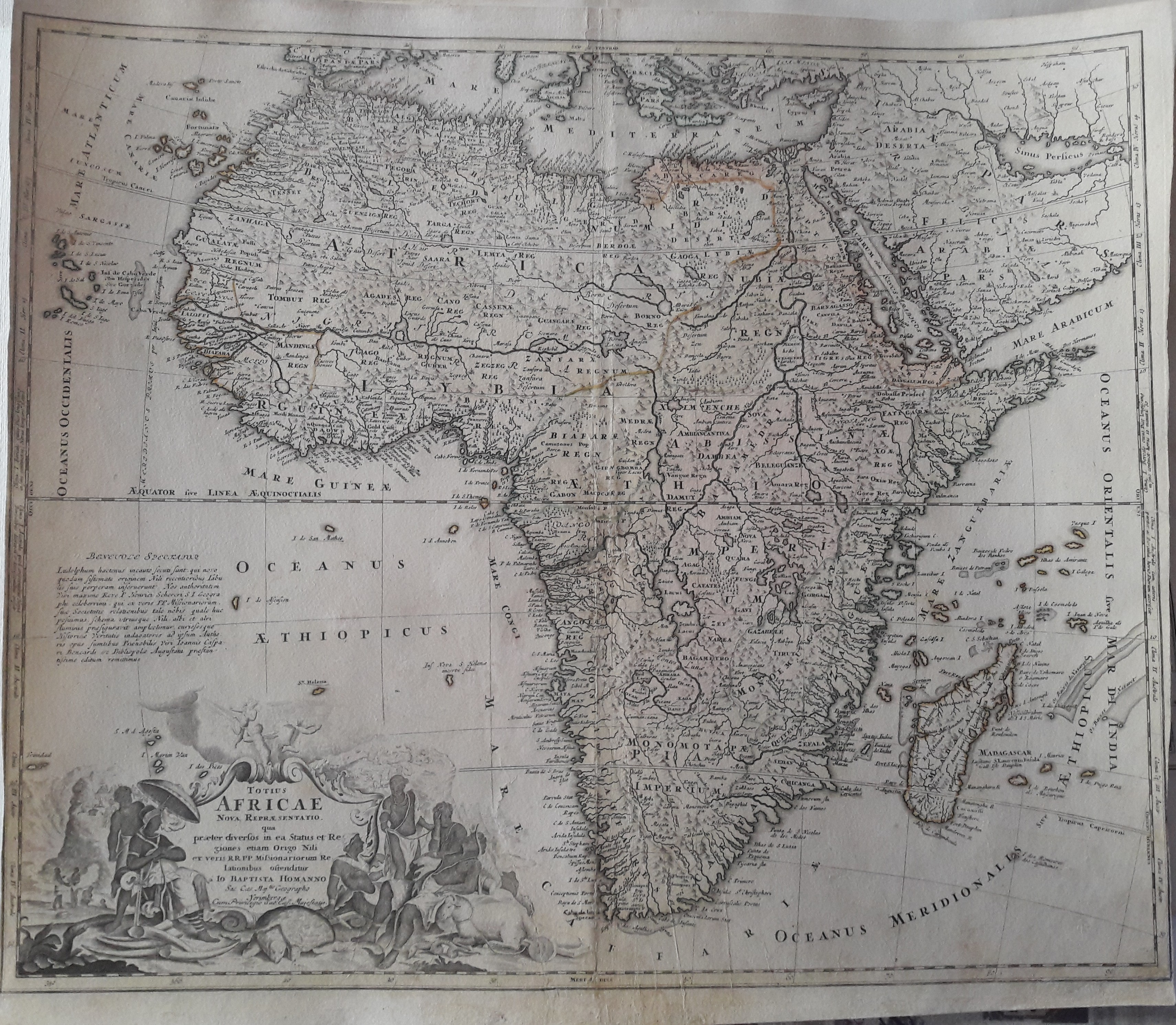
Map title
Totius Africae Nova Repraesentatio qua per diversos in ea Status et Regiones, etiam Origo Nili ex veris R.R.P.P. Missionariorum Relationibus ostenditur
Author
Homann
Location shown in map
Africa
Edition date
1720
Edition place
Nuremberg
Editor
--
Atlas
--
Price
300 Euro
State
[mint/excellent/very good/good/FAIR/mediocre/poor]
Color
Old color
Verso
Blank
Size
Plate: cm (55.9 x 48.3) inches (22.01 x 19.02) Paper: cm (57.2 x 50.8) inches (22.52 x 20)
Technique
Copper engraving
Note
Some professional repaired tears. Missing rigth bottom corner 2mm
Reference
--
Wiki
Here for more info
In stock
Available
Info
info@thetreasuremaps.com
Code
#0327
×
![Totius Africae Nova Repraesentatio qua per diversos in ea Status et Regiones, etiam Origo Nili ex veris R.R.P.P. Missionariorum Relationibus ostenditur by Homann, Africa, 1720]()
Map title
Africa
Author
Sanson
Location shown in map
Africa
Edition date
Circa 1720
Edition place
Editor
Atlas
Price
125 Euro
State
[mint/EXCELLENT/very good/good/fair/mediocre/poor]
Color
Black/white
Verso
Blank
Size
Plate: cm (16.5 x 15) inches (6.5 x 5.91) Paper: cm (21 x 19) inches (8.27 x 7.48)
Technique
Copper engraving
Note
Reference
--
Wiki
Here for more info
In stock
Available
Info
info@thetreasuremaps.com
Code
#1141
Africa
Author
Sanson
Location shown in map
Africa
Edition date
Circa 1720
Edition place
Editor
Atlas
Price
125 Euro
State
[mint/EXCELLENT/very good/good/fair/mediocre/poor]
Color
Black/white
Verso
Blank
Size
Plate: cm (16.5 x 15) inches (6.5 x 5.91) Paper: cm (21 x 19) inches (8.27 x 7.48)
Technique
Copper engraving
Note
Reference
--
Wiki
Here for more info
In stock
Available
Info
info@thetreasuremaps.com
Code
#1141
×
![Africa by Sanson, Africa, Circa 1720]()
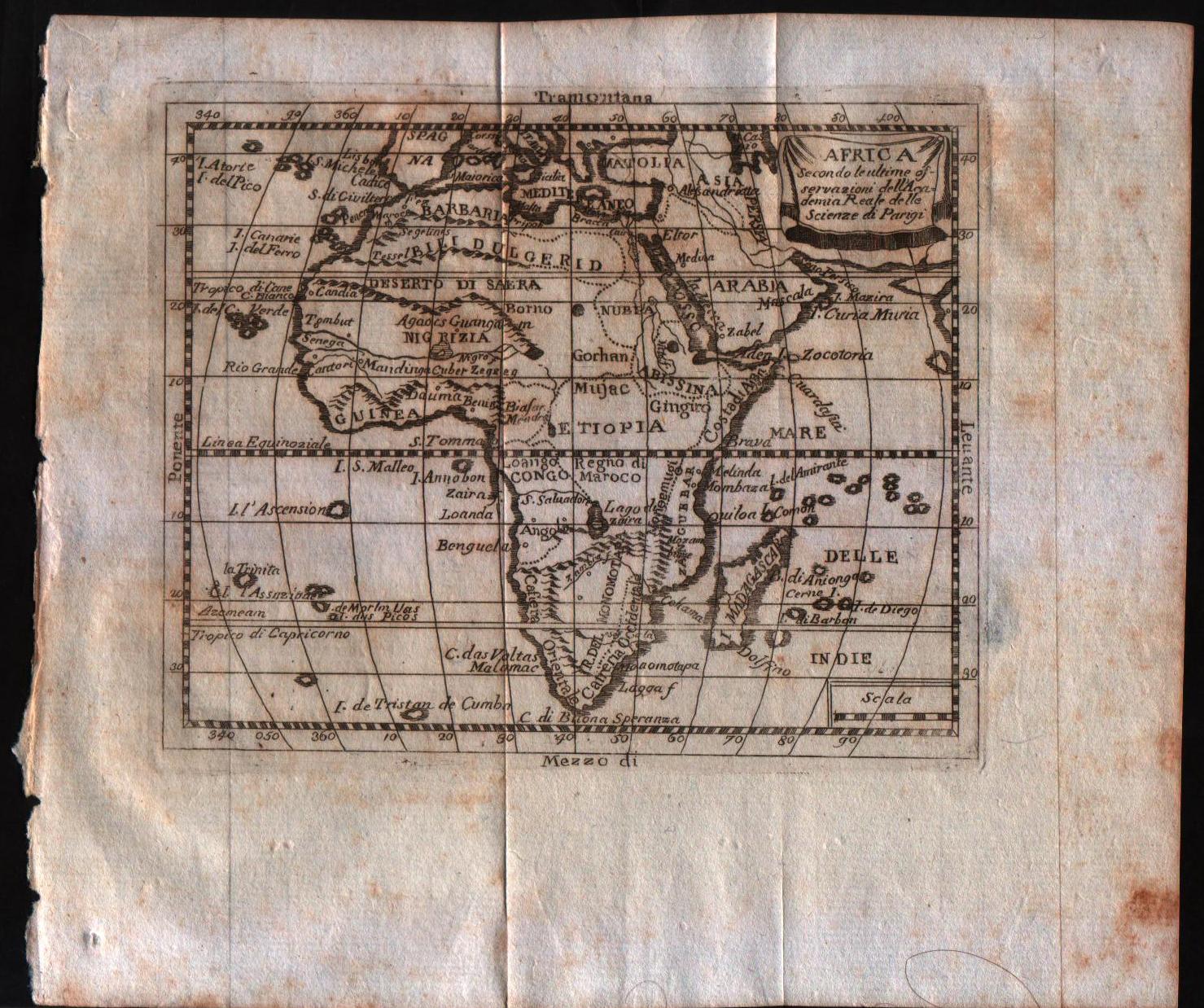
Map title
Africa, secondo le ultime osservazioni dell'accademia reale delle scienze
Author
Buffier
Location shown in map
Africa
Edition date
1790
Edition place
Rome
Editor
--
Atlas
Geographie universelle, italian edition.
Price
125 Euro
State
[mint/EXCELLENT/very good/good/fair/mediocre/poor]
Color
Black/white
Verso
Blank
Size
Plate: cm (17.8 x 14) inches (7.01 x 5.51) Paper: cm (24.1 x 20.3) inches (9.49 x 7.99)
Technique
Copper engraving
Note
Claude Buffier was a Jesuit theologian and geographer working in Paris, who wrote the Geographie Universelle, first issued in about 1715. The Geographie was issued as a pocket-sized volume, illustrated with a set of maps.The volume proved very popular, and numerous editions were published in Paris, Naples and Rome. The book was evidently targeted at the popular market, and for this reason examples of the book tend to be printed on relatively poor quality paper, and this is particularly true of the Italian editions.Evidently there were a large number of different sets of map plates used - so far 17 different plates or states of plates have been identified for the Americas map, some engraved anonymously, and other signed by Hendrick van Loon, Faure, Denise Macquart and Dom. Dell'Acerra Unfortunately, it has been frequent practice to disperse such volumes, so the origin of several of these plates has not yet been identified, and the editor would be grateful to hear from readers about editions of the book, particularly those containing maps engraved by Denise Macquart and Dom. Dell'Acerra.
Reference
--
Wiki
Here for more info
In stock
Available
Info
info@thetreasuremaps.com
Code
#0298
×
![Africa, secondo le ultime osservazioni dell'accademia reale delle scienze by Buffier, Africa, 1790]()
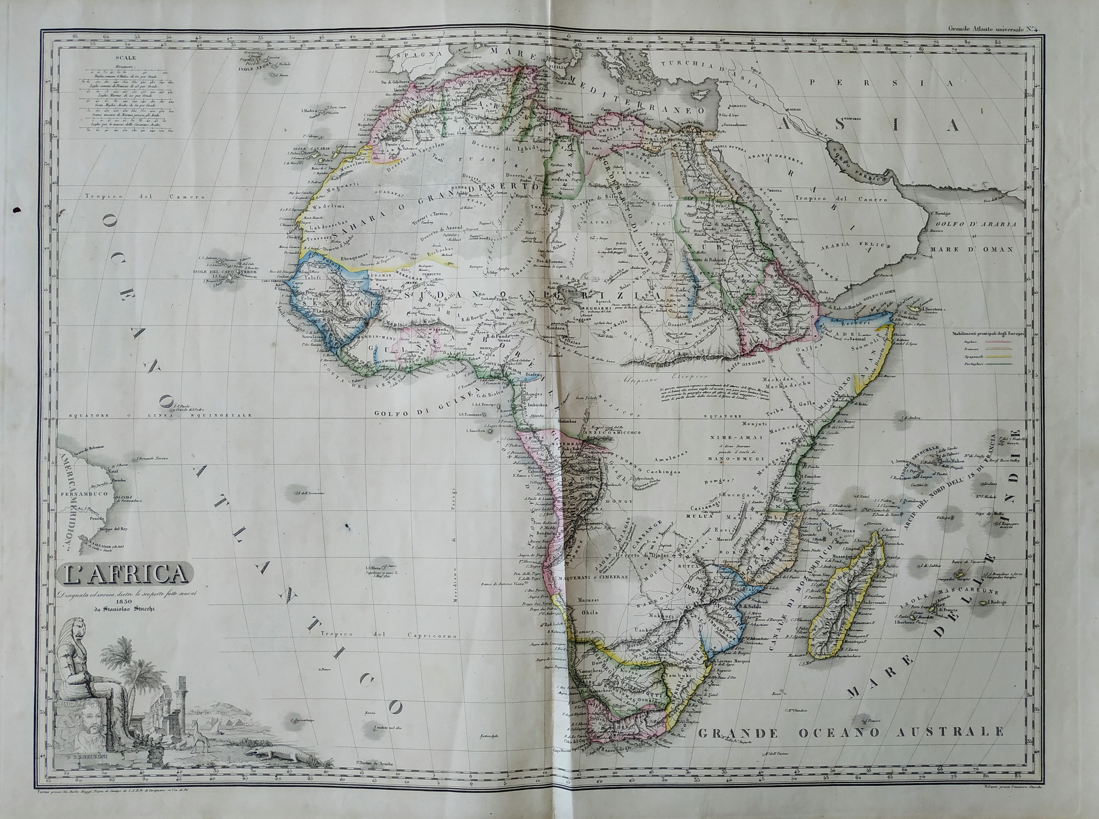
Map title
L'Africa
Author
Stucchi
Location shown in map
Africa
Edition date
1830
Edition place
Torino
Editor
Maggi
Atlas
Grande atlante universale
Price
Please ask: info@thetreasuremaps.com
State
[mint/excellent/VERY GOOD/good/fair/mediocre/poor]
Color
Old colors
Verso
Blank
Size
Plate: cm (70.9 x 53.1) inches (27.91 x 20.91) Paper: cm (81.8 x 59.9) inches (32.2 x 23.58)
Technique
Steel engraving
Note
--
Reference
--
Wiki
Here for more info
In stock
Available
Info
info@thetreasuremaps.com
Code
#0526
×
![L'Africa by Stucchi, Africa, 1830]()