British Isles
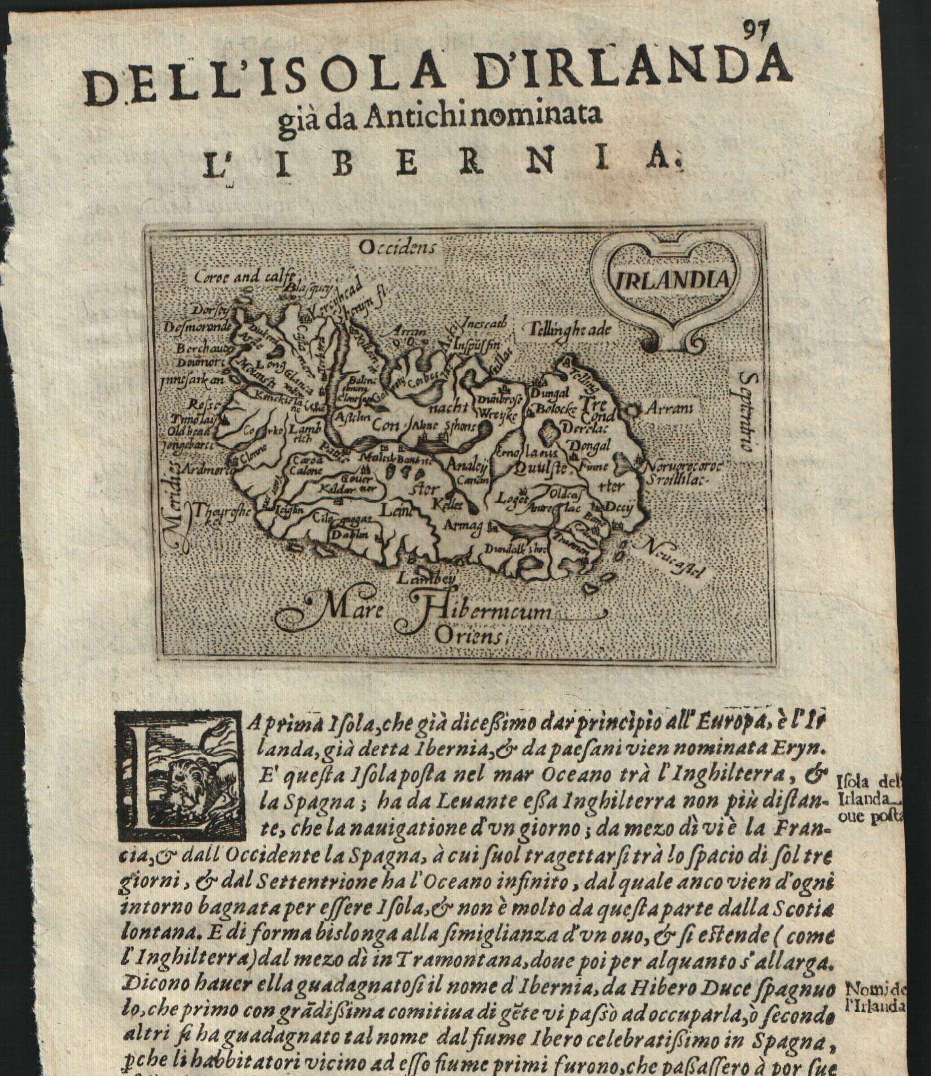
Map title
Irlandia
Author
Doglioni
Location shown in map
Ireland
Edition date
1623
Edition place
Venice
Editor
Giacomo Sarzina
Atlas
Anfiteatro di Europa
Price
Please ask: info@thetreasuremaps.com
State
[mint/EXCELLENT/very good/good/fair/mediocre/poor]
Color
Black/white
Verso
Italian text pag.98
Size
Plate: cm (11.4 x 8.9) inches (4.49 x 3.5) Paper: cm (15.2 x 22.9) inches (5.98 x 9.02)
Technique
Copper engraving
Note
The maps are copies of the Galle (c.1595) edition of Ortelius.
Reference
--
Wiki
Here for more info
In stock
Sold
Info
info@thetreasuremaps.com
Code
#0609
×
![Irlandia by Doglioni, Ireland, 1623]()
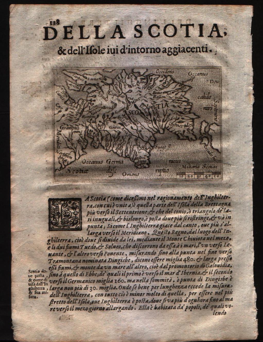
Map title
Scotia
Author
Doglioni
Location shown in map
Scotland
Edition date
1623
Edition place
Venice
Editor
Giacomo Sarzina
Atlas
Anfiteatro di Europa
Price
Please ask: info@thetreasuremaps.com
State
[MINT/excellent/very good/good/fair/mediocre/poor]
Color
Black/white
Verso
Italian text pag.127
Size
Plate: cm (11.4 x 8.9) inches (4.49 x 3.5) Paper: cm (15.2 x 22.9) inches (5.98 x 9.02)
Technique
Copper engraving
Note
The maps are copies of the Galle (c.1595) edition of Ortelius.
Reference
--
Wiki
Here for more info
In stock
Sold
Info
info@thetreasuremaps.com
Code
#0560
×
![Scotia by Doglioni, Scotland, 1623]()
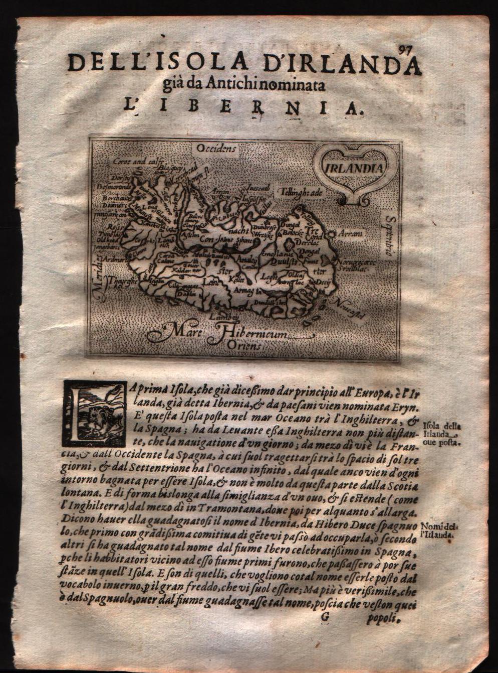
Map title
Irlandia
Author
Doglioni
Location shown in map
Ireland
Edition date
1623
Edition place
Venice
Editor
Giacomo Sarzina
Atlas
Anfiteatro di Europa
Price
Please ask: info@thetreasuremaps.com
State
[MINT/excellent/very good/good/fair/mediocre/poor]
Color
Black/white
Verso
Italian text pag.98
Size
Plate: cm (11.4 x 8.9) inches (4.49 x 3.5) Paper: cm (15.2 x 22.9) inches (5.98 x 9.02)
Technique
Copper engraving
Note
The maps are copies of the Galle (c.1595) edition of Ortelius.
Reference
--
Wiki
Here for more info
In stock
Sold
Info
info@thetreasuremaps.com
Code
#0559
×
![Irlandia by Doglioni, Ireland, 1623]()
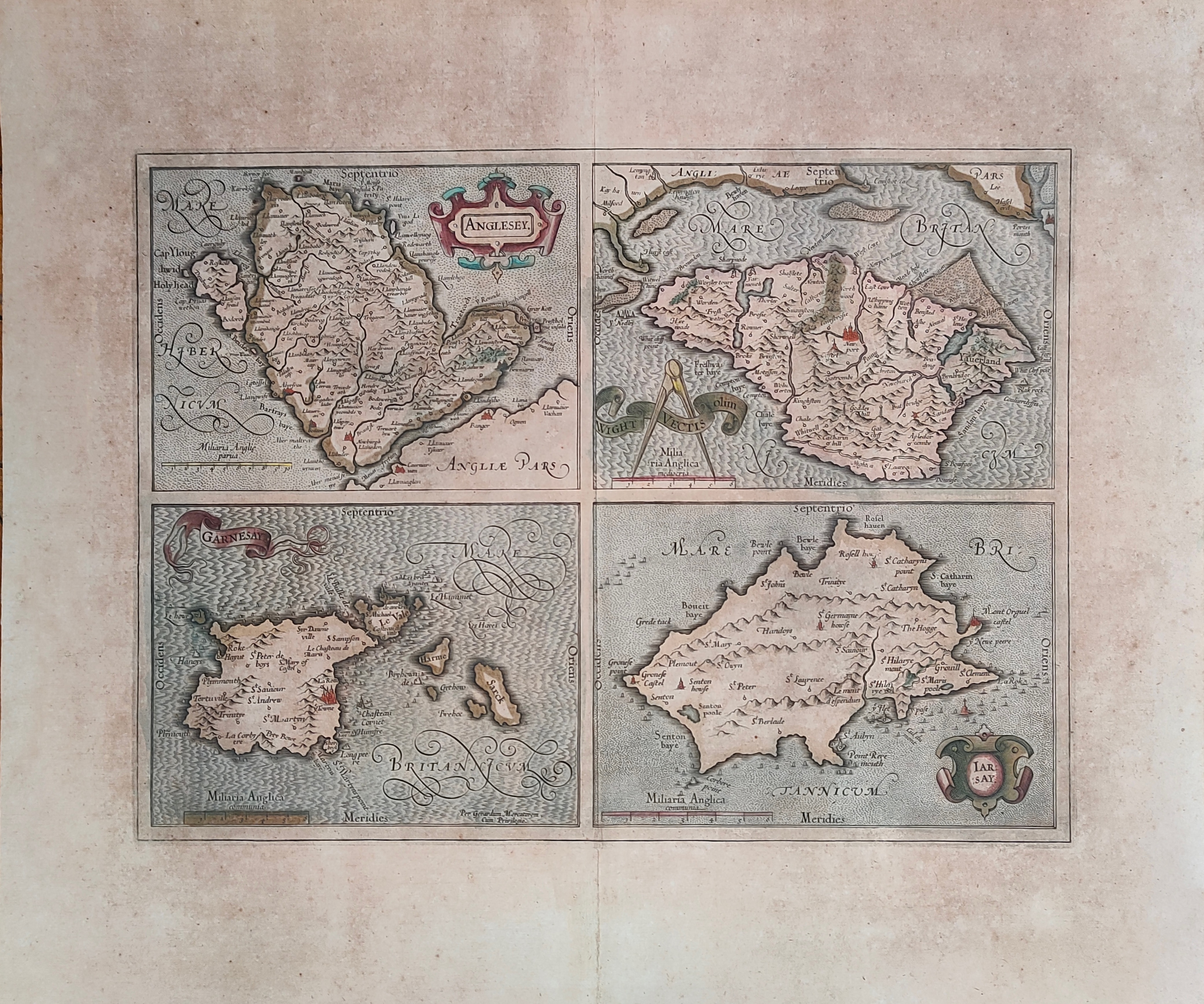
Map title
Anglesey, Garnesay, Wight olim Vectis, Iarsay
Author
Mercator
Location shown in map
Wight
Edition date
Circa 1628
Edition place
Amsterdam
Editor
Houndius
Atlas
Mercator-Hondius Atlas.
Price
250 Euro
State
[mint/EXCELLENT/very good/good/fair/mediocre/poor]
Color
Old colors
Verso
Latin text
Size
Plate: cm (42 x 32) inches (16.54 x 12.6) Paper: cm (55 x 47) inches (21.65 x 18.5)
Technique
Copper engraving
Note
Professionally repaired
Reference
Wiki
Here for more info
In stock
Available
Info
info@thetreasuremaps.com
Code
#1232
×
![Anglesey, Garnesay, Wight olim Vectis, Iarsay by Mercator, Wight, Circa 1628]()
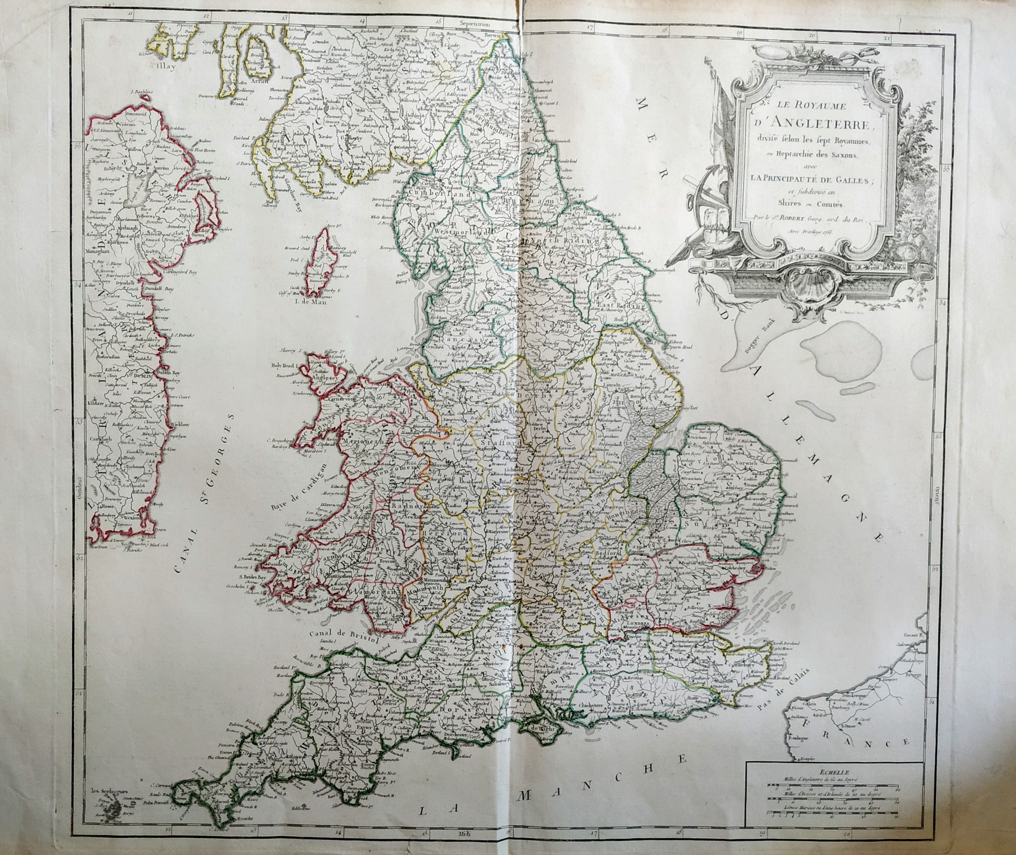
Map title
Scotiae pars septentrionalis
Author
Hondius
Location shown in map
Scotland
Edition date
1638
Edition place
Amsterdam
Editor
Atlas
Price
400 Euro
State
[mint/EXCELLENT/very good/good/fair/mediocre/poor]
Color
Old colors
Verso
Latin text
Size
Plate: cm (45 x 35) inches (17.72 x 13.78) Paper: cm (55 x 46) inches (21.65 x 18.11)
Technique
Copper engraving
Note
Reference
Wiki
Here for more info
In stock
Available
Info
info@thetreasuremaps.com
Code
#1073
×
![Scotiae pars septentrionalis by Hondius, Scotland, 1638]()
Map title
Carte generale des royaume d'Angleterre
Author
Sanson
Location shown in map
British Isles
Edition date
1640
Edition place
Paris
Editor
Melchior Tavenier
Atlas
Price
Please ask: info@thetreasuremaps.com
State
[mint/EXCELLENT/very good/good/fair/mediocre/poor]
Color
Old colors
Verso
Blank
Size
Plate: cm (52 x 39) inches (20.47 x 15.35) Paper: cm (57 x 44) inches (22.44 x 17.32)
Technique
Copper engraving
Note
No particular notes for this maps
Reference
Wiki
Here for more info
In stock
Available
Info
info@thetreasuremaps.com
Code
#0658
×
![Carte generale des royaume d'Angleterre by Sanson, British Isles, 1640]()
Map title
Carte generale des royaume d'Angleterre
Author
Sanson
Location shown in map
British Isles
Edition date
1658
Edition place
Paris
Editor
Melchior Tavenier
Atlas
Price
350 Euro
State
[mint/excellent/VERY GOOD/good/fair/mediocre/poor]
Color
Old colors
Verso
Blank
Size
Plate: cm (52 x 39) inches (20.47 x 15.35) Paper: cm (57 x 44) inches (22.44 x 17.32)
Technique
Copper engraving
Note
Reference
Wiki
Here for more info
In stock
Available
Info
info@thetreasuremaps.com
Code
#1173
×
![Carte generale des royaume d'Angleterre by Sanson, British Isles, 1658]()
Map title
De Fero de Scheland Orknay et Hebrides
Author
Mallet
Location shown in map
North of England
Edition date
1683
Edition place
Paris
Editor
--
Atlas
Description de l'univers - Chez Denis Thierry
Price
75 Euro
State
[mint/EXCELLENT/very good/good/fair/mediocre/poor] Only a small part of the map.
Color
Black/white
Verso
French text pag 24
Size
Plate: cm (10.2 x 15.2) inches (4.02 x 5.98) Paper: cm (12.7 x 20.3) inches (5 x 7.99)
Technique
Copper engraving
Note
No particular notes for this maps
Reference
--
Wiki
Here for more info
In stock
Available
Info
info@thetreasuremaps.com
Code
#0140
×
![De Fero de Scheland Orknay et Hebrides by Mallet, North of England, 1683]()

Map title
North-sea
Author
Keulen, Joannes
Location shown in map
British Isles
Edition date
1690
Edition place
Amsterdam
Editor
Atlas
Price
Please ask: info@thetreasuremaps.com
State
[mint/excellent/VERY GOOD/good/fair/mediocre/poor]
Color
Black/white
Verso
Blank
Size
Plate: cm (55 x 95) inches (21.65 x 37.4) Paper: cm (55 x 95) inches (21.65 x 37.4)
Technique
Copper engraving
Note
Professionally repaired
Reference
Wiki
Here for more info
In stock
Available
Info
info@thetreasuremaps.com
Code
#0740
×
![North-sea by Keulen, Joannes, British Isles, 1690]()
Map title
Scotia parte settentrionale
Author
Coronelli
Location shown in map
North Scotland
Edition date
1696
Edition place
Venice
Editor
--
Atlas
Isolario dell'atlante veneto
Price
400 Euro
State
[mint/EXCELLENT/very good/good/fair/mediocre/poor]
Color
Old colors
Verso
Italian tesx pag.22
Size
Plate: cm (62 x 46) inches (24.41 x 18.11) Paper: cm (64 x 47) inches (25.2 x 18.5)
Technique
Copper engraving
Note
Reference
--
Wiki
Here for more info
In stock
Available
Info
info@thetreasuremaps.com
Code
#1021
×
![Scotia parte settentrionale by Coronelli, North Scotland, 1696]()
Map title
Parte meridionale del regno d'Inghilterra
Author
Coronelli
Location shown in map
South England
Edition date
1696
Edition place
Venice
Editor
--
Atlas
Isolario dell'atlante veneto
Price
400 Euro
State
[mint/EXCELLENT/very good/good/fair/mediocre/poor]
Color
Old colors
Verso
Italian text pag.4
Size
Plate: cm (62 x 46) inches (24.41 x 18.11) Paper: cm (64 x 47) inches (25.2 x 18.5)
Technique
Copper engraving
Note
Reference
--
Wiki
Here for more info
In stock
Available
Info
info@thetreasuremaps.com
Code
#1020
×
![Parte meridionale del regno d'Inghilterra by Coronelli, South England, 1696]()
Map title
Nouvelle carte d'Angleterre d'Ecosse et d'Irlande
Author
Henri Chatelain
Location shown in map
Great Britain
Edition date
1719
Edition place
Amsterdam
Editor
Atlas
Atlas Historique
Price
350 Euro
State
[mint/EXCELLENT/very good/good/fair/mediocre/poor]
Color
Black/white
Verso
Blank
Size
Plate: cm (62 x 47) inches (24.41 x 18.5) Paper: cm (65 x 53) inches (25.59 x 20.87)
Technique
Copper engraving
Note
Reference
Wiki
Here for more info
In stock
Available
Info
info@thetreasuremaps.com
Code
#0813
×
![Nouvelle carte d'Angleterre d'Ecosse et d'Irlande by Henri Chatelain, Great Britain, 1719]()
Map title
Carte du gouvernment civil et miltaire avec l'etat des officiers du royaume d'Irlande
Author
Henri Chatelain
Location shown in map
Irland
Edition date
1719
Edition place
Amsterdam
Editor
Atlas
Atlas Historique
Price
200 Euro
State
[mint/EXCELLENT/very good/good/fair/mediocre/poor]
Color
Black/white
Verso
Blank
Size
Plate: cm (52 x 42) inches (20.47 x 16.54) Paper: cm (53 x 43) inches (20.87 x 16.93)
Technique
Copper engraving
Note
Reference
Wiki
Here for more info
In stock
Available
Info
info@thetreasuremaps.com
Code
#0825
×
![Carte du gouvernment civil et miltaire avec l'etat des officiers du royaume d'Irlande by Henri Chatelain, Irland, 1719]()
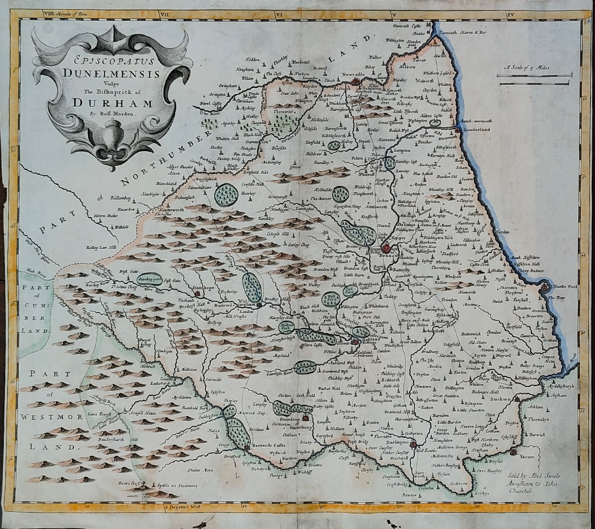
Map title
Episcopatus Dunelmenis
Author
Morden
Location shown in map
Dunelmenis
Edition date
1722
Edition place
London
Editor
Atlas
Price
100 Euro
State
[mint/excellent/VERY GOOD/good/fair/mediocre/poor]
Color
Old colors
Verso
Blank
Size
Plate: cm (42 x 36) inches (16.54 x 14.17) Paper: cm (42 x 36) inches (16.54 x 14.17)
Technique
Copper engraving
Note
Reference
Wiki
Here for more info
In stock
Available
Info
info@thetreasuremaps.com
Code
#1363
×
![Episcopatus Dunelmenis by Morden, Dunelmenis, 1722]()
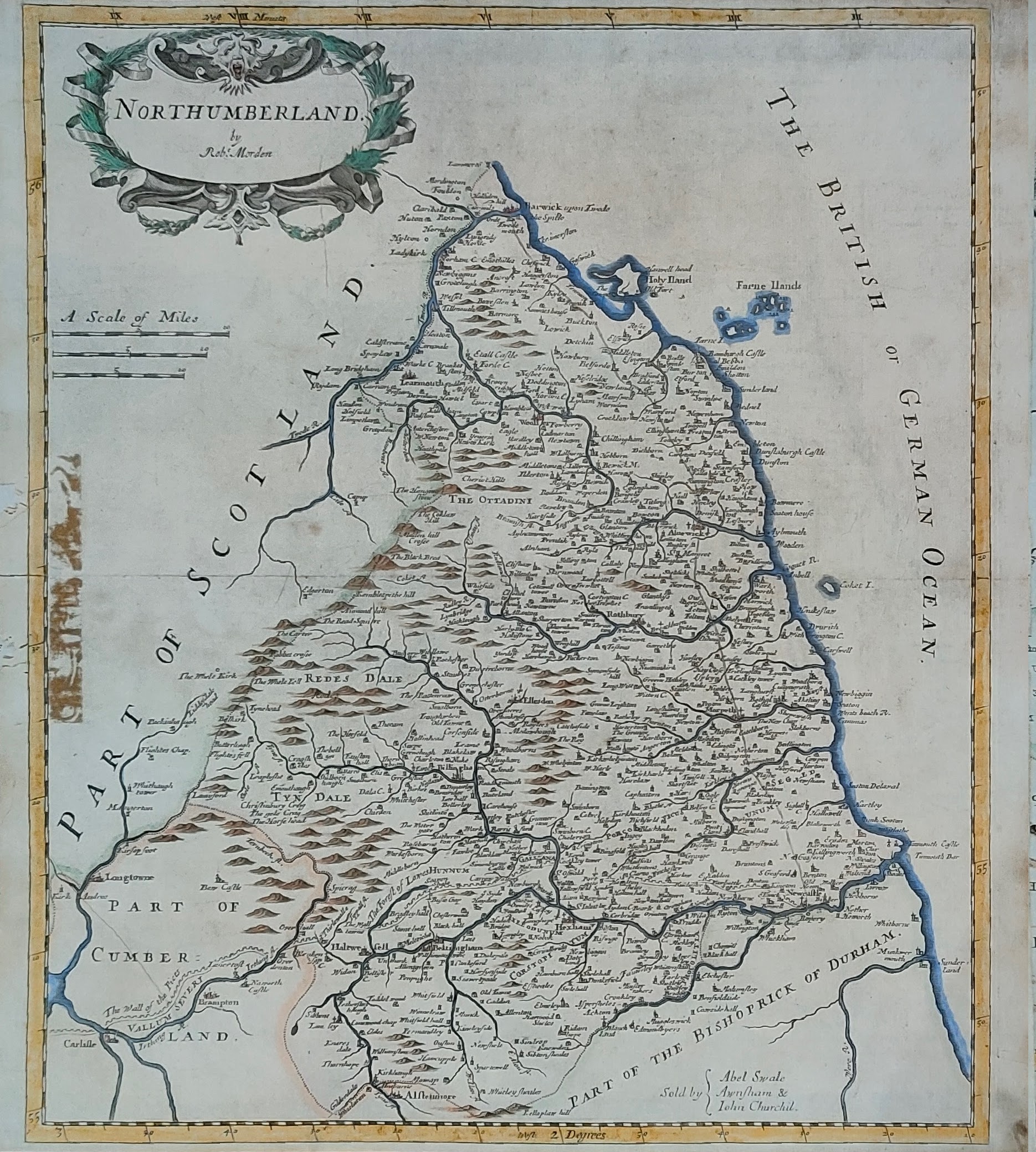
Map title
Northumberland
Author
Morden
Location shown in map
Northumberland
Edition date
1722
Edition place
London
Editor
Atlas
Price
100 Euro
State
[mint/excellent/VERY GOOD/good/fair/mediocre/poor]
Color
Old colors
Verso
Blank
Size
Plate: cm (36 x 42) inches (14.17 x 16.54) Paper: cm (36 x 42) inches (14.17 x 16.54)
Technique
Copper engraving
Note
Reference
Wiki
Here for more info
In stock
Available
Info
info@thetreasuremaps.com
Code
#1362
Northumberland
Author
Morden
Location shown in map
Northumberland
Edition date
1722
Edition place
London
Editor
Atlas
Price
100 Euro
State
[mint/excellent/VERY GOOD/good/fair/mediocre/poor]
Color
Old colors
Verso
Blank
Size
Plate: cm (36 x 42) inches (14.17 x 16.54) Paper: cm (36 x 42) inches (14.17 x 16.54)
Technique
Copper engraving
Note
Reference
Wiki
Here for more info
In stock
Available
Info
info@thetreasuremaps.com
Code
#1362
×
![Northumberland by Morden, Northumberland, 1722]()
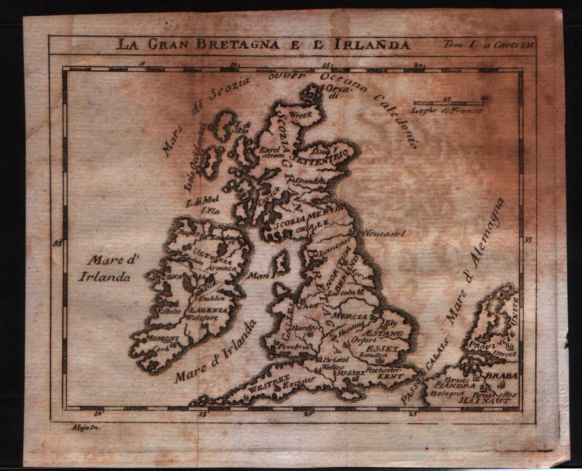
Map title
La Gran Bretagna e l'Irlanda
Author
Unknown
Location shown in map
British Isles
Edition date
1730
Edition place
???
Editor
--
Atlas
--
Price
125 Euro
State
[mint/excellent/VERY GOOD/good/fair/mediocre/poor]
Color
Black/white
Verso
Blank
Size
Plate: cm (15.2 x 12.7) inches (5.98 x 5) Paper: cm (18.4 x 15.9) inches (7.24 x 6.26)
Technique
Copper engraving
Note
No particular notes for this maps
Reference
--
Wiki
Here for more info
In stock
Available
Info
info@thetreasuremaps.com
Code
#0145
×
![La Gran Bretagna e l'Irlanda by Unknown, British Isles, 1730]()
Map title
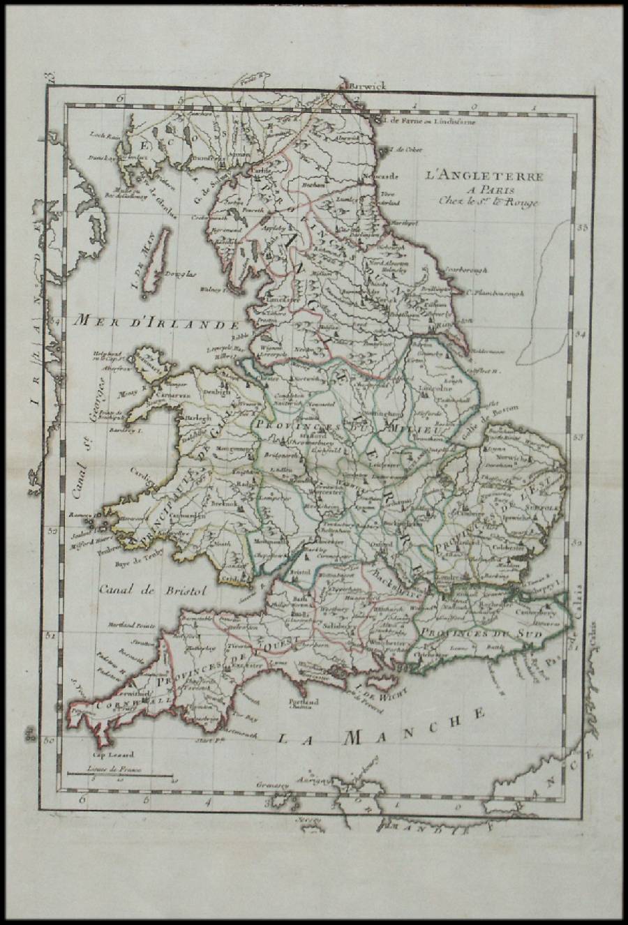
Le Royaume D'Ecosse
Author
Le Rouge
Location shown in map
Scotland
Edition date
1748
Edition place
Paris
Editor
--
Atlas
Atlas Nouveau Portatif l'usage des militaries et du voyageur
Price
125 Euro
State
[mint/EXCELLENT/very good/good/fair/mediocre/poor]
Color
Old outlined
Verso
Blank
Size
Plate: cm (20.3 x 27.3) inches (7.99 x 10.75) Paper: cm (20.3 x 27.3) inches (7.99 x 10.75)
Technique
Copper engraving
Note
No particular notes for this maps
Reference
--
Wiki
Here for more info
In stock
Available
Info
info@thetreasuremaps.com
Code
#0157
×
![Le Royaume D'Ecosse by Le Rouge, Scotland, 1748]()
Map title
L'Angleterre
Author
Le Rouge
Location shown in map
England
Edition date
1748
Edition place
Paris
Editor
--
Atlas
Atlas Nouveau Portatif l'usage des militaries et du voyageur
Price
125 Euro
State
[mint/EXCELLENT/very good/good/fair/mediocre/poor]
Color
Old outlined
Verso
Blank
Size
Plate: cm (20.3 x 27.3) inches (7.99 x 10.75) Paper: cm (20.3 x 27.3) inches (7.99 x 10.75)
Technique
Copper engraving
Note
No particular notes for this maps
Reference
--
Wiki
Here for more info
In stock
Available
Info
info@thetreasuremaps.com
Code
#0156
×
![L'Angleterre by Le Rouge, England, 1748]()
Map title
Le royaume d'Angleterre
Author
Robert de Vaugondy
Location shown in map
British Isles
Edition date
1753
Edition place
Paris
Editor
Delamarche
Atlas
Atlas Universel
Price
200 Euro
State
[mint/excellent/VERY GOOD/good/fair/mediocre/poor]
Color
Old color
Verso
Blank
Size
Plate: cm (66 x 51) inches (25.98 x 20.08) Paper: cm (53 x 49) inches (20.87 x 19.29)
Technique
Copper engraving
Note
No particular notes for this maps.
Reference
--
Wiki
Here for more info
In stock
Available
Info
info@thetreasuremaps.com
Code
#0759
×
![Le royaume d'Angleterre by Robert de Vaugondy, British Isles, 1753]()
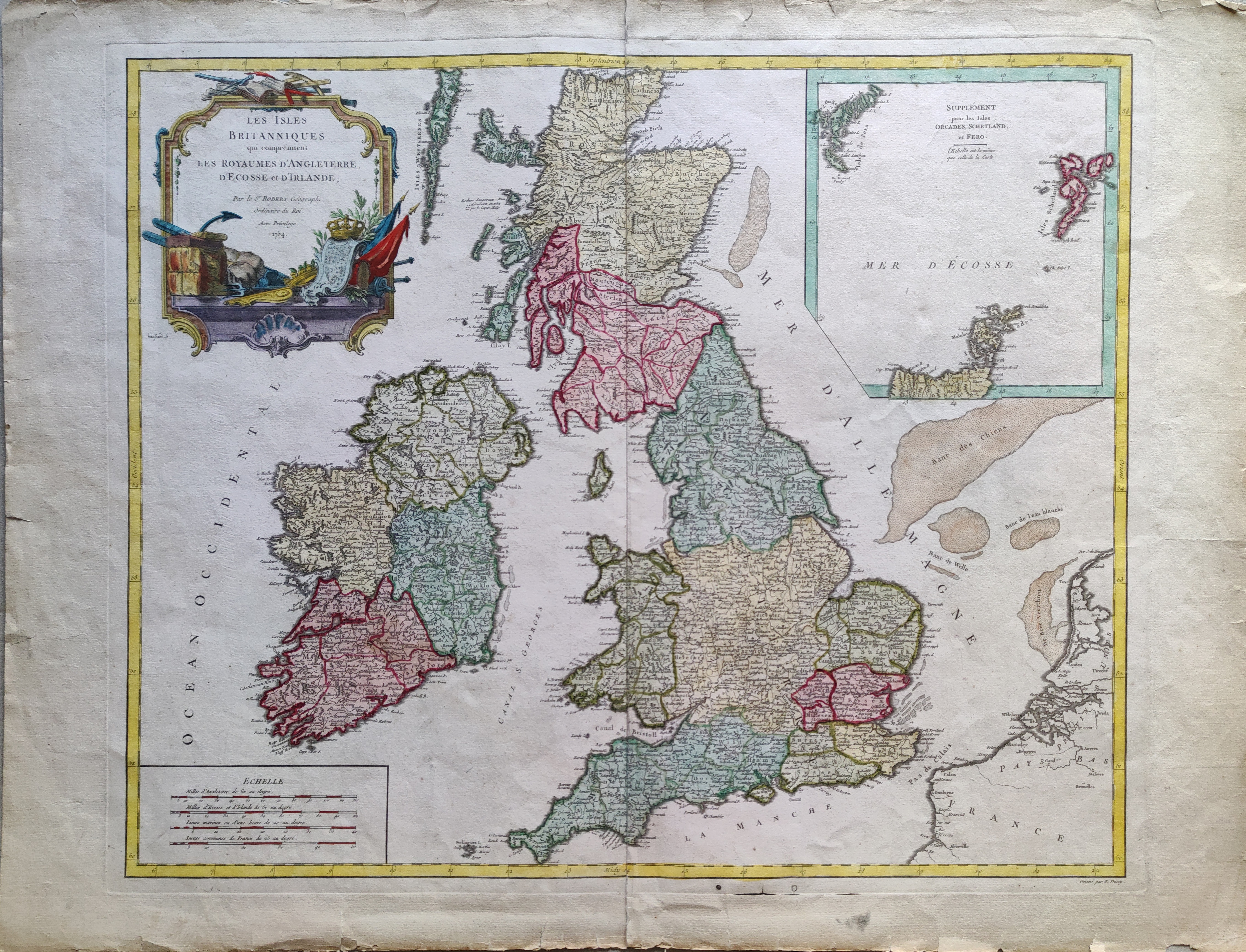
Map title
Les Isles Britanniques qui comprennent les Royaumes d'Angleterre, d'Ecosse et d'Irlande.
Author
Robert de Vaugondy
Location shown in map
British Isles
Edition date
1754
Edition place
Paris
Editor
Atlas
Atlas Universel
Price
200 Euro
State
[mint/EXCELLENT/very good/good/fair/mediocre/poor]
Color
Old colors
Verso
Blank
Size
Plate: cm (58 x 48) inches (22.83 x 18.9) Paper: cm (73 x 55) inches (28.74 x 21.65)
Technique
Copper engraving
Note
Reference
Wiki
Here for more info
In stock
Available
Info
info@thetreasuremaps.com
Code
#1072
×
![Les Isles Britanniques qui comprennent les Royaumes d'Angleterre, d'Ecosse et d'Irlande. by Robert de Vaugondy, British Isles, 1754]()