British Isles
Map title
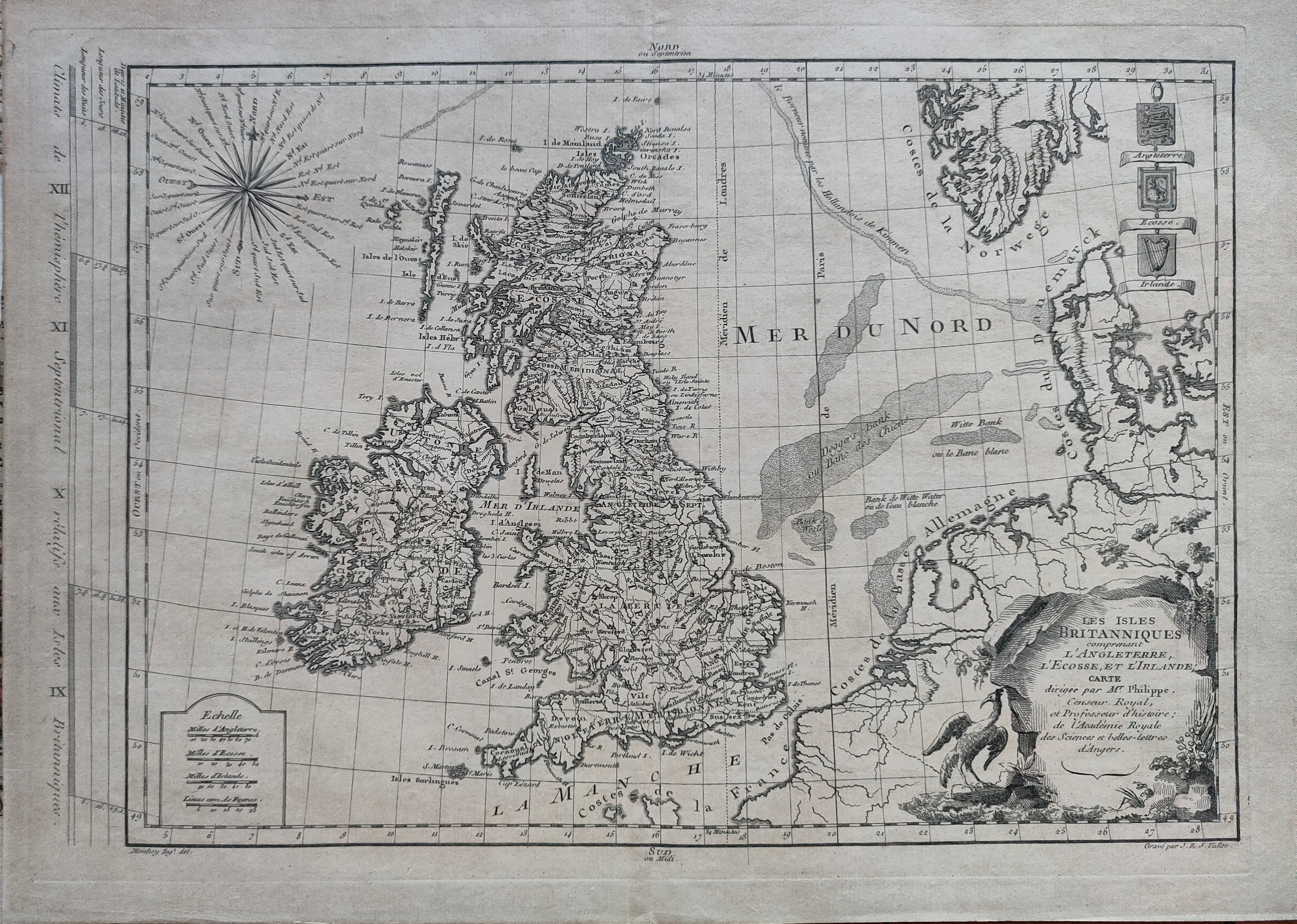
Les isles Britanniques
Author
Philippe
Location shown in map
British Isles
Edition date
1767
Edition place
Paris
Editor
Atlas
Price
125 Euro
State
[mint/EXCELLENT/very good/good/fair/mediocre/poor]
Color
Black/white
Verso
Blank
Size
Plate: cm (40 x 27) inches (15.75 x 10.63) Paper: cm (44 x 31) inches (17.32 x 12.2)
Technique
Copper engraving
Note
Reference
Wiki
Here for more info
In stock
Available
Info
info@thetreasuremaps.com
Code
#1215
×
![Les isles Britanniques by Philippe, British Isles, 1767]()
Map title
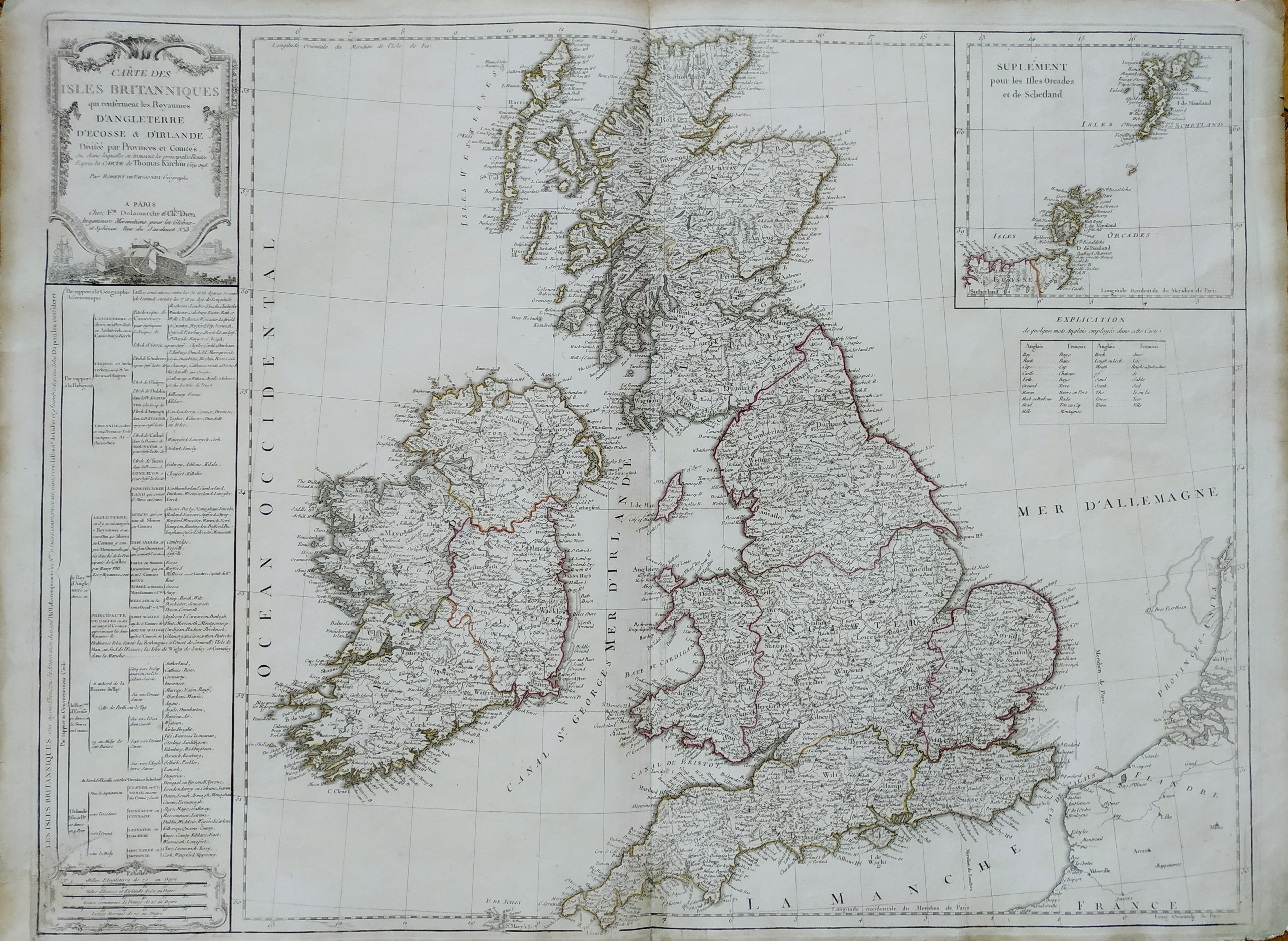
Cartes des isles Britanniques
Author
Robert de Vaugondy
Location shown in map
British Isles
Edition date
Circa 1780
Edition place
Paris
Editor
Delamarche
Atlas
Atlas d Etude pour l'instruction de la Jeunesse
Price
Please ask: info@thetreasuremaps.com
State
[mint/excellent/VERY GOOD/good/fair/mediocre/poor]
Color
Old color
Verso
Blank
Size
Plate: cm (71 x 53) inches (27.95 x 20.87) Paper: cm (77 x 57) inches (30.31 x 22.44)
Technique
Copper engraving
Note
Professionally rapaired
Reference
--
Wiki
Here for more info
In stock
Available
Info
info@thetreasuremaps.com
Code
#0744
×
![Cartes des isles Britanniques by Robert de Vaugondy, British Isles, Circa 1780]()
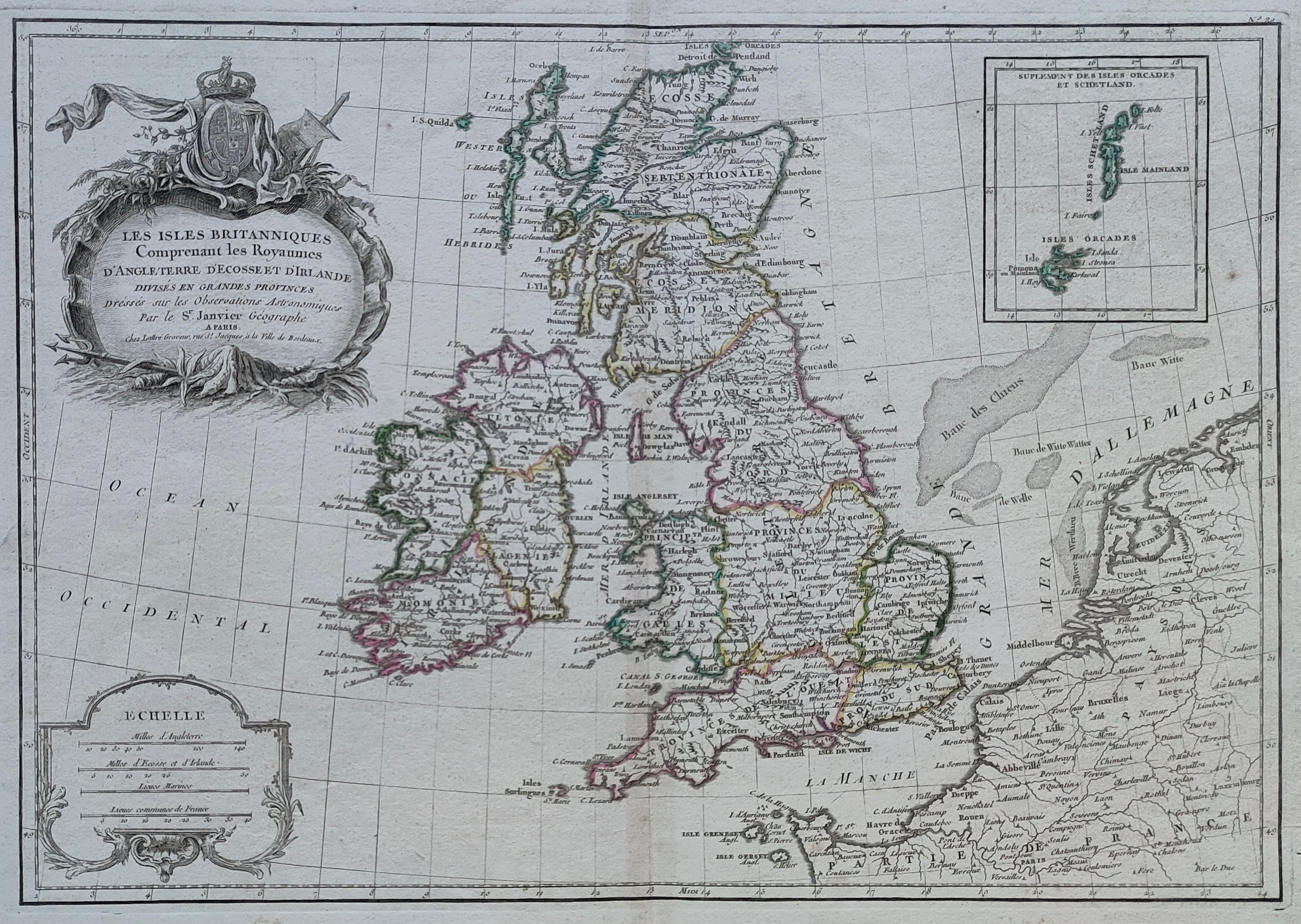
Map title
Les isles Britanniques
Author
Janvier
Location shown in map
British Isles
Edition date
Circa 1782
Edition place
Paris
Editor
Atlas
Price
150 Euro
State
[mint/EXCELLENT/very good/good/fair/mediocre/poor]
Color
Old colors
Verso
Blank
Size
Plate: cm (44 x 31) inches (17.32 x 12.2) Paper: cm (50 x 37) inches (19.69 x 14.57)
Technique
Copper engraving
Note
Reference
Wiki
Here for more info
In stock
Available
Info
info@thetreasuremaps.com
Code
#1216
×
![Les isles Britanniques by Janvier, British Isles, Circa 1782]()
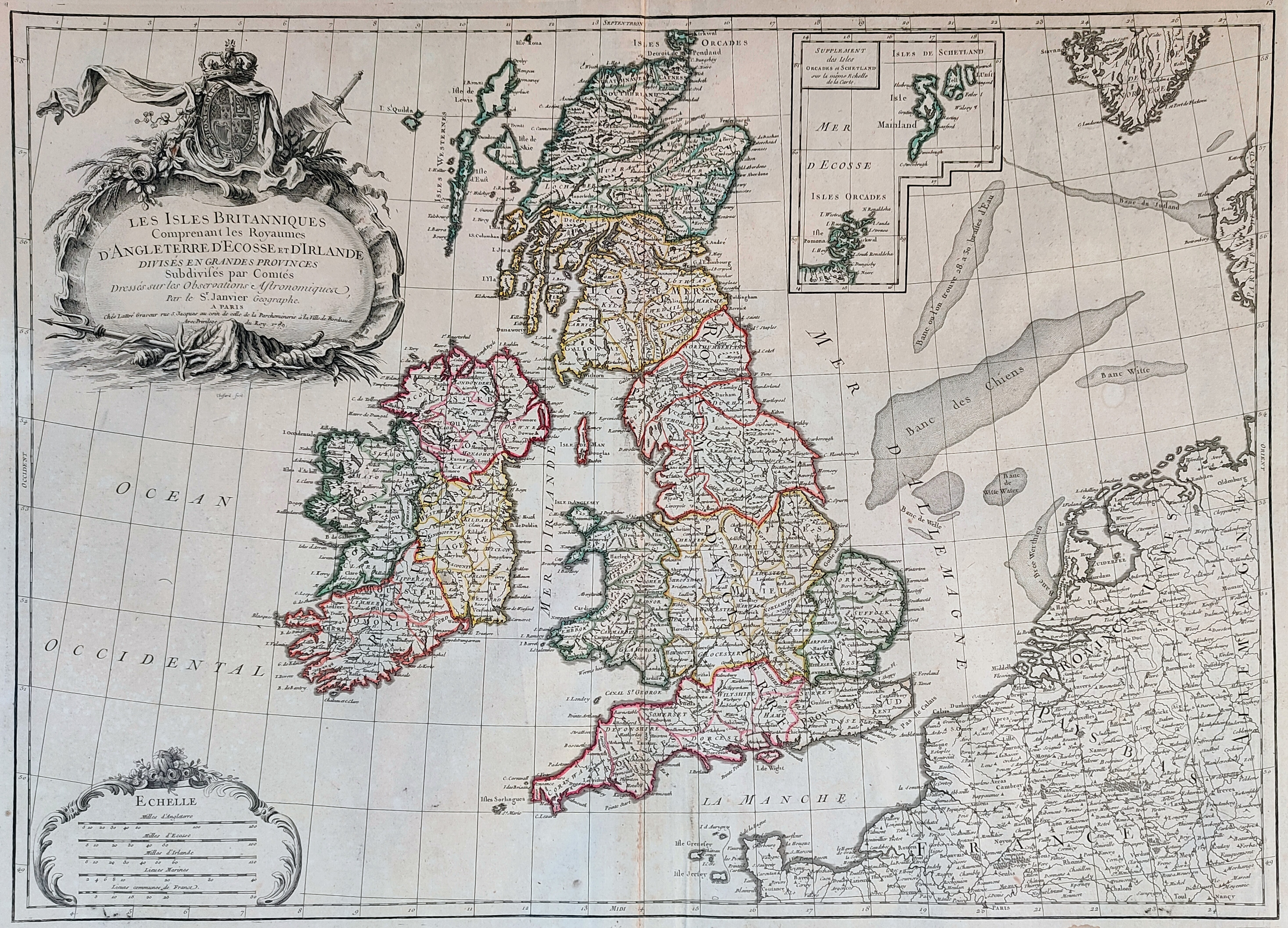
Map title
Les Iles Britanniques comprenant les Royaumes d'Angleterre ...
Author
Janvier
Location shown in map
England
Edition date
1784
Edition place
Venice
Editor
Atlas
Atlas Universel, dresse sur les meilleures cartes modernes
Price
250 Euro
State
[mint/EXCELLENT/very good/good/fair/mediocre/poor]
Color
Old colors
Verso
Blank
Size
Plate: cm (73 x 54) inches (28.74 x 21.26) Paper: cm (65 x 47) inches (25.59 x 18.5)
Technique
Copper engraving
Note
Reference
Wiki
Here for more info
In stock
Available
Info
info@thetreasuremaps.com
Code
#0920
×
![Les Iles Britanniques comprenant les Royaumes d'Angleterre ... by Janvier, England, 1784]()
Map title
Karte von England und Wallis
Author
Thomas Kitchin
Location shown in map
England
Edition date
1787
Edition place
Wien
Editor
Atlas
Price
350 Euro
State
[mint/EXCELLENT/very good/good/fair/mediocre/poor]
Color
Black/white
Verso
Blank
Size
Plate: cm (0 x 0) inches (0 x 0) Paper: cm (0 x 0) inches (0 x 0)
Technique
Copper engraving
Note
Reference
Wiki
Here for more info
In stock
Available
Info
info@thetreasuremaps.com
Code
#0826
×
![Karte von England und Wallis by Thomas Kitchin, England, 1787]()
Map title
Scozia
Author
Unknown
Location shown in map
Scotland
Edition date
1820
Edition place
Milan
Editor
--
Atlas
Atlante Nuovo di Batelli & Fanfani
Price
125 Euro
State
[mint/EXCELLENT/very good/good/fair/mediocre/poor]
Color
Old outlined
Verso
Blank
Size
Plate: cm (21.6 x 17.8) inches (8.5 x 7.01) Paper: cm (21.6 x 17.8) inches (8.5 x 7.01)
Technique
--
Note
No particular notes for this maps
Reference
--
Wiki
Here for more info
In stock
Sold
Info
info@thetreasuremaps.com
Code
#0491
×
![Scozia by Unknown, Scotland, 1820]()
Map title
Iles Britannique
Author
Monin
Location shown in map
British Isles
Edition date
1840
Edition place
Paris
Editor
Atlas
Atlas Classique de la Geographie
Price
75 Euro
State
[mint/EXCELLENT/very good/good/fair/mediocre/poor]
Color
Old colors
Verso
Blank
Size
Plate: cm (28 x 37) inches (11.02 x 14.57) Paper: cm (33 x 45) inches (12.99 x 17.72)
Technique
Copper engraving
Note
Reference
Wiki
Here for more info
In stock
Available
Info
info@thetreasuremaps.com
Code
#1010
×
![Iles Britannique by Monin, British Isles, 1840]()
Map title
London
Author
Benjamin Rees Davies
Location shown in map
London
Edition date
1843
Edition place
London
Editor
S.D.U.K.
Atlas
Price
250 Euro
State
[mint/EXCELLENT/very good/good/fair/mediocre/poor]
Color
Old color
Verso
Blank
Size
Plate: cm (65 x 39) inches (25.59 x 15.35) Paper: cm (67 x 40) inches (26.38 x 15.75)
Technique
Steel engraving
Note
No particular notes for this maps.
Reference
Wiki
Here for more info
In stock
Sold
Info
info@thetreasuremaps.com
Code
#0743
London
Author
Benjamin Rees Davies
Location shown in map
London
Edition date
1843
Edition place
London
Editor
S.D.U.K.
Atlas
Price
250 Euro
State
[mint/EXCELLENT/very good/good/fair/mediocre/poor]
Color
Old color
Verso
Blank
Size
Plate: cm (65 x 39) inches (25.59 x 15.35) Paper: cm (67 x 40) inches (26.38 x 15.75)
Technique
Steel engraving
Note
No particular notes for this maps.
Reference
Wiki
Here for more info
In stock
Sold
Info
info@thetreasuremaps.com
Code
#0743
×
![London by Benjamin Rees Davies, London, 1843]()

Map title
England
Author
Unknown
Location shown in map
--
Edition date
Unknown
Edition place
???
Editor
--
Atlas
--
Price
Please ask: info@thetreasuremaps.com
State
[mint/excellent/very good/good/fair/mediocre/POOR]
Color
Old outlined
Verso
Blank
Size
Plate: cm (119.4 x 91.4) inches (47.01 x 35.98) Paper: cm (119.4 x 91.4) inches (47.01 x 35.98)
Technique
Copper engraving
Note
Very large wall map
Reference
--
Wiki
Here for more info
In stock
Sold
Info
info@thetreasuremaps.com
Code
#0142
×
![England by Unknown, --, Unknown]()