China
Pages: 1 2
Map title
Cambaleschia
Author
Foresti
Location shown in map
City of Beijing
Edition date
1508
Edition place
Venice
Editor
Georgii de Rusconibus
Atlas
Supplementum supplementi cronicarum
Price
Please ask: info@thetreasuremaps.com
State
[MINT/excellent/very good/good/fair/mediocre/poor]
Color
Black/white
Verso
Italian text
Size
Plate: cm (8.9 x 6.4) inches (3.5 x 2.52) Paper: cm (21.6 x 30.5) inches (8.5 x 12.01)
Technique
Woodcut
Note
No particular notes for this maps.
Reference
--
Wiki
Here for more info
In stock
Available
Info
info@thetreasuremaps.com
Code
#0011
×
![Cambaleschia by Foresti, City of Beijing, 1508]()
Map title
Chinae
Author
Ortelius
Location shown in map
China
Edition date
1595
Edition place
Antwerp
Editor
--
Atlas
Theatrum Orbis Terrarum
Price
3000 Euro
State
[mint/EXCELLENT/very good/good/fair/mediocre/poor]
Color
Old color
Verso
Latin text pag.106
Size
Plate: cm (47 x 37) inches (18.5 x 14.57) Paper: cm (54 x 43) inches (21.26 x 16.93)
Technique
Copper engraving
Note
Reference
Van Den Broecke 215
Wiki
Here for more info
In stock
Sold
Info
info@thetreasuremaps.com
Code
#1210
×
![Chinae by Ortelius, China, 1595]()
Map title
Situs provinciarum imperii sinici
Author
Martini
Location shown in map
China
Edition date
1654
Edition place
Cologne
Editor
Atlas
De bello Tartarico historia
Price
400 Euro
State
[mint/EXCELLENT/very good/good/fair/mediocre/poor]
Color
Black/white
Verso
Blank
Size
Plate: cm (16 x 13) inches (6.3 x 5.12) Paper: cm (19 x 18) inches (7.48 x 7.09)
Technique
Copper engraving
Note
Reference
--
Wiki
Here for more info
In stock
Available
Info
info@thetreasuremaps.com
Code
#1202
×
![Situs provinciarum imperii sinici by Martini, China, 1654]()
Map title
Imperii Sinarum Nova Descriptio
Author
Blaeu
Location shown in map
China
Edition date
1655
Edition place
Amsterdam
Editor
Atlas
Atlas Sinensis
Price
1100 Euro
State
[mint/excellent/very good/good/fair/MEDIOCRE/poor]
Color
Old colors
Verso
Blank
Size
Plate: cm (60 x 46) inches (23.62 x 18.11) Paper: cm (60 x 46) inches (23.62 x 18.11)
Technique
Copper engraving
Note
No particular notes for this maps.
Reference
--
Wiki
Here for more info
In stock
Available
Info
info@thetreasuremaps.com
Code
#0938
×
![Imperii Sinarum Nova Descriptio by Blaeu, China, 1655]()
Map title
Il regno della China
Author
De Rossi
Location shown in map
China
Edition date
1682
Edition place
Rome
Editor
De Rossi
Atlas
Mercurio Geografico
Price
1600 Euro
State
[mint/EXCELLENT/very good/good/fair/mediocre/poor]
Color
Old colors
Verso
Blank
Size
Plate: cm (55 x 39) inches (21.65 x 15.35) Paper: cm (60 x 48) inches (23.62 x 18.9)
Technique
Copper engraving
Note
Reference
Wiki
Here for more info
In stock
Available
Info
info@thetreasuremaps.com
Code
#0984
×
![Il regno della China by De Rossi, China, 1682]()
Map title
Parte occidentale della China - Parte occidentale della Cina
Author
Coronelli
Location shown in map
China
Edition date
Circa 1692
Edition place
Venice
Editor
Atlas
Corso geografico universale
Price
4500 Euro
State
[mint/EXCELLENT/very good/good/fair/mediocre/poor]
Color
Black/white
Verso
Blank
Size
Plate: cm (94 x 60) inches (37.01 x 23.62) Paper: cm (97 x 66) inches (38.19 x 25.98)
Technique
Copper engraving
Note
Two sheets
Reference
--
Wiki
Here for more info
In stock
Available
Info
info@thetreasuremaps.com
Code
#1338
×
![Parte occidentale della China - Parte occidentale della Cina by Coronelli, China, Circa 1692]()
Map title
La Chine
Author
Peeters
Location shown in map
China
Edition date
1692
Edition place
Antwerp
Editor
Atlas
Imperii Sinarum nova descriptio
Price
150 Euro
State
[mint/EXCELLENT/very good/good/fair/mediocre/poor]
Color
Black/white
Verso
Blank
Size
Plate: cm (16 x 13) inches (6.3 x 5.12) Paper: cm (19 x 18) inches (7.48 x 7.09)
Technique
Copper engraving
Note
Reference
--
Wiki
Here for more info
In stock
Available
Info
info@thetreasuremaps.com
Code
#1185
×
![La Chine by Peeters, China, 1692]()
Map title
Parte orientale della China
Author
Coronelli
Location shown in map
China
Edition date
Circa 1692
Edition place
Venice
Editor
Atlas
Corso geografico universale
Price
2000 Euro
State
[mint/EXCELLENT/very good/good/fair/mediocre/poor]
Color
Black/white
Verso
Blank
Size
Plate: cm (45 x 60) inches (17.72 x 23.62) Paper: cm (71 x 50) inches (27.95 x 19.69)
Technique
Copper engraving
Note
Reference
--
Wiki
Here for more info
In stock
Available
Info
info@thetreasuremaps.com
Code
#1275
×
![Parte orientale della China by Coronelli, China, Circa 1692]()
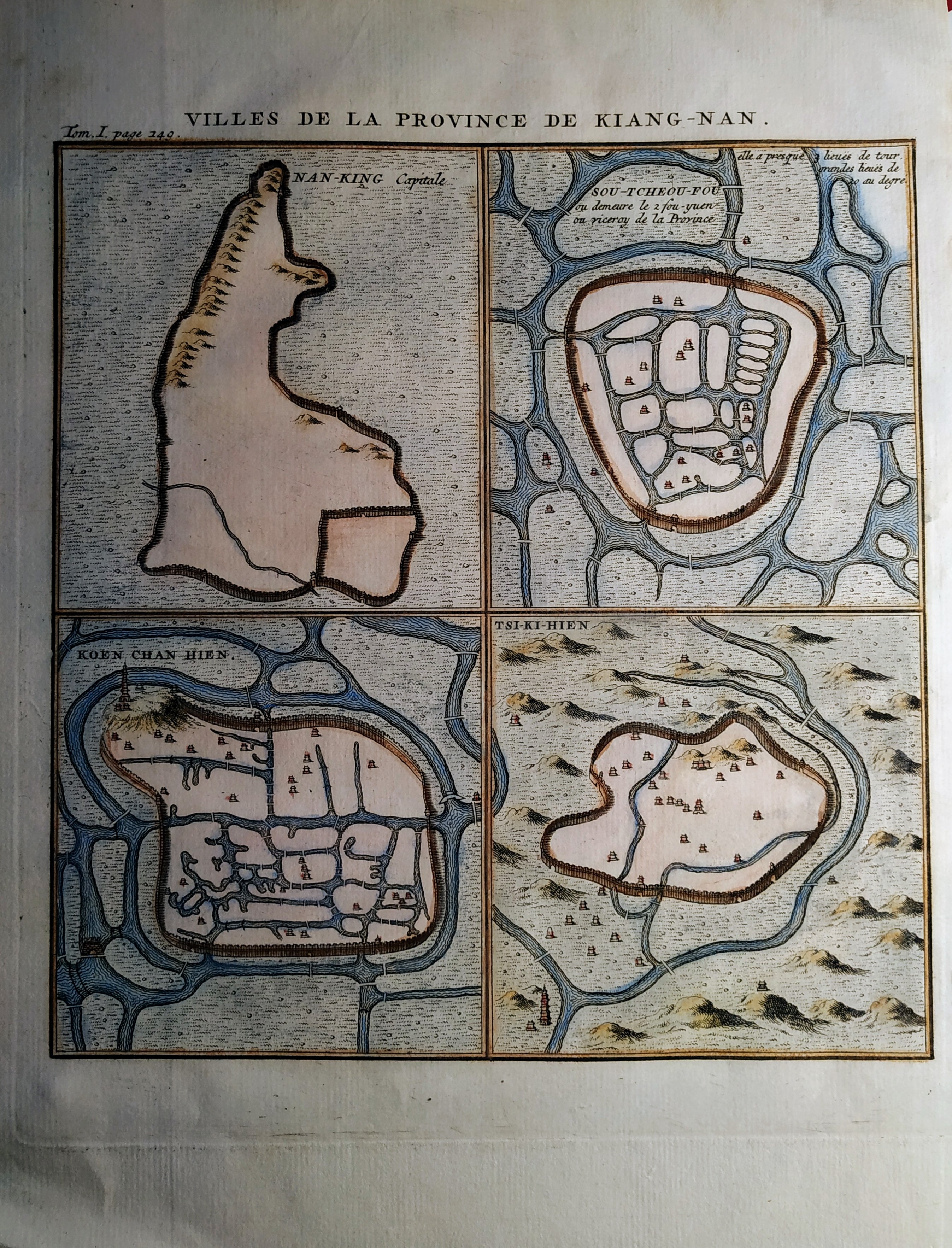
Map title
Villes de la Province de Kiang-Nan
Author
Henri Scheurleer
Location shown in map
Jangsung
Edition date
1736
Edition place
The Haugue
Editor
Atlas
Description de la Chine
Price
50 Euro
State
[mint/EXCELLENT/very good/good/fair/mediocre/poor]
Color
Old colors
Verso
Blank
Size
Plate: cm (17 x 19) inches (6.69 x 7.48) Paper: cm (20 x 26) inches (7.87 x 10.24)
Technique
Copper engraving
Note
No particular notes for this maps
Reference
Wiki
Here for more info
In stock
Available
Info
info@thetreasuremaps.com
Code
#0704
×
![Villes de la Province de Kiang-Nan by Henri Scheurleer, Jangsung, 1736]()
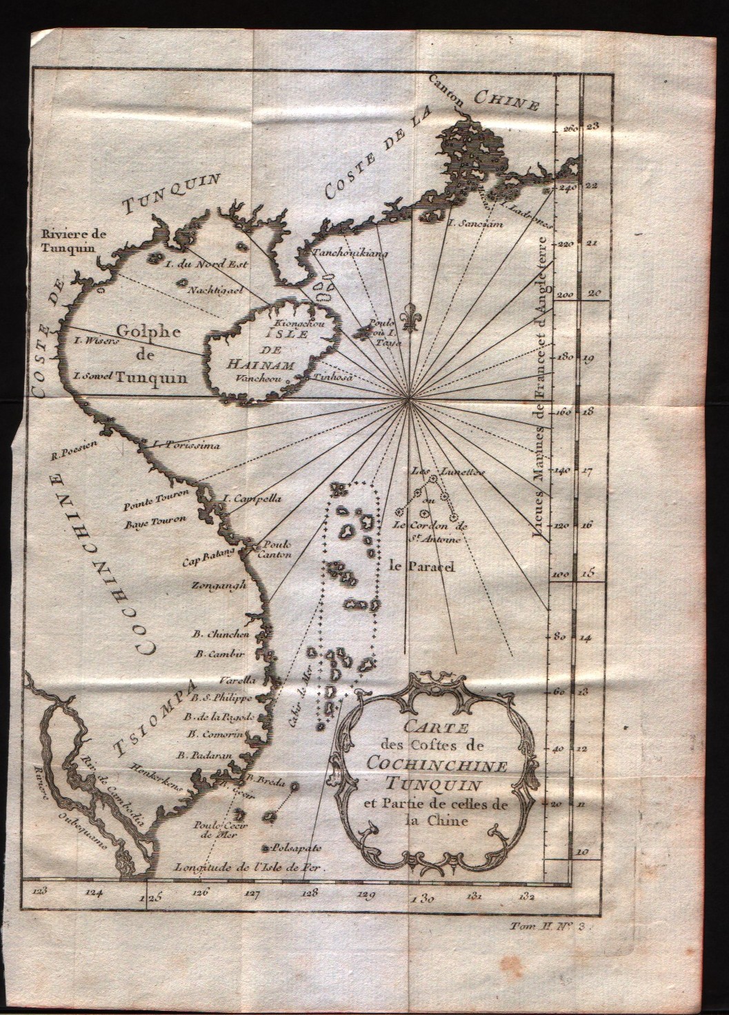
Map title
Carte des costes de Cochin Chine, Tunquin, et partie de celles de la Chine
Author
Bellin
Location shown in map
--
Edition date
1757
Edition place
Paris
Editor
--
Atlas
Historie General des Voyages -- Prevost
Price
125 Euro
State
[mint/EXCELLENT/very good/good/fair/mediocre/poor]
Color
Black/white
Verso
Blank
Size
Plate: cm (15.2 x 20.3) inches (5.98 x 7.99) Paper: cm (17.8 x 24.1) inches (7.01 x 9.49)
Technique
Copper engraving
Note
No particular notes for this maps
Reference
--
Wiki
Here for more info
In stock
Available
Info
info@thetreasuremaps.com
Code
#0224
×
![Carte des costes de Cochin Chine, Tunquin, et partie de celles de la Chine by Bellin, --, 1757]()

Map title
L'isle Formose
Author
Bellin
Location shown in map
Taiwan
Edition date
1757
Edition place
Paris
Editor
--
Atlas
Historie General des Voyages -- Prevost
Price
Please ask: info@thetreasuremaps.com
State
[mint/EXCELLENT/very good/good/fair/mediocre/poor]
Color
Black/white
Verso
Blank
Size
Plate: cm (25.4 x 22.9) inches (10 x 9.02) Paper: cm (30.5 x 24.1) inches (12.01 x 9.49)
Technique
Copper engraving
Note
No particular notes for this maps
Reference
--
Wiki
Here for more info
In stock
Sold
Info
info@thetreasuremaps.com
Code
#0449
×
![L'isle Formose by Bellin, Taiwan, 1757]()
Map title
Carte de la baye de Chin-Chew ou Chang-Chew
Author
Bellin
Location shown in map
--
Edition date
1757
Edition place
Paris
Editor
--
Atlas
Historie General des Voyages -- Prevost
Price
Please ask: info@thetreasuremaps.com
State
[mint/EXCELLENT/very good/good/fair/mediocre/poor]
Color
Black/white
Verso
Blank
Size
Plate: cm (29.2 x 21.6) inches (11.5 x 8.5) Paper: cm (30.5 x 22.9) inches (12.01 x 9.02)
Technique
Copper engraving
Note
No particular notes for this maps
Reference
--
Wiki
Here for more info
In stock
Sold
Info
info@thetreasuremaps.com
Code
#0448
×
![Carte de la baye de Chin-Chew ou Chang-Chew by Bellin, --, 1757]()
Map title
Carte de la Baye de Hocsieu et des Entrées de la Riviere de Chang
Author
Bellin
Location shown in map
Estuary of the Chiang River now Fu-chou in the province of Fukien.
Edition date
1757
Edition place
Paris
Editor
--
Atlas
Historie General des Voyages -- Prevost
Price
Please ask: info@thetreasuremaps.com
State
[mint/EXCELLENT/very good/good/fair/mediocre/poor]
Color
Black/white
Verso
Blank
Size
Plate: cm (27.9 x 20.3) inches (10.98 x 7.99) Paper: cm (36.8 x 27.9) inches (14.49 x 10.98)
Technique
Copper engraving
Note
No particular notes for this maps
Reference
--
Wiki
Here for more info
In stock
Sold
Info
info@thetreasuremaps.com
Code
#0431
×
![Carte de la Baye de Hocsieu et des Entrées de la Riviere de Chang by Bellin, Estuary of the Chiang River now Fu-chou in the province of Fukien., 1757]()
Map title
L'Empire De La Chine
Author
Bellin
Location shown in map
--
Edition date
1757
Edition place
Paris
Editor
--
Atlas
Historie General des Voyages -- Prevost
Price
Please ask: info@thetreasuremaps.com
State
[mint/excellent/VERY GOOD/good/fair/mediocre/poor]
Color
Black/white
Verso
Blank
Size
Plate: cm (40.6 x 27.9) inches (15.98 x 10.98) Paper: cm (41.9 x 32.4) inches (16.5 x 12.76)
Technique
Copper engraving
Note
No particular notes for this maps
Reference
--
Wiki
Here for more info
In stock
Sold
Info
info@thetreasuremaps.com
Code
#0428
×
![L'Empire De La Chine by Bellin, --, 1757]()
Map title
Plan de la Ville de Peking
Author
Bellin
Location shown in map
Pekin
Edition date
1757
Edition place
Paris
Editor
--
Atlas
Historie General des Voyages -- Prevost
Price
Please ask: info@thetreasuremaps.com
State
[mint/EXCELLENT/very good/good/fair/mediocre/poor]
Color
Black/white
Verso
Blank
Size
Plate: cm (15.2 x 21.6) inches (5.98 x 8.5) Paper: cm (16.5 x 22.9) inches (6.5 x 9.02)
Technique
Copper engraving
Note
No particular notes for this maps
Reference
--
Wiki
Here for more info
In stock
Sold
Info
info@thetreasuremaps.com
Code
#0396
×
![Plan de la Ville de Peking by Bellin, Pekin, 1757]()
Map title
Carte du cours de la riviere de Tunquin depuis Cacho jusqu'a a la mer, levee par un navigateur Anglois
Author
Bellin
Location shown in map
The Tonkin River and the Tonkin Gulf.
Edition date
1757
Edition place
Paris
Editor
--
Atlas
Historie General des Voyages -- Prevost
Price
Please ask: info@thetreasuremaps.com
State
[mint/EXCELLENT/very good/good/fair/mediocre/poor]
Color
Black/white
Verso
Blank
Size
Plate: cm (14 x 20.3) inches (5.51 x 7.99) Paper: cm (20.3 x 27.9) inches (7.99 x 10.98)
Technique
Copper engraving
Note
No particular notes for this maps
Reference
--
Wiki
Here for more info
In stock
Sold
Info
info@thetreasuremaps.com
Code
#0256
×
![Carte du cours de la riviere de Tunquin depuis Cacho jusqu'a a la mer, levee par un navigateur Anglois by Bellin, The Tonkin River and the Tonkin Gulf., 1757]()
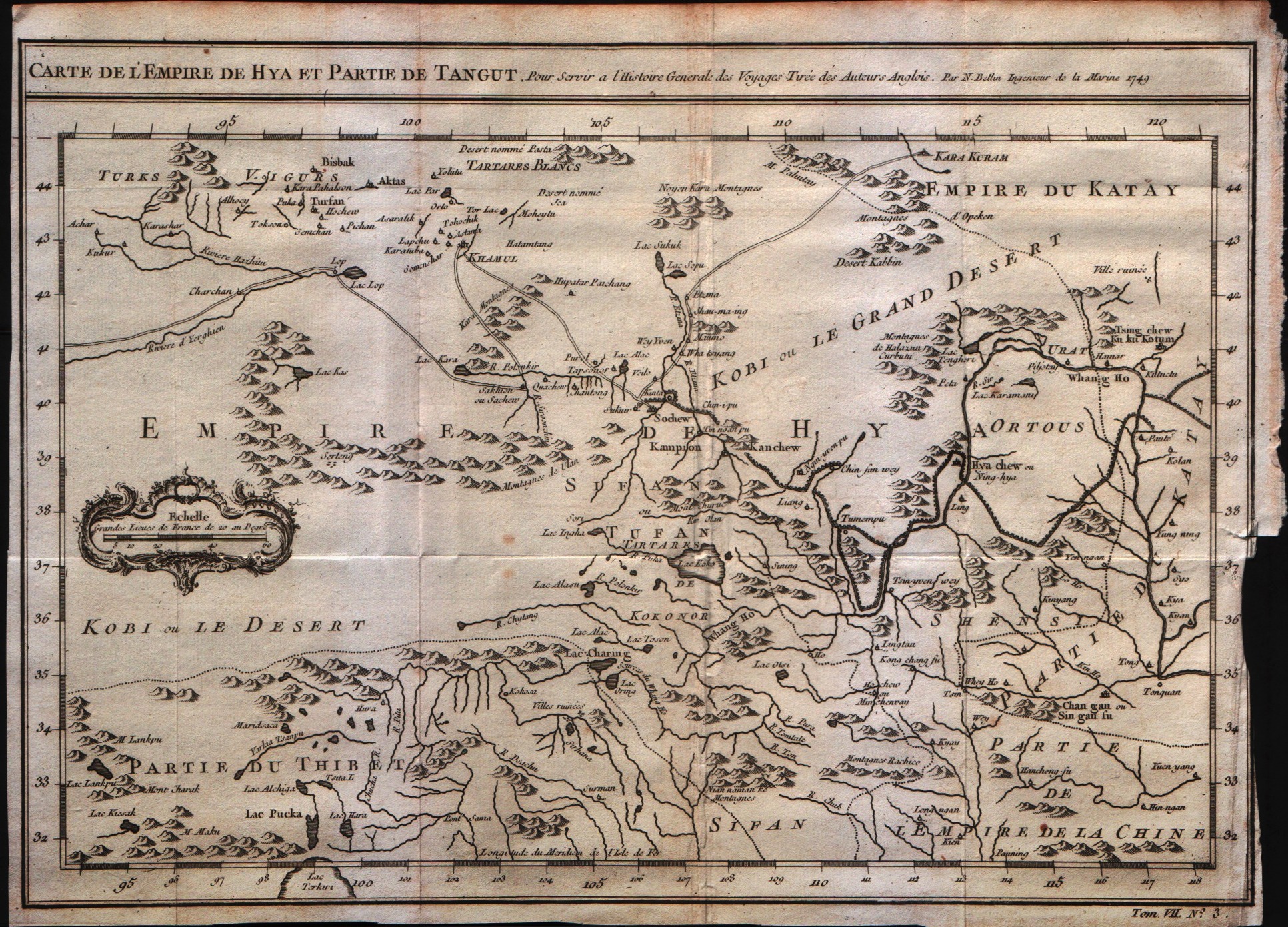
Map title
Carte de l'empire de Hya et Partie de Tangut
Author
Bellin
Location shown in map
--
Edition date
1757
Edition place
Paris
Editor
--
Atlas
Historie General des Voyages -- Prevost
Price
Please ask: info@thetreasuremaps.com
State
[mint/EXCELLENT/very good/good/fair/mediocre/poor]
Color
Black/white
Verso
Blank
Size
Plate: cm (30.5 x 21.6) inches (12.01 x 8.5) Paper: cm (31.8 x 24.1) inches (12.52 x 9.49)
Technique
Copper engraving
Note
No particular notes for this maps
Reference
--
Wiki
Here for more info
In stock
Available
Info
info@thetreasuremaps.com
Code
#0226
×
![Carte de l'empire de Hya et Partie de Tangut by Bellin, --, 1757]()
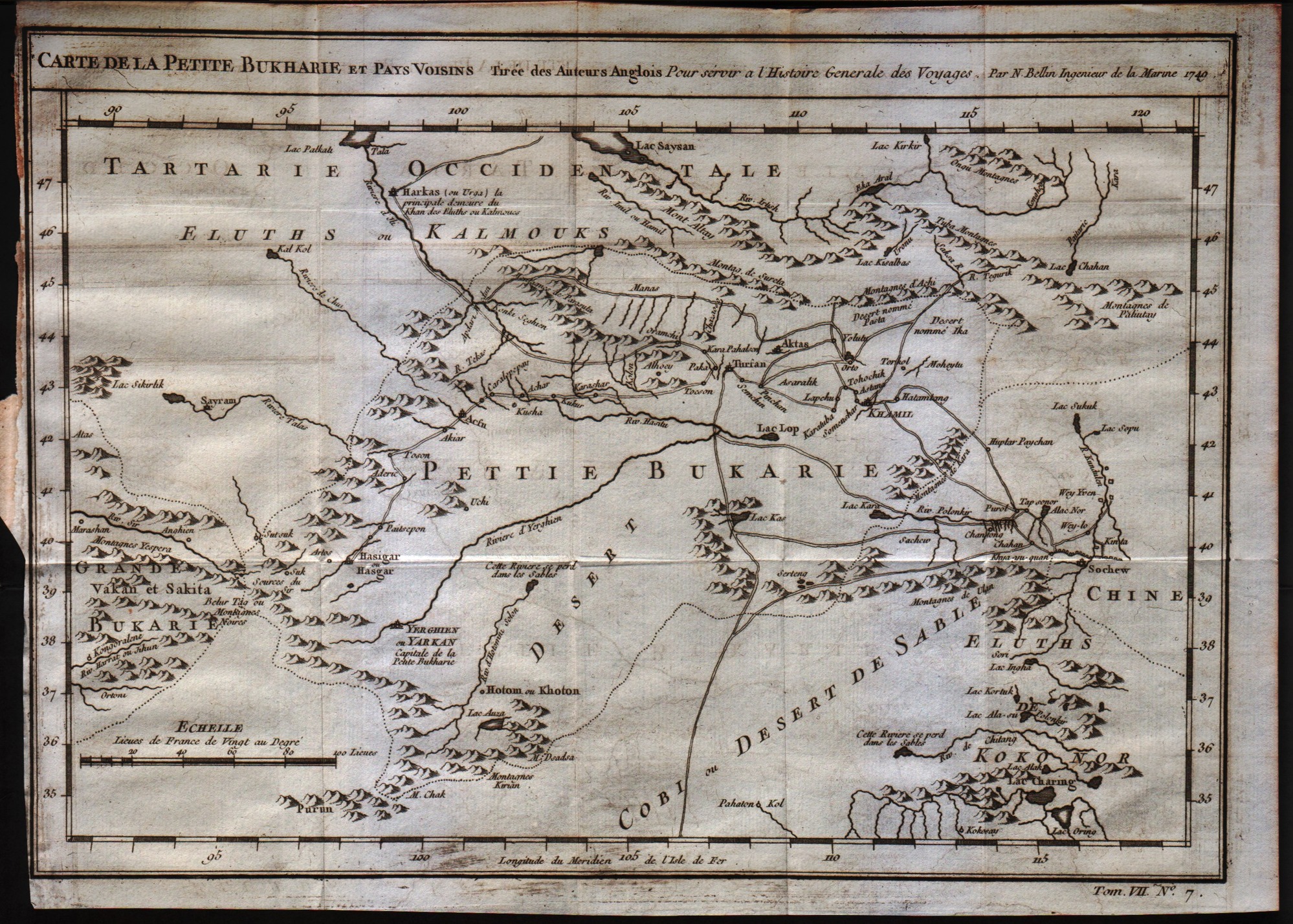
Map title
Carte de la petite Bukharie et pays voisin
Author
Bellin
Location shown in map
--
Edition date
1757
Edition place
Paris
Editor
--
Atlas
Historie General des Voyages -- Prevost
Price
Please ask: info@thetreasuremaps.com
State
[mint/EXCELLENT/very good/good/fair/mediocre/poor]
Color
Black/white
Verso
Blank
Size
Plate: cm (30.5 x 21.6) inches (12.01 x 8.5) Paper: cm (31.8 x 24.1) inches (12.52 x 9.49)
Technique
Copper engraving
Note
No particular notes for this maps
Reference
--
Wiki
Here for more info
In stock
Available
Info
info@thetreasuremaps.com
Code
#0227
×
![Carte de la petite Bukharie et pays voisin by Bellin, --, 1757]()
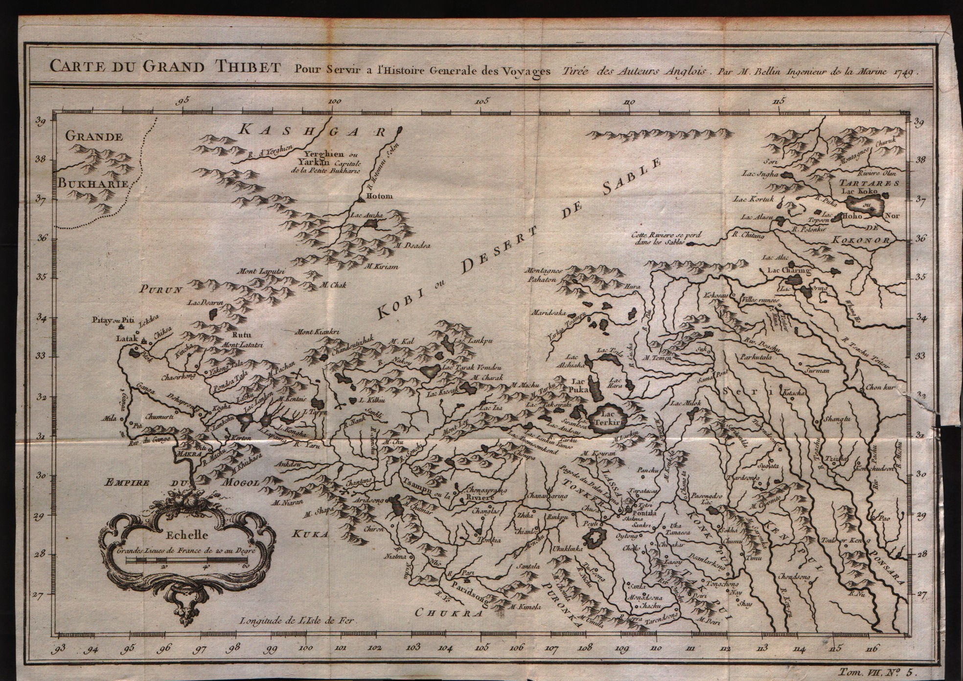
Map title
Carte du grand Thibet
Author
Bellin
Location shown in map
--
Edition date
1757
Edition place
Paris
Editor
--
Atlas
Historie General des Voyages -- Prevost
Price
Please ask: info@thetreasuremaps.com
State
[mint/EXCELLENT/very good/good/fair/mediocre/poor]
Color
Black/white
Verso
Blank
Size
Plate: cm (30.5 x 21.6) inches (12.01 x 8.5) Paper: cm (31.8 x 22.9) inches (12.52 x 9.02)
Technique
Copper engraving
Note
No particular notes for this maps
Reference
--
Wiki
Here for more info
In stock
Available
Info
info@thetreasuremaps.com
Code
#0236
×
![Carte du grand Thibet by Bellin, --, 1757]()
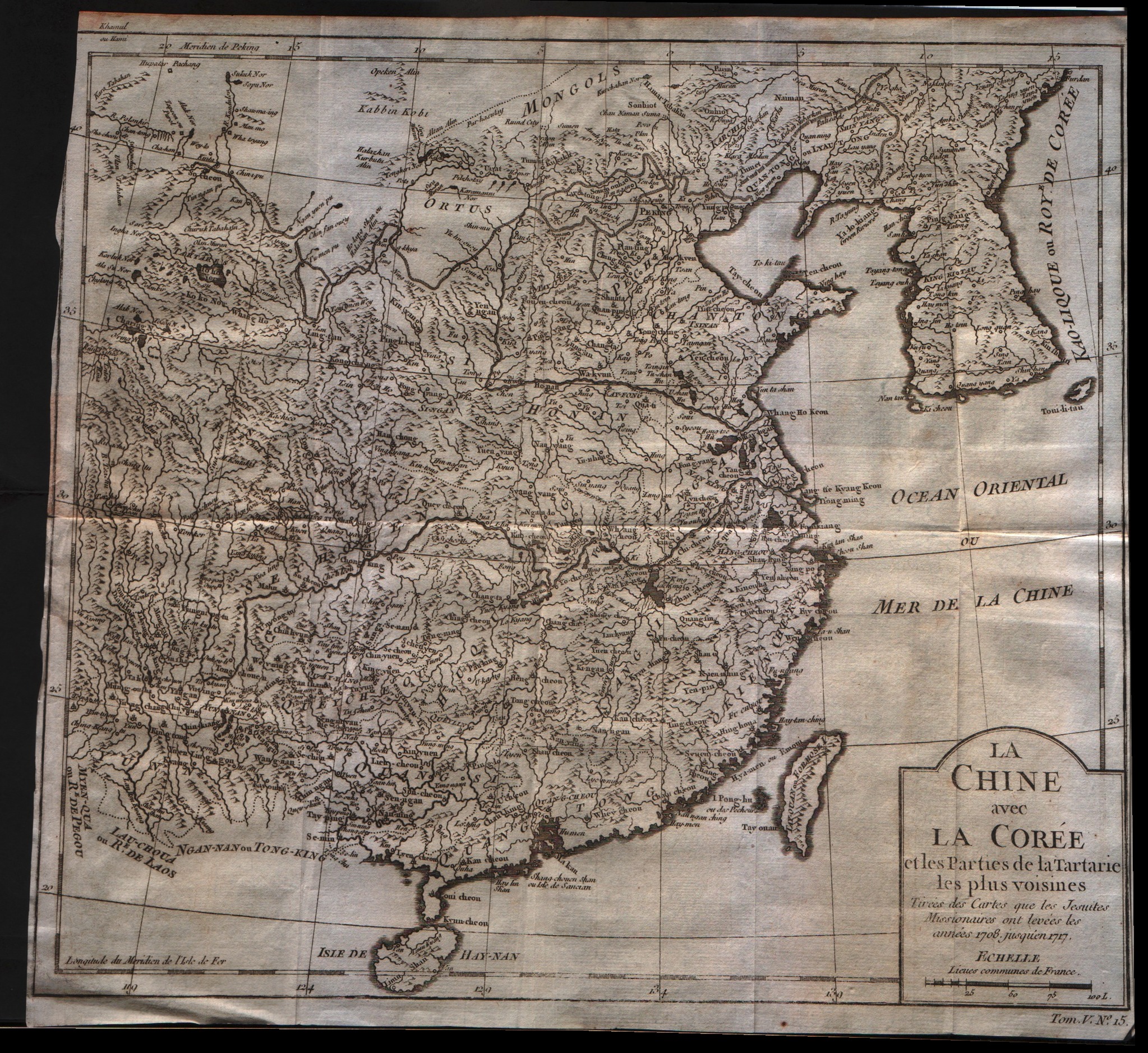
Map title
La Chine avec la Coree et les parties de la Tartarie les plus voisines
Author
Bellin
Location shown in map
China
Edition date
1757
Edition place
Paris
Editor
--
Atlas
Historie General des Voyages -- Prevost
Price
250 Euro
State
[mint/excellent/VERY GOOD/good/fair/mediocre/poor]
Color
Black/white
Verso
Blank
Size
Plate: cm (31.8 x 27.9) inches (12.52 x 10.98) Paper: cm (31.8 x 29.8) inches (12.52 x 11.73)
Technique
Copper engraving
Note
No particular notes for this maps
Reference
--
Wiki
Here for more info
In stock
Available
Info
info@thetreasuremaps.com
Code
#0243
×
![La Chine avec la Coree et les parties de la Tartarie les plus voisines by Bellin, China, 1757]()
Pages: 1 2