France
Pages: 1 2
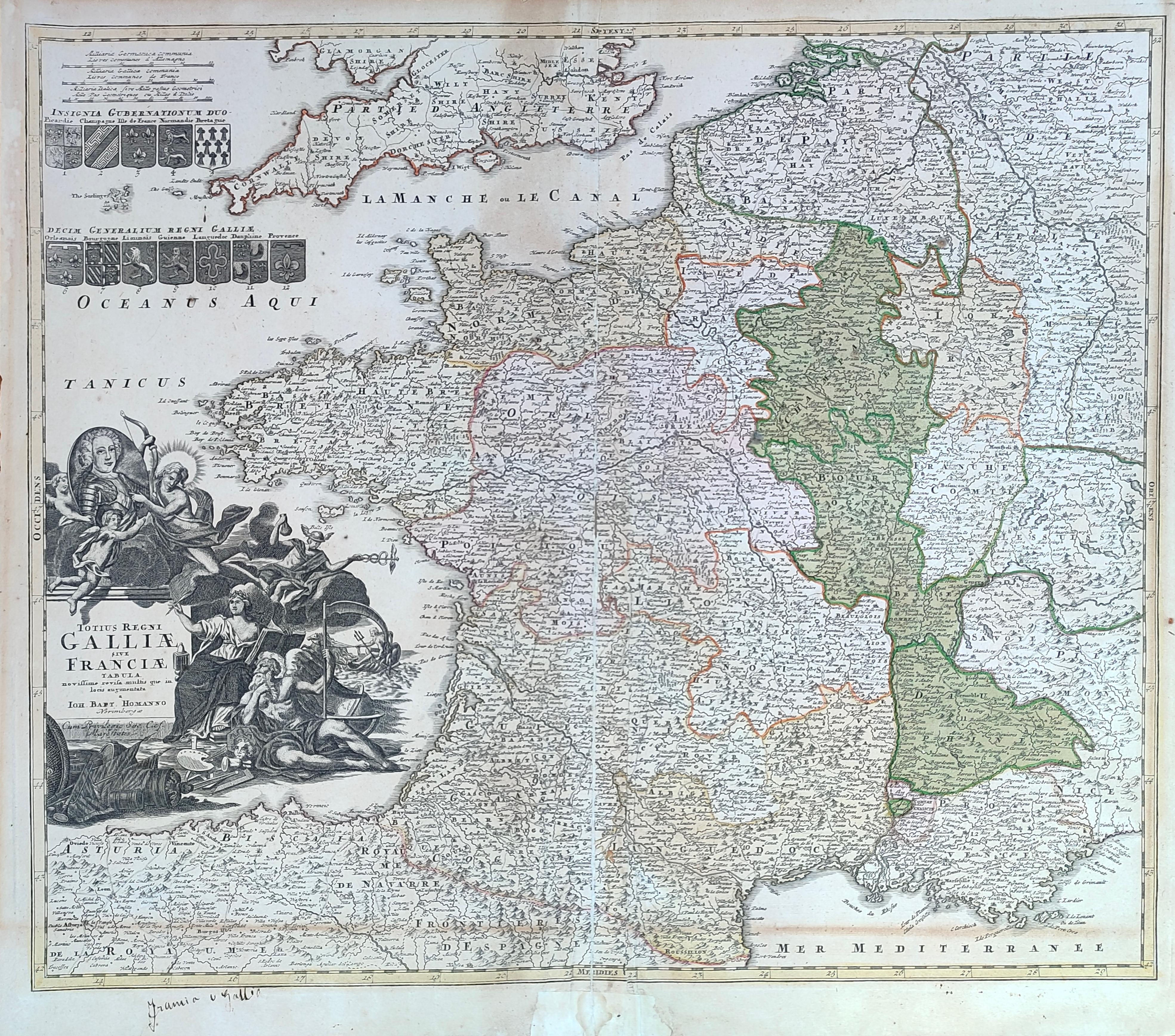
Map title
Totius regni Galliae sive Franciae tabula
Author
Homann
Location shown in map
France
Edition date
Circa 1720
Edition place
Nurimberg
Editor
--
Atlas
Price
200 Euro
State
[mint/excellent/VERY GOOD/good/fair/mediocre/poor]
Color
Old colors
Verso
Blank
Size
Plate: cm (58 x 48) inches (22.83 x 18.9) Paper: cm (59 x 52) inches (23.23 x 20.47)
Technique
Copper engraving
Note
Reference
Wiki
Here for more info
In stock
Available
Info
info@thetreasuremaps.com
Code
#1281
×
![Totius regni Galliae sive Franciae tabula by Homann, France, Circa 1720]()
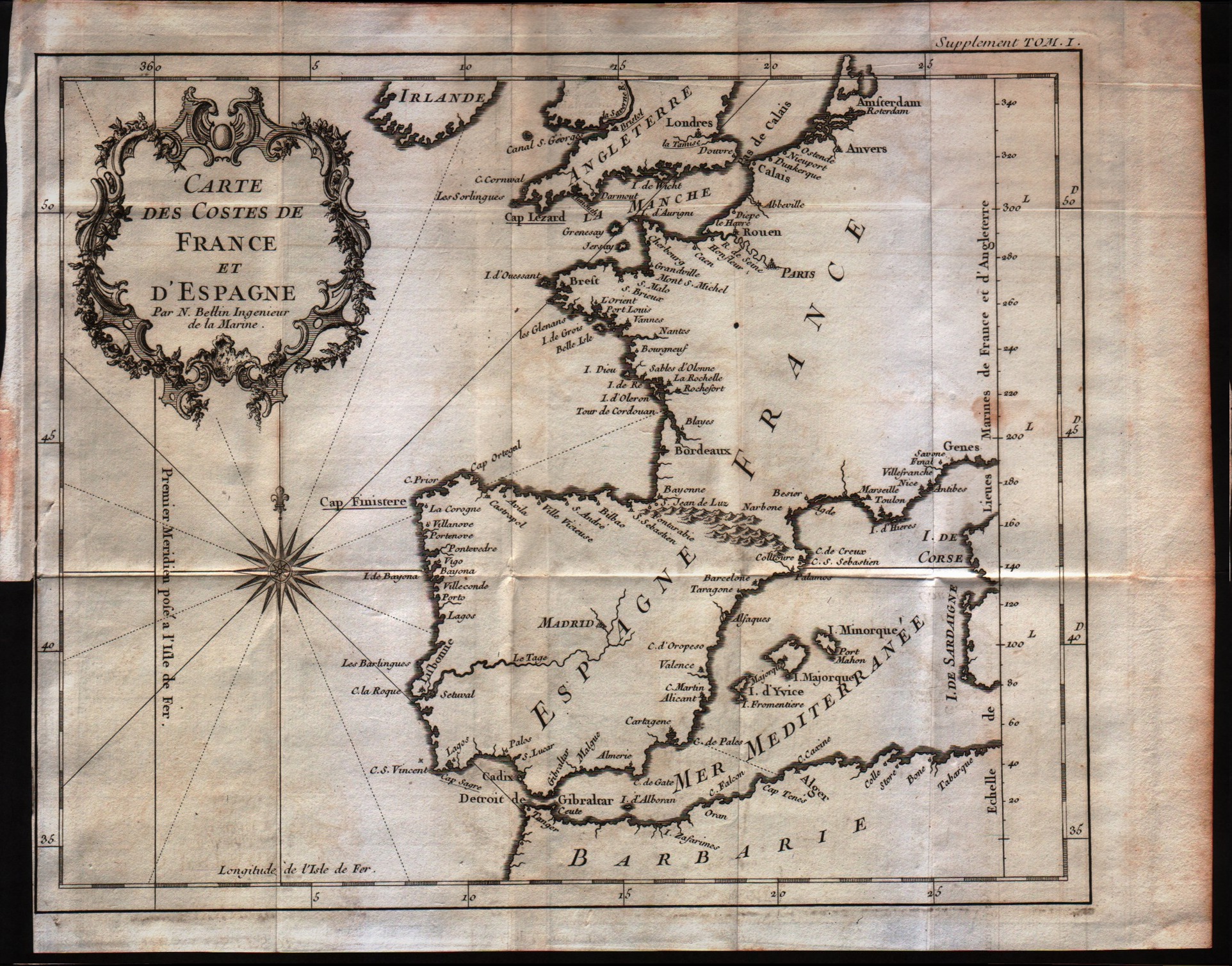
Map title
Carte des costes de France et d'Espagne
Author
Bellin
Location shown in map
France
Edition date
1757
Edition place
Paris
Editor
--
Atlas
Historie General des Voyages -- Prevost
Price
100 Euro
State
[mint/EXCELLENT/very good/good/fair/mediocre/poor]
Color
Black/white
Verso
Blank
Size
Plate: cm (31.8 x 21) inches (12.52 x 8.27) Paper: cm (36.8 x 25.4) inches (14.49 x 10)
Technique
Copper engraving
Note
No particular notes for this maps
Reference
--
Wiki
Here for more info
In stock
Available
Info
info@thetreasuremaps.com
Code
#0160
×
![Carte des costes de France et d'Espagne by Bellin, France, 1757]()

Map title
Carta geografica del regno di Corsica
Author
Tirion
Location shown in map
Corsica
Edition date
1762
Edition place
Venice
Editor
--
Atlas
Modern History printed by Thomas Salmon.
Price
250 Euro
State
[mint/excellent/VERY GOOD/good/fair/mediocre/poor]
Color
Black/white
Verso
Blank
Size
Plate: cm (43.2 x 33) inches (17.01 x 12.99) Paper: cm (48.3 x 36.8) inches (19.02 x 14.49)
Technique
Copper engraving
Note
Detailed map of the Corsica island.
Reference
--
Wiki
Here for more info
In stock
Sold
Info
info@thetreasuremaps.com
Code
#0402
×
![Carta geografica del regno di Corsica by Tirion, Corsica, 1762]()

Map title
La France divisee suivant ses Provinces ou Gouvernements Militaire. Par le S.r Robert Vaugondy Geographe
Author
Robert de Vaugondy
Location shown in map
France
Edition date
1771
Edition place
Paris
Editor
Delamarche
Atlas
Atlas moderne. Seconde partie.
Price
250 Euro
State
[mint/excellent/VERY GOOD/good/fair/mediocre/poor]
Color
Old outlined
Verso
Blank
Size
Plate: cm (71 x 50) inches (27.95 x 19.69) Paper: cm (74 x 51) inches (29.13 x 20.08)
Technique
Copper engraving
Note
Reference
Wiki
Here for more info
In stock
Available
Info
info@thetreasuremaps.com
Code
#0772
×
![La France divisee suivant ses Provinces ou Gouvernements Militaire. Par le S.r Robert Vaugondy Geographe by Robert de Vaugondy, France, 1771]()
Map title
Carte de France
Author
Bonne
Location shown in map
France
Edition date
1787
Edition place
Paris
Editor
--
Atlas
Atlas Encyclopedique
Price
Please ask: info@thetreasuremaps.com
State
[mint/excellent/very good/good/FAIR/mediocre/poor]
Color
Modern outlined
Verso
Blank
Size
Plate: cm (27.9 x 22.9) inches (10.98 x 9.02) Paper: cm (30.5 x 25.4) inches (12.01 x 10)
Technique
Copper engraving
Note
No particular notes for this maps
Reference
--
Wiki
Here for more info
In stock
Sold
Info
info@thetreasuremaps.com
Code
#0168
×
![Carte de France by Bonne, France, 1787]()
Map title
Governament de la Bretagne
Author
Bonne
Location shown in map
--
Edition date
1787
Edition place
Paris
Editor
--
Atlas
Atlas Encyclopedique
Price
Please ask: info@thetreasuremaps.com
State
[mint/excellent/VERY GOOD/good/fair/mediocre/poor]
Color
Black/white
Verso
Blank
Size
Plate: cm (31.8 x 21) inches (12.52 x 8.27) Paper: cm (36.8 x 25.4) inches (14.49 x 10)
Technique
Copper engraving
Note
No particular notes for this maps
Reference
--
Wiki
Here for more info
In stock
Sold
Info
info@thetreasuremaps.com
Code
#0427
×
![Governament de la Bretagne by Bonne, --, 1787]()
Map title
France
Author
Monin
Location shown in map
France
Edition date
1840
Edition place
Paris
Editor
Atlas
Atlas Classique de la Geographie
Price
50 Euro
State
[mint/EXCELLENT/very good/good/fair/mediocre/poor]
Color
Old colors
Verso
Blank
Size
Plate: cm (39 x 28) inches (15.35 x 11.02) Paper: cm (45 x 33) inches (17.72 x 12.99)
Technique
Copper engraving
Note
Reference
Wiki
Here for more info
In stock
Available
Info
info@thetreasuremaps.com
Code
#1038
France
Author
Monin
Location shown in map
France
Edition date
1840
Edition place
Paris
Editor
Atlas
Atlas Classique de la Geographie
Price
50 Euro
State
[mint/EXCELLENT/very good/good/fair/mediocre/poor]
Color
Old colors
Verso
Blank
Size
Plate: cm (39 x 28) inches (15.35 x 11.02) Paper: cm (45 x 33) inches (17.72 x 12.99)
Technique
Copper engraving
Note
Reference
Wiki
Here for more info
In stock
Available
Info
info@thetreasuremaps.com
Code
#1038
×
![France by Monin, France, 1840]()
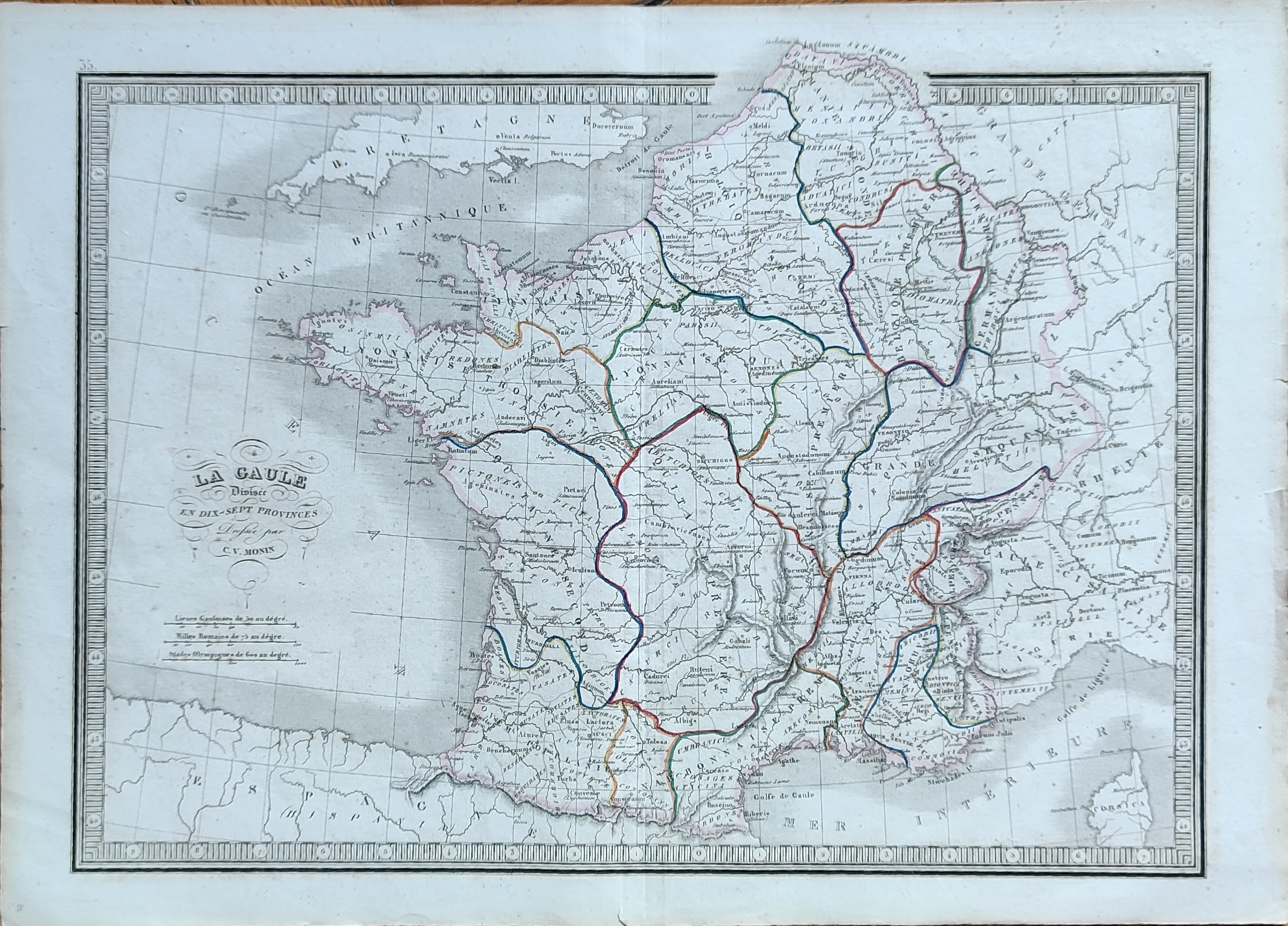
Map title
La Gaule
Author
Monin
Location shown in map
France
Edition date
1840
Edition place
Paris
Editor
Atlas
Atlas Classique de la Geographie
Price
50 Euro
State
[mint/EXCELLENT/very good/good/fair/mediocre/poor]
Color
Old colors
Verso
Blank
Size
Plate: cm (39 x 28) inches (15.35 x 11.02) Paper: cm (45 x 33) inches (17.72 x 12.99)
Technique
Copper engraving
Note
Reference
Wiki
Here for more info
In stock
Available
Info
info@thetreasuremaps.com
Code
#1050
×
![La Gaule by Monin, France, 1840]()
Map title
Le vie ferrate e le postali della Francia settentrionale e della Belgica
Author
Unknown
Location shown in map
North France
Edition date
1858
Edition place
Genoa
Editor
--
Atlas
Atlante di geografia universale. Paolo Rivara
Price
Please ask: info@thetreasuremaps.com
State
[mint/EXCELLENT/very good/good/fair/mediocre/poor]
Color
Old outlined
Verso
Blank
Size
Plate: cm (33 x 26.7) inches (12.99 x 10.51) Paper: cm (50.8 x 38.1) inches (20 x 15)
Technique
Steel engraving
Note
No particular notes for this maps
Reference
--
Wiki
Here for more info
In stock
Sold
Info
info@thetreasuremaps.com
Code
#0496
×
![Le vie ferrate e le postali della Francia settentrionale e della Belgica by Unknown, North France, 1858]()
Pages: 1 2