Greece
Map title
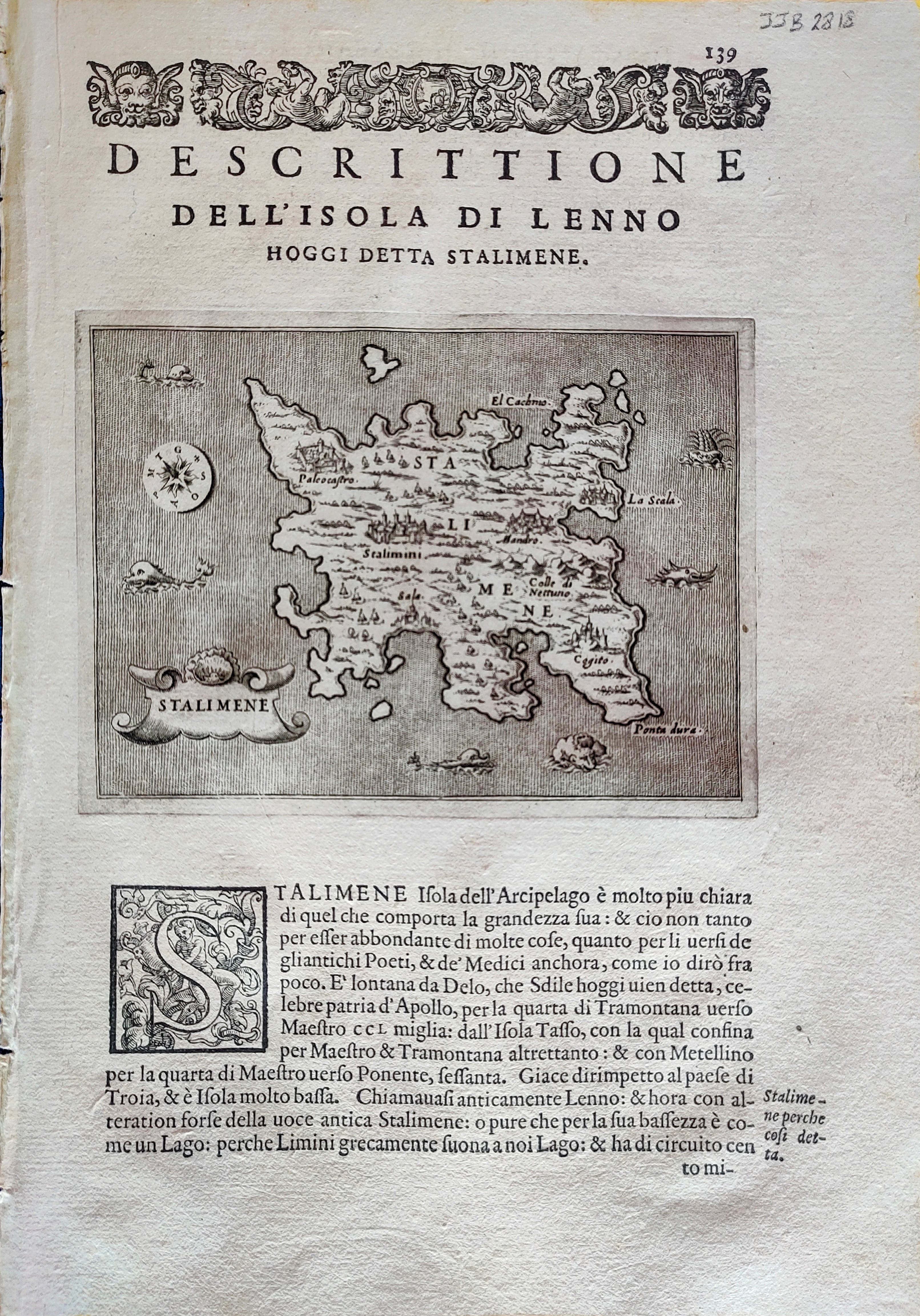
Descrittione dell'isola di Lenno
Author
Porcacchi
Location shown in map
Lemnos
Edition date
1576
Edition place
Venice
Editor
--
Atlas
L'Isole piu famose del mondo -- S. Galignani and G. Porro
Price
Please ask: info@thetreasuremaps.com
State
[mint/EXCELLENT/very good/good/fair/mediocre/poor]
Color
Black/white
Verso
Italian text pag.140
Size
Plate: cm (15.2 x 11.4) inches (5.98 x 4.49) Paper: cm (20.3 x 28) inches (7.99 x 11.02)
Technique
Copper engraving
Note
Reference
--
Wiki
Here for more info
In stock
Available
Info
info@thetreasuremaps.com
Code
#0899
×
![Descrittione dell'isola di Lenno by Porcacchi, Lemnos, 1576]()
Map title
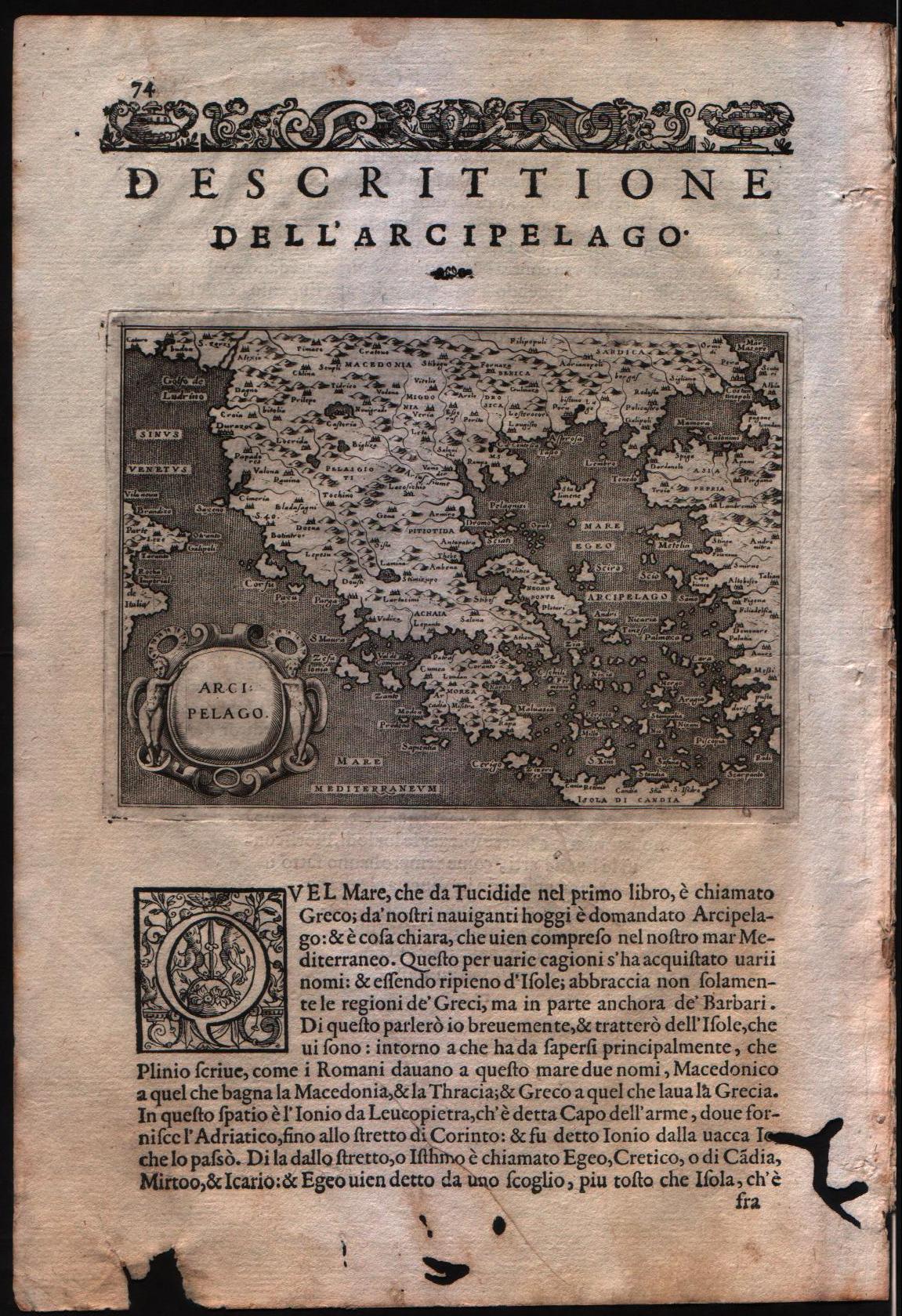
Descrittione dell'arcipelago
Author
Porcacchi
Location shown in map
Greece
Edition date
1576
Edition place
Venice
Editor
--
Atlas
L'Isole piu famose del mondo -- S. Galignani and G. Porro
Price
Please ask: info@thetreasuremaps.com
State
[MINT/excellent/very good/good/fair/mediocre/poor]
Color
Black/white
Verso
Italian text pag.74
Size
Plate: cm (15.2 x 11.4) inches (5.98 x 4.49) Paper: cm (19 x 29.2) inches (7.48 x 11.5)
Technique
Copper engraving
Note
No particular notes for this maps
Reference
Genoa pubblic library "Civica Berio"
Wiki
Here for more info
In stock
Available
Info
info@thetreasuremaps.com
Code
#0105
×
![Descrittione dell'arcipelago by Porcacchi, Greece, 1576]()
Map title
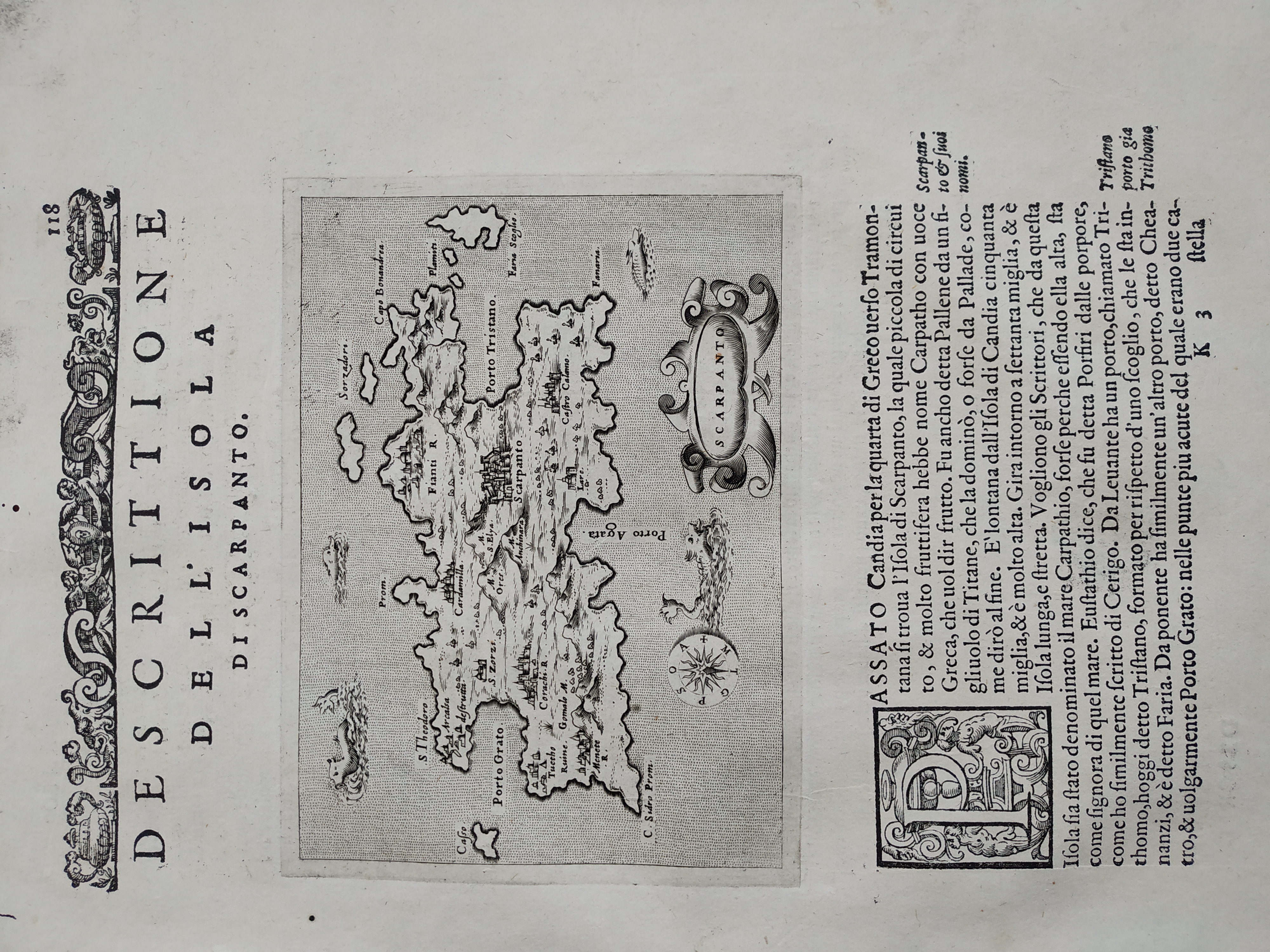
Descrittione dell'isola di Scarpanto
Author
Porcacchi
Location shown in map
Scarpanto
Edition date
1576
Edition place
Venice
Editor
--
Atlas
L'Isole piu famose del mondo -- S. Galignani and G. Porro
Price
Please ask: info@thetreasuremaps.com
State
[MINT/excellent/very good/good/fair/mediocre/poor]
Color
Black/white
Verso
Italian text pag.114
Size
Plate: cm (15.2 x 11.4) inches (5.98 x 4.49) Paper: cm (19 x 27.9) inches (7.48 x 10.98)
Technique
Copper engraving
Note
No particular notes for this maps
Reference
Genoa pubblic library "Civica Berio"
Wiki
Here for more info
In stock
Available
Info
info@thetreasuremaps.com
Code
#0834
×
![Descrittione dell'isola di Scarpanto by Porcacchi, Scarpanto, 1576]()
Map title
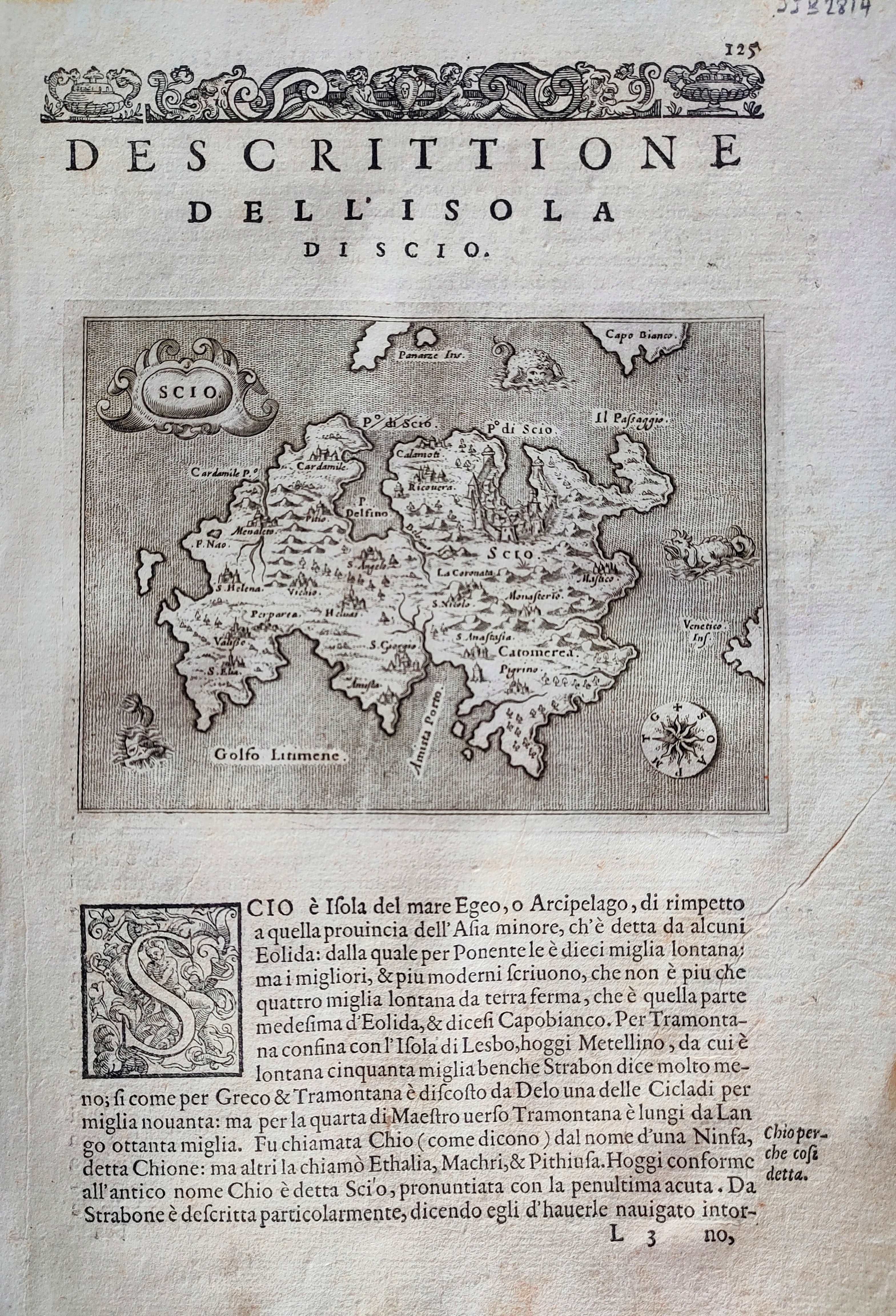
Descrittione dell'isola di Scio
Author
Porcacchi
Location shown in map
Scio
Edition date
1576
Edition place
Venice
Editor
--
Atlas
L'Isole piu famose del mondo -- S. Galignani and G. Porro
Price
Please ask: info@thetreasuremaps.com
State
[mint/EXCELLENT/very good/good/fair/mediocre/poor]
Color
Black/white
Verso
Italian text pag.126
Size
Plate: cm (15.2 x 11.4) inches (5.98 x 4.49) Paper: cm (20.3 x 29.2) inches (7.99 x 11.5)
Technique
Copper engraving
Note
Reference
--
Wiki
Here for more info
In stock
Available
Info
info@thetreasuremaps.com
Code
#0867
×
![Descrittione dell'isola di Scio by Porcacchi, Scio, 1576]()
Map title
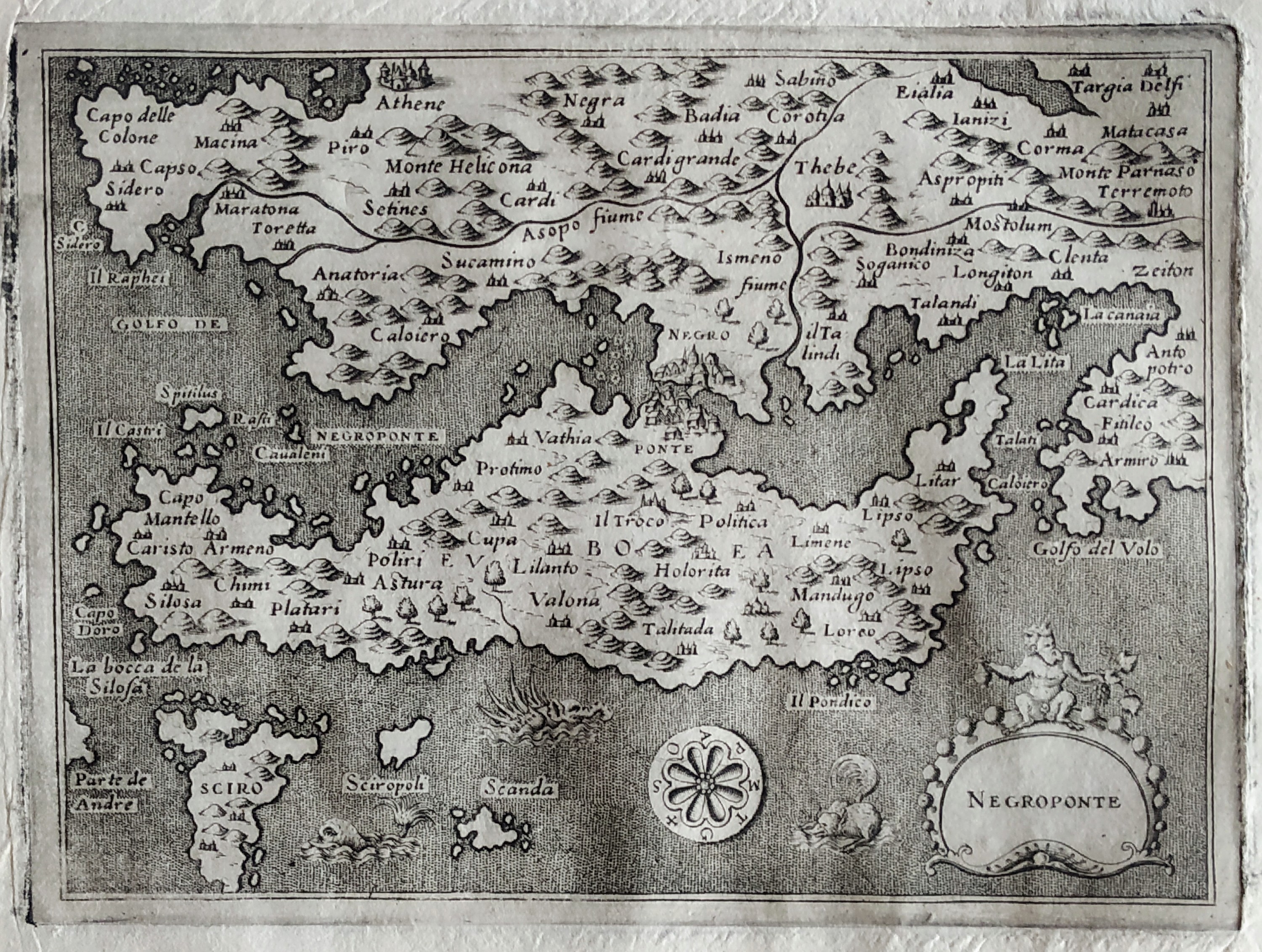
Descrittione dell'isola Negroponte
Author
Porcacchi
Location shown in map
Euboea
Edition date
1576
Edition place
Venice
Editor
--
Atlas
L'Isole piu famose del mondo -- S. Galignani and G. Porro
Price
Please ask: info@thetreasuremaps.com
State
[MINT/excellent/very good/good/fair/mediocre/poor]
Color
Black/white
Verso
Italian text pag.141
Size
Plate: cm (15.2 x 11.4) inches (5.98 x 4.49) Paper: cm (19 x 27.9) inches (7.48 x 10.98)
Technique
Copper engraving
Note
No particular notes for this maps
Reference
Genoa pubblic library "Civica Berio"
Wiki
Here for more info
In stock
Available
Info
info@thetreasuremaps.com
Code
#0800
×
![Descrittione dell'isola Negroponte by Porcacchi, Euboea, 1576]()
Map title
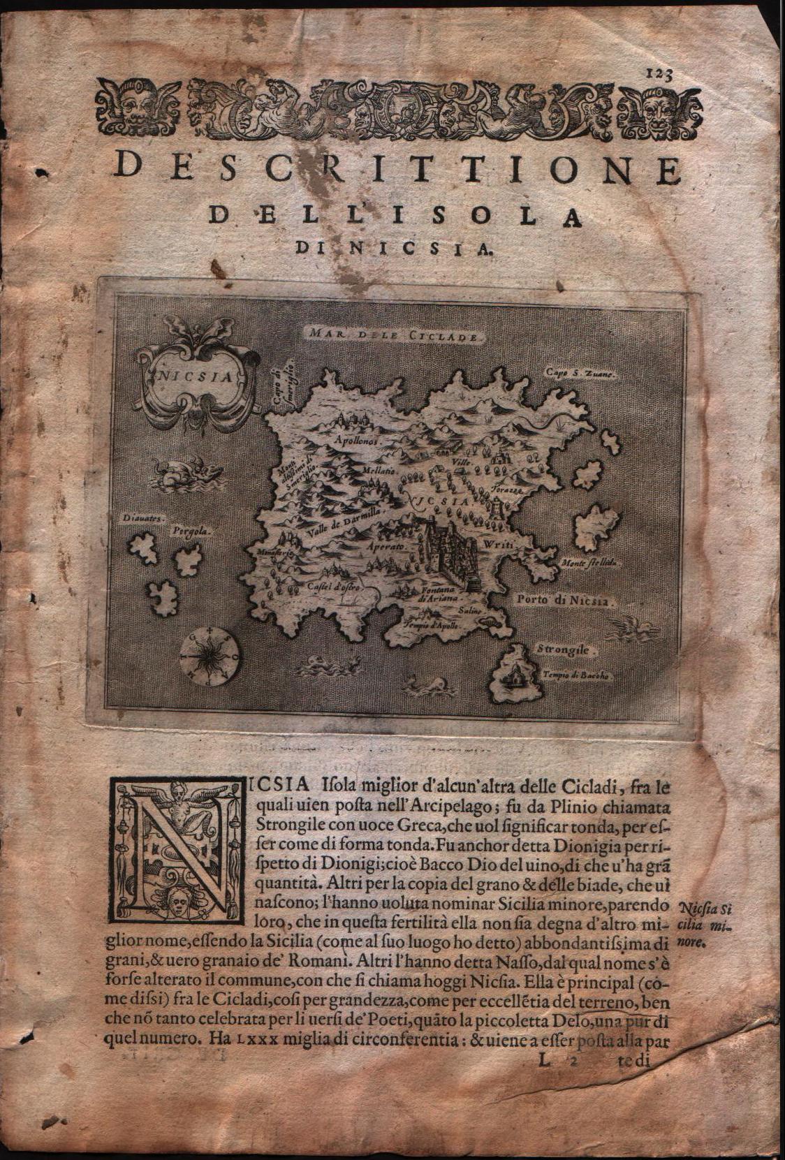
Descrittione dell'isola di Nicsia
Author
Porcacchi
Location shown in map
Naxos island
Edition date
1576
Edition place
Venice
Editor
--
Atlas
L'Isole piu famose del mondo -- S. Galignani and G. Porro
Price
Please ask: info@thetreasuremaps.com
State
[mint/excellent/VERY GOOD/good/fair/mediocre/poor]
Color
Black/white
Verso
Italian text pag.124
Size
Plate: cm (15.2 x 11.4) inches (5.98 x 4.49) Paper: cm (19 x 29.2) inches (7.48 x 11.5)
Technique
Copper engraving
Note
No particular notes for this maps
Reference
Genoa pubblic library "Civica Berio"
Wiki
Here for more info
In stock
Available
Info
info@thetreasuremaps.com
Code
#0107
×
![Descrittione dell'isola di Nicsia by Porcacchi, Naxos island, 1576]()
Map title
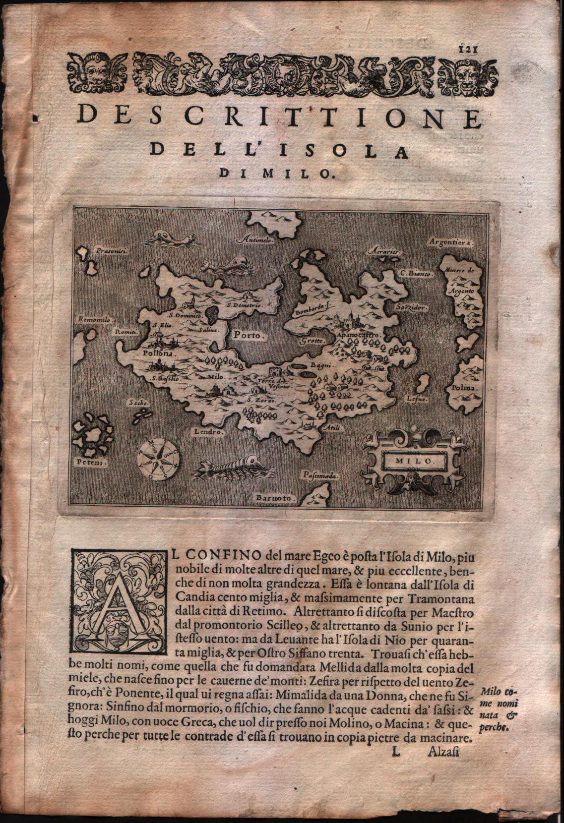
Descrittione dell'isola di Milo
Author
Porcacchi
Location shown in map
Milo island
Edition date
1576
Edition place
Venice
Editor
--
Atlas
L'Isole piu famose del mondo -- S. Galignani and G. Porro
Price
Please ask: info@thetreasuremaps.com
State
[mint/EXCELLENT/very good/good/fair/mediocre/poor]
Color
Black/white
Verso
Italian text pag.122
Size
Plate: cm (15.2 x 11.4) inches (5.98 x 4.49) Paper: cm (19 x 29.2) inches (7.48 x 11.5)
Technique
Copper engraving
Note
No particular notes for this maps
Reference
Genoa pubblic library "Civica Berio"
Wiki
Here for more info
In stock
Available
Info
info@thetreasuremaps.com
Code
#0108
×
![Descrittione dell'isola di Milo by Porcacchi, Milo island, 1576]()

Map title
Descrittione dell'isola di Stalimene
Author
Porcacchi
Location shown in map
Lemno island
Edition date
1576
Edition place
Venice
Editor
--
Atlas
L'Isole piu famose del mondo -- S. Galignani and G. Porro
Price
Please ask: info@thetreasuremaps.com
State
[mint/EXCELLENT/Vvery good/good/fair/mediocre/poor]
Color
Black/white
Verso
Italian text pag.140
Size
Plate: cm (15.2 x 11.4) inches (5.98 x 4.49) Paper: cm (19 x 29.2) inches (7.48 x 11.5)
Technique
Copper engraving
Note
No particular notes for this maps
Reference
Genoa pubblic library "Civica Berio"
Wiki
Here for more info
In stock
Sold
Info
info@thetreasuremaps.com
Code
#0110
×
![Descrittione dell'isola di Stalimene by Porcacchi, Lemno island, 1576]()
Map title
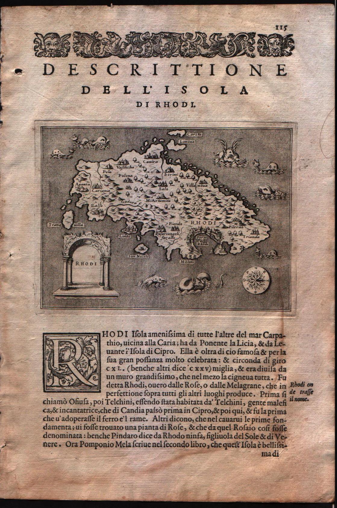
Descrittione dell'isola di Rhodi
Author
Porcacchi
Location shown in map
Rhodi island
Edition date
1576
Edition place
Venice
Editor
--
Atlas
L'Isole piu famose del mondo -- S. Galignani and G. Porro
Price
Please ask: info@thetreasuremaps.com
State
[mint/EXCELLENT/very good/good/fair/mediocre/poor]
Color
Black/white
Verso
Italian text pag.122
Size
Plate: cm (15.2 x 11.4) inches (5.98 x 4.49) Paper: cm (19 x 29.2) inches (7.48 x 11.5)
Technique
Copper engraving
Note
No particular notes for this maps
Reference
Genoa pubblic library "Civica Berio"
Wiki
Here for more info
In stock
Available
Info
info@thetreasuremaps.com
Code
#0109
×
![Descrittione dell'isola di Rhodi by Porcacchi, Rhodi island, 1576]()
Map title
Descrittione dell'isola di Cipro
Author
Porcacchi
Location shown in map
Cyprus
Edition date
1590
Edition place
Venice
Editor
Gagliani
Atlas
L'Isole piu famose del mondo -- S. Galignani and G. Porro
Price
350 Euro
State
[MINT/excellent/very good/good/fair/mediocre/poor]
Color
Black/white
Verso
Italian text pag.143
Size
Plate: cm (15.2 x 11.4) inches (5.98 x 4.49) Paper: cm (19 x 27.9) inches (7.48 x 10.98)
Technique
Copper engraving
Note
Reference
Genoa pubblic library "Civica Berio"
Wiki
Here for more info
In stock
Available
Info
info@thetreasuremaps.com
Code
#0978
×
![Descrittione dell'isola di Cipro by Porcacchi, Cyprus, 1590]()
Map title
Descrittione del conflitto navale successo a Curzolari
Author
Porcacchi
Location shown in map
Curzolari
Edition date
1590
Edition place
Venice
Editor
Gagliani
Atlas
L'Isole piu famose del mondo -- S. Galignani and G. Porro
Price
Please ask: info@thetreasuremaps.com
State
[MINT/excellent/very good/good/fair/mediocre/poor]
Color
Black/white
Verso
Italian text pag.88
Size
Plate: cm (15.2 x 11.4) inches (5.98 x 4.49) Paper: cm (19 x 27.9) inches (7.48 x 10.98)
Technique
Copper engraving
Note
Reference
Genoa pubblic library "Civica Berio"
Wiki
Here for more info
In stock
Available
Info
info@thetreasuremaps.com
Code
#0974
×
![Descrittione del conflitto navale successo a Curzolari by Porcacchi, Curzolari, 1590]()
Map title
Descrittione dell'isola di Candia
Author
Porcacchi
Location shown in map
Crete
Edition date
1590
Edition place
Venice
Editor
Gagliani
Atlas
L'Isole piu famose del mondo -- S. Galignani and G. Porro
Price
Please ask: info@thetreasuremaps.com
State
[MINT/excellent/very good/good/fair/mediocre/poor]
Color
Black/white
Verso
Italian text pag.107
Size
Plate: cm (15.2 x 11.4) inches (5.98 x 4.49) Paper: cm (19 x 27.9) inches (7.48 x 10.98)
Technique
Copper engraving
Note
Reference
Genoa pubblic library "Civica Berio"
Wiki
Here for more info
In stock
Available
Info
info@thetreasuremaps.com
Code
#0975
×
![Descrittione dell'isola di Candia by Porcacchi, Crete, 1590]()
Map title
Descrittione dell'isola di Lenno
Author
Porcacchi
Location shown in map
Lemno island
Edition date
1590
Edition place
Venice
Editor
Gagliani
Atlas
L'Isole piu famose del mondo -- S. Galignani and G. Porro
Price
Please ask: info@thetreasuremaps.com
State
[MINT/excellent/very good/good/fair/mediocre/poor]
Color
Black/white
Verso
Italian text pag.140
Size
Plate: cm (15.2 x 11.4) inches (5.98 x 4.49) Paper: cm (19 x 27.9) inches (7.48 x 10.98)
Technique
Copper engraving
Note
Reference
Genoa pubblic library "Civica Berio"
Wiki
Here for more info
In stock
Available
Info
info@thetreasuremaps.com
Code
#0976
×
![Descrittione dell'isola di Lenno by Porcacchi, Lemno island, 1590]()
Map title
Descrittione dell'isola di Negroponte
Author
Porcacchi
Location shown in map
Euboea
Edition date
1590
Edition place
Venice
Editor
Gagliani
Atlas
L'Isole piu famose del mondo -- S. Galignani and G. Porro
Price
Please ask: info@thetreasuremaps.com
State
[MINT/excellent/very good/good/fair/mediocre/poor]
Color
Black/white
Verso
Italian text pag.141
Size
Plate: cm (15.2 x 11.4) inches (5.98 x 4.49) Paper: cm (19 x 27.9) inches (7.48 x 10.98)
Technique
Copper engraving
Note
Reference
Genoa pubblic library "Civica Berio"
Wiki
Here for more info
In stock
Available
Info
info@thetreasuremaps.com
Code
#0977
×
![Descrittione dell'isola di Negroponte by Porcacchi, Euboea, 1590]()
Map title
Descrittione dell'arcipelago
Author
Porcacchi
Location shown in map
Greece
Edition date
1602
Edition place
Venice
Editor
--
Atlas
L'Isole piu famose del mondo -- S. Galignani and G. Porro
Price
200 Euro
State
[MINT/excellent/very good/good/fair/mediocre/poor]
Color
Black/white
Verso
Italian text pag.74
Size
Plate: cm (15.2 x 11.4) inches (5.98 x 4.49) Paper: cm (19 x 29.2) inches (7.48 x 11.5)
Technique
Copper engraving
Note
No particular notes for this maps
Reference
--
Wiki
Here for more info
In stock
Available
Info
info@thetreasuremaps.com
Code
#0106
×
![Descrittione dell'arcipelago by Porcacchi, Greece, 1602]()
Map title
Descrittione dell'isola di Creta, o di Candia
Author
Magini
Location shown in map
Crete island
Edition date
1621
Edition place
Padova
Editor
Paolo and Francesco Galignani
Atlas
Geografia di Claudio Tolomeo -- Giovanni Antonio Magini
Price
200 Euro
State
[MINT/excellent/very good/good/fair/mediocre/poor]
Color
Black/white
Verso
Italian text pag 128
Size
Plate: cm (12.7 x 17.8) inches (5 x 7.01) Paper: cm (20.3 x 30.5) inches (7.99 x 12.01)
Technique
Copper engraving
Note
No particular notes for this maps.
Reference
--
Wiki
Here for more info
In stock
Available
Info
info@thetreasuremaps.com
Code
#0131
×
![Descrittione dell'isola di Creta, o di Candia by Magini, Crete island, 1621]()
Map title
Candia olim Creta
Author
Doglioni
Location shown in map
Crete
Edition date
1623
Edition place
Venice
Editor
Giacomo Sarzina
Atlas
Anfiteatro di Europa
Price
Please ask: info@thetreasuremaps.com
State
[mint/EXCELLENT/very good/good/fair/mediocre/poor]
Color
Black/white
Verso
Italian text pag.1158
Size
Plate: cm (11.4 x 8.9) inches (4.49 x 3.5) Paper: cm (15.2 x 22.9) inches (5.98 x 9.02)
Technique
Copper engraving
Note
The maps are copies of the Galle (c.1595) edition of Ortelius.
Reference
--
Wiki
Here for more info
In stock
Available
Info
info@thetreasuremaps.com
Code
#0621
×
![Candia olim Creta by Doglioni, Crete, 1623]()
Map title
Graecia
Author
Doglioni
Location shown in map
Greece
Edition date
1623
Edition place
Venice
Editor
Giacomo Sarzina
Atlas
Anfiteatro di Europa
Price
Please ask: info@thetreasuremaps.com
State
[mint/EXCELLENT/very good/good/fair/mediocre/poor]
Color
Black/white
Verso
Italian text pag.1092
Size
Plate: cm (11.4 x 8.9) inches (4.49 x 3.5) Paper: cm (15.2 x 22.9) inches (5.98 x 9.02)
Technique
Copper engraving
Note
The maps are copies of the Galle (c.1595) edition of Ortelius.
Reference
--
Wiki
Here for more info
In stock
Available
Info
info@thetreasuremaps.com
Code
#0613
×
![Graecia by Doglioni, Greece, 1623]()
Map title
Corfu
Author
Doglioni
Location shown in map
Corfu
Edition date
1623
Edition place
Venice
Editor
Giacomo Sarzina
Atlas
Anfiteatro di Europa
Price
Please ask: info@thetreasuremaps.com
State
[mint/EXCELLENT/very good/good/fair/mediocre/poor]
Color
Black/white
Verso
Italian text pag.1095
Size
Plate: cm (11.4 x 8.9) inches (4.49 x 3.5) Paper: cm (15.2 x 22.9) inches (5.98 x 9.02)
Technique
Copper engraving
Note
The maps are copies of the Galle (c.1595) edition of Ortelius.
Reference
--
Wiki
Here for more info
In stock
Available
Info
info@thetreasuremaps.com
Code
#0612
Corfu
Author
Doglioni
Location shown in map
Corfu
Edition date
1623
Edition place
Venice
Editor
Giacomo Sarzina
Atlas
Anfiteatro di Europa
Price
Please ask: info@thetreasuremaps.com
State
[mint/EXCELLENT/very good/good/fair/mediocre/poor]
Color
Black/white
Verso
Italian text pag.1095
Size
Plate: cm (11.4 x 8.9) inches (4.49 x 3.5) Paper: cm (15.2 x 22.9) inches (5.98 x 9.02)
Technique
Copper engraving
Note
The maps are copies of the Galle (c.1595) edition of Ortelius.
Reference
--
Wiki
Here for more info
In stock
Available
Info
info@thetreasuremaps.com
Code
#0612
×
![Corfu by Doglioni, Corfu, 1623]()
Map title
Cyprus insula
Author
Blaeu
Location shown in map
Cyprus
Edition date
Circa 1640
Edition place
Amsterdam
Editor
Blaeu
Atlas
Theatrum Orbis Terrarum, Sive Atlas Novis
Price
1100 Euro
State
[mint/EXCELLENT/very good/good/fair/mediocre/poor]
Color
Old colors
Verso
Dutch text
Size
Plate: cm (50 x 38) inches (19.69 x 14.96) Paper: cm (56 x 44) inches (22.05 x 17.32)
Technique
Copper engraving
Note
Reference
--
Wiki
Here for more info
In stock
Available
Info
info@thetreasuremaps.com
Code
#1071
×
![Cyprus insula by Blaeu, Cyprus, Circa 1640]()