India-Ceylon
Pages: 1 2
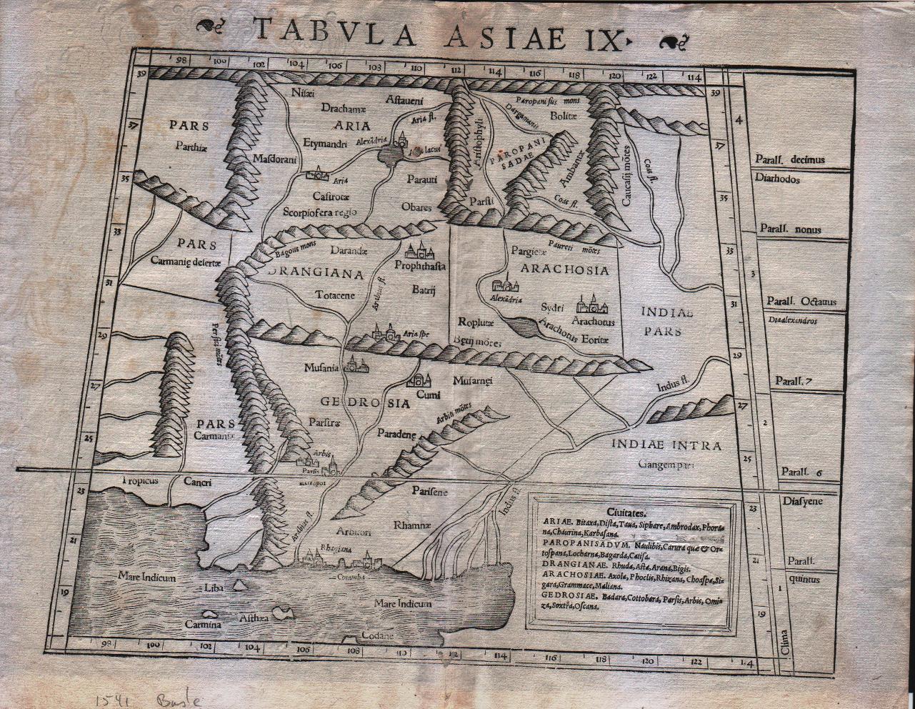
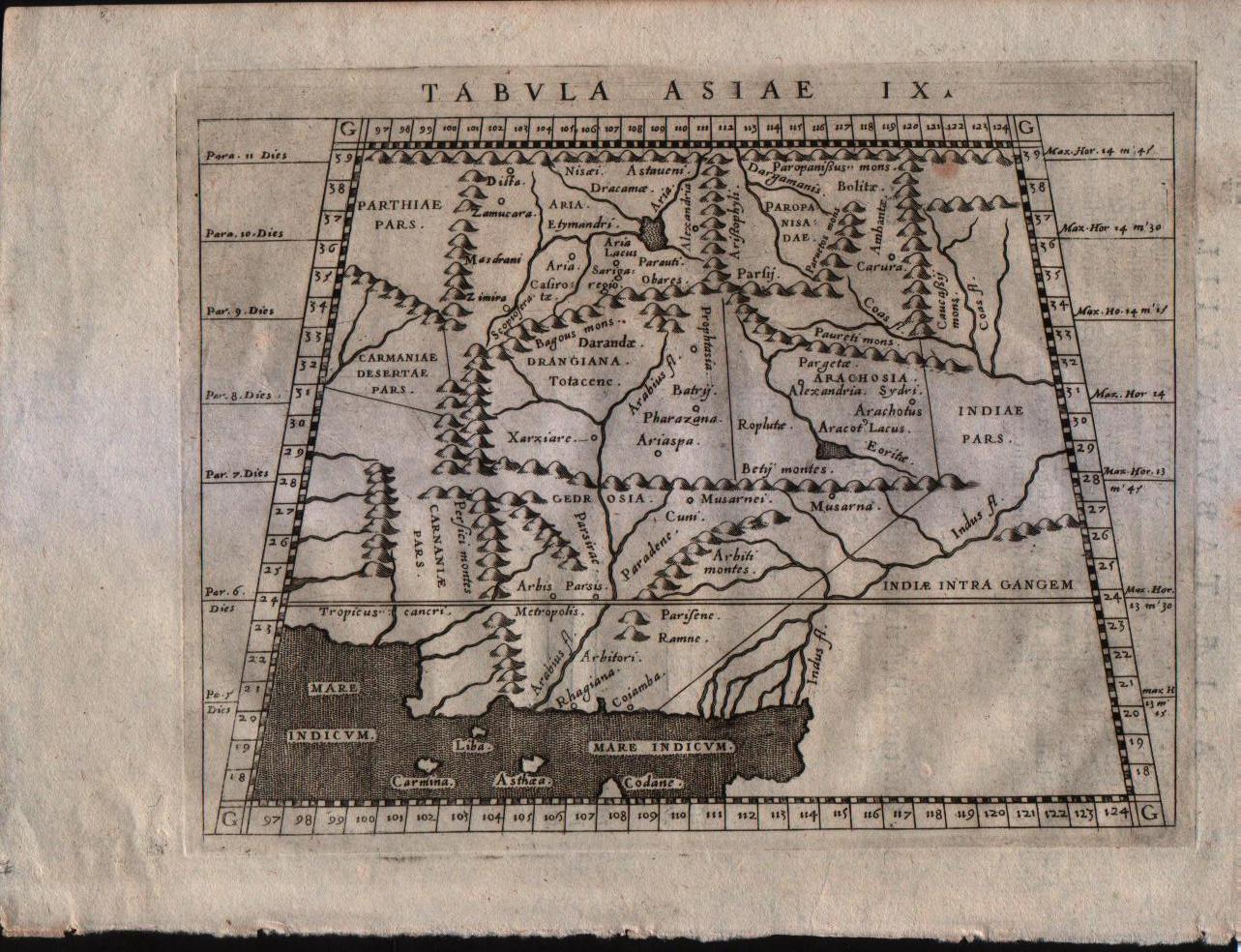
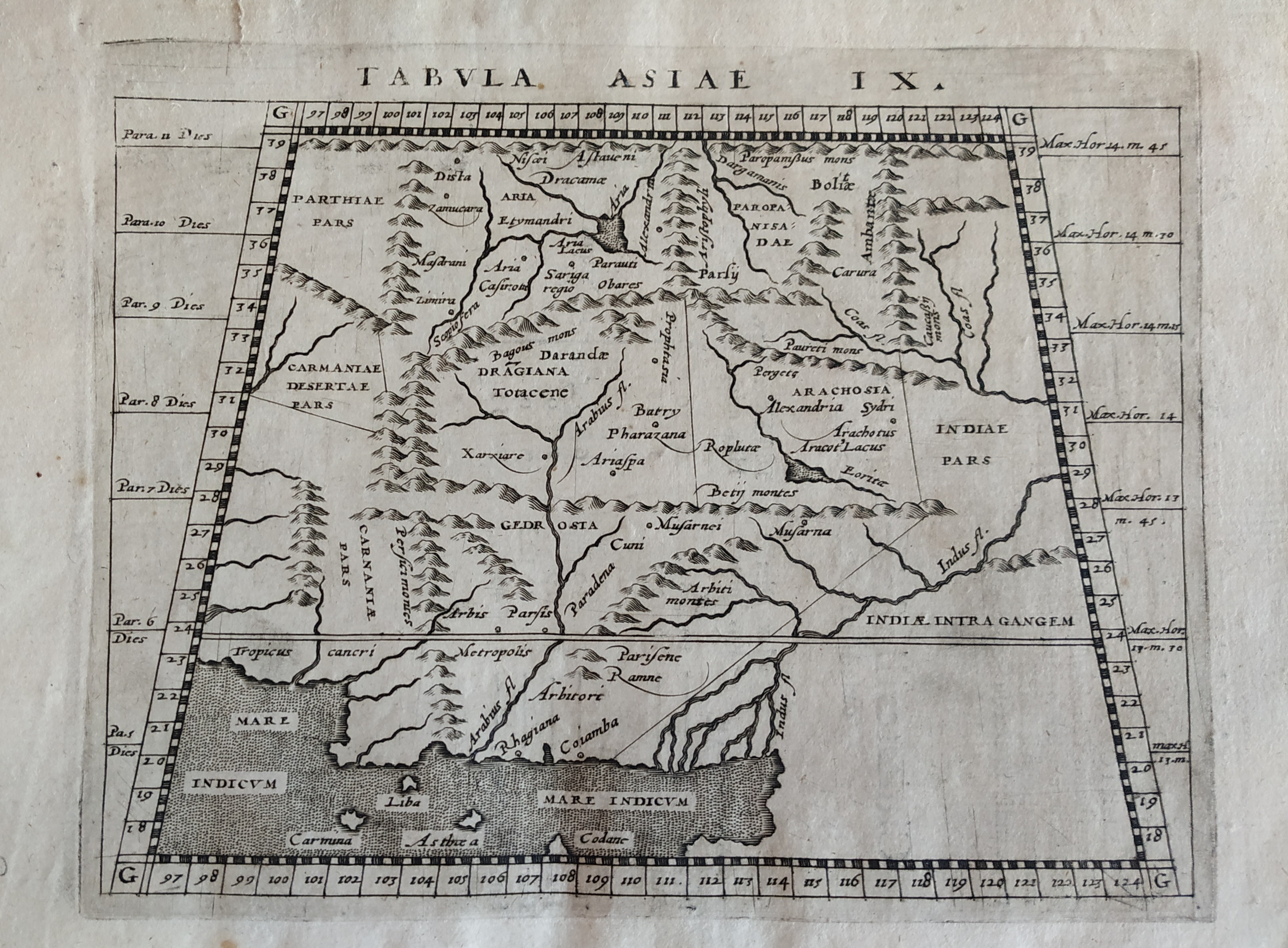
Map title
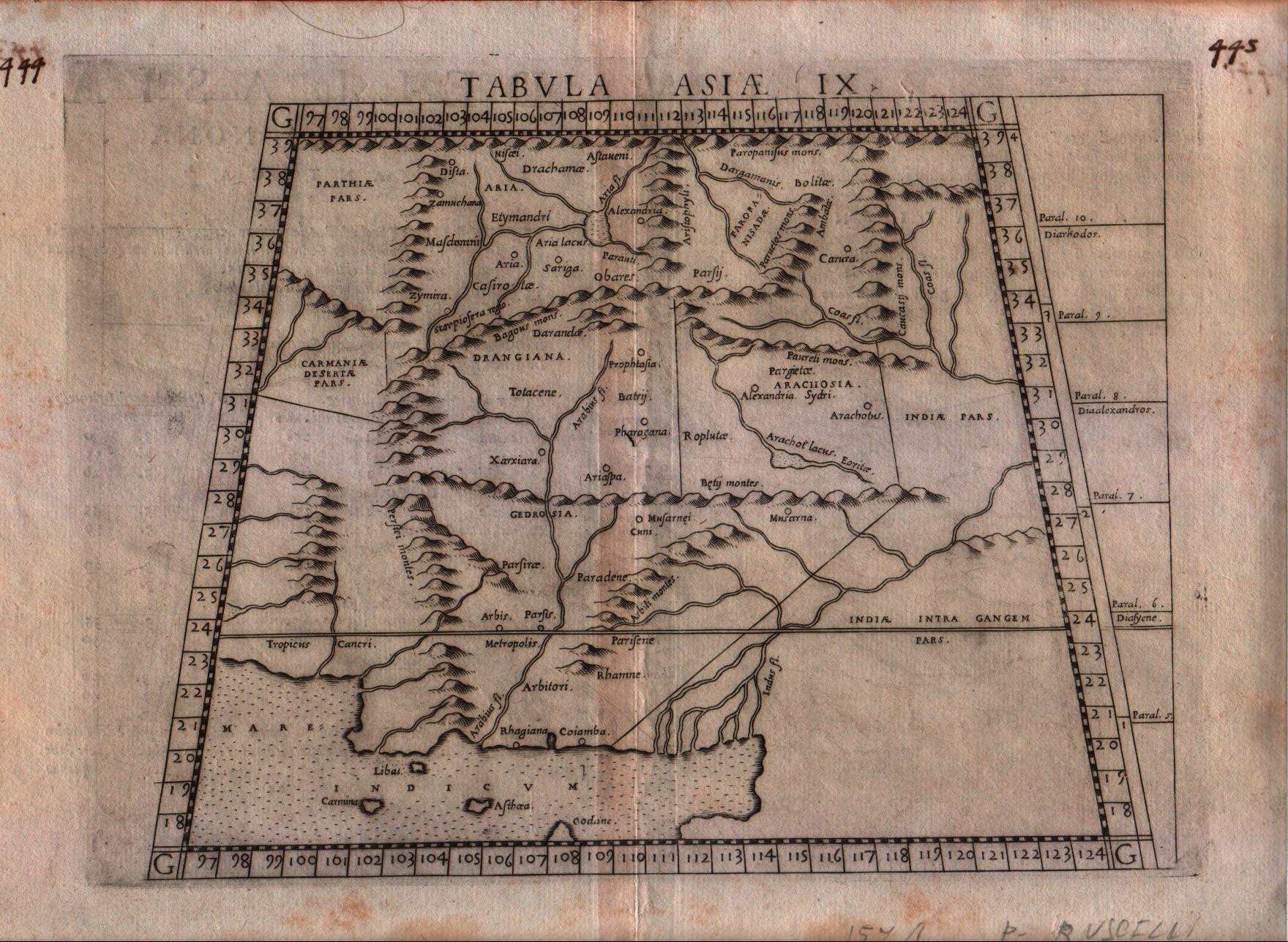
Tabula Asiae IX
Author
Munster
Location shown in map
Pakistan
Edition date
1542
Edition place
Basel
Editor
Henrich Petri
Atlas
Geographia
Price
250 Euro
State
[mint/excellent/VERY GOOD/good/fair/mediocre/poor]
Color
Black/white
Verso
Latin text pag.21
Size
Plate: cm (33 x 25.4) inches (12.99 x 10) Paper: cm (38.1 x 30.5) inches (15 x 12.01)
Technique
Woodcut
Note
Ptolemaic map of the region between the Caspian Sea and the Persian Gulf. Numerous ancient cities including Babylon.
Reference
--
Wiki
Here for more info
In stock
Available
Info
info@thetreasuremaps.com
Code
#0176
×
![Tabula Asiae IX by Munster, Pakistan, 1542]()
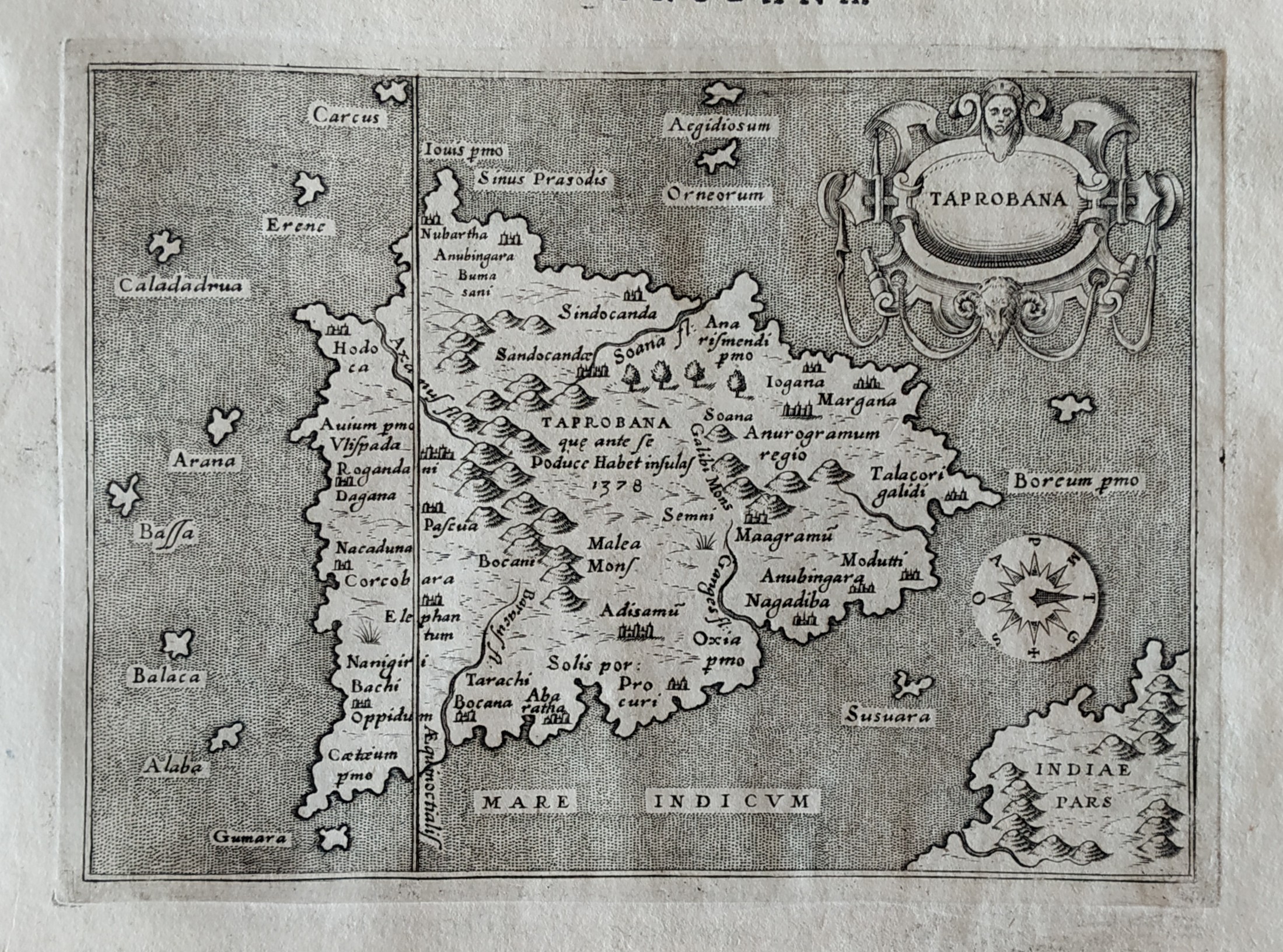
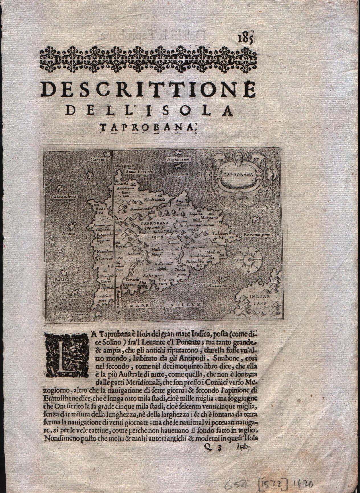
Map title
Taprobana
Author
Bordone
Location shown in map
Ceylon
Edition date
1547
Edition place
Venice
Editor
Federico Torresano
Atlas
Isolario
Price
500 Euro
State
[mint/EXCELLENT/very good/good/fair/mediocre/poor]
Color
Black/white
Verso
Italian text pag.72
Size
Plate: cm (15.2 x 20.3) inches (5.98 x 7.99) Paper: cm (21.6 x 30.5) inches (8.5 x 12.01)
Technique
Woodcut
Note
--
Reference
--
Wiki
Here for more info
In stock
Available
Info
info@thetreasuremaps.com
Code
#0170
×
![Taprobana by Bordone, Ceylon, 1547]()
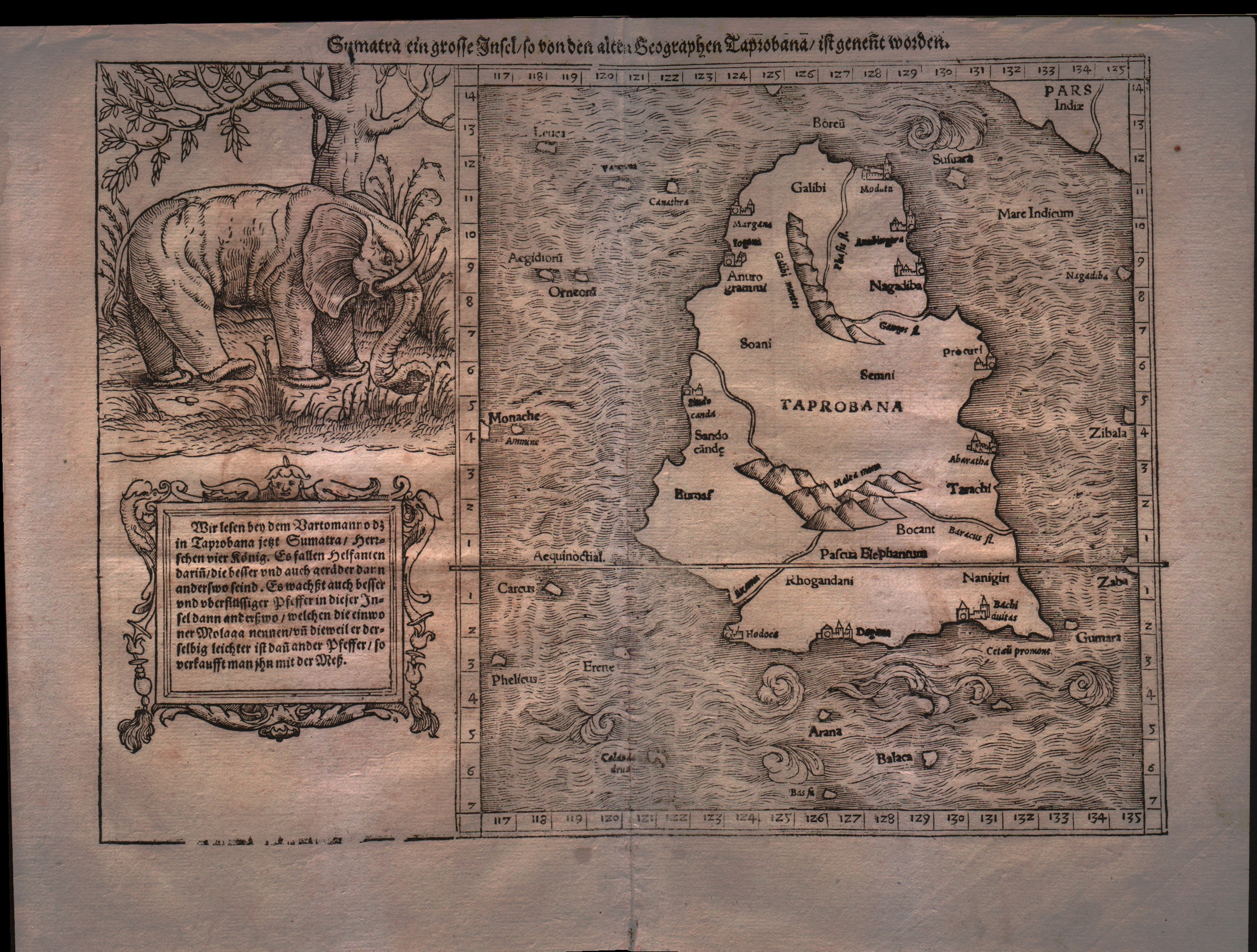
Map title
Sumatra ein grosse Inseln so von den alten Geographen Taprobana ist genent worden
Author
Munster
Location shown in map
Ceylon
Edition date
1555
Edition place
Basel
Editor
Henrich Petri
Atlas
Cosmographia Universalis
Price
500 Euro
State
[mint/EXCELLENT/very good/good/fair/mediocre/poor]
Color
Black/white
Verso
German text
Size
Plate: cm (33 x 24.1) inches (12.99 x 9.49) Paper: cm (30.5 x 40.6) inches (12.01 x 15.98)
Technique
Woodcut
Note
With large elephant vignette. Tabulae Asiae XII.
Reference
--
Wiki
Here for more info
In stock
Available
Info
info@thetreasuremaps.com
Code
#0177
×
![Sumatra ein grosse Inseln so von den alten Geographen Taprobana ist genent worden by Munster, Ceylon, 1555]()
Map title
Tabula Asiae XII
Author
Ruscelli
Location shown in map
Ceylon
Edition date
1561
Edition place
Venice
Editor
Vincenzo Valgrisi
Atlas
La Geographia di Claudio Tolomeo
Price
250 Euro
State
[mint/EXCELLENT/very good/good/fair/mediocre/poor]
Color
Black/white
Verso
Italian text pag.27
Size
Plate: cm (26 x 19) inches (10.24 x 7.48) Paper: cm (27.9 x 20.3) inches (10.98 x 7.99)
Technique
Copper engraving
Note
No particular notes for this maps.
Reference
--
Wiki
Here for more info
In stock
Available
Info
info@thetreasuremaps.com
Code
#0537
×
![Tabula Asiae XII by Ruscelli, Ceylon, 1561]()
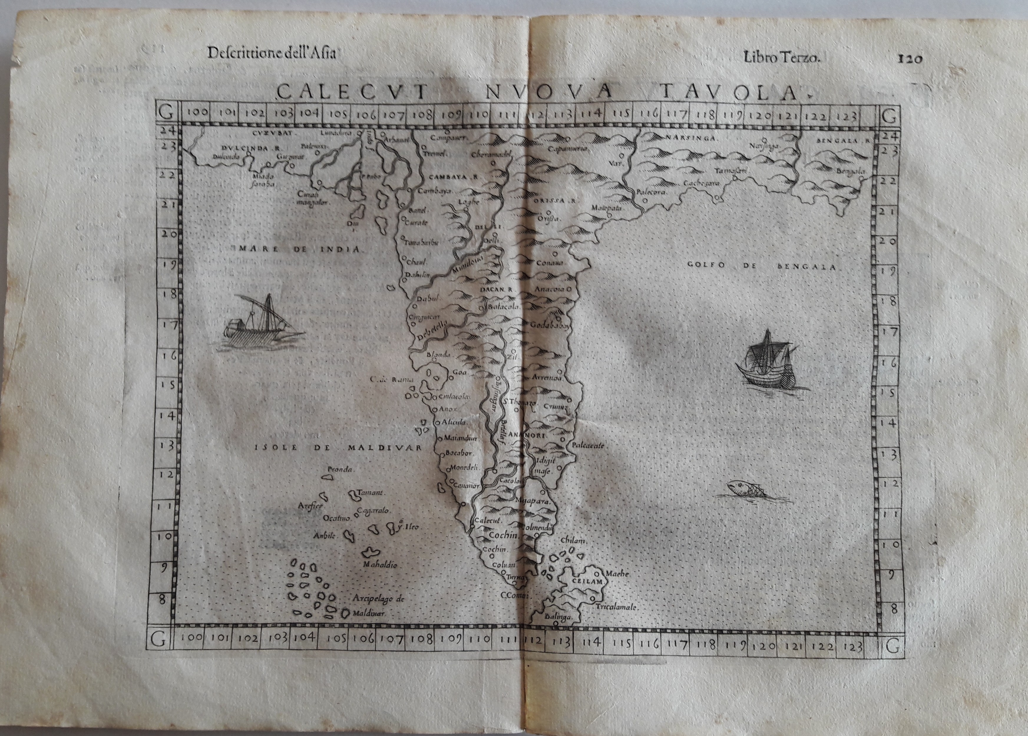
Map title
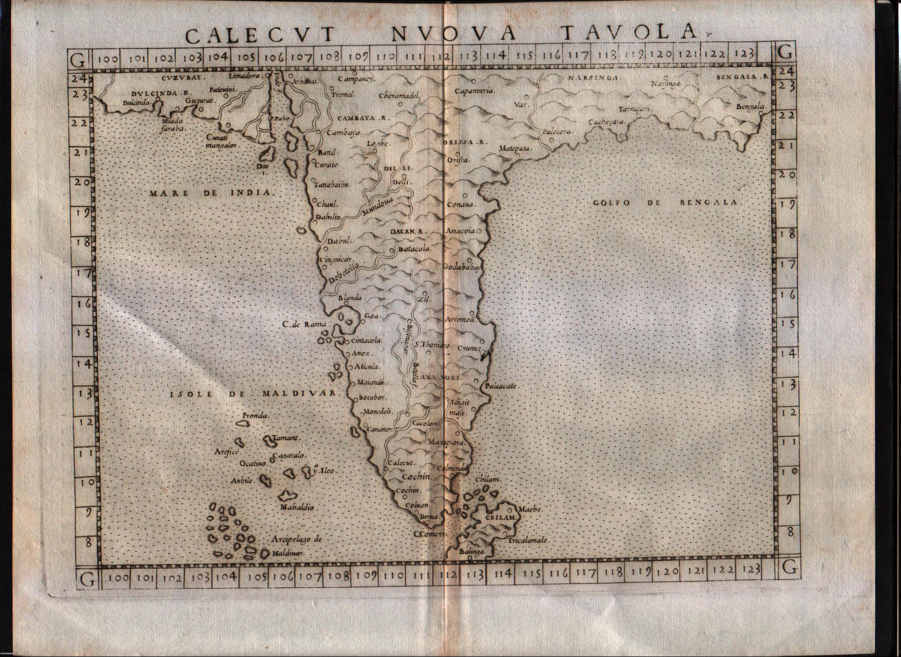
Calecut Nuova Tavola
Author
Ruscelli
Location shown in map
India
Edition date
1564
Edition place
Venice
Editor
Girolamo Ziletti
Atlas
La Geographia di Claudio Tolomeo
Price
500 Euro
State
[MINT/excellent/very good/good/fair/mediocre/poor]
Color
Black/white
Verso
Latin text pag.55
Size
Plate: cm (25.4 x 19) inches (10 x 7.48) Paper: cm (30.5 x 22.9) inches (12.01 x 9.02)
Technique
Copper engraving
Note
India shown.
Reference
--
Wiki
Here for more info
In stock
Available
Info
info@thetreasuremaps.com
Code
#0186
×
![Calecut Nuova Tavola by Ruscelli, India, 1564]()
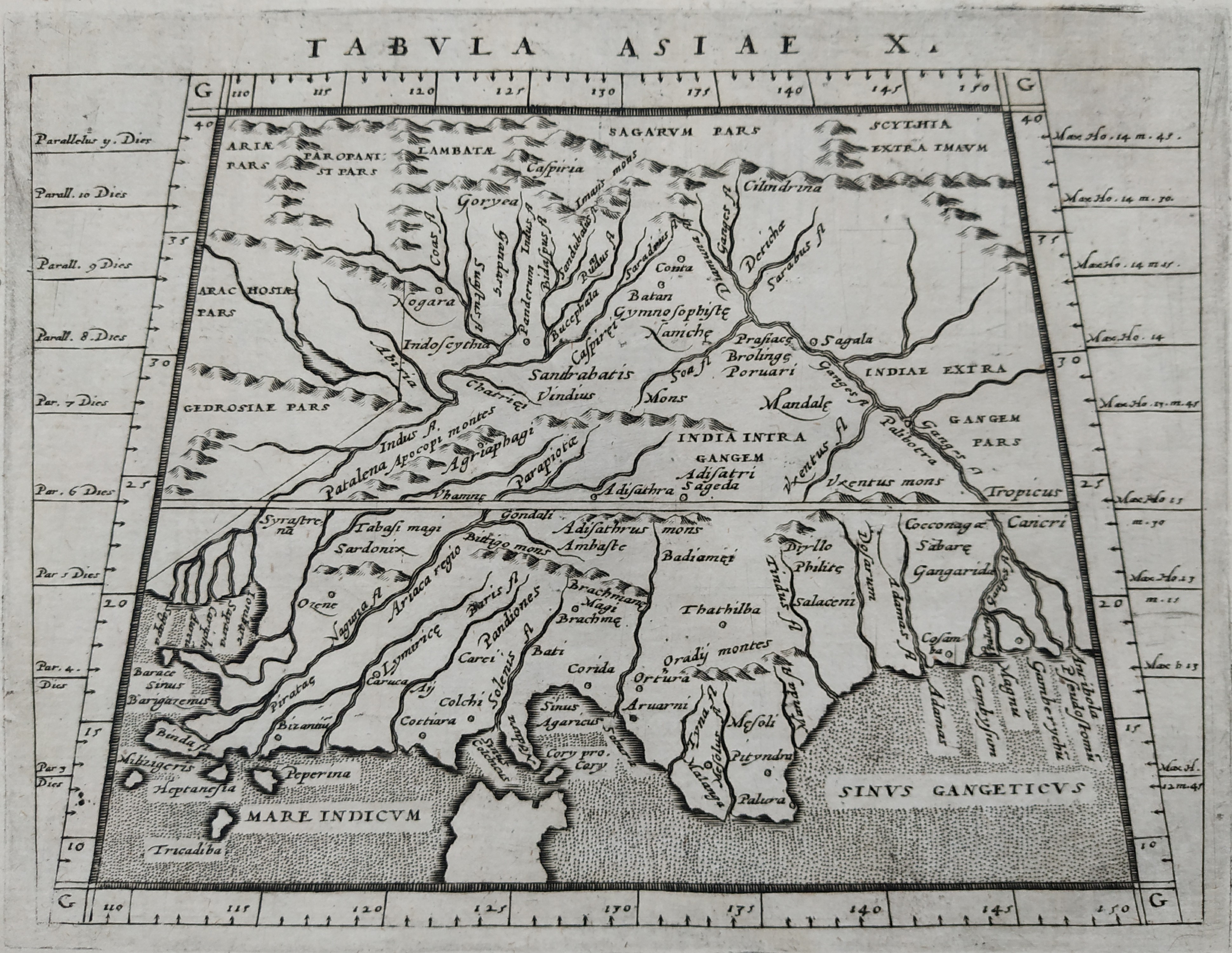
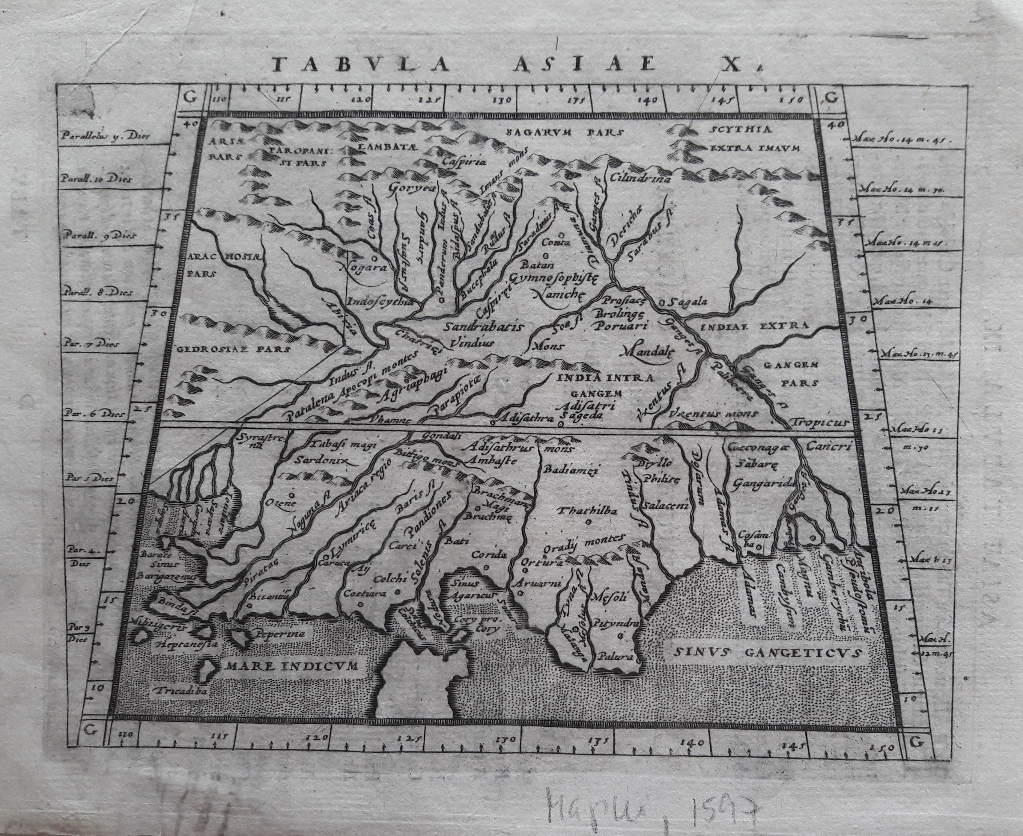
Map title
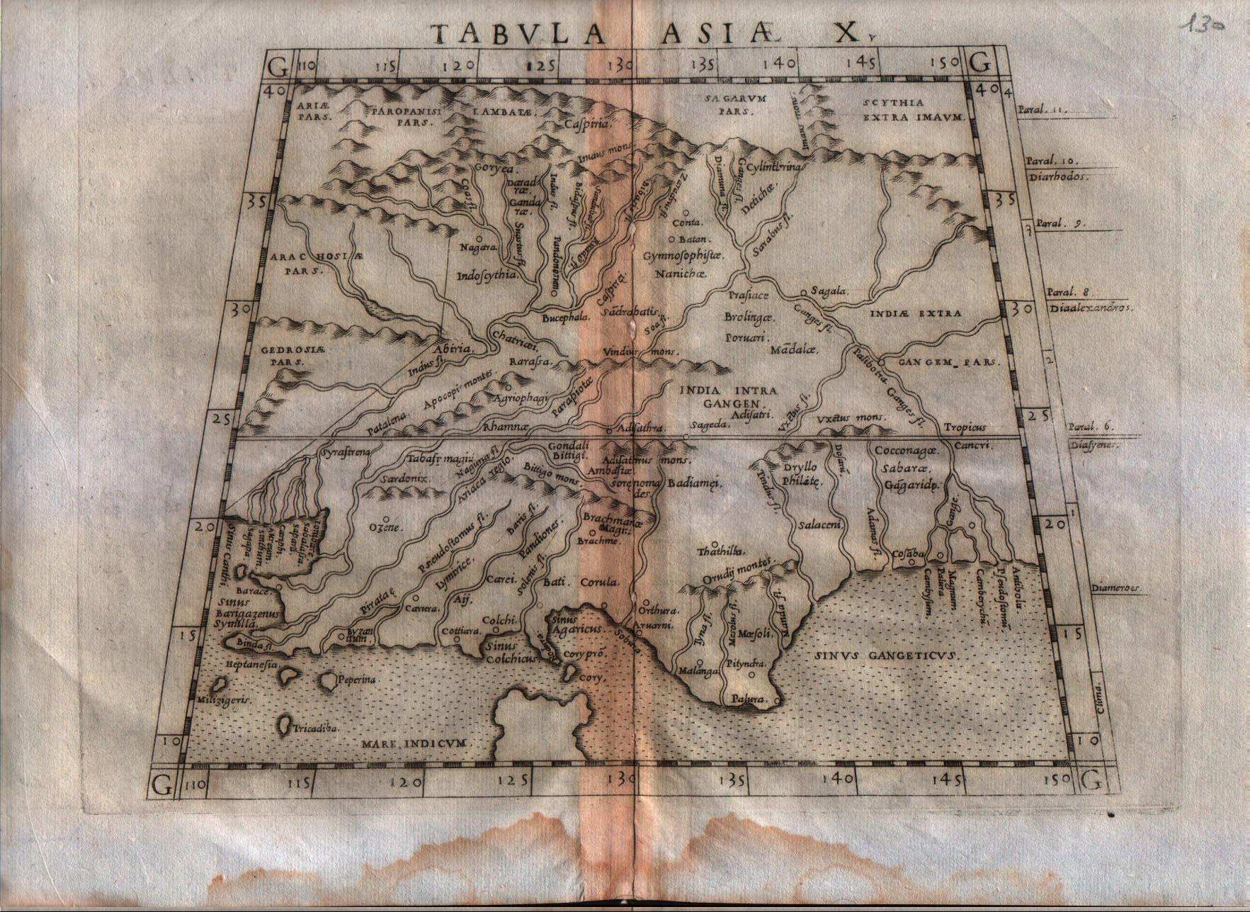
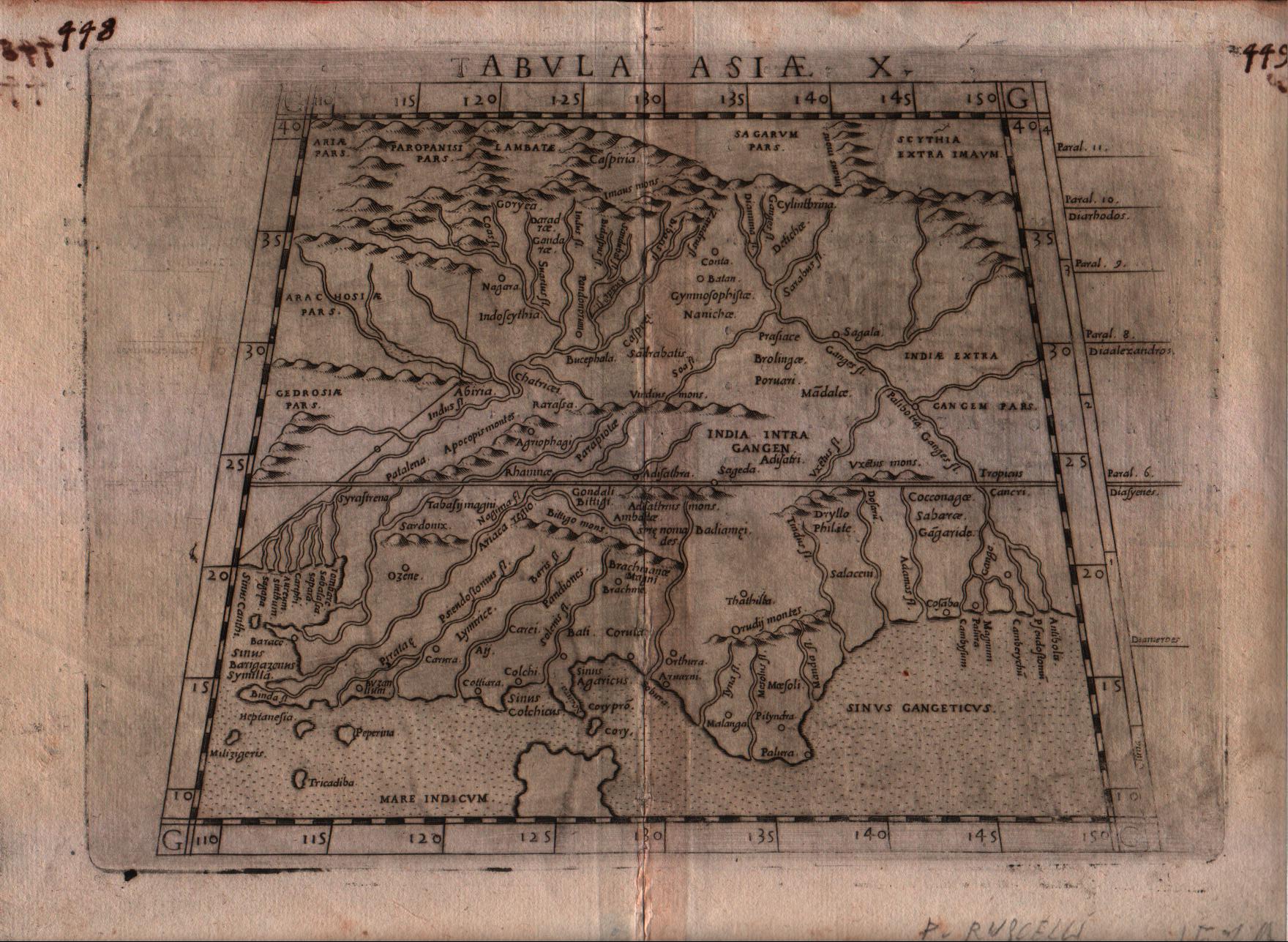
Tabula Asiae X
Author
Ruscelli
Location shown in map
India
Edition date
1564
Edition place
Venice
Editor
Girolamo Ziletti
Atlas
La Geographia di Claudio Tolomeo
Price
200 Euro
State
[mint/excellent/VERY GOOD/good/fair/mediocre/poor]
Color
Black/white
Verso
Latin text pag.54
Size
Plate: cm (25.4 x 19) inches (10 x 7.48) Paper: cm (30.5 x 22.9) inches (12.01 x 9.02)
Technique
Copper engraving
Note
India shown.
Reference
--
Wiki
Here for more info
In stock
Available
Info
info@thetreasuremaps.com
Code
#0181
×
![Tabula Asiae X by Ruscelli, India, 1564]()
Map title
Tabula Asiae IX
Author
Ruscelli
Location shown in map
Pakistan
Edition date
1574
Edition place
Venice
Editor
Giordano Ziletti
Atlas
La Geographia di Claudio Tolomeo
Price
125 Euro
State
[mint/EXCELLENT/very good/good/fair/mediocre/poor]
Color
Black/white
Verso
Italian text pag.24
Size
Plate: cm (25.4 x 19) inches (10 x 7.48) Paper: cm (30.5 x 22.9) inches (12.01 x 9.02)
Technique
Copper engraving
Note
Pakistan shown.
Reference
Genoa pubblic library "Civica Berio"
Wiki
Here for more info
In stock
Available
Info
info@thetreasuremaps.com
Code
#0189
×
![Tabula Asiae IX by Ruscelli, Pakistan, 1574]()
Map title
Tabula Asiae X
Author
Ruscelli
Location shown in map
India
Edition date
1574
Edition place
Venice
Editor
Giordano Ziletti
Atlas
La Geographia di Claudio Tolomeo
Price
200 Euro
State
[mint/EXCELLENT/very good/good/fair/mediocre/poor]
Color
Black/white
Verso
Italian text pag.25
Size
Plate: cm (25.4 x 19) inches (10 x 7.48) Paper: cm (30.5 x 22.9) inches (12.01 x 9.02)
Technique
Copper engraving
Note
India shown.
Reference
Genoa pubblic library "Civica Berio"
Wiki
Here for more info
In stock
Available
Info
info@thetreasuremaps.com
Code
#0190
×
![Tabula Asiae X by Ruscelli, India, 1574]()

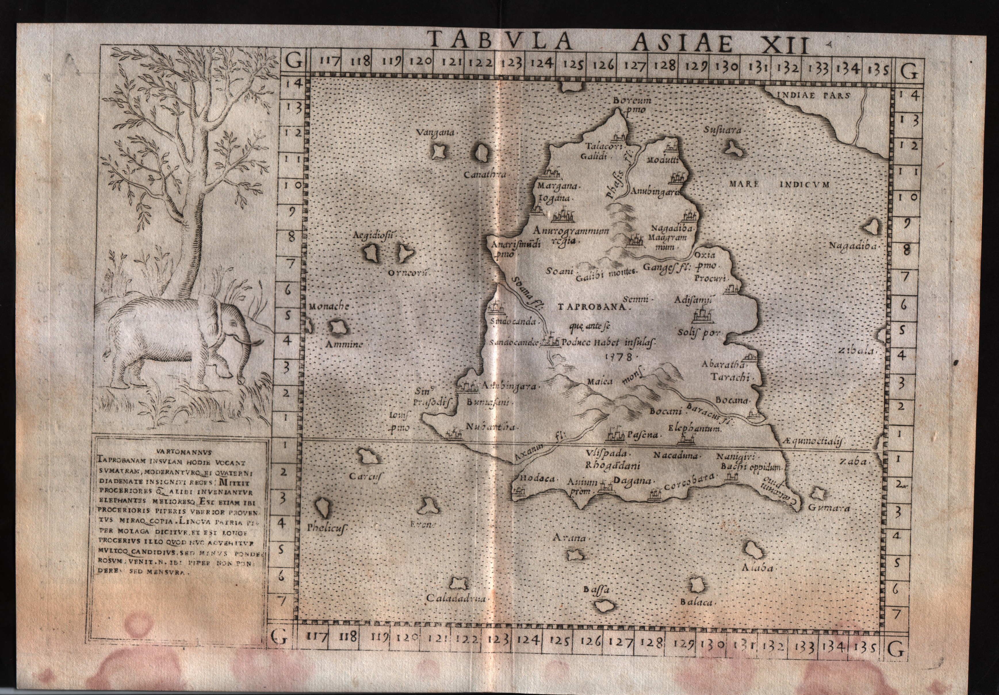
Map title
Tabula Asiae XII
Author
Ruscelli
Location shown in map
Ceylon
Edition date
1574
Edition place
Venice
Editor
Giordano Ziletti
Atlas
La Geographia di Claudio Tolomeo
Price
250 Euro
State
[mint/excellent/very good/good/FAIR/mediocre/poor]
Color
Black/white
Verso
Italian text pag.27
Size
Plate: cm (25.4 x 19) inches (10 x 7.48) Paper: cm (30.5 x 22.9) inches (12.01 x 9.02)
Technique
Copper engraving
Note
No particular notes for this maps
Reference
Genoa pubblic library "Civica Berio"
Wiki
Here for more info
In stock
Available
Info
info@thetreasuremaps.com
Code
#0195
×
![Tabula Asiae XII by Ruscelli, Ceylon, 1574]()
Map title
Descrittione dell'isola di Taprobana
Author
Porcacchi
Location shown in map
Sry Lanka
Edition date
1576
Edition place
Venice
Editor
--
Atlas
L'Isole piu famose del mondo -- S. Galignani and G. Porro
Price
Please ask: info@thetreasuremaps.com
State
[MINT/excellent/very good/good/fair/mediocre/poor]
Color
Black/white
Verso
Italian text pag.186
Size
Plate: cm (15.2 x 11.4) inches (5.98 x 4.49) Paper: cm (19 x 27.9) inches (7.48 x 10.98)
Technique
Copper engraving
Note
No particular notes for this maps
Reference
Genoa pubblic library "Civica Berio"
Wiki
Here for more info
In stock
Available
Info
info@thetreasuremaps.com
Code
#0797
×
![Descrittione dell'isola di Taprobana by Porcacchi, Sry Lanka, 1576]()
Map title
Tabula Asiae IX
Author
Magini
Location shown in map
Pakistan and Afganistan
Edition date
1596
Edition place
Venice
Editor
Heredes Simoni Galignani
Atlas
Geografia di Claudio Tolomeo -- Giovanni Antonio Magini
Price
Euro
State
[MINT/excellent/very good/good/fair/mediocre/poor]
Color
Black/white
Verso
Latin text pag.24
Size
Plate: cm (17.8 x 12.7) inches (7.01 x 5) Paper: cm (22.9 x 16.5) inches (9.02 x 6.5)
Technique
Copper engraving
Note
No particular notes for this maps.
Reference
--
Wiki
Here for more info
In stock
Available
Info
info@thetreasuremaps.com
Code
#0201
×
![Tabula Asiae IX by Magini, Pakistan and Afganistan, 1596]()
Map title
Tabula Asiae IX
Author
Magini
Location shown in map
Pakistan
Edition date
1597
Edition place
Cologne
Editor
Petrus Keschedt
Atlas
Geografia di Claudio Tolomeo -- Giovanni Antonio Magini
Price
Please ask: info@thetreasuremaps.com
State
[mint/EXCELLENT/very good/good/fair/mediocre/poor]
Color
Black/white
Verso
Latin text pag 24
Size
Plate: cm (17.8 x 15) inches (7.01 x 5.91) Paper: cm (22.9 x 16.5) inches (9.02 x 6.5)
Technique
Copper engraving
Note
Maps pirated from those of Girolamo Poro in Magini's edition.
Reference
--
Wiki
Here for more info
In stock
Available
Info
info@thetreasuremaps.com
Code
#0718
×
![Tabula Asiae IX by Magini, Pakistan, 1597]()
Map title
Tabula Asiae X
Author
Magini
Location shown in map
Indie
Edition date
1597
Edition place
Cologne
Editor
Petrus Keschedt
Atlas
Geografia di Claudio Tolomeo -- Giovanni Antonio Magini
Price
Please ask: info@thetreasuremaps.com
State
[mint/EXCELLENT/very good/good/fair/mediocre/poor]
Color
Black/white
Verso
Latin text pag 25
Size
Plate: cm (18 x 13.5) inches (7.09 x 5.31) Paper: cm (23 x 17) inches (9.06 x 6.69)
Technique
Copper engraving
Note
Maps pirated from those of Girolamo Poro in Magini's edition.
Reference
--
Wiki
Here for more info
In stock
Available
Info
info@thetreasuremaps.com
Code
#0832
×
![Tabula Asiae X by Magini, Indie, 1597]()
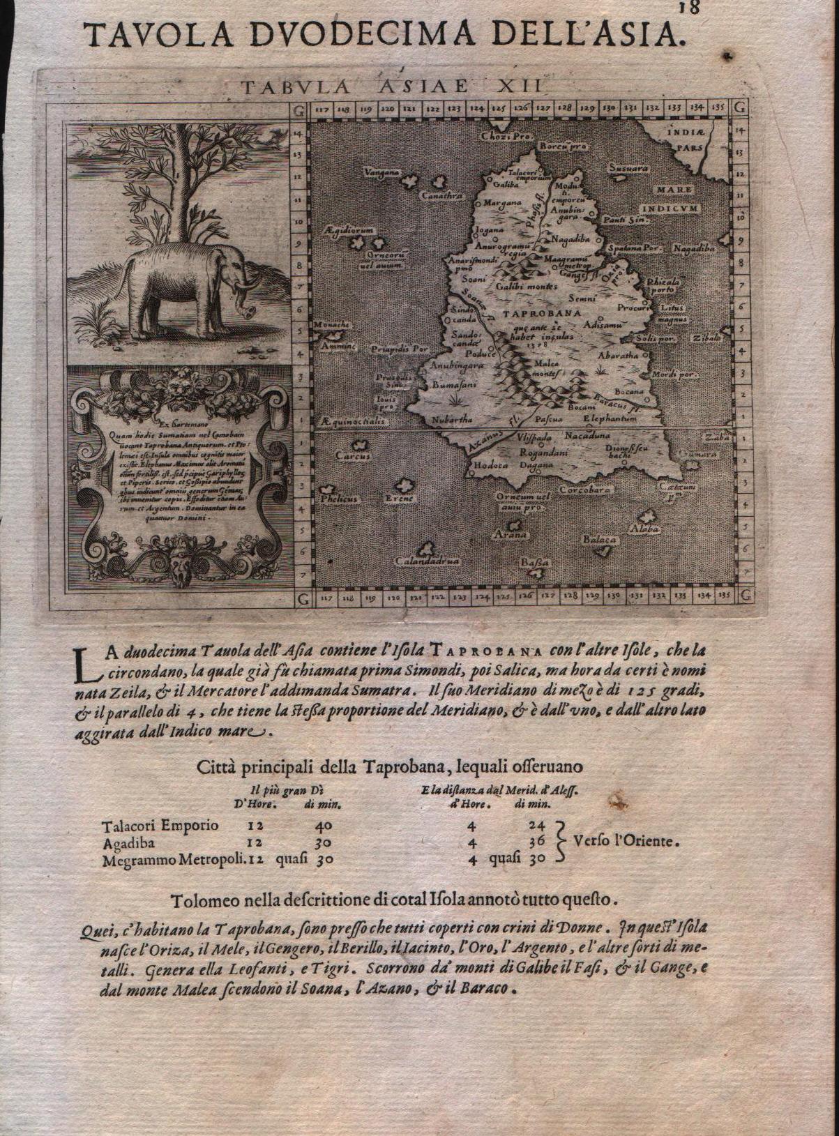
Map title
Tavola duodecima dell'Asia
Author
Magini
Location shown in map
Ceylon
Edition date
1598
Edition place
Venice
Editor
Battista & Giorgio Galignani
Atlas
Geografia di Claudio Tolomeo -- Giovanni Antonio Magini
Price
250 Euro
State
[MINT/excellent/very good/good/fair/mediocre/poor]
Color
Black/white
Verso
Italian text
Size
Plate: cm (12.7 x 17.8) inches (5 x 7.01) Paper: cm (20.3 x 30.5) inches (7.99 x 12.01)
Technique
Copper engraving
Note
With large elephant vignette. Tabulae Asiae XII.
Reference
--
Wiki
Here for more info
In stock
Available
Info
info@thetreasuremaps.com
Code
#0209
×
![Tavola duodecima dell'Asia by Magini, Ceylon, 1598]()
Map title
Calecut nuova tavola
Author
Ruscelli
Location shown in map
India
Edition date
1599
Edition place
Venice
Editor
Rosaccio
Atlas
La Geographia di Claudio Tolomeo
Price
500 Euro
State
[mint/excellent/VERY GOOD/good/fair/mediocre/poor]
Color
Black/white
Verso
Italian text pag.119
Size
Plate: cm (25 x 18) inches (9.84 x 7.09) Paper: cm (34 x 23) inches (13.39 x 9.06)
Technique
Copper engraving
Note
No particular notes for this maps.
Reference
--
Wiki
Here for more info
In stock
Available
Info
info@thetreasuremaps.com
Code
#0639
×
![Calecut nuova tavola by Ruscelli, India, 1599]()
Map title
Tabula Asiae X
Author
Magini
Location shown in map
Indie
Edition date
1617
Edition place
Arnheim
Editor
Ioannes Ianssonius
Atlas
Geografia di Claudio Tolomeo -- Giovanni Antonio Magini
Price
Please ask: info@thetreasuremaps.com
State
[mint/EXCELLENT/very good/good/fair/mediocre/poor]
Color
Black/white
Verso
Latin text pag 25
Size
Plate: cm (17.8 x 12.7) inches (7.01 x 5) Paper: cm (21.6 x 17.8) inches (8.5 x 7.01)
Technique
Copper engraving
Note
No particular notes for this maps.
Reference
--
Wiki
Here for more info
In stock
Available
Info
info@thetreasuremaps.com
Code
#0643
×
![Tabula Asiae X by Magini, Indie, 1617]()
Map title
Descrittione dell'isole Taprobana
Author
Porcacchi
Location shown in map
Ceylon
Edition date
1620
Edition place
Venice
Editor
--
Atlas
L'Isole piu famose del mondo -- Pietr'Antonio Brigonci
Price
200 Euro
State
[MINT/excellent/very good/good/fair/mediocre/poor]
Color
Black/white
Verso
Italian text pag.186
Size
Plate: cm (14 x 11.4) inches (5.51 x 4.49) Paper: cm (20.3 x 30.5) inches (7.99 x 12.01)
Technique
Copper engraving
Note
No particular notes for this maps
Reference
--
Wiki
Here for more info
In stock
Available
Info
info@thetreasuremaps.com
Code
#0197
×
![Descrittione dell'isole Taprobana by Porcacchi, Ceylon, 1620]()
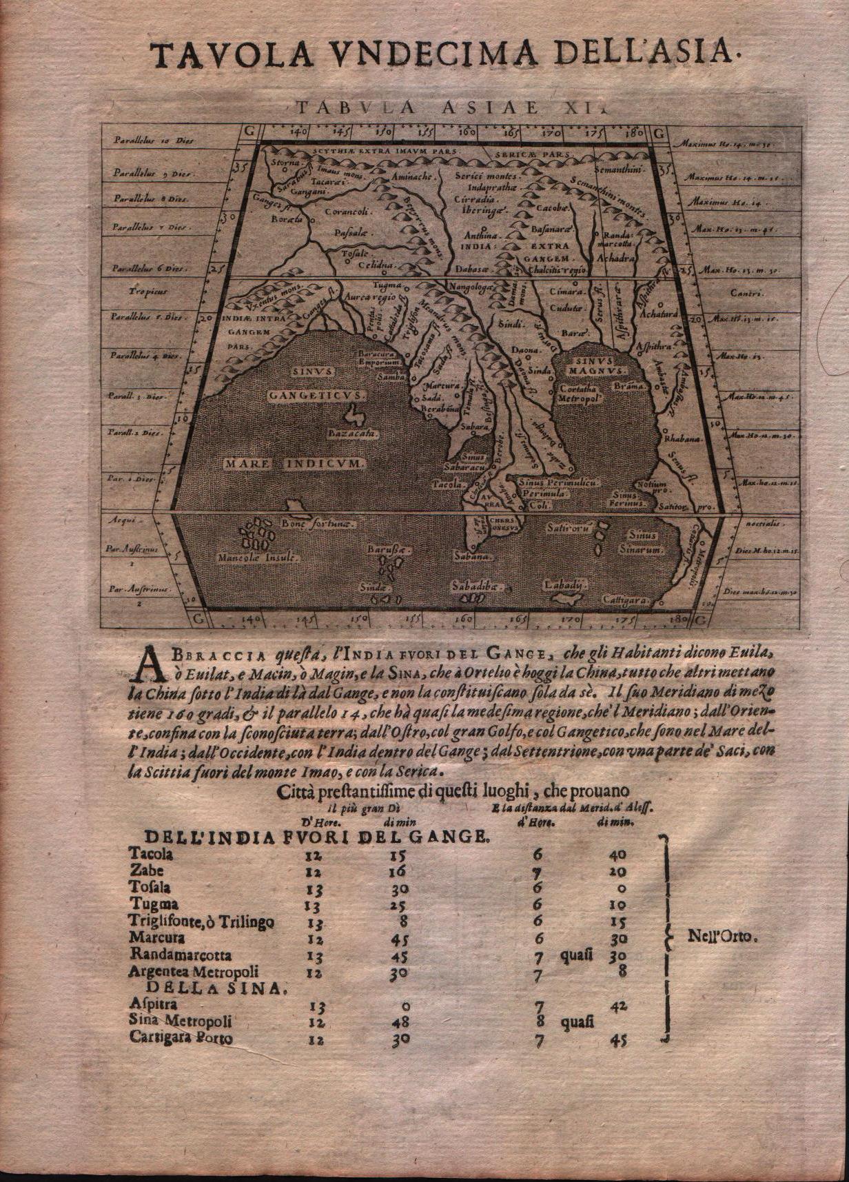
Map title
Tabula Asiae XI
Author
Magini
Location shown in map
India
Edition date
1621
Edition place
Padova
Editor
Paolo and Francesco Galignani
Atlas
Geografia di Claudio Tolomeo -- Giovanni Antonio Magini
Price
Please ask: info@thetreasuremaps.com
State
[MINT/excellent/very good/good/fair/mediocre/poor]
Color
Black/white
Verso
Italian text
Size
Plate: cm (12.7 x 17.8) inches (5 x 7.01) Paper: cm (20.3 x 30.5) inches (7.99 x 12.01)
Technique
Copper engraving
Note
--
Reference
--
Wiki
Here for more info
In stock
Available
Info
info@thetreasuremaps.com
Code
#0562
×
![Tabula Asiae XI by Magini, India, 1621]()
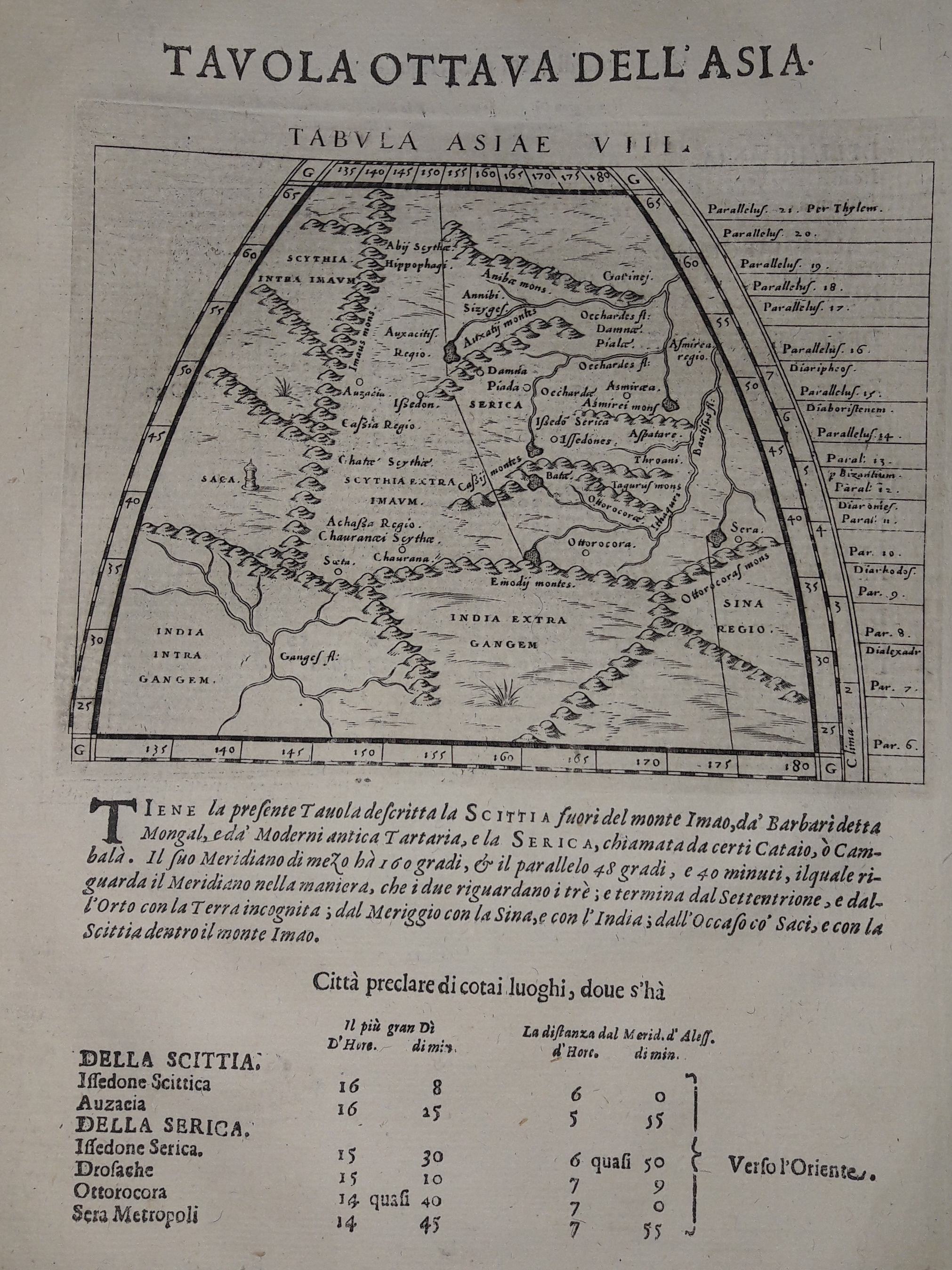
Map title
Tabula Asiae VIII
Author
Magini
Location shown in map
India
Edition date
1621
Edition place
Padova
Editor
Paolo and Francesco Galignani
Atlas
Geografia di Claudio Tolomeo -- Giovanni Antonio Magini
Price
125 Euro
State
[MINT/excellent/very good/good/fair/mediocre/poor]
Color
Black/white
Verso
Italian text pag 15
Size
Plate: cm (12.7 x 17.8) inches (5 x 7.01) Paper: cm (20.3 x 30.5) inches (7.99 x 12.01)
Technique
Copper engraving
Note
--
Reference
--
Wiki
Here for more info
In stock
Available
Info
info@thetreasuremaps.com
Code
#0631
×
![Tabula Asiae VIII by Magini, India, 1621]()
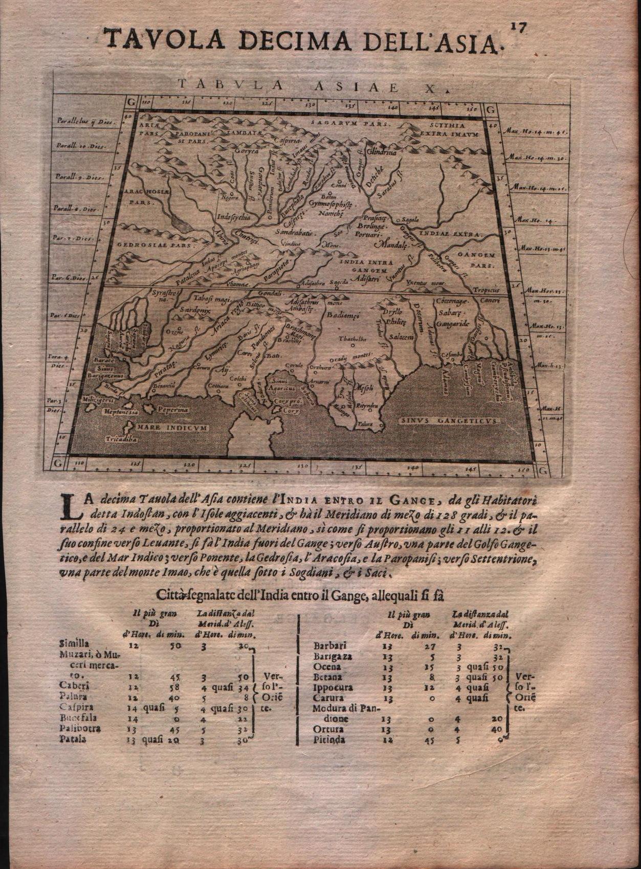
Map title
Tabula Asiae X
Author
Magini
Location shown in map
India
Edition date
1621
Edition place
Padova
Editor
Paolo and Francesco Galignani
Atlas
Geografia di Claudio Tolomeo -- Giovanni Antonio Magini
Price
125 Euro
State
[MINT/excellent/very good/good/fair/mediocre/poor]
Color
Black/white
Verso
Italian text
Size
Plate: cm (12.7 x 17.8) inches (5 x 7.01) Paper: cm (20.3 x 30.5) inches (7.99 x 12.01)
Technique
Copper engraving
Note
--
Reference
--
Wiki
Here for more info
In stock
Available
Info
info@thetreasuremaps.com
Code
#0207
×
![Tabula Asiae X by Magini, India, 1621]()
Pages: 1 2