India-Ceylon
Pages: 1 2
Map title
Sinus Gangeticus Vulgo Golfo De Bengala Nova descriptio
Author
Jansson
Location shown in map
India
Edition date
Circa 1670
Edition place
Amsterdam
Editor
Schenk
Atlas
Novus Atlas
Price
450 Euro
State
[mint/EXCELLENT/very good/good/fair/mediocre/poor] repaired
Color
Old colors
Verso
Blank
Size
Plate: cm (54 x 50) inches (21.26 x 19.69) Paper: cm (54 x 49) inches (21.26 x 19.29)
Technique
Copper engraving
Note
Reference
Wiki
Here for more info
In stock
Available
Info
info@thetreasuremaps.com
Code
#1200
×
![Sinus Gangeticus Vulgo Golfo De Bengala Nova descriptio by Jansson, India, Circa 1670]()
Map title
Presquisle de l'Inde de ca le Gange
Author
DuVal
Location shown in map
India
Edition date
1682
Edition place
Paris
Editor
--
Atlas
La geographie universelle - P. Du Val d'Abbeville
Price
100 Euro
State
[mint/EXCELLENT/very good/good/fair/mediocre/poor]
Color
Black/white
Verso
Blank
Size
Plate: cm (12.7 x 10.2) inches (5 x 4.02) Paper: cm (16.5 x 16.5) inches (6.5 x 6.5)
Technique
Copper engraving
Note
No particular notes for this maps
Reference
--
Wiki
Here for more info
In stock
Available
Info
info@thetreasuremaps.com
Code
#0218
×
![Presquisle de l'Inde de ca le Gange by DuVal, India, 1682]()
Map title
Ceylan et les Maldives
Author
Sanson
Location shown in map
Ceylon
Edition date
Circa 1683
Edition place
Paris
Editor
Atlas
L'Europe en Plusieurs Cartes, et en divers Traittes de Geographie et d'Histoire.
Price
200 Euro
State
[mint/EXCELLENT/very good/good/fair/mediocre/poor]
Color
Old colors
Verso
Blank
Size
Plate: cm (24 x 19) inches (9.45 x 7.48) Paper: cm (32 x 22) inches (12.6 x 8.66)
Technique
Copper engraving
Note
Reference
Wiki
Here for more info
In stock
Available
Info
info@thetreasuremaps.com
Code
#1007
×
![Ceylan et les Maldives by Sanson, Ceylon, Circa 1683]()
Map title
Penisola dell'India di qua dal Gange
Author
Cantelli da Vignola
Location shown in map
India
Edition date
1689
Edition place
Rome
Editor
De Rossi
Atlas
Mercurio Geografico
Price
800 Euro
State
[mint/EXCELLENT/very good/good/fair/mediocre/poor]
Color
Old colors
Verso
Blank
Size
Plate: cm (59 x 45) inches (23.23 x 17.72) Paper: cm (53 x 43) inches (20.87 x 16.93)
Technique
Copper engraving
Note
Reference
Wiki
Here for more info
In stock
Sold
Info
info@thetreasuremaps.com
Code
#1327
×
![Penisola dell'India di qua dal Gange by Cantelli da Vignola, India, 1689]()
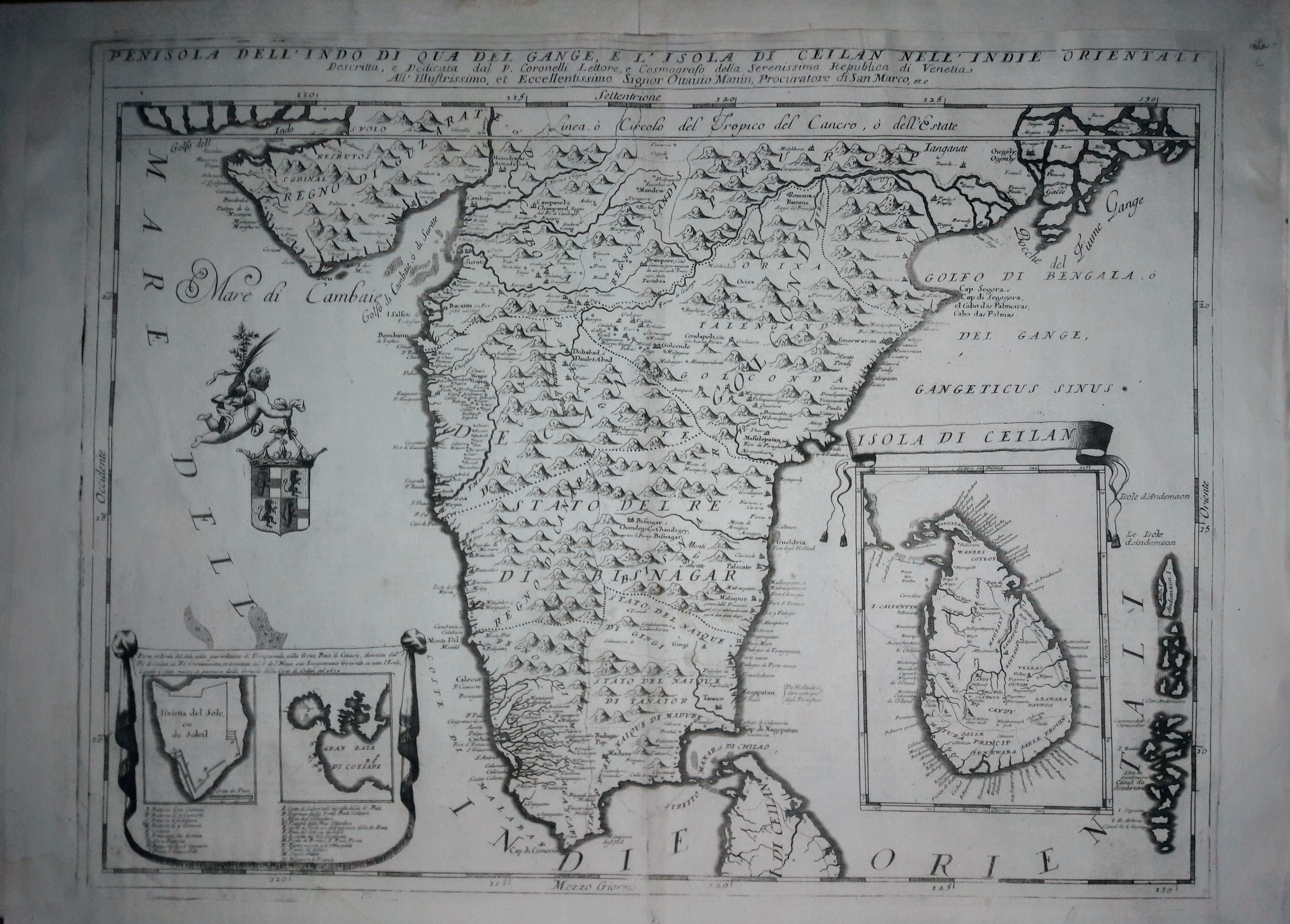
Map title
Penisola dell'Indo di qua del Gange e l'isola di Ceylan
Author
Coronelli
Location shown in map
Inde
Edition date
Circa 1690
Edition place
Venice
Editor
Atlas
Atlante veneto
Price
600 Euro
State
[mint/EXCELLENT/very good/good/fair/mediocre/poor]
Color
Black/white
Verso
Italian text pag.115
Size
Plate: cm (46 x 61) inches (18.11 x 24.02) Paper: cm (69 x 49) inches (27.17 x 19.29)
Technique
Copper engraving
Note
No particular notes for this maps.
Reference
--
Wiki
Here for more info
In stock
Available
Info
info@thetreasuremaps.com
Code
#0653
×
![Penisola dell'Indo di qua del Gange e l'isola di Ceylan by Coronelli, Inde, Circa 1690]()

Map title
Carte de la Perse
Author
Cellarius
Location shown in map
South west Asia
Edition date
1748
Edition place
--
Editor
--
Atlas
Geographia Antiqua
Price
Please ask: info@thetreasuremaps.com
State
[mint/EXCELLENT/very good/good/fair/mediocre/poor]
Color
Old outlined
Verso
Blank
Size
Plate: cm (34.3 x 25.4) inches (13.5 x 10) Paper: cm (39.4 x 26.7) inches (15.51 x 10.51)
Technique
Copper engraving
Note
Beautifull map of south Asia. Old India but new Caspian sea.
Reference
--
Wiki
Here for more info
In stock
Sold
Info
info@thetreasuremaps.com
Code
#0391
×
![Carte de la Perse by Cellarius, South west Asia, 1748]()
Map title
La Parthie et la Perse
Author
Cellarius
Location shown in map
South west Asia
Edition date
1748
Edition place
--
Editor
--
Atlas
Geographia Antiqua
Price
Please ask: info@thetreasuremaps.com
State
[mint/EXCELLENT/very good/good/fair/mediocre/poor]
Color
Old outlined
Verso
Blank
Size
Plate: cm (34.3 x 25.4) inches (13.5 x 10) Paper: cm (39.4 x 31.8) inches (15.51 x 12.52)
Technique
Copper engraving
Note
Beautifull map of south Asia. Old India but new Caspian sea.
Reference
--
Wiki
Here for more info
In stock
Sold
Info
info@thetreasuremaps.com
Code
#0433
×
![La Parthie et la Perse by Cellarius, South west Asia, 1748]()
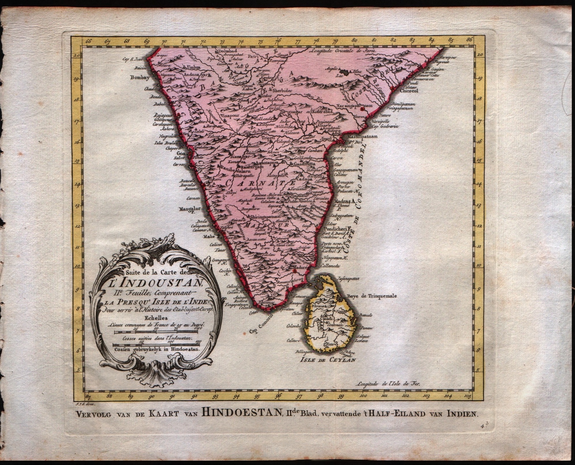
Map title
Suite de la carte de l'Indoustan, II feuille, comprendant la presqu'isle de l'Inde
Author
Bellin
Location shown in map
India
Edition date
1757
Edition place
Paris
Editor
--
Atlas
Historie General des Voyages -- Prevost
Price
125 Euro
State
[mint/EXCELLENT/very good/good/fair/mediocre/poor]
Color
Black/white
Verso
Blank
Size
Plate: cm (24.1 x 21.6) inches (9.49 x 8.5) Paper: cm (33 x 26.7) inches (12.99 x 10.51)
Technique
Copper engraving
Note
No particular notes for this maps
Reference
--
Wiki
Here for more info
In stock
Available
Info
info@thetreasuremaps.com
Code
#0547
×
![Suite de la carte de l'Indoustan, II feuille, comprendant la presqu'isle de l'Inde by Bellin, India, 1757]()
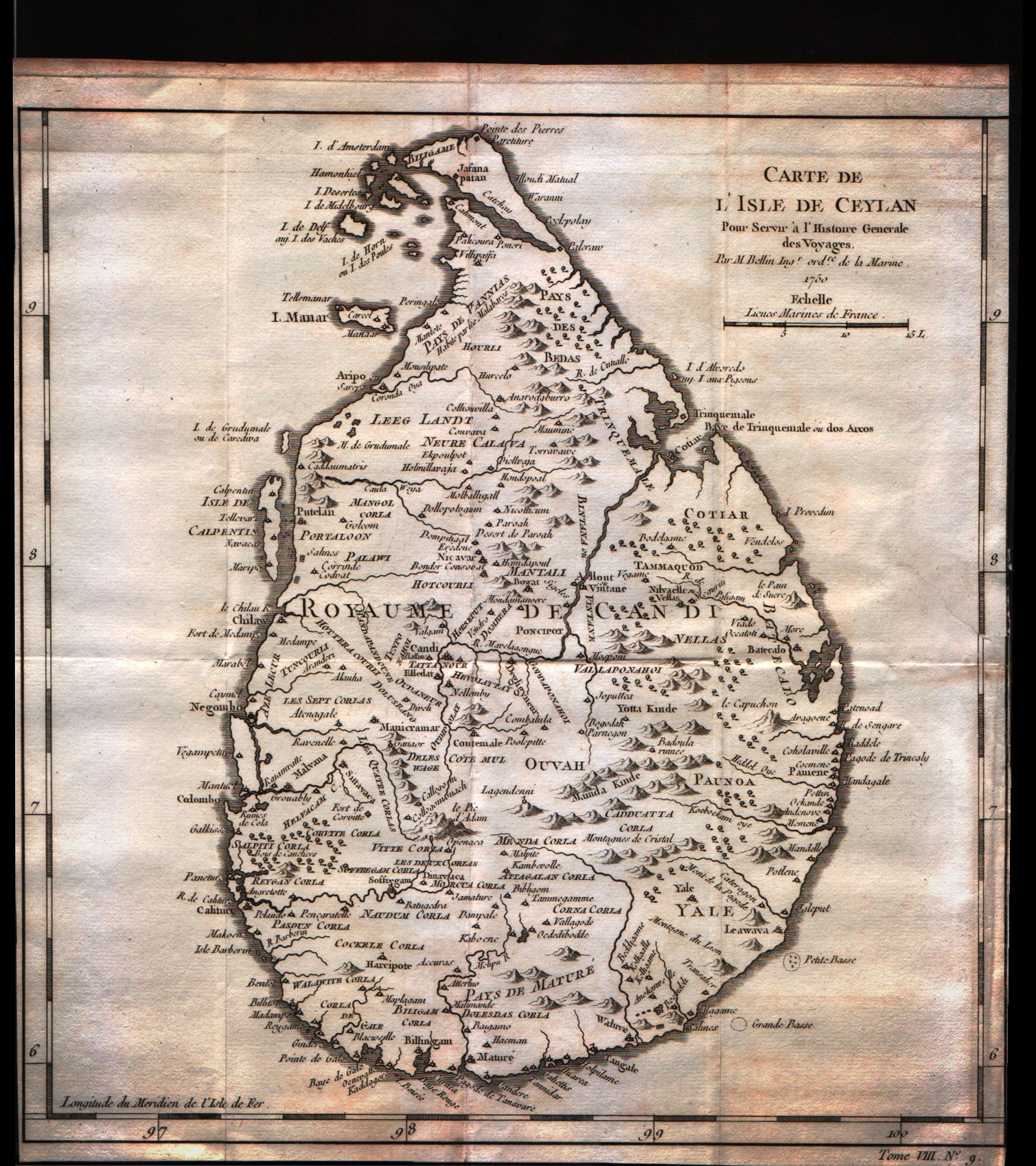
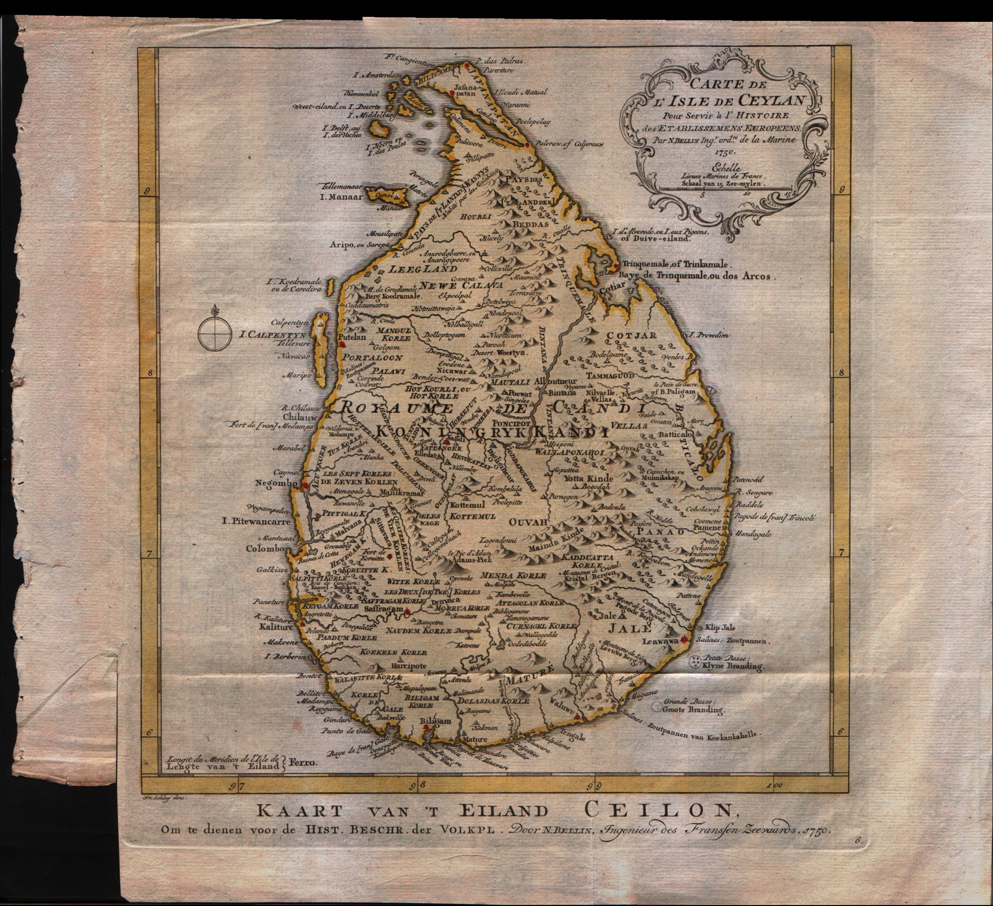
Map title
Carte de l'isle de Ceylan
Author
Bellin
Location shown in map
Ceylan islands
Edition date
1757
Edition place
Paris
Editor
--
Atlas
Historie General des Voyages -- Prevost
Price
125 Euro
State
[mint/excellent/very good/GOOD/fair/mediocre/poor]
Color
Black/white
Verso
Blank
Size
Plate: cm (24.1 x 25.4) inches (9.49 x 10) Paper: cm (24.1 x 26.7) inches (9.49 x 10.51)
Technique
Copper engraving
Note
No particular notes for this maps
Reference
--
Wiki
Here for more info
In stock
Sold
Info
info@thetreasuremaps.com
Code
#0253
×
![Carte de l'isle de Ceylan by Bellin, Ceylan islands, 1757]()
Map title
Carte de l'isle de Ceylan
Author
Bellin
Location shown in map
Ceylan islands
Edition date
1757
Edition place
Paris
Editor
--
Atlas
Historie General des Voyages -- Prevost
Price
125 Euro
State
[mint/excellent/very good/GOOD/fair/mediocre/poor]
Color
Black/white
Verso
Blank
Size
Plate: cm (24.1 x 25.4) inches (9.49 x 10) Paper: cm (24.1 x 25.4) inches (9.49 x 10)
Technique
Copper engraving
Note
No particular notes for this maps
Reference
--
Wiki
Here for more info
In stock
Available
Info
info@thetreasuremaps.com
Code
#0252
×
![Carte de l'isle de Ceylan by Bellin, Ceylan islands, 1757]()
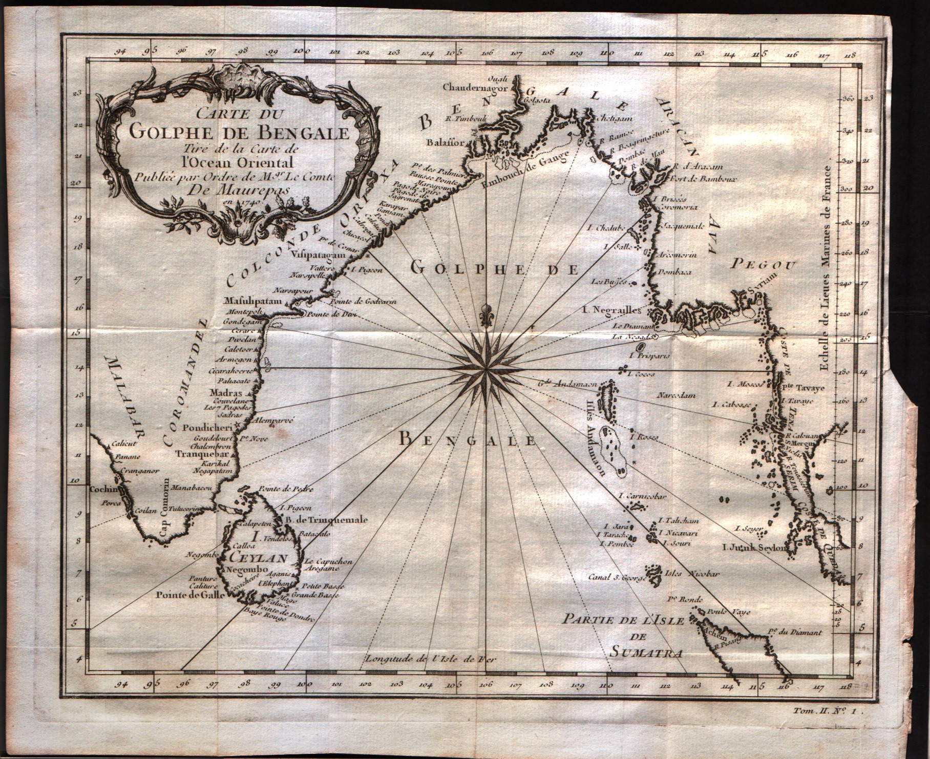
Map title
Carte du Golphe de Bengale
Author
Bellin
Location shown in map
--
Edition date
1757
Edition place
Paris
Editor
--
Atlas
Historie General des Voyages -- Prevost
Price
150 Euro
State
[mint/excellent/VERY GOOD/good/fair/mediocre/poor]
Color
Black/white
Verso
Blank
Size
Plate: cm (26.7 x 22.9) inches (10.51 x 9.02) Paper: cm (29.8 x 24.8) inches (11.73 x 9.76)
Technique
Copper engraving
Note
No particular notes for this maps
Reference
--
Wiki
Here for more info
In stock
Available
Info
info@thetreasuremaps.com
Code
#0242
×
![Carte du Golphe de Bengale by Bellin, --, 1757]()
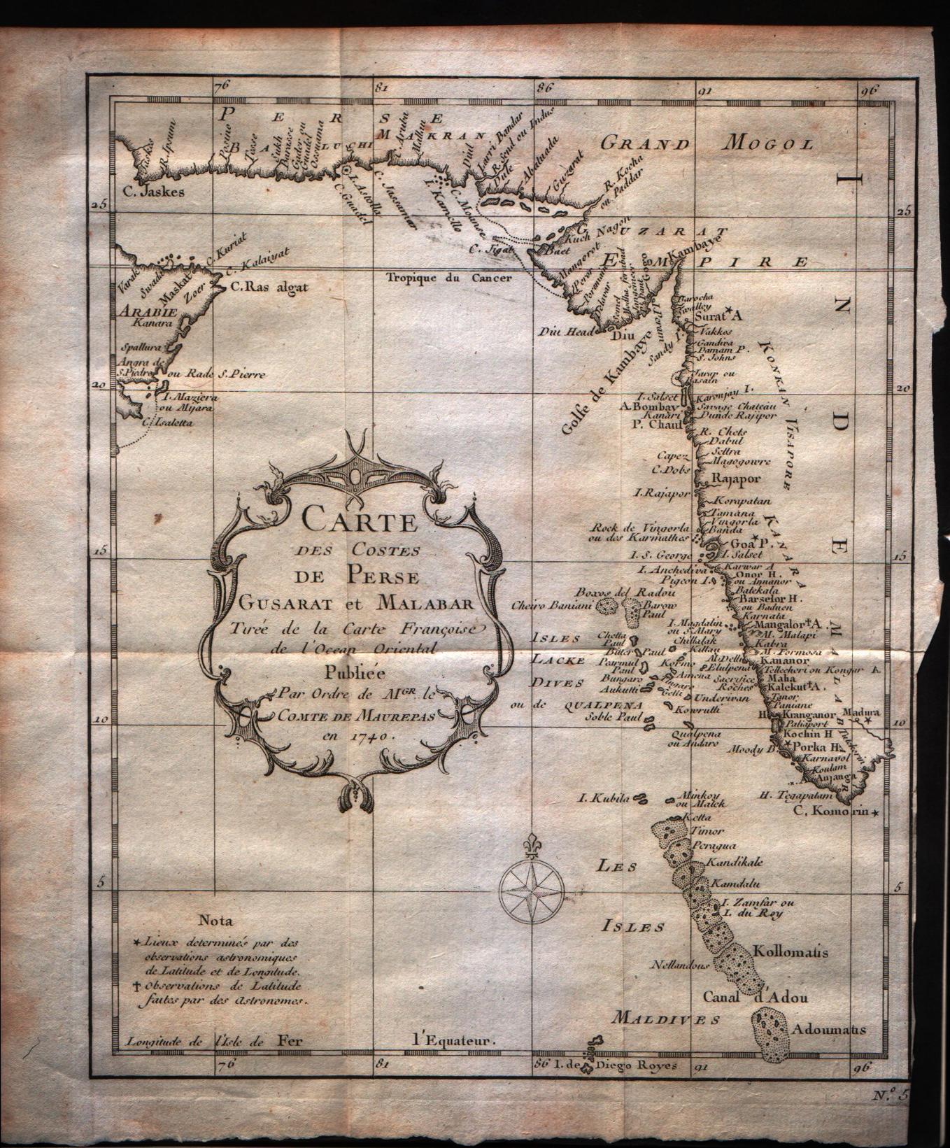
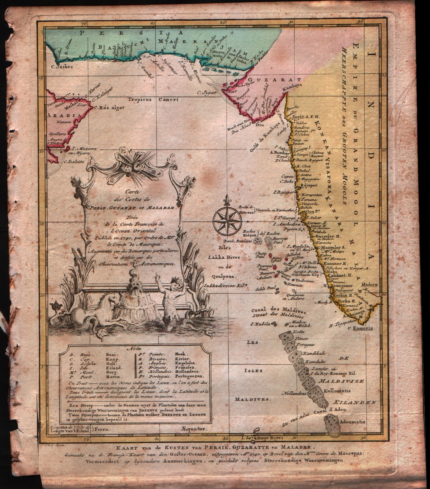
Map title
Carte des costes de Perse Gustarat et Malabar
Author
Bellin
Location shown in map
Moluccas
Edition date
1757
Edition place
Paris
Editor
--
Atlas
Historie General des Voyages -- Prevost
Price
Please ask: info@thetreasuremaps.com
State
[mint/EXCELLENT/very good/good/fair/mediocre/poor]
Color
Black/white
Verso
Blank
Size
Plate: cm (20.3 x 24.1) inches (7.99 x 9.49) Paper: cm (22.9 x 25.4) inches (9.02 x 10)
Technique
Copper engraving
Note
No particular notes for this maps
Reference
--
Wiki
Here for more info
In stock
Available
Info
info@thetreasuremaps.com
Code
#0229
×
![Carte des costes de Perse Gustarat et Malabar by Bellin, Moluccas, 1757]()
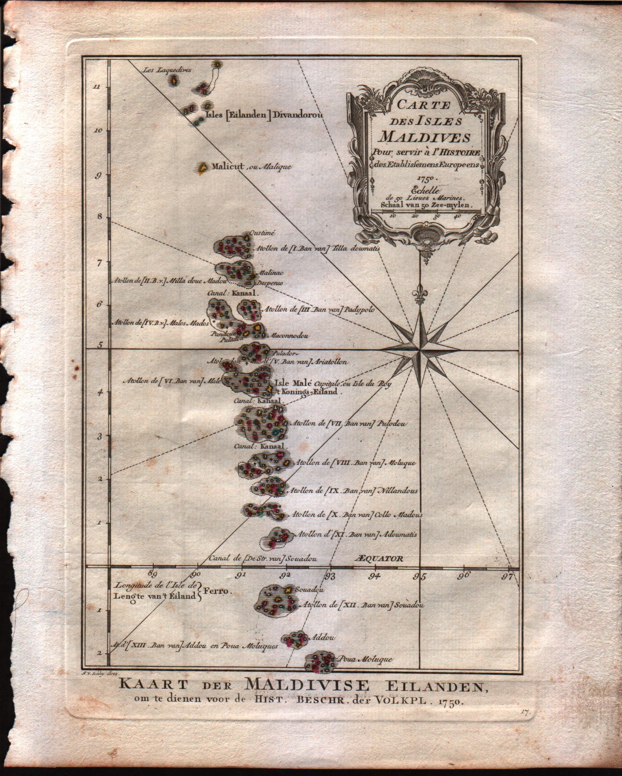
Map title
Carte des isles Maldives
Author
Bellin
Location shown in map
Maldives
Edition date
1757
Edition place
Paris
Editor
--
Atlas
Historie General des Voyages -- Prevost
Price
150 Euro
State
[mint/EXCELLENT/very good/good/fair/mediocre/poor]
Color
Black/white
Verso
Blank
Size
Plate: cm (15.2 x 21.6) inches (5.98 x 8.5) Paper: cm (15.2 x 22.9) inches (5.98 x 9.02)
Technique
Copper engraving
Note
No particular notes for this maps
Reference
--
Wiki
Here for more info
In stock
Available
Info
info@thetreasuremaps.com
Code
#0223
×
![Carte des isles Maldives by Bellin, Maldives, 1757]()
Map title
Suite de la carte de l'Indoustan, II feuille, comprendant la presqu'isle de l'Inde
Author
Bellin
Location shown in map
India
Edition date
1773
Edition place
Amsterdam
Editor
--
Atlas
Atlas Portatif -- E. van Harrevelt
Price
125 Euro
State
[mint/EXCELLENT/very good/good/fair/mediocre/poor]
Color
Old colors
Verso
Blank
Size
Plate: cm (24.1 x 21.6) inches (9.49 x 8.5) Paper: cm (33 x 26.7) inches (12.99 x 10.51)
Technique
Copper engraving
Note
No particular notes for this maps
Reference
--
Wiki
Here for more info
In stock
Available
Info
info@thetreasuremaps.com
Code
#0271
×
![Suite de la carte de l'Indoustan, II feuille, comprendant la presqu'isle de l'Inde by Bellin, India, 1773]()
Map title
Carte des costes de Perse, Guzarat et Malabar
Author
Bellin
Location shown in map
--
Edition date
1773
Edition place
Amsterdam
Editor
--
Atlas
Atlas Portatif -- E. van Harrevelt
Price
Please ask: info@thetreasuremaps.com
State
[mint/EXCELLENT/very good/good/fair/mediocre/poor]
Color
Old colors
Verso
Blank
Size
Plate: cm (20.3 x 24.1) inches (7.99 x 9.49) Paper: cm (22.9 x 27.9) inches (9.02 x 10.98)
Technique
Copper engraving
Note
No particular notes for this maps
Reference
--
Wiki
Here for more info
In stock
Sold
Info
info@thetreasuremaps.com
Code
#0270
×
![Carte des costes de Perse, Guzarat et Malabar by Bellin, --, 1773]()
Map title
Carte de l'isle de Ceylan
Author
Bellin
Location shown in map
--
Edition date
1773
Edition place
Amsterdam
Editor
--
Atlas
Atlas Portatif -- E. van Harrevelt
Price
125 Euro
State
[mint/EXCELLENT/very good/good/fair/mediocre/poor]
Color
Old colors
Verso
Blank
Size
Plate: cm (24.1 x 25.4) inches (9.49 x 10) Paper: cm (34.3 x 30.5) inches (13.5 x 12.01)
Technique
Copper engraving
Note
No particular notes for this maps
Reference
--
Wiki
Here for more info
In stock
Available
Info
info@thetreasuremaps.com
Code
#0266
×
![Carte de l'isle de Ceylan by Bellin, --, 1773]()
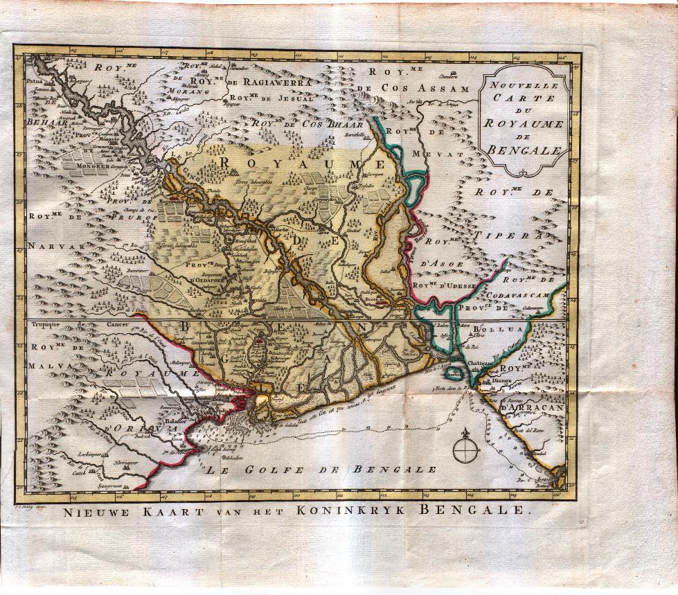
Map title
Nouvelle carte du royaume de Bengale
Author
Bellin
Location shown in map
--
Edition date
1773
Edition place
Amsterdam
Editor
--
Atlas
Atlas Portatif -- E. van Harrevelt
Price
150 Euro
State
[mint/EXCELLENT/very good/good/fair/mediocre/poor]
Color
Old colors
Verso
Blank
Size
Plate: cm (33 x 27.9) inches (12.99 x 10.98) Paper: cm (45.7 x 35.6) inches (17.99 x 14.02)
Technique
Copper engraving
Note
No particular notes for this maps
Reference
--
Wiki
Here for more info
In stock
Available
Info
info@thetreasuremaps.com
Code
#0264
×
![Nouvelle carte du royaume de Bengale by Bellin, --, 1773]()
Map title
Carte des Isles Maldives
Author
Bellin
Location shown in map
--
Edition date
1773
Edition place
Amsterdam
Editor
--
Atlas
Atlas Portatif -- E. van Harrevelt
Price
Please ask: info@thetreasuremaps.com
State
[mint/EXCELLENT/very good/good/fair/mediocre/poor]
Color
Old outlined
Verso
Blank
Size
Plate: cm (15.2 x 21.6) inches (5.98 x 8.5) Paper: cm (21.6 x 26.7) inches (8.5 x 10.51)
Technique
Copper engraving
Note
No particular notes for this maps
Reference
--
Wiki
Here for more info
In stock
Sold
Info
info@thetreasuremaps.com
Code
#0261
×
![Carte des Isles Maldives by Bellin, --, 1773]()

Map title
Hindostan
Author
Location shown in map
India
Edition date
Circa 1840
Edition place
Basel
Editor
Hindermann
Atlas
Price
50 Euro
State
[mint/EXCELLENT/very good/good/fair/mediocre/poor] repaired
Color
Black/white
Verso
Blank
Size
Plate: cm (21 x 25) inches (8.27 x 9.84) Paper: cm (24 x 29) inches (9.45 x 11.42)
Technique
Copper engraving
Note
Reference
Wiki
Here for more info
In stock
Available
Info
info@thetreasuremaps.com
Code
#1300
×
![Hindostan by , India, Circa 1840]()
Pages: 1 2