Liguria

Map title
Cursus Fluminis Padi vel Po per Longobardiam
Author
Homann
Location shown in map
Liguria
Edition date
1735
Edition place
Editor
Atlas
Atlas compendiarius
Price
300 Euro
State
[mint/EXCELLENT/very good/good/fair/mediocre/poor]
Color
Old colors
Verso
Blank
Size
Plate: cm (60 x 54) inches (23.62 x 21.26) Paper: cm (58 x 50) inches (22.83 x 19.69)
Technique
Copper engraving
Note
Reference
Wiki
Here for more info
In stock
Available
Info
info@thetreasuremaps.com
Code
#1228
×
![Cursus Fluminis Padi vel Po per Longobardiam by Homann, Liguria, 1735]()
Map title
Republicae Genuensis dominium
Author
Seutter, Matthaus
Location shown in map
Liguria
Edition date
1740
Edition place
Augsburg
Editor
Atlas
Atlas Novus sive Tabulae Geographicae totius orbis faciem, partes, imperia, regna et provincias exhibentes exactissima cura iuxta recontissimas observation
Price
500 Euro
State
[mint/excellent/VERY GOOD/good/fair/mediocre/poor]
Color
Old colors
Verso
Blank
Size
Plate: cm (58 x 48) inches (22.83 x 18.9) Paper: cm (67 x 54) inches (26.38 x 21.26)
Technique
Copper engraving
Note
Reference
Wiki
Here for more info
In stock
Available
Info
info@thetreasuremaps.com
Code
#0911
×
![Republicae Genuensis dominium by Seutter, Matthaus, Liguria, 1740]()
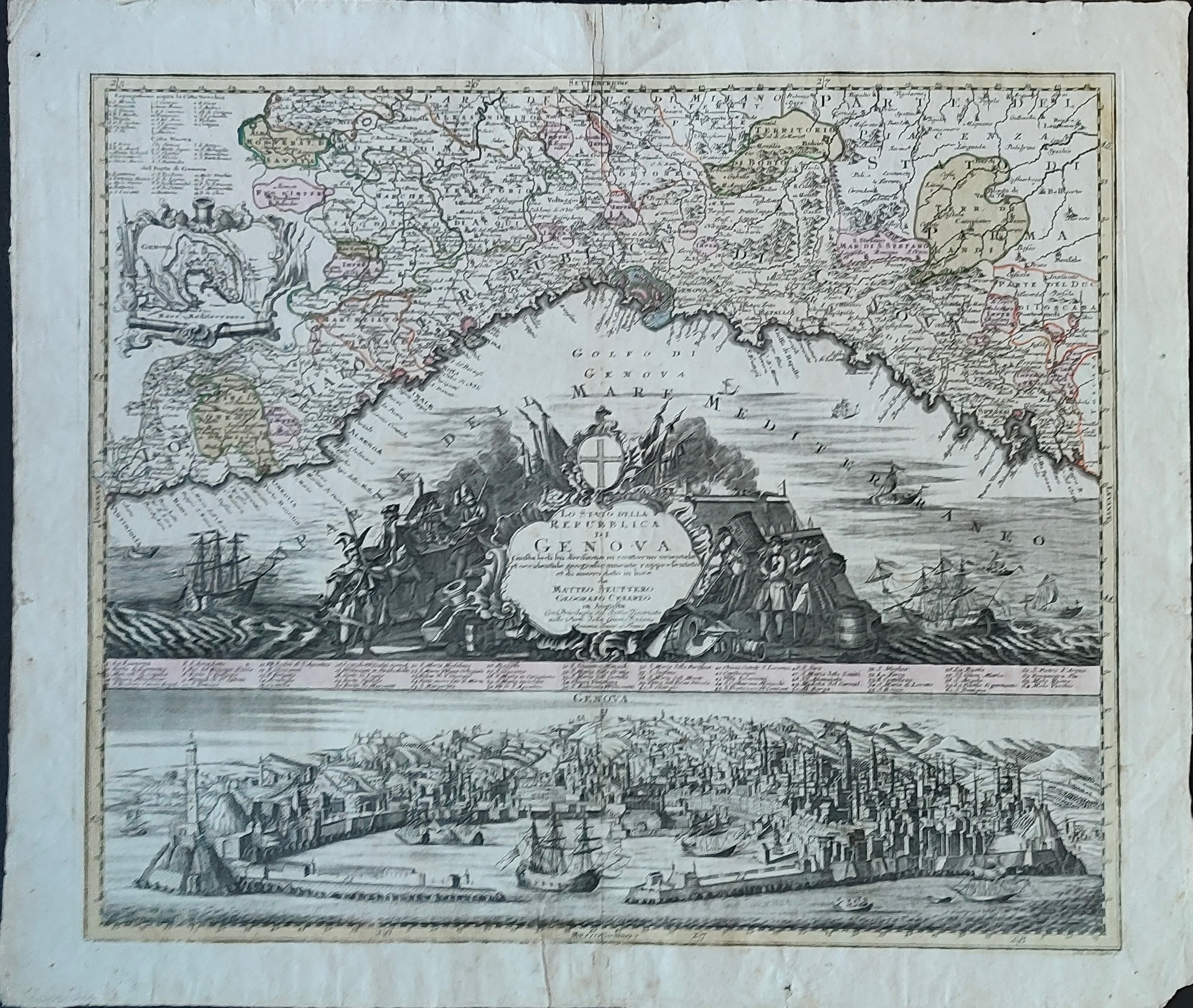
Map title
Carta Geographica, la quale rappresenta lo Stato della Republica di Genova
Author
Homann
Location shown in map
Liguria
Edition date
1743
Edition place
Nuremberg
Editor
Atlas
Price
900 Euro
State
[mint/EXCELLENT/very good/good/fair/mediocre/poor]
Color
Old colors
Verso
Blank
Size
Plate: cm (56 x 50) inches (22.05 x 19.69) Paper: cm (63 x 52) inches (24.8 x 20.47)
Technique
Copper engraving
Note
Reference
Wiki
Here for more info
In stock
Available
Info
info@thetreasuremaps.com
Code
#1198
×
![Carta Geographica, la quale rappresenta lo Stato della Republica di Genova by Homann, Liguria, 1743]()
Map title
Carta Geographica, la quale rappresenta lo Stato della Republica di Genova
Author
Homann
Location shown in map
Liguria
Edition date
1743
Edition place
Nuremberg
Editor
Atlas
Price
900 Euro
State
[mint/EXCELLENT/very good/good/fair/mediocre/poor]
Color
Old colors
Verso
Blank
Size
Plate: cm (56 x 50) inches (22.05 x 19.69) Paper: cm (63 x 52) inches (24.8 x 20.47)
Technique
Copper engraving
Note
Framed
Reference
Wiki
Here for more info
In stock
Available
Info
info@thetreasuremaps.com
Code
#1384
×
![Carta Geographica, la quale rappresenta lo Stato della Republica di Genova by Homann, Liguria, 1743]()
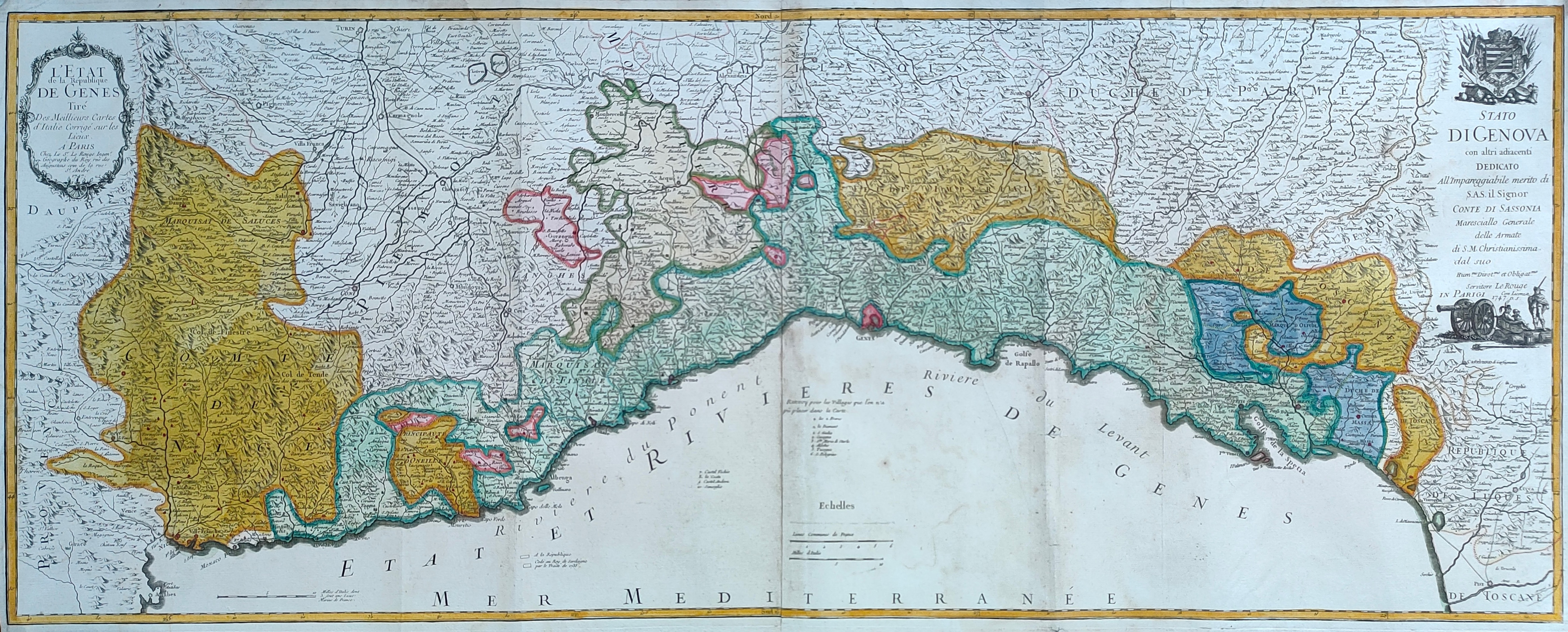
Map title
L'Etat de la republique de Genes
Author
Le Rouge
Location shown in map
Liguria
Edition date
1747
Edition place
Paris
Editor
Atlas
Price
300 Euro
State
[mint/EXCELLENT/very good/good/fair/mediocre/poor]
Color
Old colors
Verso
Blank
Size
Plate: cm (55 x 44) inches (21.65 x 17.32) Paper: cm (60 x 49) inches (23.62 x 19.29)
Technique
Copper engraving
Note
Reference
Wiki
Here for more info
In stock
Available
Info
info@thetreasuremaps.com
Code
#1203
×
![L'Etat de la republique de Genes by Le Rouge, Liguria, 1747]()
Map title
Lo stato della repubblica di Genova
Author
Seutter, Matthaus
Location shown in map
Liguria
Edition date
1747
Edition place
Augsburg
Editor
Lotter
Atlas
Atlas Novus sive Tabulae Geographicae totius orbis faciem, partes, imperia, regna et provincias exhibentes exactissima cura iuxta recontissimas observation
Price
800 Euro
State
[mint/EXCELLENT/very good/good/fair/mediocre/poor]
Color
Old colors
Verso
Blank
Size
Plate: cm (57 x 48) inches (22.44 x 18.9) Paper: cm (67 x 56) inches (26.38 x 22.05)
Technique
Copper engraving
Note
Reference
L.Tricerri, Catalog of Maps of Liguria R_114
Wiki
Here for more info
In stock
Available
Info
info@thetreasuremaps.com
Code
#1336
×
![Lo stato della repubblica di Genova by Seutter, Matthaus, Liguria, 1747]()
Map title
L'Etat de la republique de Genes
Author
Le Rouge
Location shown in map
Liguria
Edition date
1747
Edition place
Paris
Editor
Atlas
Price
600 Euro
State
[mint/EXCELLENT/very good/good/fair/mediocre/poor]
Color
Old colors
Verso
Blank
Size
Plate: cm (110 x 44) inches (43.31 x 17.32) Paper: cm (114 x 48) inches (44.88 x 18.9)
Technique
Copper engraving
Note
Reference
Wiki
Here for more info
In stock
Available
Info
info@thetreasuremaps.com
Code
#1245
×
![L'Etat de la republique de Genes by Le Rouge, Liguria, 1747]()
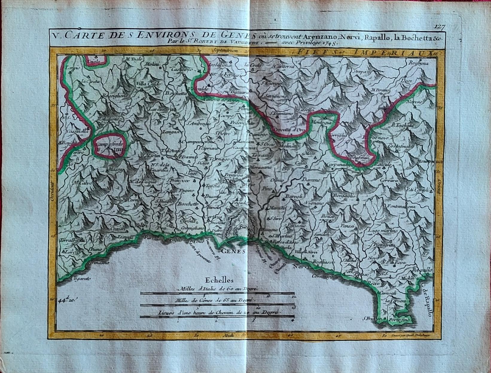
Map title
Carte des environs de Genes
Author
Vaugondy
Location shown in map
Liguria
Edition date
1748
Edition place
Paris
Editor
Atlas
Price
175 Euro
State
[mint/EXCELLENT/very good/good/fair/mediocre/poor]
Color
Old colors
Verso
Blank
Size
Plate: cm (20 x 15.5) inches (7.87 x 6.1) Paper: cm (24 x 19) inches (9.45 x 7.48)
Technique
Copper engraving
Note
Reference
Wiki
Here for more info
In stock
Available
Info
info@thetreasuremaps.com
Code
#1264
×
![Carte des environs de Genes by Vaugondy, Liguria, 1748]()
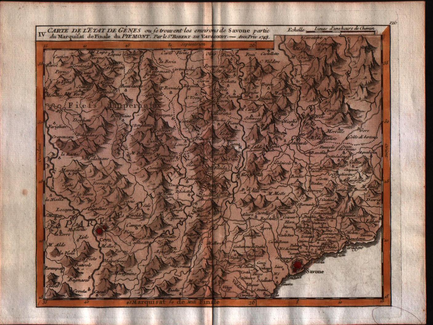
Map title
Carte de l'Etat de Genes, ou se trouvent les environs de Savone partie du Marquisat de Finale du Piemont.
Author
Robert de Vaugondy
Location shown in map
Liguria
Edition date
1748
Edition place
Paris
Editor
Durand & Pissot
Atlas
Atlas portatif universel et militaire
Price
150 Euro
State
[MINT/excellent/very good/good/fair/mediocre/poor]
Color
Old colors
Verso
Blank
Size
Plate: cm (20.3 x 15.2) inches (7.99 x 5.98) Paper: cm (24.1 x 19) inches (9.49 x 7.48)
Technique
Copper engraving
Note
No particular notes for this maps.
Reference
--
Wiki
Here for more info
In stock
Available
Info
info@thetreasuremaps.com
Code
#0554
×
![Carte de l'Etat de Genes, ou se trouvent les environs de Savone partie du Marquisat de Finale du Piemont. by Robert de Vaugondy, Liguria, 1748]()
Map title
Status Genuensis
Author
Tobias Mayer
Location shown in map
Liguria
Edition date
1749
Edition place
Nuremberg
Editor
Homann
Atlas
Atlas Compendiarius: Quinquaginta Tabularum Geographicarum Homannianarum alias in Atlante maiori contentarum
Price
Please ask: info@thetreasuremaps.com
State
[mint/EXCELLENT/very good/good/fair/mediocre/poor]
Color
Old colors
Verso
Blank
Size
Plate: cm (48 x 39) inches (18.9 x 15.35) Paper: cm (60 x 52) inches (23.62 x 20.47)
Technique
Copper engraving
Note
--
Reference
--
Wiki
Here for more info
In stock
Available
Info
info@thetreasuremaps.com
Code
#0629
×
![Status Genuensis by Tobias Mayer, Liguria, 1749]()
Map title
Carta qui contient la proncipate de Piemont le Monferrat
Author
Santini
Location shown in map
Liguria
Edition date
1776
Edition place
Venice
Editor
Atlas
Price
200 Euro
State
[mint/EXCELLENT/very good/good/fair/mediocre/poor]
Color
Black/white
Verso
Blank
Size
Plate: cm (47 x 64) inches (18.5 x 25.2) Paper: cm (50 x 68) inches (19.69 x 26.77)
Technique
Copper engraving
Note
Reference
Wiki
Here for more info
In stock
Available
Info
info@thetreasuremaps.com
Code
#1054
×
![Carta qui contient la proncipate de Piemont le Monferrat by Santini, Liguria, 1776]()
Map title
A Topographical Map of the Republick of Genova
Author
Gravier
Location shown in map
Liguria
Edition date
1784
Edition place
Genoa
Editor
Gravier
Atlas
Price
2500 Euro
State
[mint/EXCELLENT/very good/good/fair/mediocre/poor]
Color
Black/white
Verso
Blank
Size
Plate: cm (1855 x 1060) inches (730.31 x 417.32) Paper: cm (1855 x 1060) inches (730.31 x 417.32)
Technique
Copper engraving
Note
Reference
L.Tricerri, Catalog of Maps of Liguria R_093
Wiki
Here for more info
In stock
Available
Info
info@thetreasuremaps.com
Code
#1361
×
![A Topographical Map of the Republick of Genova by Gravier, Liguria, 1784]()
Map title
Stato della Repubblica di Genova
Author
Zatta
Location shown in map
Liguria
Edition date
1785
Edition place
Venice
Editor
Atlas
Atlante novissimo, illustrato ed accresciuto sulle osservazioni e scoperte fatte dai più celebri e più recenti geografi
Price
350 Euro
State
[mint/EXCELLENT/very good/good/fair/mediocre/poor]
Color
Old colors
Verso
Blank
Size
Plate: cm (31 x 42) inches (12.2 x 16.54) Paper: cm (48 x 39) inches (18.9 x 15.35)
Technique
Copper engraving
Note
Reference
L.Tricerri, Catalog of Maps of Liguria R_095
Wiki
Here for more info
In stock
Available
Info
info@thetreasuremaps.com
Code
#1335
×
![Stato della Repubblica di Genova by Zatta, Liguria, 1785]()
Map title
Etats de la seigneurie et republique de Gènes.
Author
Remondini
Location shown in map
Liguria
Edition date
1804
Edition place
Venice
Editor
Atlas
Price
600 Euro
State
[mint/EXCELLENT/very good/good/fair/mediocre/poor]
Color
Old colors
Verso
Blank
Size
Plate: cm (68 x 49) inches (26.77 x 19.29) Paper: cm (72 x 52) inches (28.35 x 20.47)
Technique
Copper engraving
Note
Never inserted in atlas
Reference
L.Tricerri, Catalog of Maps of Liguria R_138
Wiki
Here for more info
In stock
Available
Info
info@thetreasuremaps.com
Code
#1339
×
![Etats de la seigneurie et republique de Gènes.
by Remondini, Liguria, 1804]()
Map title
Carta militare di Genova e suoi contorni
Author
Pinchetti
Location shown in map
Genoa
Edition date
Circa 1830
Edition place
Milan
Editor
Atlas
Price
400 Euro
State
[mint/EXCELLENT/very good/good/fair/mediocre/poor]
Color
Old colors
Verso
Blank
Size
Plate: cm (45 x 52) inches (17.72 x 20.47) Paper: cm (59 x 71) inches (23.23 x 27.95)
Technique
Copper engraving
Note
Reference
Wiki
Here for more info
In stock
Available
Info
info@thetreasuremaps.com
Code
#1340
×
![Carta militare di Genova e suoi contorni
by Pinchetti, Genoa, Circa 1830]()
Map title
Kingdom of Sardinia
Author
Hamilton
Location shown in map
Liguria
Edition date
1831
Edition place
Edinburgh
Editor
Daniel Lizars
Atlas
The Edinburgh Geographical and Historical Atlas
Price
150 Euro
State
[mint/EXCELLENT/very good/good/fair/mediocre/poor]
Color
Old colors
Verso
Blank
Size
Plate: cm (49 x 38) inches (19.29 x 14.96) Paper: cm (55 x 47) inches (21.65 x 18.5)
Technique
Copper engraving
Note
Reference
Wiki
Here for more info
In stock
Available
Info
info@thetreasuremaps.com
Code
#1223
×
![Kingdom of Sardinia by Hamilton, Liguria, 1831]()
Map title
Carta Nuovissima geografica e stradale dell'Attual Piemonte
Author
Nicola Ombrelaro
Location shown in map
Liguria
Edition date
1837
Edition place
Torino
Editor
--
Atlas
--
Price
Euro
State
[mint/excellent/VERY GOOD/good/fair/mediocre/poor]
Color
Black/white
Verso
Blank
Size
Plate: cm (61 x 50.8) inches (24.02 x 20) Paper: cm (71.1 x 55.9) inches (27.99 x 22.01)
Technique
Steel engraving
Note
--
Reference
--
Wiki
Here for more info
In stock
Available
Info
info@thetreasuremaps.com
Code
#0509
×
![Carta Nuovissima geografica e stradale dell'Attual Piemonte by Nicola Ombrelaro, Liguria, 1837]()
Map title
Liguria
Author
Duvotenay
Location shown in map
Liguria
Edition date
Circa 1840
Edition place
Paris
Editor
Atlas
Price
50 Euro
State
[mint/excellent/very good/good/FAIR/mediocre/poor]
Color
Black/white
Verso
Blank
Size
Plate: cm (36 x 21) inches (14.17 x 8.27) Paper: cm (43 x 28) inches (16.93 x 11.02)
Technique
Steel engraving
Note
Reference
Wiki
Here for more info
In stock
Available
Info
info@thetreasuremaps.com
Code
#1306
Liguria
Author
Duvotenay
Location shown in map
Liguria
Edition date
Circa 1840
Edition place
Paris
Editor
Atlas
Price
50 Euro
State
[mint/excellent/very good/good/FAIR/mediocre/poor]
Color
Black/white
Verso
Blank
Size
Plate: cm (36 x 21) inches (14.17 x 8.27) Paper: cm (43 x 28) inches (16.93 x 11.02)
Technique
Steel engraving
Note
Reference
Wiki
Here for more info
In stock
Available
Info
info@thetreasuremaps.com
Code
#1306
×
![Liguria by Duvotenay, Liguria, Circa 1840]()
Map title
Carta moderna degli stati sardi di terraferme
Author
Zuccagni
Location shown in map
Liguria
Edition date
1844
Edition place
Firenze
Editor
Vallardi
Atlas
Atlante Geografico dell'Italia
Price
175 Euro
State
[mint/EXCELLENT/very good/good/fair/mediocre/poor]
Color
Old colors
Verso
Blank
Size
Plate: cm (70 x 54) inches (27.56 x 21.26) Paper: cm (82 x 58) inches (32.28 x 22.83)
Technique
Steel engraving
Note
Reference
Wiki
Here for more info
In stock
Available
Info
info@thetreasuremaps.com
Code
#1115
×
![Carta moderna degli stati sardi di terraferme by Zuccagni, Liguria, 1844]()
Map title
Carta del ducato di Genova
Author
Doyen
Location shown in map
Liguria
Edition date
1846
Edition place
Turin
Editor
Atlas
Price
250 Euro
State
[mint/EXCELLENT/very good/good/fair/mediocre/poor]
Color
Black/white
Verso
Blank
Size
Plate: cm (0 x 0) inches (0 x 0) Paper: cm (0 x 0) inches (0 x 0)
Technique
Steel engraving
Note
Reference
Wiki
Here for more info
In stock
Available
Info
info@thetreasuremaps.com
Code
#1025
×
![Carta del ducato di Genova by Doyen, Liguria, 1846]()