North America
Pages: 1 2
Map title
Tierra Nueva
Author
Ruscelli
Location shown in map
East coast
Edition date
1561
Edition place
Venice
Editor
Vincenzo Valgrisi
Atlas
La Geographia di Claudio Tolomeo
Price
900 Euro
State
[mint/excellent/VERY GOOD/good/fair/mediocre/poor]
Color
Black/white
Verso
Italian text pag.59
Size
Plate: cm (25.4 x 19) inches (10 x 7.48) Paper: cm (27.9 x 20.3) inches (10.98 x 7.99)
Technique
Copper engraving
Note
No particular notes for this maps.
Reference
--
Wiki
Here for more info
In stock
Available
Info
info@thetreasuremaps.com
Code
#0529
×
![Tierra Nueva by Ruscelli, East coast, 1561]()
Map title
Tierra Nueva
Author
Ruscelli
Location shown in map
East coast
Edition date
1561
Edition place
Venice
Editor
Vincenzo Valgrisi
Atlas
La Geographia di Claudio Tolomeo
Price
900 Euro
State
[mint/EXCELLENT/very good/good/fair/mediocre/poor]
Color
Black/white
Verso
Italian text pag.32
Size
Plate: cm (26 x 19) inches (10.24 x 7.48) Paper: cm (27.9 x 20.3) inches (10.98 x 7.99)
Technique
Copper engraving
Note
No particular notes for this maps.
Reference
--
Wiki
Here for more info
In stock
Available
Info
info@thetreasuremaps.com
Code
#0767
×
![Tierra Nueva by Ruscelli, East coast, 1561]()
Map title
Nova Virginiae tabula
Author
Pieter van den Keere
Location shown in map
Virginiae
Edition date
1628
Edition place
Amsterdam
Editor
Janssonius
Atlas
Altas Minor Gerardi Mercatoris
Price
400 Euro
State
[mint/EXCELLENT/very good/good/fair/mediocre/poor]
Color
Black/white
Verso
French text pag.632
Size
Plate: cm (19 x 13) inches (7.48 x 5.12) Paper: cm (22 x 17) inches (8.66 x 6.69)
Technique
Copper engraving
Note
No particular notes for this maps.
Reference
--
Wiki
Here for more info
In stock
Available
Info
info@thetreasuremaps.com
Code
#0655
×
![Nova Virginiae tabula by Pieter van den Keere, Virginiae, 1628]()
Map title
L'America Settentrionale
Author
De Rossi
Location shown in map
North America
Edition date
1677
Edition place
Rome
Editor
De Rossi
Atlas
Mercurio Geografico
Price
1600 Euro
State
[mint/EXCELLENT/very good/good/fair/mediocre/poor]
Color
Old colors
Verso
Blank
Size
Plate: cm (55 x 39) inches (21.65 x 15.35) Paper: cm (60 x 48) inches (23.62 x 18.9)
Technique
Copper engraving
Note
Reference
Wiki
Here for more info
In stock
Sold
Info
info@thetreasuremaps.com
Code
#0983
×
![L'America Settentrionale by De Rossi, North America, 1677]()

Map title
America Settentrional
Author
Sanson
Location shown in map
North America
Edition date
1680
Edition place
--
Editor
--
Atlas
--
Price
Please ask: info@thetreasuremaps.com
State
[mint/excellent/VERY GOOD/good/fair/mediocre/poor]
Color
Black/white
Verso
Blank
Size
Plate: cm (16.5 x 14) inches (6.5 x 5.51) Paper: cm (20.3 x 20.3) inches (7.99 x 7.99)
Technique
Copper engraving
Note
California as an island
Reference
--
Wiki
Here for more info
In stock
Sold
Info
info@thetreasuremaps.com
Code
#0406
×
![America Settentrional by Sanson, North America, 1680]()
Map title
Le Canada ou Novelle France
Author
Sanson
Location shown in map
North America
Edition date
Circa 1683
Edition place
Paris
Editor
Atlas
L'Europe en Plusieurs Cartes, et en divers Traittes de Geographie et d'Histoire.
Price
400 Euro
State
[mint/EXCELLENT/very good/good/fair/mediocre/poor]
Color
Old colors
Verso
Blank
Size
Plate: cm (30 x 21) inches (11.81 x 8.27) Paper: cm (32 x 22) inches (12.6 x 8.66)
Technique
Copper engraving
Note
Reference
Wiki
Here for more info
In stock
Available
Info
info@thetreasuremaps.com
Code
#0997
×
![Le Canada ou Novelle France by Sanson, North America, Circa 1683]()
Map title
Mondo nuovo
Author
Porcacchi
Location shown in map
North America
Edition date
1686
Edition place
Venice
Editor
--
Atlas
L'Isole piu famose del mondo -- Pietr'Antonio Brigonci
Price
800 Euro
State
[mint/excellent/very good/good/fair/MEDIOCRE/poor]
Color
Black/white
Verso
Blank
Size
Plate: cm (14 x 11.4) inches (5.51 x 4.49) Paper: cm (17.8 x 16.5) inches (7.01 x 6.5)
Technique
Copper engraving
Note
Late edition for this beautiful map
Reference
--
Wiki
Here for more info
In stock
Available
Info
info@thetreasuremaps.com
Code
#0055
×
![Mondo nuovo by Porcacchi, North America, 1686]()
Map title
Islands
Author
Coronelli
Location shown in map
Bermuda, Iceland, Newfounland, Mayen
Edition date
Circa 1692
Edition place
Venice
Editor
--
Atlas
Atlante veneto
Price
1600 Euro
State
[mint/excellent/VERY GOOD/good/fair/mediocre/poor] Upper margin damaged
Color
Black/white
Verso
Blank
Size
Plate: cm (61 x 45.7) inches (24.02 x 17.99) Paper: cm (68.6 x 48.3) inches (27.01 x 19.02)
Technique
Copper engraving
Note
4 maps
Reference
--
Wiki
Here for more info
In stock
Available
Info
info@thetreasuremaps.com
Code
#0056
×
![Islands by Coronelli, Bermuda, Iceland, Newfounland, Mayen, Circa 1692]()
Map title
Isola di capo Breton
Author
Coronelli
Location shown in map
Cape Breton island
Edition date
Circa 1696
Edition place
Venice
Editor
Coronelli
Atlas
Atlante veneto
Price
200 Euro
State
[MINT/excellent/very good/good/fair/mediocre/poor]
Color
Black/white
Verso
Italian text
Size
Plate: cm (16.5 x 12.7) inches (6.5 x 5) Paper: cm (50.8 x 35.6) inches (20 x 14.02)
Technique
Copper engraving
Note
No particular notes for this maps.
Reference
--
Wiki
Here for more info
In stock
Available
Info
info@thetreasuremaps.com
Code
#0569
×
![Isola di capo Breton by Coronelli, Cape Breton island, Circa 1696]()
Map title
Carte Particuliere Du Fleuve Saint Louis Dressee Sure Les Lieux Avec Les Noms Des Sauvages Du Pais
Author
Henri Chatelain
Location shown in map
Canada & North America
Edition date
1708
Edition place
Amsterdam
Editor
--
Atlas
Atlas Historique
Price
Please ask: info@thetreasuremaps.com
State
[mint/EXCELLENT/very good/good/fair/mediocre/poor]
Color
Black/white
Verso
Blank
Size
Plate: cm (35.6 x 45.7) inches (14.02 x 17.99) Paper: cm (35.6 x 45.7) inches (14.02 x 17.99)
Technique
Copper engraving
Note
Key giving historical & geographical information
Reference
--
Wiki
Here for more info
In stock
Sold
Info
info@thetreasuremaps.com
Code
#0057
×
![Carte Particuliere Du Fleuve Saint Louis Dressee Sure Les Lieux Avec Les Noms Des Sauvages Du Pais by Henri Chatelain, Canada & North America, 1708]()
Map title
Carte qui contient une description des iles & terres que les Anglois possedent dans l'Amerique septentrionale, et en particulier de la Jamaique, des Iles Barbades, de la Nouvelle Angleterre, Des Barmudes,de la Caroline, de la Pensilvanie, et du New-Foundland, avec un Etat de Chaque Pais
Author
Henri Chatelain
Location shown in map
North America
Edition date
1719
Edition place
Amsterdam
Editor
Atlas
Atlas Historique
Price
200 Euro
State
[mint/excellent/VERY GOOD/good/fair/mediocre/poor]
Color
Black/white
Verso
Blank
Size
Plate: cm (52 x 42) inches (20.47 x 16.54) Paper: cm (53 x 43) inches (20.87 x 16.93)
Technique
Copper engraving
Note
Reference
Wiki
Here for more info
In stock
Available
Info
info@thetreasuremaps.com
Code
#0811
×
![Carte qui contient une description des iles & terres que les Anglois possedent dans l'Amerique septentrionale, et en particulier de la Jamaique, des Iles Barbades, de la Nouvelle Angleterre, Des Barmudes,de la Caroline, de la Pensilvanie, et du New-Foundland, avec un Etat de Chaque Pais by Henri Chatelain, North America, 1719]()
Map title
L'America Setten.
Author
De L'Isle
Location shown in map
North America
Edition date
Circa 1720
Edition place
Editor
Atlas
Price
Please ask: info@thetreasuremaps.com
State
[mint/EXCELLENT/very good/good/fair/mediocre/poor]
Color
Black/white
Verso
Blank
Size
Plate: cm (17 x 14) inches (6.69 x 5.51) Paper: cm (18 x 16) inches (7.09 x 6.3)
Technique
Copper engraving
Note
Reference
Wiki
Here for more info
In stock
Available
Info
info@thetreasuremaps.com
Code
#0940
×
![L'America Setten. by De L'Isle, North America, Circa 1720]()
Map title
America Settentrional
Author
Sanson
Location shown in map
North America
Edition date
Circa 1720
Edition place
Editor
Atlas
Price
250 Euro
State
[mint/EXCELLENT/very good/good/fair/mediocre/poor]
Color
Black/white
Verso
Blank
Size
Plate: cm (16.5 x 15) inches (6.5 x 5.91) Paper: cm (24 x 19) inches (9.45 x 7.48)
Technique
Copper engraving
Note
California as an island
Reference
--
Wiki
Here for more info
In stock
Available
Info
info@thetreasuremaps.com
Code
#1140
×
![America Settentrional by Sanson, North America, Circa 1720]()
Map title
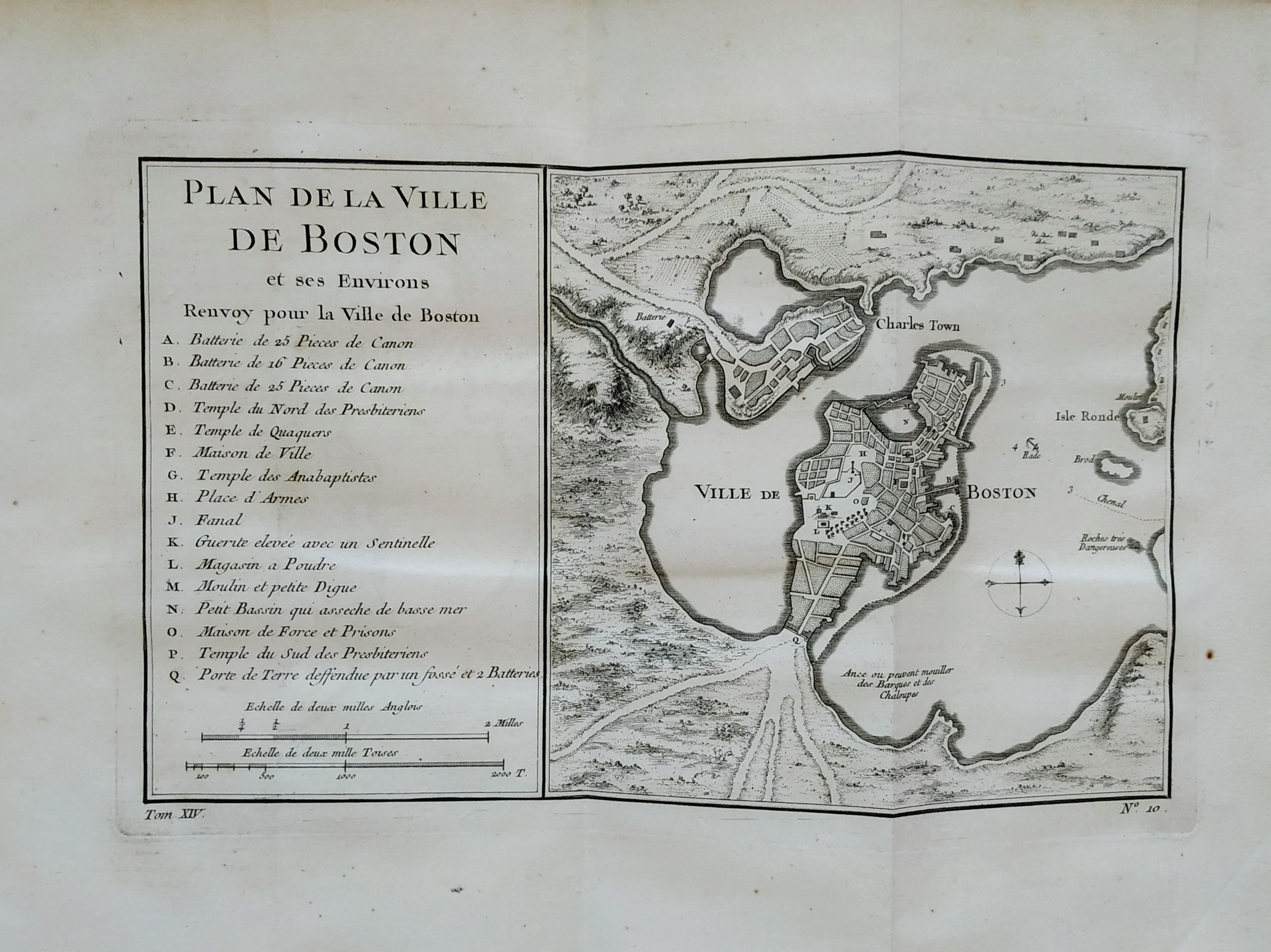
Plan de la ville de Boston
Author
Bellin
Location shown in map
Boston
Edition date
1757
Edition place
Paris
Editor
Prevost
Atlas
Historie General des Voyages -- Prevost
Price
300 Euro
State
[mint/EXCELLENT/very good/good/fair/mediocre/poor]
Color
Black/white
Verso
Blank
Size
Plate: cm (27 x 16) inches (10.63 x 6.3) Paper: cm (36 x 28) inches (14.17 x 11.02)
Technique
Copper engraving
Note
No particular notes for this maps
Reference
--
Wiki
Here for more info
In stock
Sold
Info
info@thetreasuremaps.com
Code
#0757
×
![Plan de la ville de Boston by Bellin, Boston, 1757]()
Map title
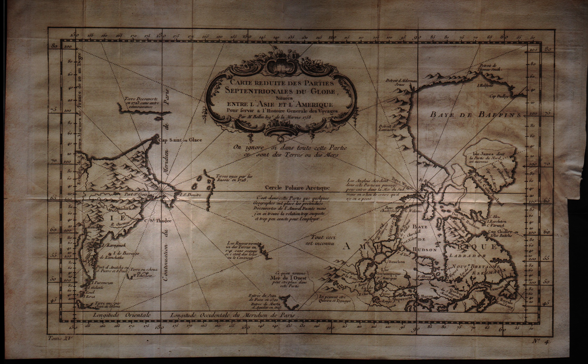
Carte reduite des parties Septentrionales du Globe situees entre l'Asie et l'Amerique
Author
Bellin
Location shown in map
--
Edition date
1757
Edition place
Paris
Editor
--
Atlas
Historie General des Voyages -- Prevost
Price
200 Euro
State
[mint/excellent/VERY GOOD/good/fair/mediocre/poor]
Color
Black/white
Verso
Blank
Size
Plate: cm (34.3 x 21.6) inches (13.5 x 8.5) Paper: cm (38.1 x 25.4) inches (15 x 10)
Technique
Copper engraving
Note
No particular notes for this maps
Reference
--
Wiki
Here for more info
In stock
Available
Info
info@thetreasuremaps.com
Code
#0064
×
![Carte reduite des parties Septentrionales du Globe situees entre l'Asie et l'Amerique by Bellin, --, 1757]()
Map title
Partie Orientale de L'Amerique Septentrionale
Author
Tardieu
Location shown in map
--
Edition date
1762
Edition place
--
Editor
--
Atlas
--
Price
Please ask: info@thetreasuremaps.com
State
[mint/EXCELLENT/very good/good/fair/mediocre/poor]
Color
Black/white
Verso
Blank
Size
Plate: cm (34.3 x 21.6) inches (13.5 x 8.5) Paper: cm (40.6 x 25.4) inches (15.98 x 10)
Technique
Copper engraving
Note
No particular notes for this maps
Reference
--
Wiki
Here for more info
In stock
Sold
Info
info@thetreasuremaps.com
Code
#0387
×
![Partie Orientale de L'Amerique Septentrionale by Tardieu, --, 1762]()
Map title
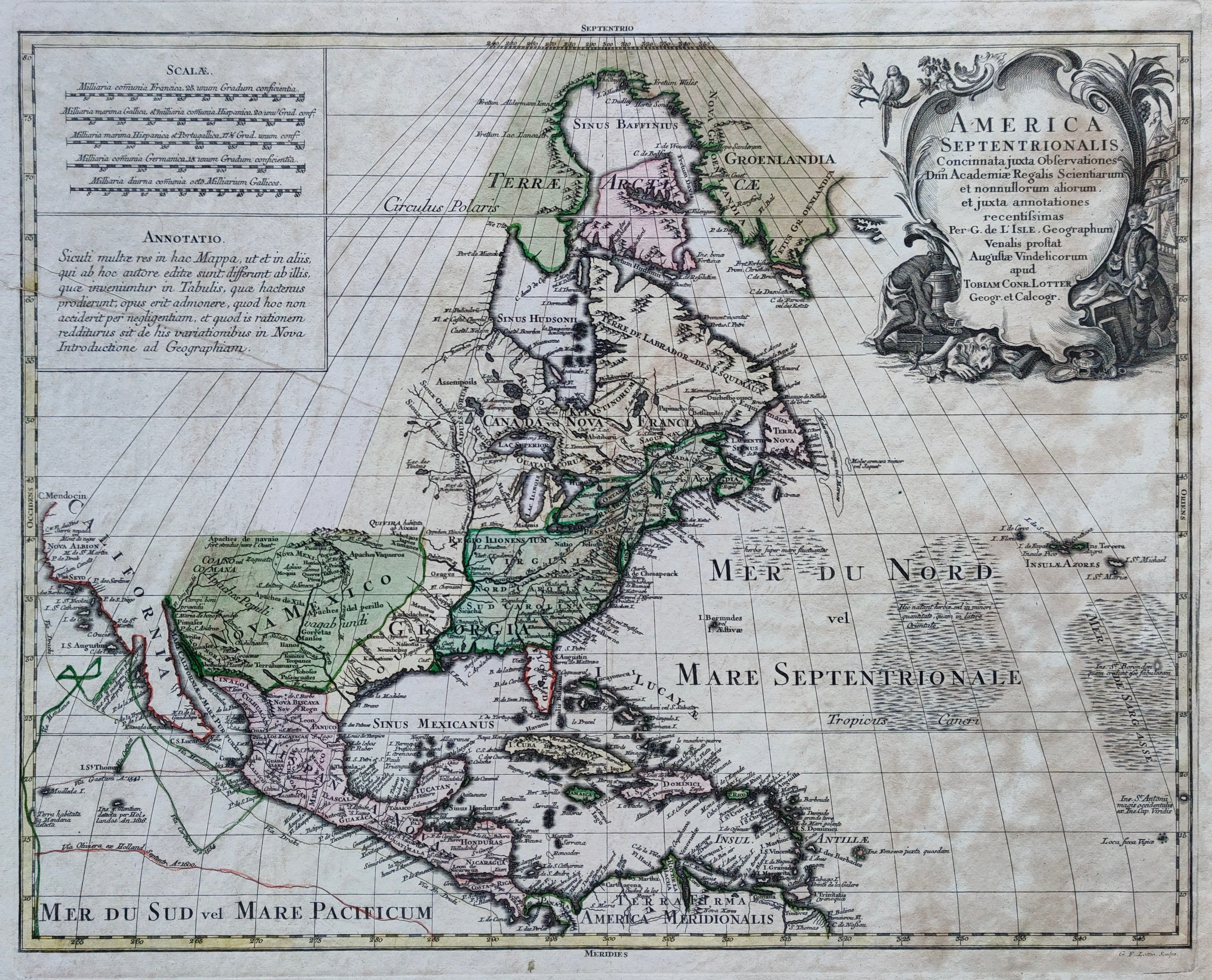
America Septentrionalis
Author
Lotter
Location shown in map
North America
Edition date
Circa 1770
Edition place
Augsburg
Editor
Atlas
Price
600 Euro
State
[mint/EXCELLENT/very good/good/fair/mediocre/poor]
Color
Old colors
Verso
Blank
Size
Plate: cm (59 x 45) inches (23.23 x 17.72) Paper: cm (74 x 59) inches (29.13 x 23.23)
Technique
Copper engraving
Note
Reference
--
Wiki
Here for more info
In stock
Available
Info
info@thetreasuremaps.com
Code
#1209
×
![America Septentrionalis by Lotter, North America, Circa 1770]()
Map title
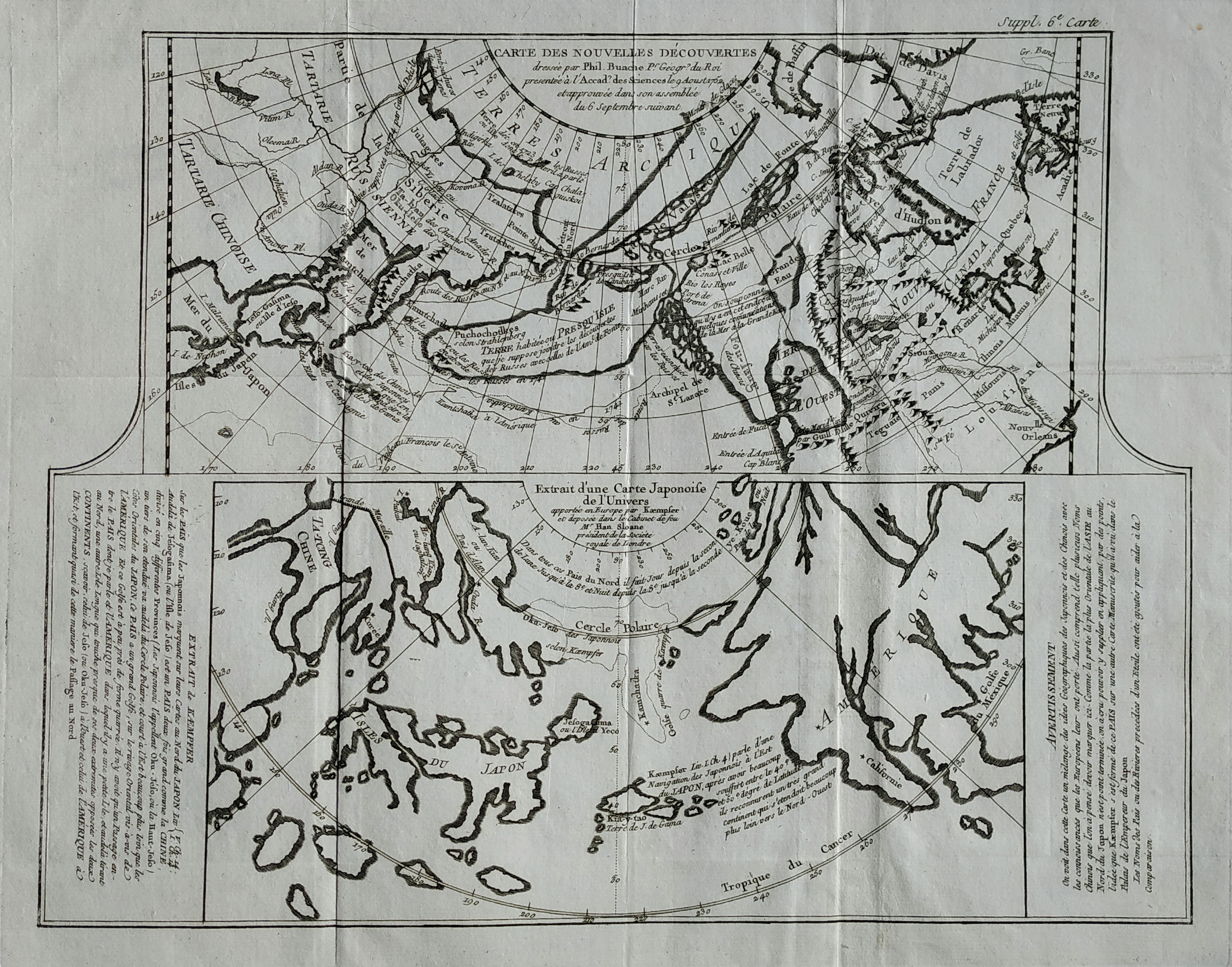
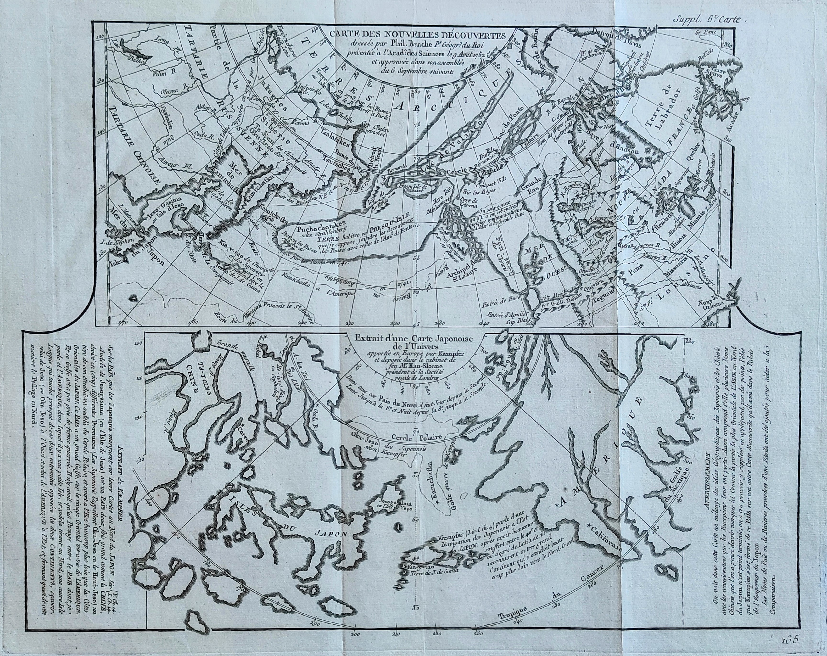
Carte des nouvelles decouvertes
Author
Diderot
Location shown in map
North America
Edition date
1772
Edition place
Paris
Editor
--
Atlas
Encyclopedie -- De Vaugondy
Price
125 Euro
State
[mint/EXCELLENT/very good/good/fair/mediocre/poor]
Color
Black/white
Verso
Blank
Size
Plate: cm (40.6 x 31.8) inches (15.98 x 12.52) Paper: cm (50.8 x 40.6) inches (20 x 15.98)
Technique
Copper engraving
Note
No particular notes for this maps
Reference
--
Wiki
Here for more info
In stock
Available
Info
info@thetreasuremaps.com
Code
#0081
×
![Carte des nouvelles decouvertes by Diderot, North America, 1772]()
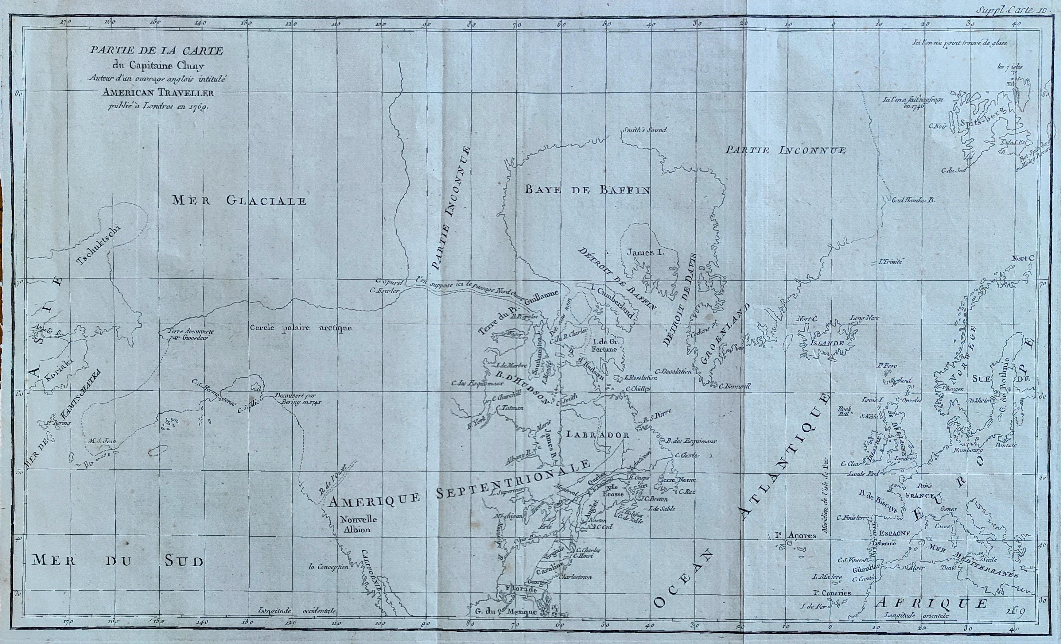
Map title
Partie de la carte du Capitaine Cluny
Author
Diderot
Location shown in map
North America
Edition date
1772
Edition place
Paris
Editor
Diderot
Atlas
Encyclopedie -- De Vaugondy
Price
250 Euro
State
[mint/EXCELLENT/very good/good/fair/mediocre/poor]
Color
Black/white
Verso
Blank
Size
Plate: cm (49.5 x 29.2) inches (19.49 x 11.5) Paper: cm (52 x 38) inches (20.47 x 14.96)
Technique
Copper engraving
Note
No particular notes for this maps
Reference
--
Wiki
Here for more info
In stock
Available
Info
info@thetreasuremaps.com
Code
#0082
×
![Partie de la carte du Capitaine Cluny by Diderot, North America, 1772]()
Map title
Carte des nouvelles decouvertes
Author
Diderot
Location shown in map
North America
Edition date
1772
Edition place
Paris
Editor
--
Atlas
Encyclopedie -- De Vaugondy
Price
125 Euro
State
[mint/EXCELLENT/very good/good/fair/mediocre/poor]
Color
Black/white
Verso
Blank
Size
Plate: cm (40.6 x 31.8) inches (15.98 x 12.52) Paper: cm (50.8 x 40.6) inches (20 x 15.98)
Technique
Copper engraving
Note
No particular notes for this maps
Reference
--
Wiki
Here for more info
In stock
Available
Info
info@thetreasuremaps.com
Code
#0910
×
![Carte des nouvelles decouvertes by Diderot, North America, 1772]()
Pages: 1 2