Ocean
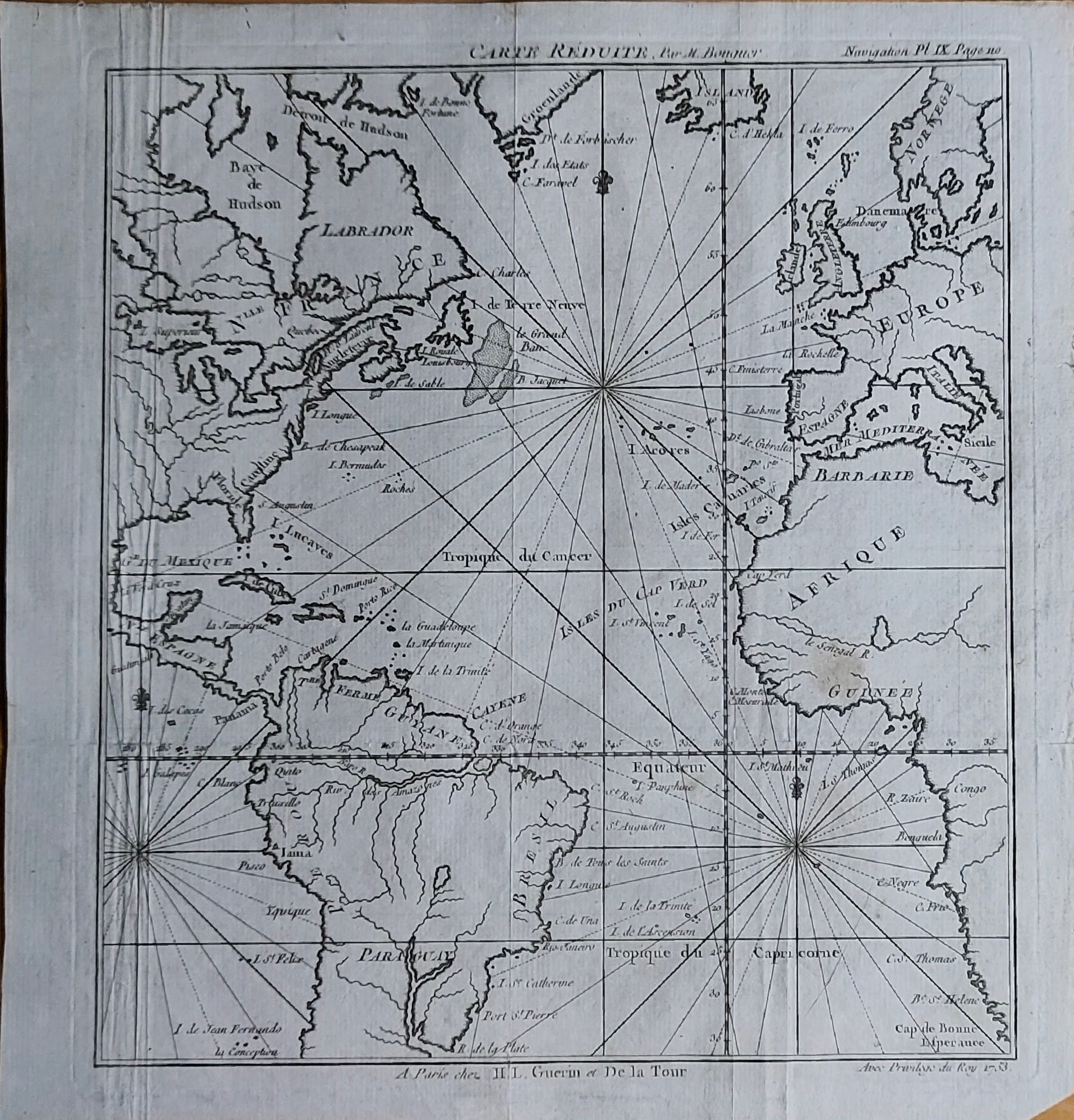
Map title
Carte reduite
Author
Bouguer
Location shown in map
Atlantic
Edition date
1753
Edition place
Paris
Editor
Atlas
Nouveau traité de navigation, contenant la théorie et la pratique du pilotage
Price
150 Euro
State
[mint/EXCELLENT/very good/good/fair/mediocre/poor]
Color
Black/white
Verso
Blank
Size
Plate: cm (21 x 23) inches (8.27 x 9.06) Paper: cm (24 x 26) inches (9.45 x 10.24)
Technique
Copper engraving
Note
Reference
Ex ipso Atlante
Wiki
Here for more info
In stock
Available
Info
info@thetreasuremaps.com
Code
#1356
×
![Carte reduite by Bouguer, Atlantic, 1753]()
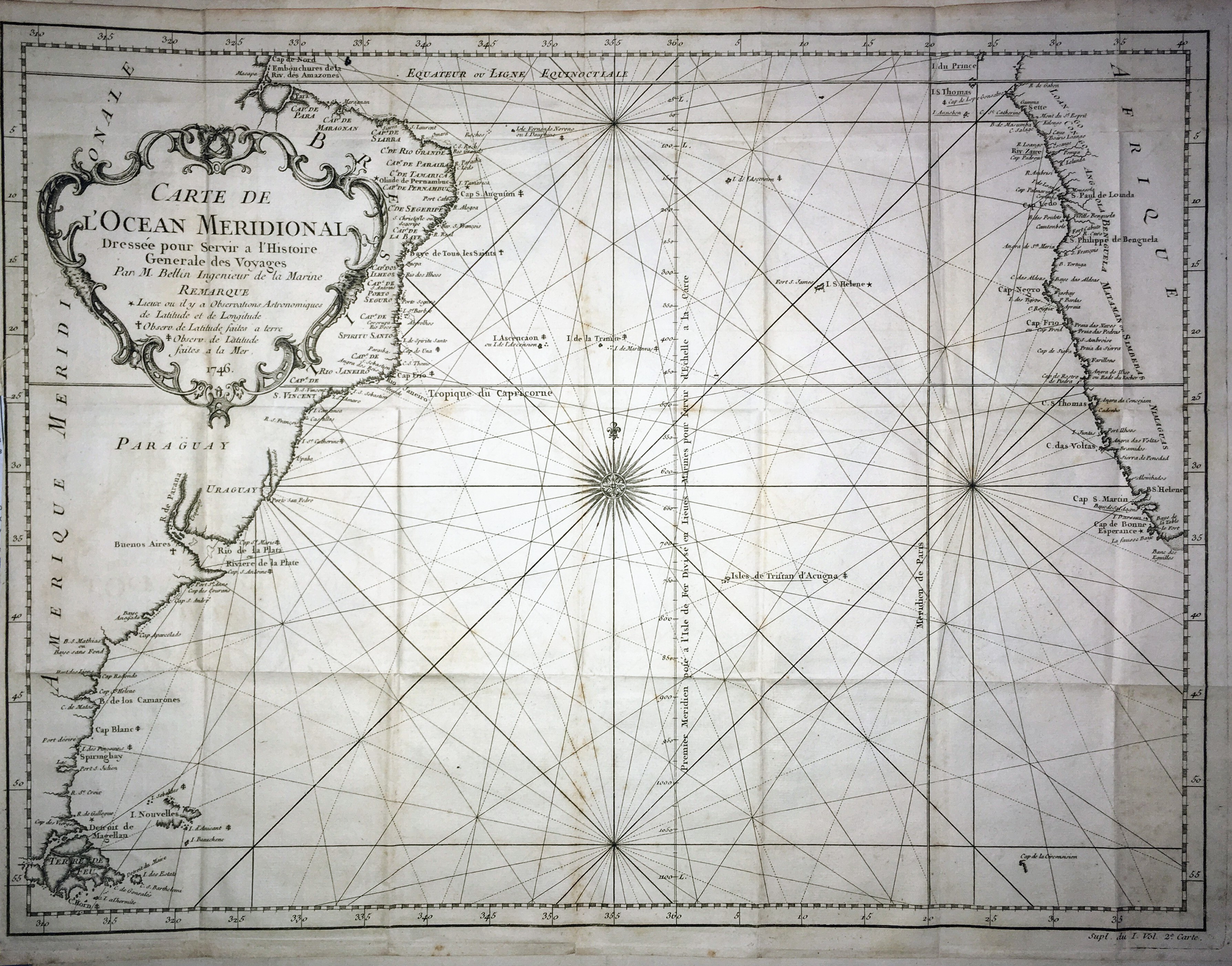
Map title
Carte de l'ocean Meridional
Author
Bellin
Location shown in map
--
Edition date
1757
Edition place
Paris
Editor
--
Atlas
Historie General des Voyages -- Prevost
Price
Please ask: info@thetreasuremaps.com
State
[mint/excellent/VERY GOOD/good/fair/mediocre/poor]
Color
Black/white
Verso
Blank
Size
Plate: cm (45.7 x 34.3) inches (17.99 x 13.5) Paper: cm (50.8 x 36.8) inches (20 x 14.49)
Technique
Copper engraving
Note
No particular notes for this maps
Reference
--
Wiki
Here for more info
In stock
Available
Info
info@thetreasuremaps.com
Code
#0028
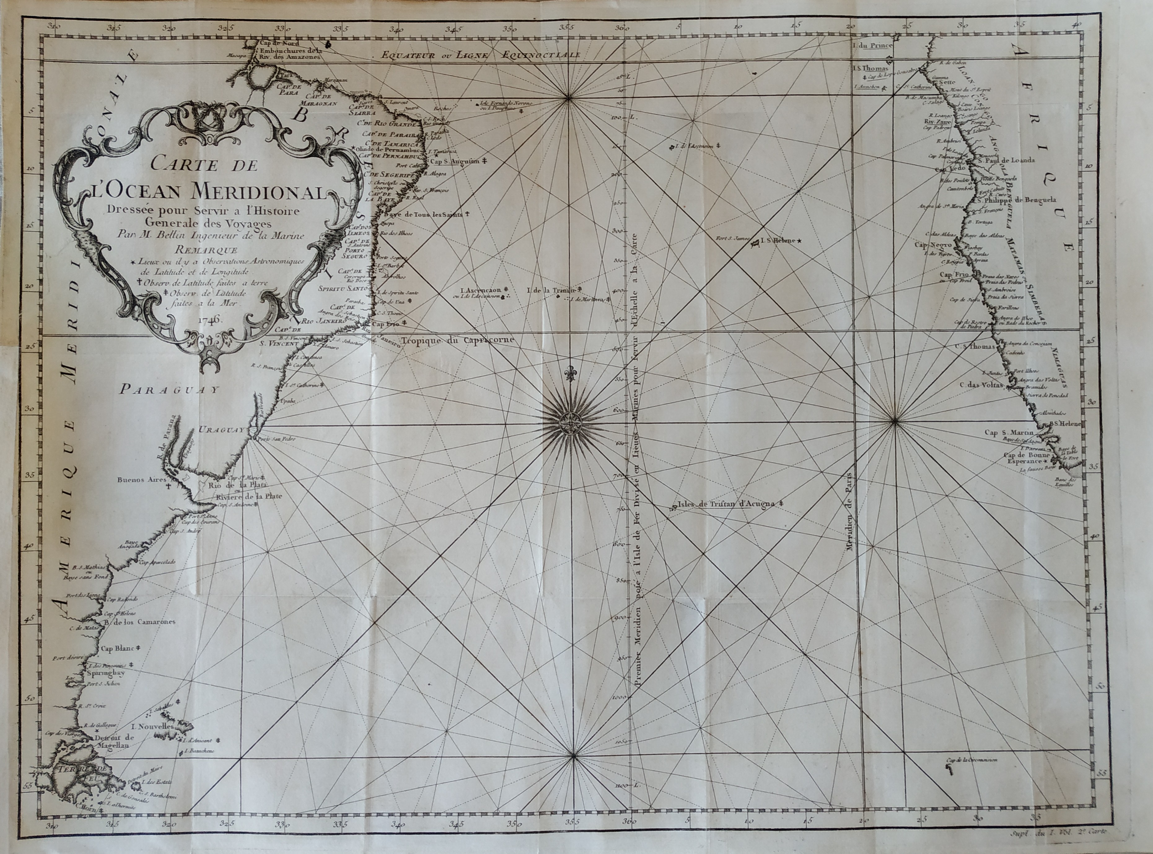
×
![Carte de l'ocean Meridional by Bellin, --, 1757]()
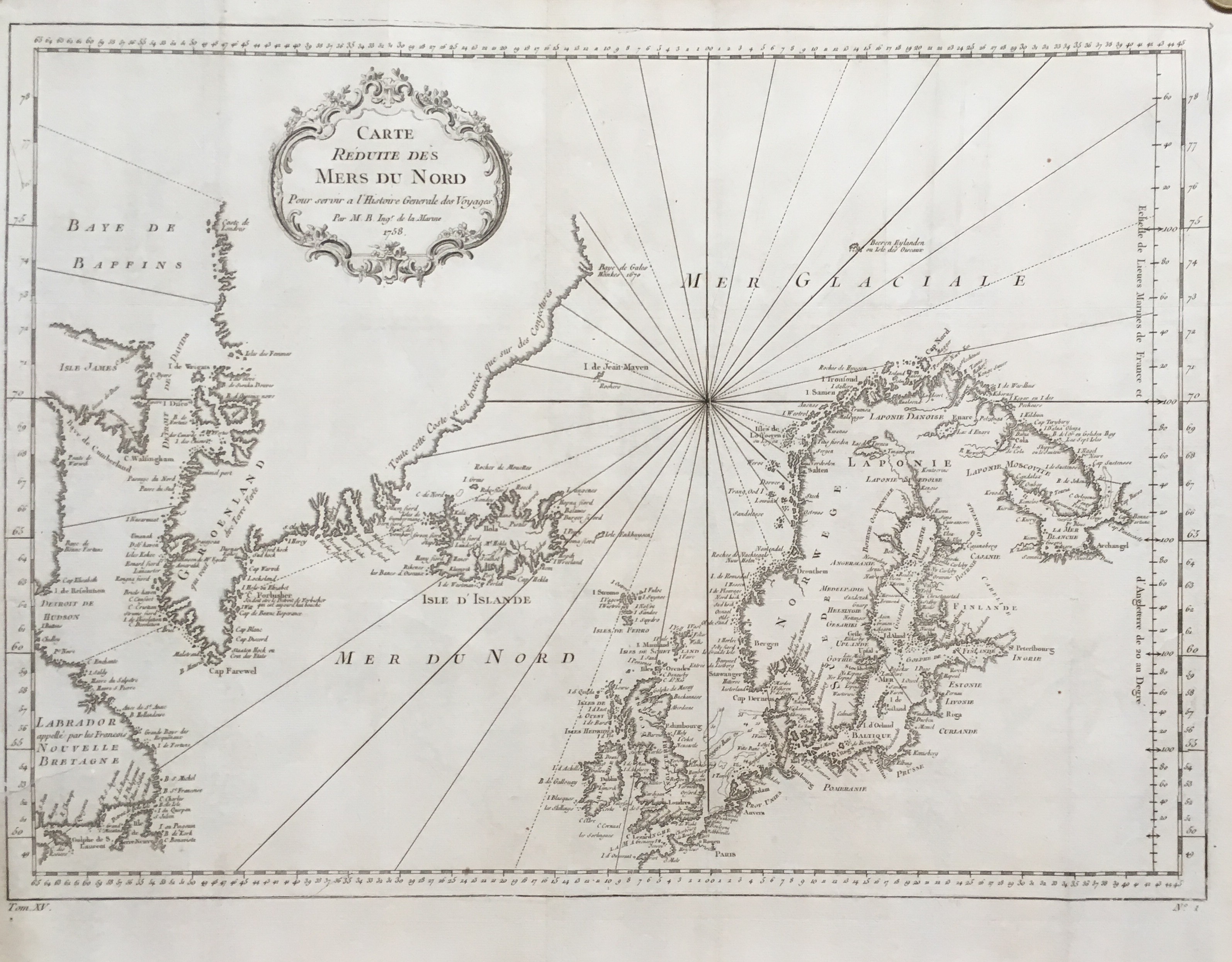
Map title
Carte reduite des mers du nord
Author
Bellin
Location shown in map
North Atlantic
Edition date
1757
Edition place
Paris
Editor
--
Atlas
Historie General des Voyages -- Prevost
Price
250 Euro
State
[mint/excellent/very good/good/fair/MEDIOCRE/poor], the map is damaged
Color
Black/white
Verso
Blank
Size
Plate: cm ( x ) inches (0 x 0) Paper: cm ( x ) inches (0 x 0)
Technique
Copper engraving
Note
No particular notes for this maps
Reference
--
Wiki
Here for more info
In stock
Available
Info
info@thetreasuremaps.com
Code
#0065
×
![Carte reduite des mers du nord by Bellin, North Atlantic, 1757]()
Map title
Carte de l'ocean Occidental
Author
Bellin
Location shown in map
Mid-Atlantic
Edition date
1757
Edition place
Paris
Editor
--
Atlas
Historie General des Voyages -- Prevost
Price
400 Euro
State
[mint/excellent/VERY GOOD/good/fair/mediocre/poor]
Color
Black/white
Verso
Blank
Size
Plate: cm (45.7 x 31.8) inches (17.99 x 12.52) Paper: cm (49.5 x 34.3) inches (19.49 x 13.5)
Technique
Copper engraving
Note
An attractive and desirable 18th-century nautical style map of the Atlantic Ocean, with parts of Western Africa, New England, Europe, and South America. The map boasts a highly decorative cartouche and beautiful compass rose. It is nicely engraved and names dozens of important cities and ports.
Reference
--
Wiki
Here for more info
In stock
Available
Info
info@thetreasuremaps.com
Code
#0066
×
![Carte de l'ocean Occidental by Bellin, Mid-Atlantic, 1757]()
Map title
Carte de l'ocean Oriental ou mer des Indes
Author
Bellin
Location shown in map
--
Edition date
1757
Edition place
Paris
Editor
--
Atlas
Historie General des Voyages -- Prevost
Price
250 Euro
State
[mint/excellent/very good/good/FAIR/mediocre/poor] The map has been repaired. The upper left corner was cut off.
Color
Black/white
Verso
Blank
Size
Plate: cm (48.3 x 34.3) inches (19.02 x 13.5) Paper: cm (49.5 x 35.6) inches (19.49 x 14.02)
Technique
Copper engraving
Note
Large maritime map of the Indian Ocean. Coastal data is shown on the land masses of Africa, Arabian Peninsula, India, Indonesia and part of Australia.
Reference
--
Wiki
Here for more info
In stock
Available
Info
info@thetreasuremaps.com
Code
#0248
×
![Carte de l'ocean Oriental ou mer des Indes by Bellin, --, 1757]()
Map title
Carte reduite de la Mer Du Sud
Author
Bellin
Location shown in map
South Pacific
Edition date
1757
Edition place
Paris
Editor
--
Atlas
Historie General des Voyages -- Prevost
Price
300 Euro
State
[mint/excellent/VERY GOOD/good/fair/mediocre/poor]
Color
Black/white
Verso
Blank
Size
Plate: cm (34.3 x 21.6) inches (13.5 x 8.5) Paper: cm (34.3 x 21.6) inches (13.5 x 8.5)
Technique
Copper engraving
Note
Showing recent discoveries in the South Pacific: Australia's eastern coastline is virtually featureless, running from New Guinea to Tasmania without a break. Only a small section of New Zealand is marked.
Reference
--
Wiki
Here for more info
In stock
Available
Info
info@thetreasuremaps.com
Code
#0403
×
![Carte reduite de la Mer Du Sud by Bellin, South Pacific, 1757]()
Map title
Carte reduite de la mer du Sud
Author
Bellin
Location shown in map
South Pacific
Edition date
1757
Edition place
Paris
Editor
--
Atlas
Historie General des Voyages -- Prevost
Price
300 Euro
State
[mint/EXCELLENT/very good/good/fair/mediocre/poor]
Color
Modern color
Verso
Blank
Size
Plate: cm (35.5 x 21) inches (13.98 x 8.27) Paper: cm (39 x 23) inches (15.35 x 9.06)
Technique
Copper engraving
Note
Showing recent discoveries in the South Pacific: Australia's eastern coastline is virtually featureless, running from New Guinea to Tasmania without a break. Only a small section of New Zealand is marked.
Reference
--
Wiki
Here for more info
In stock
Available
Info
info@thetreasuremaps.com
Code
#0806
×
![Carte reduite de la mer du Sud by Bellin, South Pacific, 1757]()
Map title
Mapa de la Parte del Norte Del Mar Del Sur
Author
Pedro de Gongora
Location shown in map
North Pacific
Edition date
1788
Edition place
Madrid
Editor
D. Antonio de Sancha
Atlas
Price
200 Euro
State
[mint/EXCELLENT/very good/good/fair/mediocre/poor]
Color
Black/white
Verso
Blank
Size
Plate: cm (34 x 24) inches (13.39 x 9.45) Paper: cm (36 x 29) inches (14.17 x 11.42)
Technique
Copper engraving
Note
Reference
--
Wiki
Here for more info
In stock
Available
Info
info@thetreasuremaps.com
Code
#1001
×
![Mapa de la Parte del Norte Del Mar Del Sur by Pedro de Gongora, North Pacific, 1788]()