South America
Map title
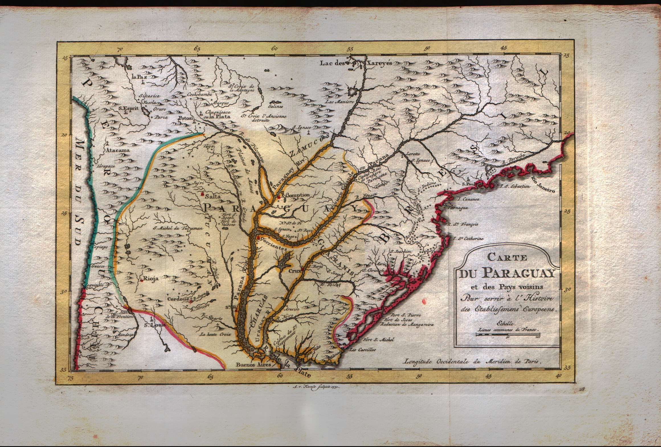
Carte du Paraguay et des pays voisins
Author
Bellin
Location shown in map
--
Edition date
1773
Edition place
Amsterdam
Editor
--
Atlas
Atlas Portatif -- E. van Harrevelt
Price
Please ask: info@thetreasuremaps.com
State
[mint/EXCELLENT/very good/good/fair/mediocre/poor]
Color
Old colors
Verso
Blank
Size
Plate: cm (30.5 x 20.3) inches (12.01 x 7.99) Paper: cm (39.4 x 26.7) inches (15.51 x 10.51)
Technique
Copper engraving
Note
No particular notes for this maps
Reference
--
Wiki
Here for more info
In stock
Available
Info
info@thetreasuremaps.com
Code
#0042
×
![Carte du Paraguay et des pays voisins by Bellin, --, 1773]()
Map title
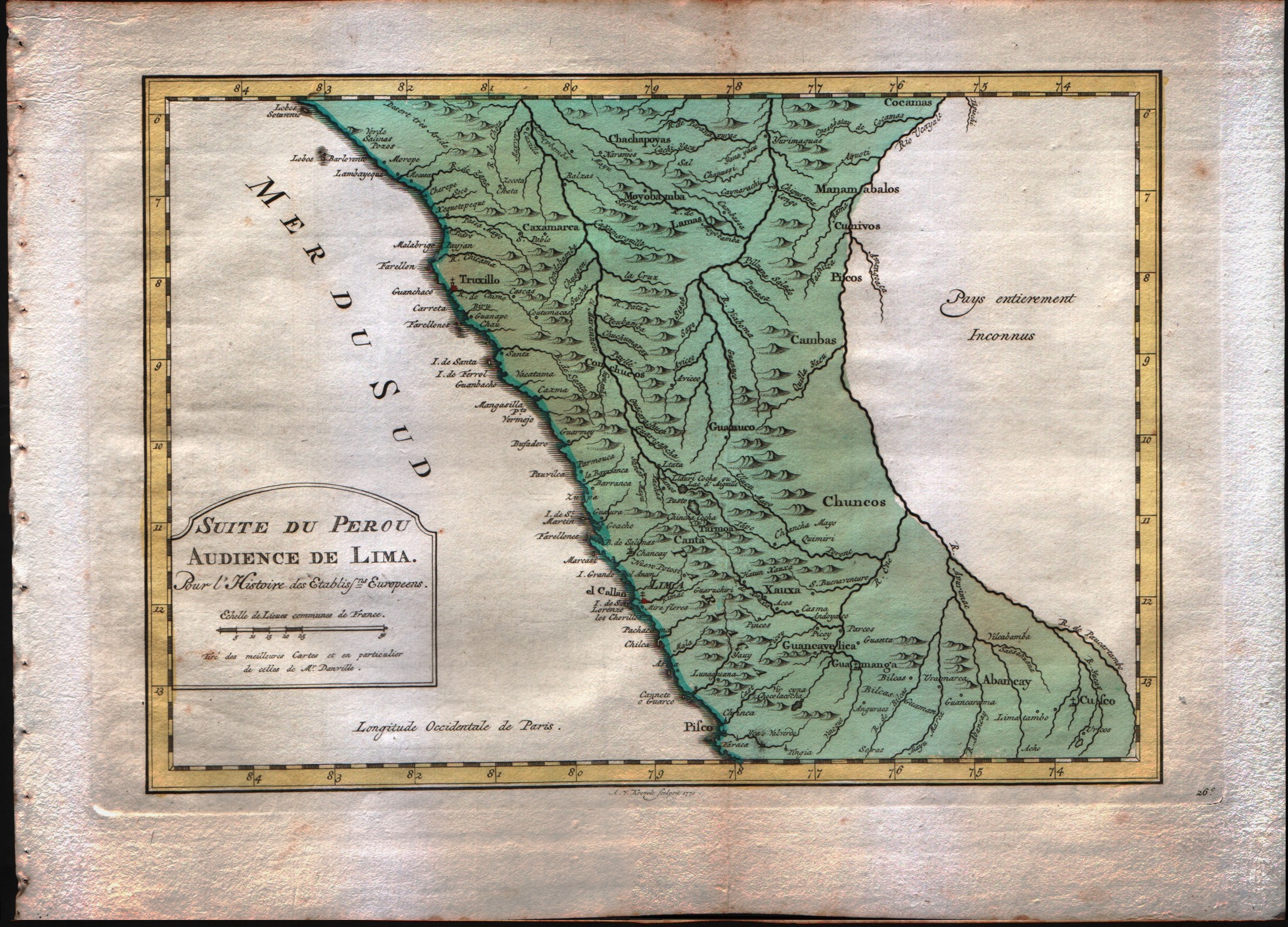
Suit du Perou audience de Lima
Author
Bellin
Location shown in map
Peru
Edition date
1773
Edition place
Amsterdam
Editor
--
Atlas
Atlas Portatif -- E. van Harrevelt
Price
Please ask: info@thetreasuremaps.com
State
[mint/EXCELLENT/very good/good/fair/mediocre/poor]
Color
Old colors
Verso
Blank
Size
Plate: cm (29.2 x 20.3) inches (11.5 x 7.99) Paper: cm (36.8 x 26.7) inches (14.49 x 10.51)
Technique
Copper engraving
Note
No particular notes for this maps
Reference
--
Wiki
Here for more info
In stock
Available
Info
info@thetreasuremaps.com
Code
#0041
×
![Suit du Perou audience de Lima by Bellin, Peru, 1773]()
Map title
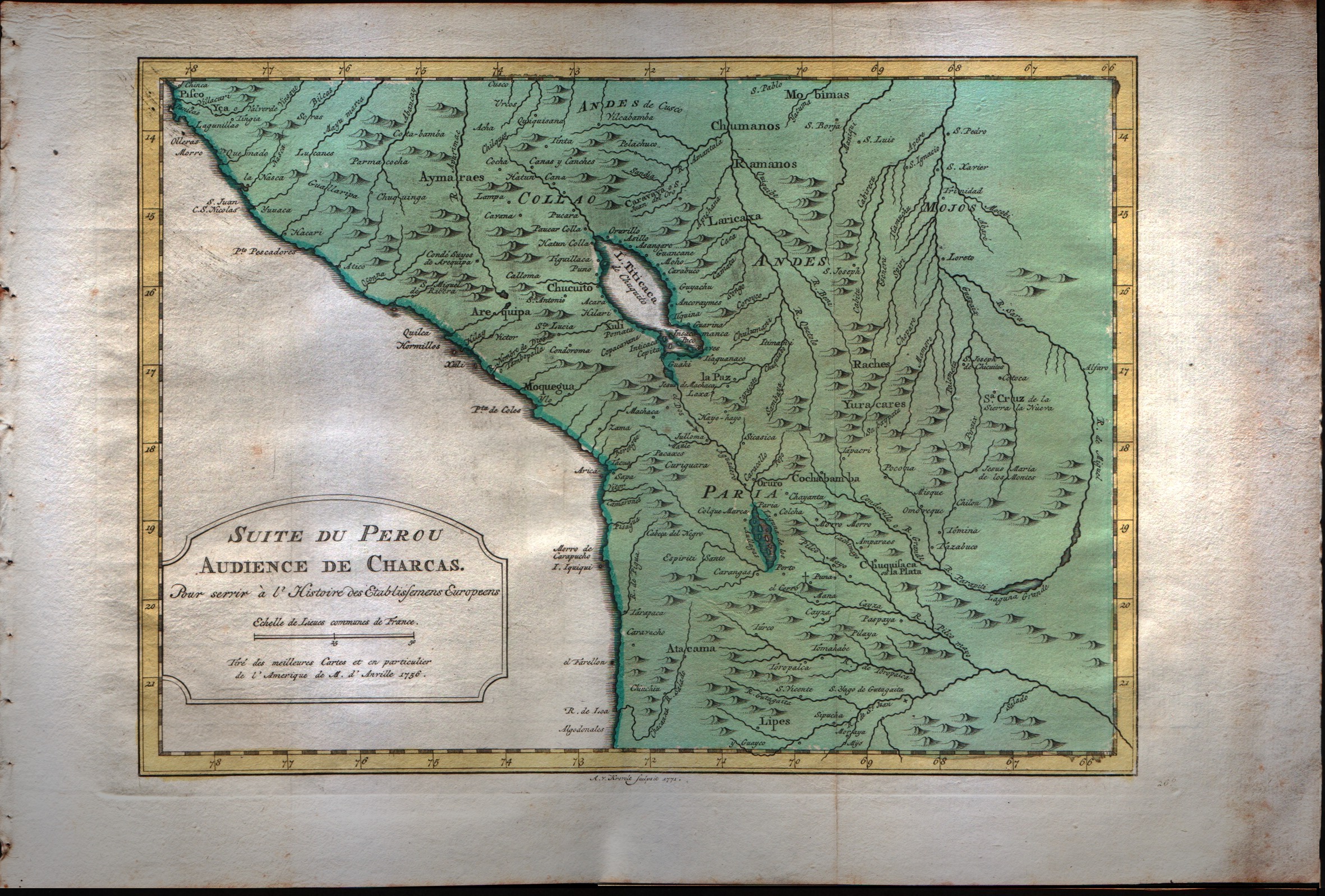
Suit du Perou audience de Charcas
Author
Bellin
Location shown in map
Peru
Edition date
1773
Edition place
Amsterdam
Editor
--
Atlas
Atlas Portatif -- E. van Harrevelt
Price
Please ask: info@thetreasuremaps.com
State
[mint/EXCELLENT/very good/good/fair/mediocre/poor]
Color
Old colors
Verso
Blank
Size
Plate: cm (30.5 x 21.6) inches (12.01 x 8.5) Paper: cm (38.1 x 26.7) inches (15 x 10.51)
Technique
Copper engraving
Note
No particular notes for this maps
Reference
--
Wiki
Here for more info
In stock
Available
Info
info@thetreasuremaps.com
Code
#0040
×
![Suit du Perou audience de Charcas by Bellin, Peru, 1773]()

Map title
Carte du Chili depuis le sud du Perou jusqu'au cap Horn
Author
Bonne
Location shown in map
--
Edition date
1787
Edition place
Paris
Editor
--
Atlas
Atlas Encyclopedique
Price
Please ask: info@thetreasuremaps.com
State
[mint/excellent/very good/GOOD/fair/mediocre/poor]
Color
Modern outlined
Verso
Blank
Size
Plate: cm (31.8 x 21) inches (12.52 x 8.27) Paper: cm (31.8 x 21) inches (12.52 x 8.27)
Technique
Copper engraving
Note
No particular notes for this maps
Reference
--
Wiki
Here for more info
In stock
Sold
Info
info@thetreasuremaps.com
Code
#0461
×
![Carte du Chili depuis le sud du Perou jusqu'au cap Horn by Bonne, --, 1787]()
Map title
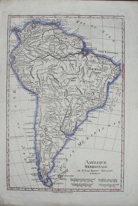
Amerique Meridionale
Author
Bonne
Location shown in map
South America
Edition date
1787
Edition place
Paris
Editor
--
Atlas
Atlas Encyclopedique
Price
Please ask: info@thetreasuremaps.com
State
[mint/excellent/very good/GOOD/fair/mediocre/poor]
Color
Modern outlined
Verso
Blank
Size
Plate: cm (31.8 x 21) inches (12.52 x 8.27) Paper: cm (31.8 x 21) inches (12.52 x 8.27)
Technique
Copper engraving
Note
No particular notes for this maps
Reference
--
Wiki
Here for more info
In stock
Sold
Info
info@thetreasuremaps.com
Code
#0399
×
![Amerique Meridionale by Bonne, South America, 1787]()
Map title
America Meridionale
Author
Sanson
Location shown in map
South America
Edition date
Circa 1790
Edition place
Editor
--
Atlas
Geographie universelle, italian edition.
Price
125 Euro
State
[mint/EXCELLENT/very good/good/fair/mediocre/poor]
Color
Black/white
Verso
Blank
Size
Plate: cm (18 x 21) inches (7.09 x 8.27) Paper: cm (20 x 24) inches (7.87 x 9.45)
Technique
Copper engraving
Note
Claude Buffier was a Jesuit theologian and geographer working in Paris, who wrote the Geographie Universelle, first issued in about 1715. The Geographie was issued as a pocket-sized volume, illustrated with a set of maps.The volume proved very popular, and numerous editions were published in Paris, Naples and Rome. The book was evidently targeted at the popular market, and for this reason examples of the book tend to be printed on relatively poor quality paper, and this is particularly true of the Italian editions.Evidently there were a large number of different sets of map plates used - so far 17 different plates or states of plates have been identified for the Americas map, some engraved anonymously, and other signed by Hendrick van Loon, Faure, Denise Macquart and Dom. Dell'Acerra Unfortunately, it has been frequent practice to disperse such volumes, so the origin of several of these plates has not yet been identified, and the editor would be grateful to hear from readers about editions of the book, particularly those containing maps engraved by Denise Macquart and Dom. Dell'Acerra.
Reference
--
Wiki
Here for more info
In stock
Available
Info
info@thetreasuremaps.com
Code
#0942
×
![America Meridionale by Sanson, South America, Circa 1790]()
Map title
Partie septentrionale du Perou
Author
Bellin
Location shown in map
--
Edition date
1813
Edition place
Paris
Editor
--
Atlas
Nouvel Atlas Portatif
Price
Please ask: info@thetreasuremaps.com
State
[mint/excellent/very good/GOOD/fair/mediocre/poor]
Color
Old outlined
Verso
Blank
Size
Plate: cm (19 x 16.5) inches (7.48 x 6.5) Paper: cm (22.9 x 20.3) inches (9.02 x 7.99)
Technique
--
Note
No particular notes for this maps
Reference
--
Wiki
Here for more info
In stock
Available
Info
info@thetreasuremaps.com
Code
#0051
×
![Partie septentrionale du Perou by Bellin, --, 1813]()
Map title
Amerique Meridionale
Author
Monin
Location shown in map
South America
Edition date
1840
Edition place
Paris
Editor
Atlas
Atlas Classique de la Geographie
Price
50 Euro
State
[mint/EXCELLENT/very good/good/fair/mediocre/poor]
Color
Old colors
Verso
Blank
Size
Plate: cm (27 x 37) inches (10.63 x 14.57) Paper: cm (33 x 45) inches (12.99 x 17.72)
Technique
Copper engraving
Note
Reference
Wiki
Here for more info
In stock
Available
Info
info@thetreasuremaps.com
Code
#1011
×
![Amerique Meridionale by Monin, South America, 1840]()
Map title
Carte de l'Amerique Meridionale
Author
Barbie
Location shown in map
South America
Edition date
Circa 1852
Edition place
Paris
Editor
Atlas
Price
50 Euro
State
[mint/excellent/VERY GOOD/good/fair/mediocre/poor]
Color
Old colors
Verso
Blank
Size
Plate: cm (23 x 30) inches (9.06 x 11.81) Paper: cm (25 x 35) inches (9.84 x 13.78)
Technique
Copper engraving
Note
Reference
Wiki
Here for more info
In stock
Available
Info
info@thetreasuremaps.com
Code
#1040
×
![Carte de l'Amerique Meridionale by Barbie, South America, Circa 1852]()
Map title
Amerique meridionale
Author
Location shown in map
South America
Edition date
Circa 1860
Edition place
Paris
Editor
Poussielgue
Atlas
Price
20 Euro
State
[mint/EXCELLENT/very good/good/fair/mediocre/poor]
Color
Old colors
Verso
Blank
Size
Plate: cm (27 x 34) inches (10.63 x 13.39) Paper: cm (31 x 44) inches (12.2 x 17.32)
Technique
Steel engraving
Note
Patagonia is indipendent
Reference
Wiki
Here for more info
In stock
Available
Info
info@thetreasuremaps.com
Code
#1367
×
![Amerique meridionale by , South America, Circa 1860]()