South East

Map title
--
Author
Bordone
Location shown in map
Java
Edition date
1534
Edition place
Venice
Editor
Federico Torresano
Atlas
Isolario
Price
Please ask: info@thetreasuremaps.com
State
[mint/EXCELLENT/very good/good/fair/mediocre/poor]
Color
Black/white
Verso
Italian text pag.69
Size
Plate: cm (14 x 8.9) inches (5.51 x 3.5) Paper: cm (20.3 x 27.9) inches (7.99 x 10.98)
Technique
Woodcut
Note
No particular notes for this maps.
Reference
--
Wiki
Here for more info
In stock
Sold
Info
info@thetreasuremaps.com
Code
#0667
--
Author
Bordone
Location shown in map
Java
Edition date
1534
Edition place
Venice
Editor
Federico Torresano
Atlas
Isolario
Price
Please ask: info@thetreasuremaps.com
State
[mint/EXCELLENT/very good/good/fair/mediocre/poor]
Color
Black/white
Verso
Italian text pag.69
Size
Plate: cm (14 x 8.9) inches (5.51 x 3.5) Paper: cm (20.3 x 27.9) inches (7.99 x 10.98)
Technique
Woodcut
Note
No particular notes for this maps.
Reference
--
Wiki
Here for more info
In stock
Sold
Info
info@thetreasuremaps.com
Code
#0667
×
![-- by Bordone, Java, 1534]()

Map title
--
Author
Bordone
Location shown in map
Necumera Locaz Patera Botegon Mangama
Edition date
1534
Edition place
Venice
Editor
Federico Torresano
Atlas
Isolario
Price
Please ask: info@thetreasuremaps.com
State
[mint/EXCELLENT/very good/good/fair/mediocre/poor]
Color
Black/white
Verso
Italian text pag.69
Size
Plate: cm (14 x 8) inches (5.51 x 3.15) Paper: cm (20.3 x 29) inches (7.99 x 11.42)
Technique
Woodcut
Note
Locaz or Lochac could be Thailand rendered as an island.
Reference
--
Wiki
Here for more info
In stock
Sold
Info
info@thetreasuremaps.com
Code
#0668
--
Author
Bordone
Location shown in map
Necumera Locaz Patera Botegon Mangama
Edition date
1534
Edition place
Venice
Editor
Federico Torresano
Atlas
Isolario
Price
Please ask: info@thetreasuremaps.com
State
[mint/EXCELLENT/very good/good/fair/mediocre/poor]
Color
Black/white
Verso
Italian text pag.69
Size
Plate: cm (14 x 8) inches (5.51 x 3.15) Paper: cm (20.3 x 29) inches (7.99 x 11.42)
Technique
Woodcut
Note
Locaz or Lochac could be Thailand rendered as an island.
Reference
--
Wiki
Here for more info
In stock
Sold
Info
info@thetreasuremaps.com
Code
#0668
×
![-- by Bordone, Necumera Locaz Patera Botegon Mangama, 1534]()
Map title
India orientalis
Author
Fries
Location shown in map
Southeast Asia
Edition date
1535
Edition place
Lyon
Editor
Melchior and Gaspar Trechsel
Atlas
Ptolemy's Geographia
Price
2000 Euro
State
[mint/EXCELLENT/very good/good/fair/mediocre/poor] repaired
Color
Black/white
Verso
Blank
Size
Plate: cm (41.9 x 30.5) inches (16.5 x 12.01) Paper: cm (55.9 x 40.6) inches (22.01 x 15.98)
Technique
Woodcut
Note
--
Reference
--
Wiki
Here for more info
In stock
Available
Info
info@thetreasuremaps.com
Code
#0173
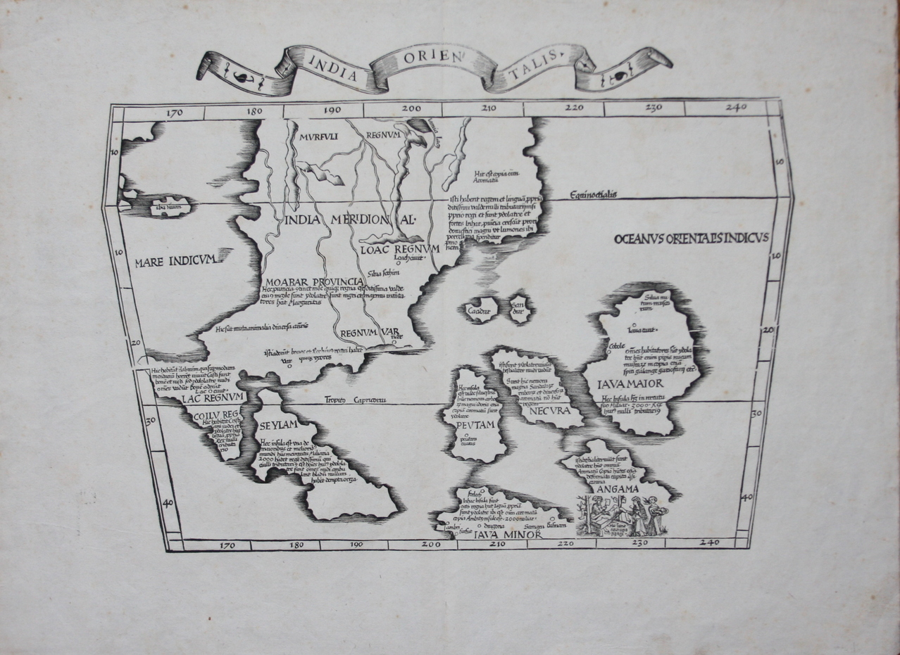
×
![India orientalis by Fries, Southeast Asia, 1535]()
Map title
India orientalis
Author
Fries
Location shown in map
Southeast Asia
Edition date
1541
Edition place
Vienne
Editor
Trechsel, Gaspar
Atlas
Claudii Ptolemaei Alexandrini Geographicae Enarrationis
Price
1200 Euro
State
[mint/excellent/VERY GOOD/good/fair/mediocre/poor]
Color
Black/white
Verso
Blank
Size
Plate: cm (53 x 40) inches (20.87 x 15.75) Paper: cm (53 x 40) inches (20.87 x 15.75)
Technique
Woodcut
Note
Professionaly restored
Reference
--
Wiki
Here for more info
In stock
Available
Info
info@thetreasuremaps.com
Code
#1259
×
![India orientalis by Fries, Southeast Asia, 1541]()
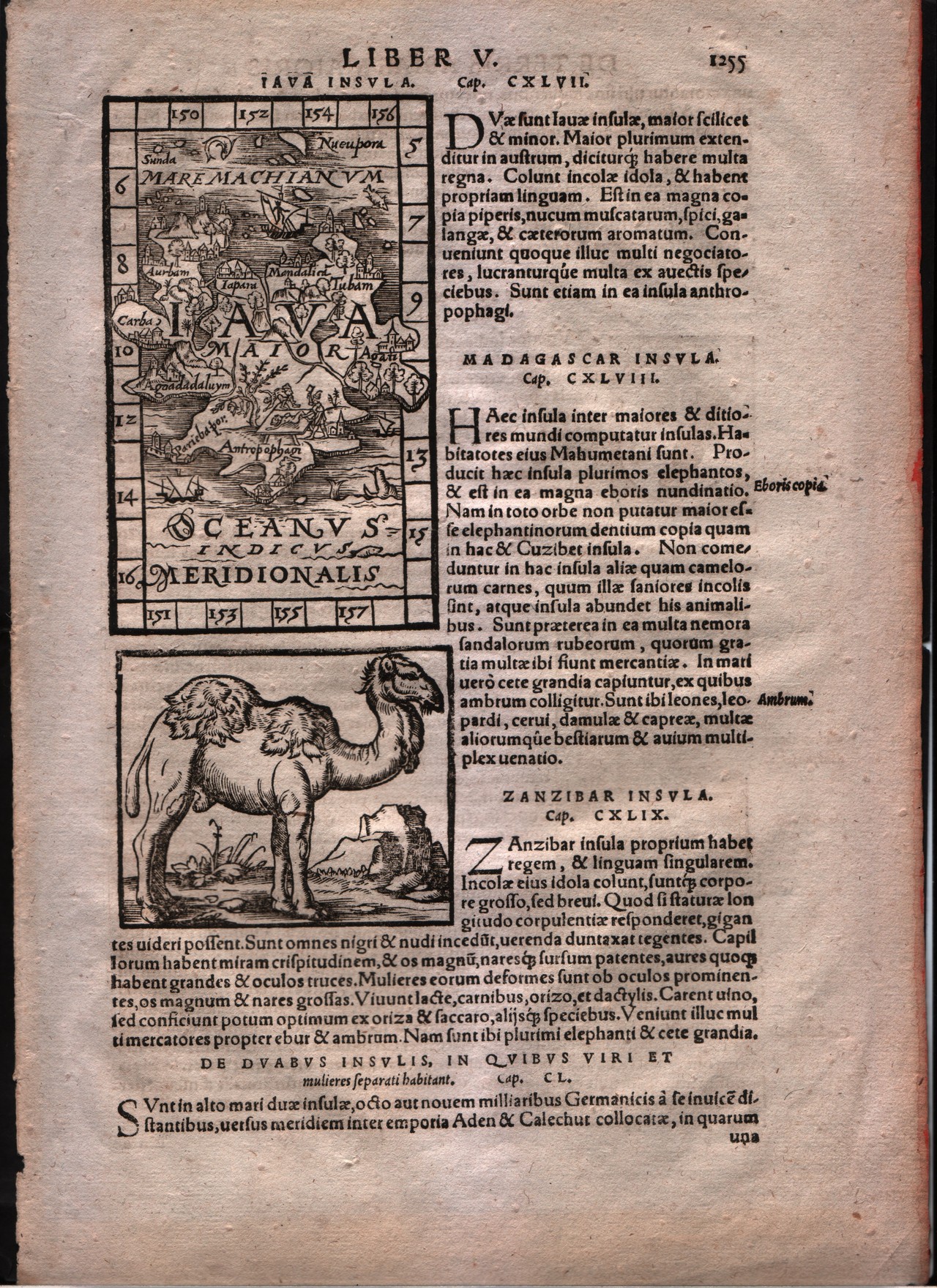
Map title
Iava insula
Author
Honter
Location shown in map
Java
Edition date
1561
Edition place
Basle
Editor
--
Atlas
Cosmographiae Rudimentis -- Johannes Honter
Price
Please ask: info@thetreasuremaps.com
State
[mint/EXCELLENT/very good/good/fair/mediocre/poor]
Color
Black/white
Verso
Latin text pag.1255
Size
Plate: cm (7.6 x 12.7) inches (2.99 x 5) Paper: cm (21.6 x 31.8) inches (8.5 x 12.52)
Technique
Woodcut
Note
--
Reference
--
Wiki
Here for more info
In stock
Sold
Info
info@thetreasuremaps.com
Code
#0180
×
![Iava insula by Honter, Java, 1561]()
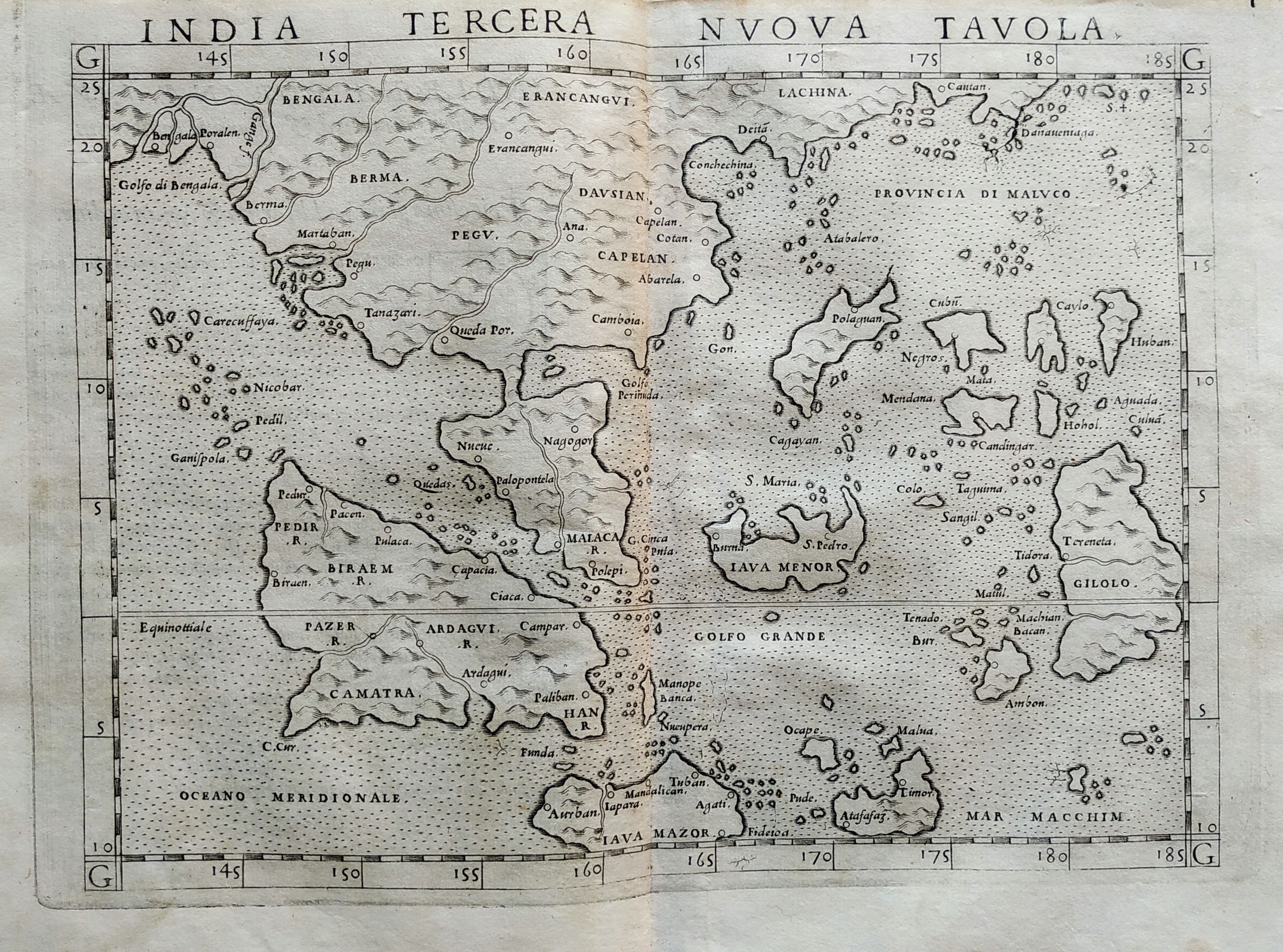
Map title
India tercera nova tabula
Author
Ruscelli
Location shown in map
Southeast Asia
Edition date
1561
Edition place
Venice
Editor
Vincenzo Valgrisi
Atlas
La Geographia di Claudio Tolomeo
Price
500 Euro
State
[mint/EXCELLENT/very good/good/fair/mediocre/poor]
Color
Black/white
Verso
Size
Plate: cm (26 x 19) inches (10.24 x 7.48) Paper: cm (27.9 x 20.3) inches (10.98 x 7.99)
Technique
Copper engraving
Note
No particular notes for this maps.
Reference
--
Wiki
Here for more info
In stock
Available
Info
info@thetreasuremaps.com
Code
#0768
×
![India tercera nova tabula by Ruscelli, Southeast Asia, 1561]()
Map title
India tercera nova tabula
Author
Ruscelli
Location shown in map
Southeast Asia
Edition date
1574
Edition place
Venice
Editor
Giordano Ziletti
Atlas
La Geographia di Claudio Tolomeo
Price
500 Euro
State
[mint/excellent/VERY GOOD/good/fair/mediocre/poor]
Color
Black/white
Verso
Italian text pag.30
Size
Plate: cm (25.4 x 19) inches (10 x 7.48) Paper: cm (30.5 x 22.9) inches (12.01 x 9.02)
Technique
Copper engraving
Note
India shown.
Reference
Genoa pubblic library "Civica Berio"
Wiki
Here for more info
In stock
Available
Info
info@thetreasuremaps.com
Code
#0182
×
![India tercera nova tabula by Ruscelli, Southeast Asia, 1574]()
Map title
Descrittione dell'isole Molucche
Author
Porcacchi
Location shown in map
Southest Asia
Edition date
1576
Edition place
Venice
Editor
--
Atlas
L'Isole piu famose del mondo -- S. Galignani and G. Porro
Price
400 Euro
State
[MINT/excellent/very good/good/fair/mediocre/poor]
Color
Black/white
Verso
Italian text pag.190
Size
Plate: cm (15.2 x 11.4) inches (5.98 x 4.49) Paper: cm (19 x 27.9) inches (7.48 x 10.98)
Technique
Copper engraving
Note
Reference
Genoa pubblic library "Civica Berio"
Wiki
Here for more info
In stock
Available
Info
info@thetreasuremaps.com
Code
#1077
×
![Descrittione dell'isole Molucche by Porcacchi, Southest Asia, 1576]()
Map title
Descrittione dell'isole Molucche
Author
Porcacchi
Location shown in map
Southest Asia
Edition date
1576
Edition place
Venice
Editor
--
Atlas
L'Isole piu famose del mondo -- S. Galignani and G. Porro
Price
Please ask: info@thetreasuremaps.com
State
[MINT/excellent/very good/good/fair/mediocre/poor]
Color
Black/white
Verso
Italian text pag.190
Size
Plate: cm (15.2 x 11.4) inches (5.98 x 4.49) Paper: cm (19 x 27.9) inches (7.48 x 10.98)
Technique
Copper engraving
Note
No particular notes for this maps
Reference
Genoa pubblic library "Civica Berio"
Wiki
Here for more info
In stock
Available
Info
info@thetreasuremaps.com
Code
#0196
×
![Descrittione dell'isole Molucche by Porcacchi, Southest Asia, 1576]()

Map title
Sumatra
Author
Munster
Location shown in map
Sumatra
Edition date
1598
Edition place
Basel
Editor
Henrich Petri
Atlas
Cosmographia Universalis
Price
300 Euro
State
[mint/excellent/VERY GOOD/good/fair/mediocre/poor]
Color
Black/white
Verso
German text
Size
Plate: cm (36 x 31) inches (14.17 x 12.2) Paper: cm (32 x 39) inches (12.6 x 15.35)
Technique
Woodcut
Note
Reference
--
Wiki
Here for more info
In stock
Available
Info
info@thetreasuremaps.com
Code
#1350
Sumatra
Author
Munster
Location shown in map
Sumatra
Edition date
1598
Edition place
Basel
Editor
Henrich Petri
Atlas
Cosmographia Universalis
Price
300 Euro
State
[mint/excellent/VERY GOOD/good/fair/mediocre/poor]
Color
Black/white
Verso
German text
Size
Plate: cm (36 x 31) inches (14.17 x 12.2) Paper: cm (32 x 39) inches (12.6 x 15.35)
Technique
Woodcut
Note
Reference
--
Wiki
Here for more info
In stock
Available
Info
info@thetreasuremaps.com
Code
#1350
×
![Sumatra by Munster, Sumatra, 1598]()
Map title
Sumatra
Author
Munster
Location shown in map
Sumatra
Edition date
1598
Edition place
Basel
Editor
Henrich Petri
Atlas
Cosmographia Universalis
Price
400 Euro
State
[mint/excellent/VERY GOOD/good/fair/mediocre/poor]
Color
Black/white
Verso
German text
Size
Plate: cm (57 x 47) inches (22.44 x 18.5) Paper: cm (66 x 55) inches (25.98 x 21.65)
Technique
Woodcut
Note
No particular notes for this maps
Reference
--
Wiki
Here for more info
In stock
Available
Info
info@thetreasuremaps.com
Code
#0733
Sumatra
Author
Munster
Location shown in map
Sumatra
Edition date
1598
Edition place
Basel
Editor
Henrich Petri
Atlas
Cosmographia Universalis
Price
400 Euro
State
[mint/excellent/VERY GOOD/good/fair/mediocre/poor]
Color
Black/white
Verso
German text
Size
Plate: cm (57 x 47) inches (22.44 x 18.5) Paper: cm (66 x 55) inches (25.98 x 21.65)
Technique
Woodcut
Note
No particular notes for this maps
Reference
--
Wiki
Here for more info
In stock
Available
Info
info@thetreasuremaps.com
Code
#0733
×
![Sumatra by Munster, Sumatra, 1598]()
Map title
India orientalis
Author
Magini
Location shown in map
Southest Asia
Edition date
1598
Edition place
Venice
Editor
Battista & Giorgio Galignani
Atlas
Geografia di Claudio Tolomeo -- Giovanni Antonio Magini
Price
350 Euro
State
[MINT/excellent/very good/good/fair/mediocre/poor]
Color
Black/white
Verso
Italian text pag.183
Size
Plate: cm (12.7 x 17.8) inches (5 x 7.01) Paper: cm (20.3 x 30.5) inches (7.99 x 12.01)
Technique
Copper engraving
Note
The Far East.
Reference
--
Wiki
Here for more info
In stock
Available
Info
info@thetreasuremaps.com
Code
#0211
×
![India orientalis by Magini, Southest Asia, 1598]()
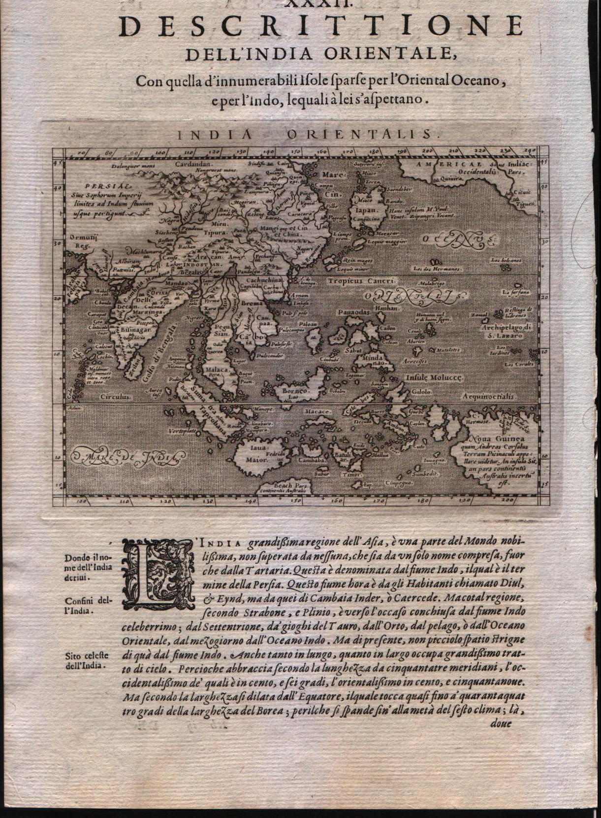
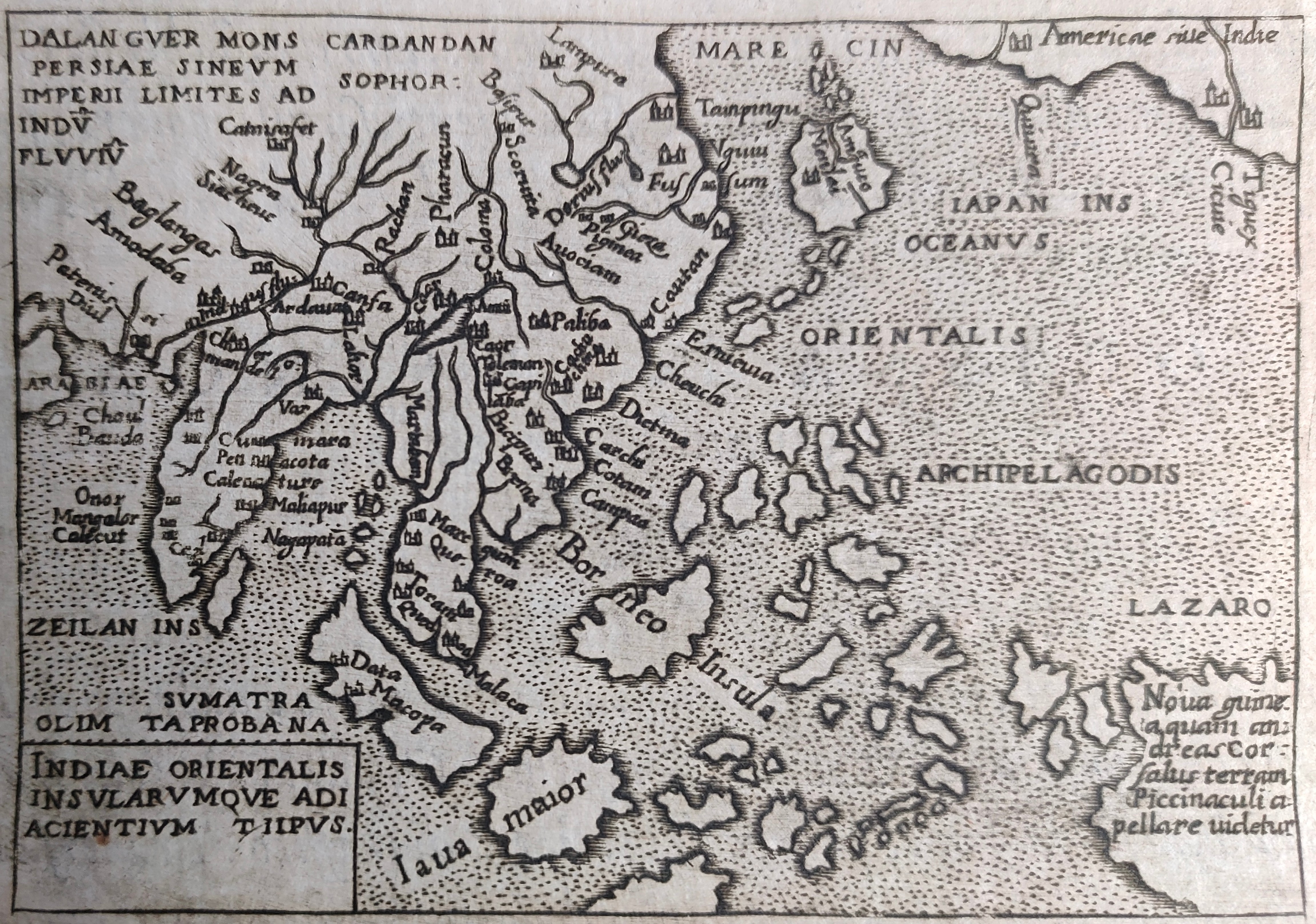
Map title
Indiae orientalis insularumque adiacientium typus
Author
Ortelius
Location shown in map
Southeast Asia
Edition date
1598
Edition place
Brescia
Editor
--
Atlas
Theatro del mondo -- Compania Bresciana
Price
200 Euro
State
[mint/EXCELLENT/very good/good/fair/mediocre/poor]
Color
Black/white
Verso
Italian text pag.199
Size
Plate: cm (11 x 8) inches (4.33 x 3.15) Paper: cm (14 x 19) inches (5.51 x 7.48)
Technique
Copper engraving
Note
No particular notes for this maps.
Reference
--
Wiki
Here for more info
In stock
Available
Info
info@thetreasuremaps.com
Code
#0199
×
![Indiae orientalis insularumque adiacientium typus by Ortelius, Southeast Asia, 1598]()
Map title
Indiae orientalis
Author
Ortelius
Location shown in map
Southeast Asia
Edition date
1598
Edition place
Brescia
Editor
Pietro Marchetti
Atlas
Theatro del mondo
Price
150 Euro
State
[mint/EXCELLENT/very good/good/fair/mediocre/poor]
Color
Black/white
Verso
Italian text
Size
Plate: cm (11 x 8) inches (4.33 x 3.15) Paper: cm (11 x 8) inches (4.33 x 3.15)
Technique
Copper engraving
Note
Reference
Wiki
Here for more info
In stock
Available
Info
info@thetreasuremaps.com
Code
#0861
×
![Indiae orientalis by Ortelius, Southeast Asia, 1598]()
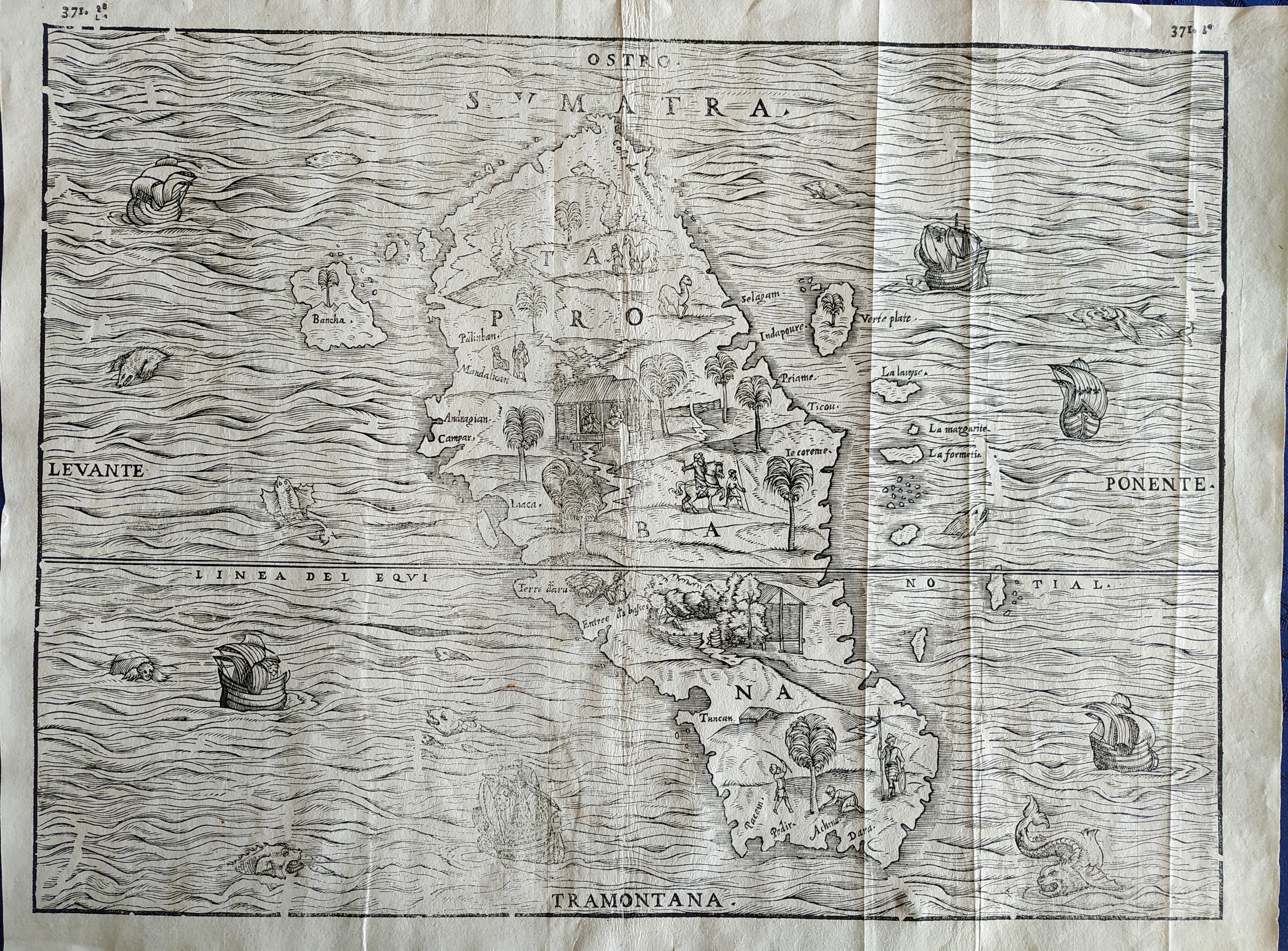
Map title
Sumatra
Author
Gastaldi
Location shown in map
Sumatra
Edition date
1606
Edition place
Venice
Editor
Giambattista Ramusio
Atlas
Delle navigazioni e viaggi
Price
Please ask: info@thetreasuremaps.com
State
[mint/excellent/VERY GOOD/good/fair/mediocre/poor]
Color
Black/white
Verso
pag.371
Size
Plate: cm (36 x 27) inches (14.17 x 10.63) Paper: cm (39 x 29) inches (15.35 x 11.42)
Technique
Woodcut
Note
Decorated with sea monsters and sailing ships.
Reference
--
Wiki
Here for more info
In stock
Available
Info
info@thetreasuremaps.com
Code
#0751
Sumatra
Author
Gastaldi
Location shown in map
Sumatra
Edition date
1606
Edition place
Venice
Editor
Giambattista Ramusio
Atlas
Delle navigazioni e viaggi
Price
Please ask: info@thetreasuremaps.com
State
[mint/excellent/VERY GOOD/good/fair/mediocre/poor]
Color
Black/white
Verso
pag.371
Size
Plate: cm (36 x 27) inches (14.17 x 10.63) Paper: cm (39 x 29) inches (15.35 x 11.42)
Technique
Woodcut
Note
Decorated with sea monsters and sailing ships.
Reference
--
Wiki
Here for more info
In stock
Available
Info
info@thetreasuremaps.com
Code
#0751
×
![Sumatra by Gastaldi, Sumatra, 1606]()
Map title
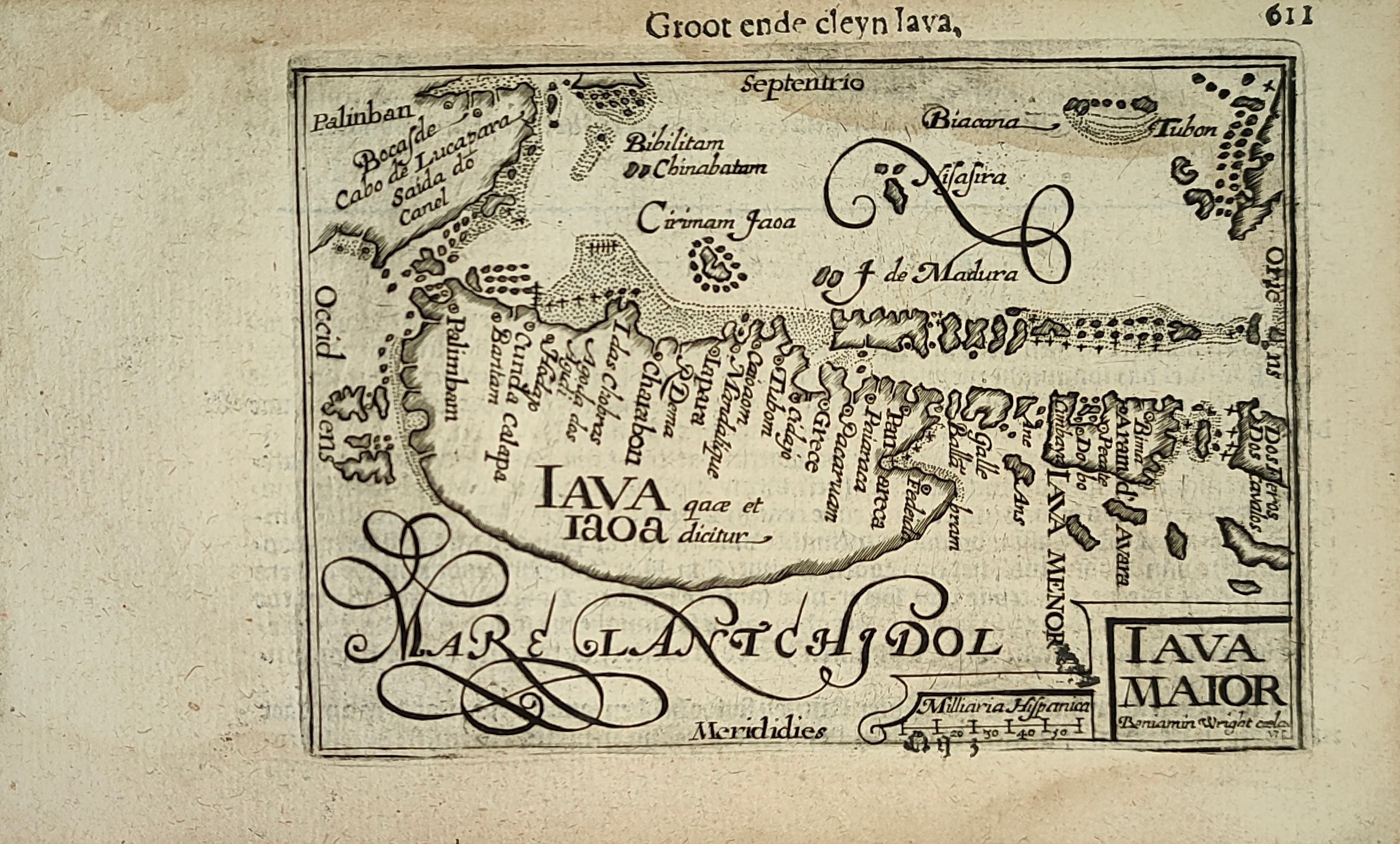
Groot ende cleyn Iava
Author
Bertius
Location shown in map
Java
Edition date
Circa 1606
Edition place
Amsterdam
Editor
Atlas
Price
300 Euro
State
[mint/EXCELLENT/very good/good/fair/mediocre/poor]
Color
Black/white
Verso
Duch text pag.612
Size
Plate: cm (12 x 9) inches (4.72 x 3.54) Paper: cm (18 x 11) inches (7.09 x 4.33)
Technique
Copper engraving
Note
Reference
Wiki
Here for more info
In stock
Available
Info
info@thetreasuremaps.com
Code
#1251
×
![Groot ende cleyn Iava by Bertius, Java, Circa 1606]()
Map title
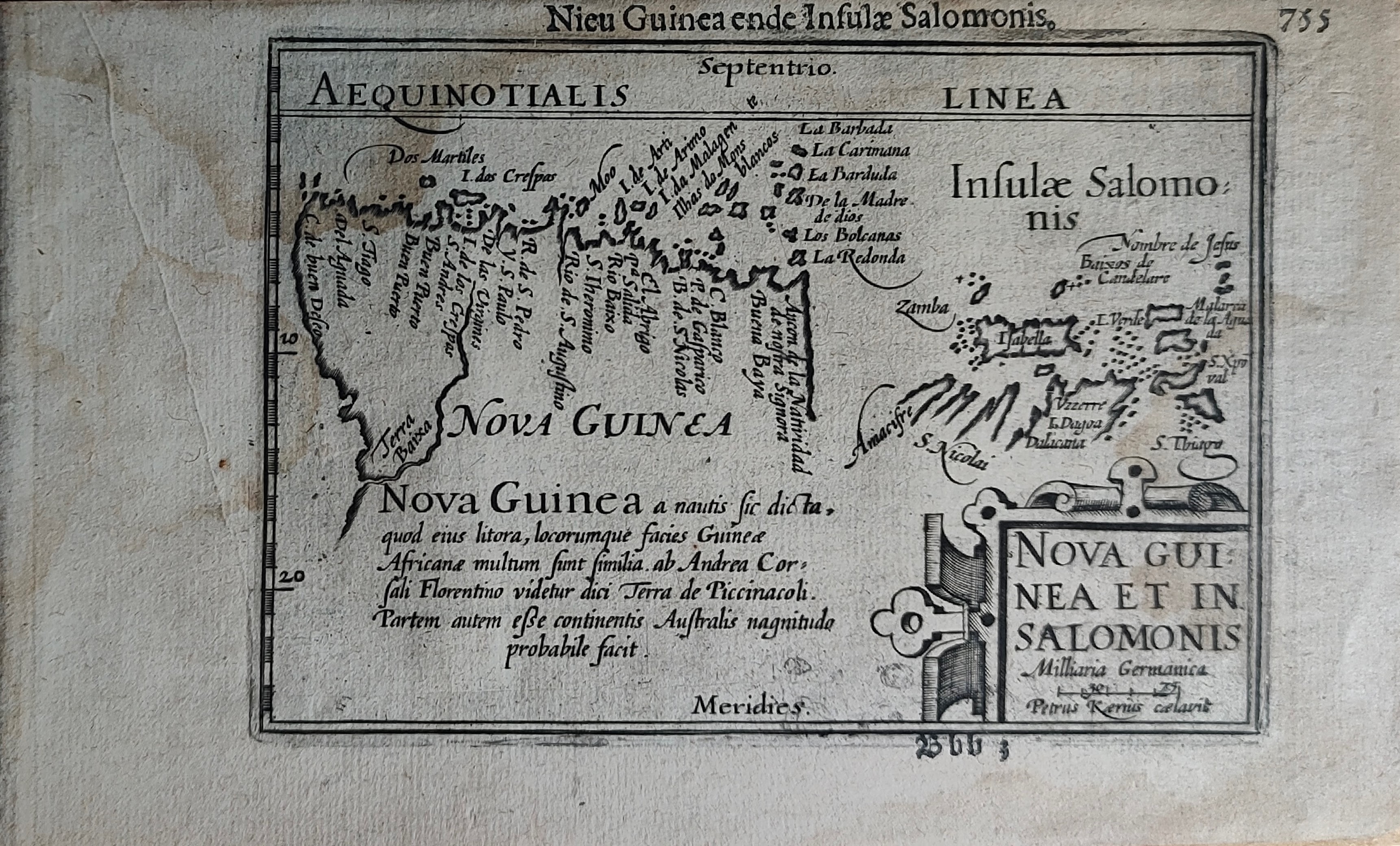
Nieu Guinea ende Insulae Salomonis
Author
Bertius
Location shown in map
New Guinea
Edition date
Circa 1606
Edition place
Amsterdam
Editor
Atlas
Price
300 Euro
State
[mint/EXCELLENT/very good/good/fair/mediocre/poor]
Color
Black/white
Verso
Duch text pag.756
Size
Plate: cm (12 x 9) inches (4.72 x 3.54) Paper: cm (18 x 11) inches (7.09 x 4.33)
Technique
Copper engraving
Note
Reference
Wiki
Here for more info
In stock
Available
Info
info@thetreasuremaps.com
Code
#1249
×
![Nieu Guinea ende Insulae Salomonis by Bertius, New Guinea, Circa 1606]()
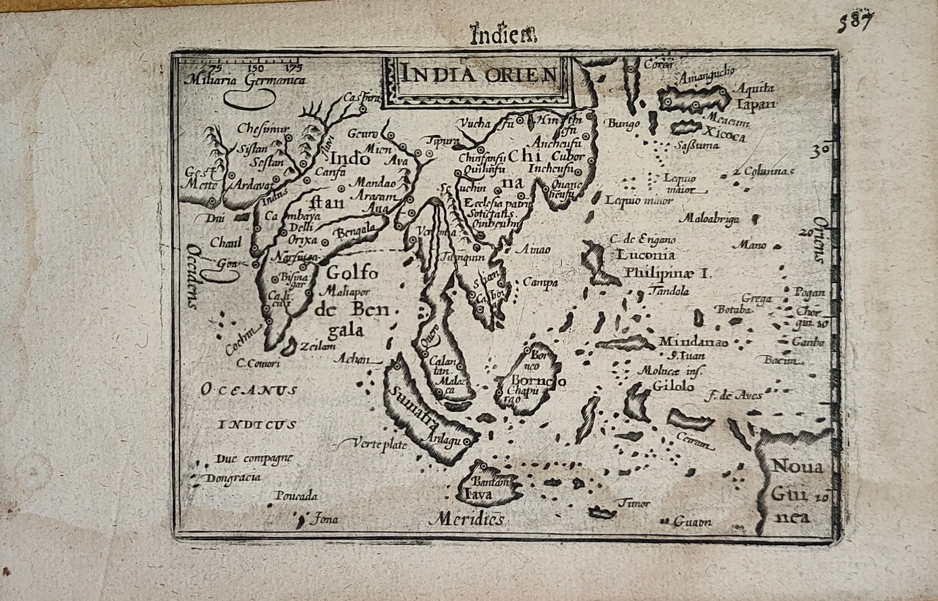
Map title
Indien
Author
Bertius
Location shown in map
South East
Edition date
Circa 1606
Edition place
Amsterdam
Editor
Atlas
Price
400 Euro
State
[mint/EXCELLENT/very good/good/fair/mediocre/poor]
Color
Black/white
Verso
Duch text pag.588
Size
Plate: cm (12 x 9) inches (4.72 x 3.54) Paper: cm (18 x 11) inches (7.09 x 4.33)
Technique
Copper engraving
Note
Reference
Wiki
Here for more info
In stock
Available
Info
info@thetreasuremaps.com
Code
#1252
×
![Indien by Bertius, South East, Circa 1606]()
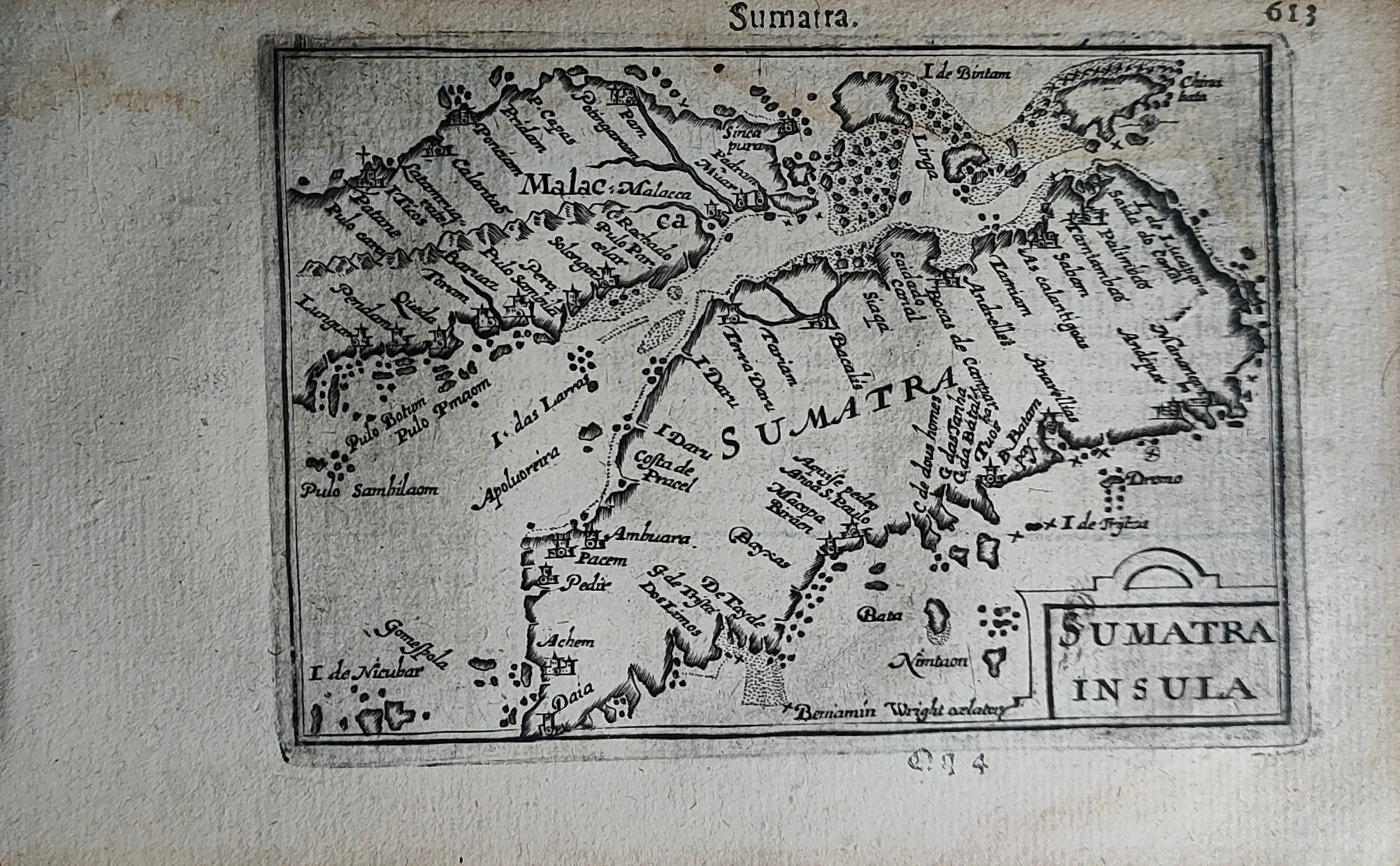
Map title
Sumatra
Author
Bertius
Location shown in map
Sumatra
Edition date
Circa 1606
Edition place
Amsterdam
Editor
Atlas
Price
300 Euro
State
[mint/EXCELLENT/very good/good/fair/mediocre/poor]
Color
Black/white
Verso
Duch text pag.614
Size
Plate: cm (12 x 9) inches (4.72 x 3.54) Paper: cm (18 x 11) inches (7.09 x 4.33)
Technique
Copper engraving
Note
Reference
Wiki
Here for more info
In stock
Available
Info
info@thetreasuremaps.com
Code
#1250
Sumatra
Author
Bertius
Location shown in map
Sumatra
Edition date
Circa 1606
Edition place
Amsterdam
Editor
Atlas
Price
300 Euro
State
[mint/EXCELLENT/very good/good/fair/mediocre/poor]
Color
Black/white
Verso
Duch text pag.614
Size
Plate: cm (12 x 9) inches (4.72 x 3.54) Paper: cm (18 x 11) inches (7.09 x 4.33)
Technique
Copper engraving
Note
Reference
Wiki
Here for more info
In stock
Available
Info
info@thetreasuremaps.com
Code
#1250
×
![Sumatra by Bertius, Sumatra, Circa 1606]()
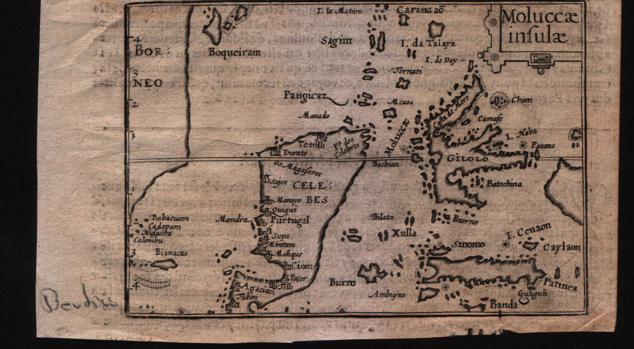
Map title
Moluccae insulae
Author
Bertius
Location shown in map
Moluccas
Edition date
Circa 1612
Edition place
Amsterdam
Editor
Jodocus Hondius
Atlas
Tabularum geographicarum contractarum
Price
Please ask: info@thetreasuremaps.com
State
[MINT/excellent/very good/good/fair/mediocre/poor]
Color
Black/white
Verso
French text pag 58
Size
Plate: cm (12.7 x 8.9) inches (5 x 3.5) Paper: cm (16.5 x 10.2) inches (6.5 x 4.02)
Technique
Copper engraving
Note
--
Reference
--
Wiki
Here for more info
In stock
Available
Info
info@thetreasuremaps.com
Code
#0596
×
![Moluccae insulae by Bertius, Moluccas, Circa 1612]()