South East
Map title
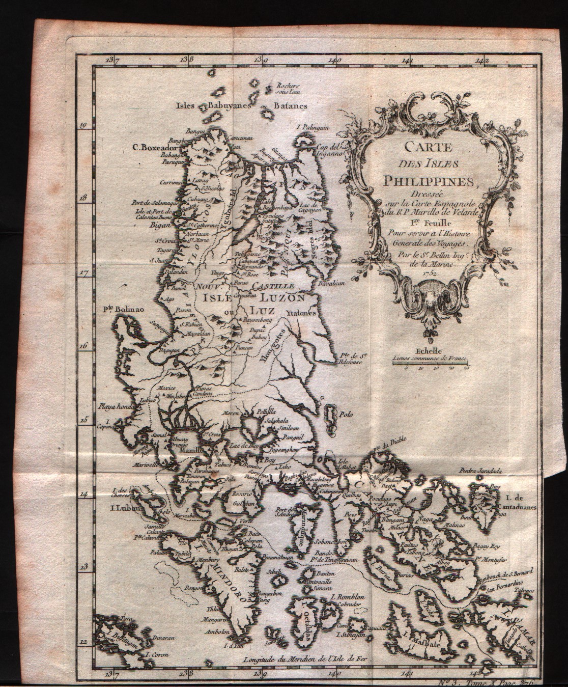
Carte des Isles Philippines 1Feuille
Author
Bellin
Location shown in map
Philippines
Edition date
1757
Edition place
Paris
Editor
--
Atlas
Historie General des Voyages -- Prevost
Price
200 Euro
State
[mint/EXCELLENT/very good/good/fair/mediocre/poor]
Color
Black/white
Verso
Blank
Size
Plate: cm (15.2 x 20.3) inches (5.98 x 7.99) Paper: cm (17.8 x 21.6) inches (7.01 x 8.5)
Technique
Copper engraving
Note
No particular notes for this maps
Reference
--
Wiki
Here for more info
In stock
Available
Info
info@thetreasuremaps.com
Code
#0234
×
![Carte des Isles Philippines 1Feuille by Bellin, Philippines , 1757]()
Map title
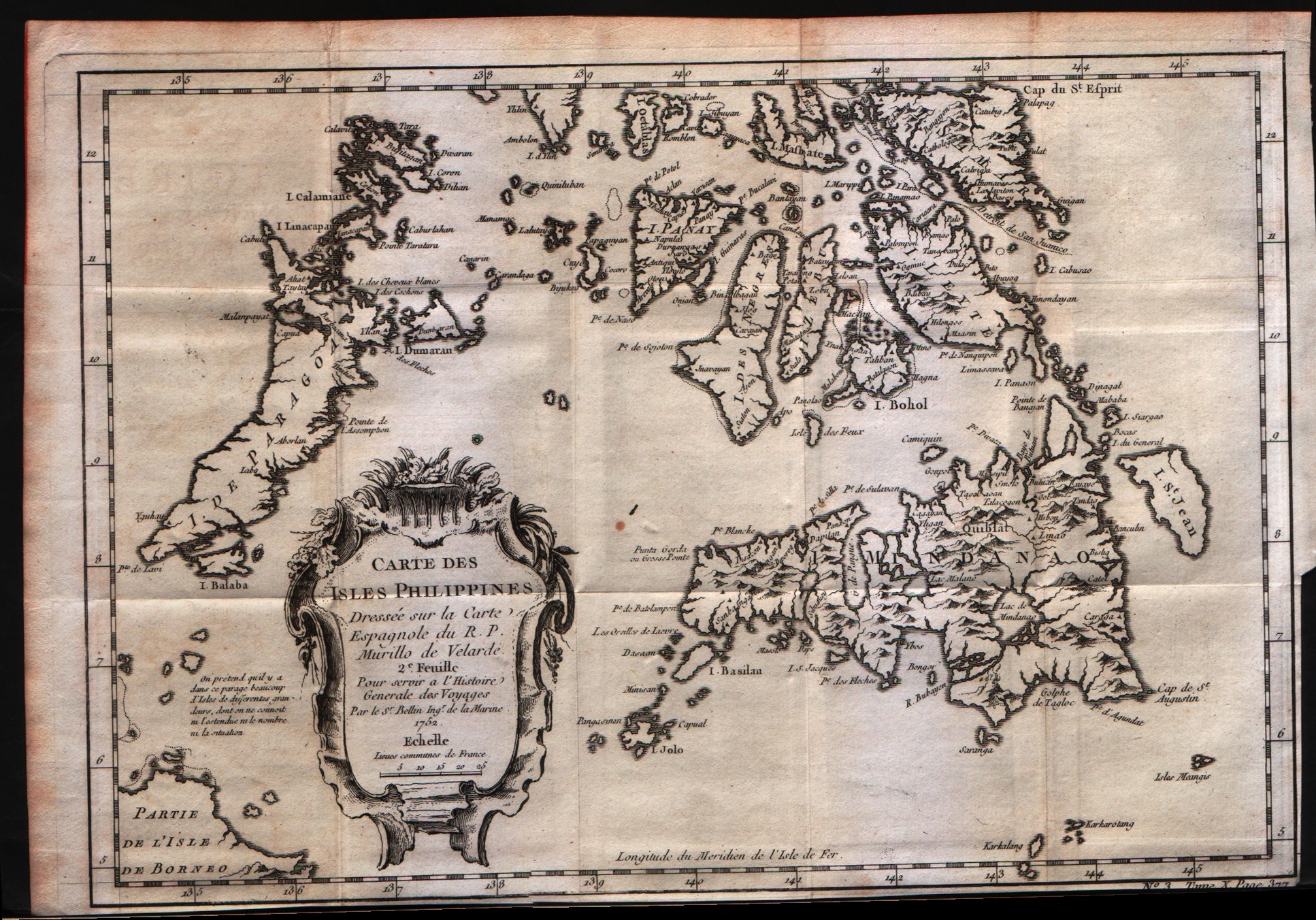
Carte des Isles Philippines 2Feuille
Author
Bellin
Location shown in map
Philippines
Edition date
1757
Edition place
Paris
Editor
--
Atlas
Historie General des Voyages -- Prevost
Price
200 Euro
State
[mint/EXCELLENT/very good/good/fair/mediocre/poor]
Color
Black/white
Verso
Blank
Size
Plate: cm (30.5 x 20.3) inches (12.01 x 7.99) Paper: cm (31.8 x 22.9) inches (12.52 x 9.02)
Technique
Copper engraving
Note
No particular notes for this maps
Reference
--
Wiki
Here for more info
In stock
Available
Info
info@thetreasuremaps.com
Code
#0235
×
![Carte des Isles Philippines 2Feuille by Bellin, Philippines , 1757]()
Map title
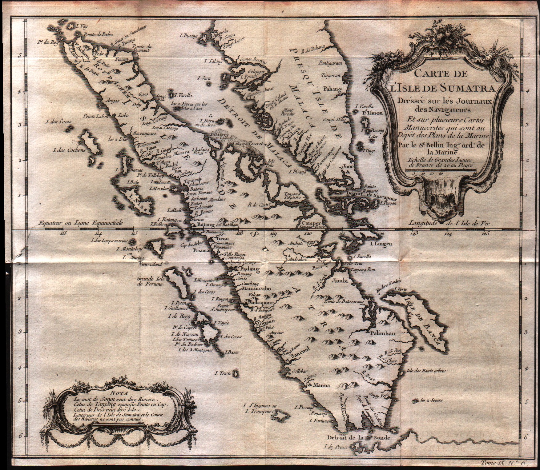
Carte De L'Isle de Sumatra
Author
Bellin
Location shown in map
--
Edition date
1757
Edition place
Paris
Editor
--
Atlas
Historie General des Voyages -- Prevost
Price
Please ask: info@thetreasuremaps.com
State
[mint/excellent/VERY GOOD/good/fair/mediocre/poor]
Color
Black/white
Verso
Blank
Size
Plate: cm (29.2 x 26.7) inches (11.5 x 10.51) Paper: cm (29.2 x 26) inches (11.5 x 10.24)
Technique
Copper engraving
Note
No particular notes for this maps
Reference
--
Wiki
Here for more info
In stock
Available
Info
info@thetreasuremaps.com
Code
#0241
×
![Carte De L'Isle de Sumatra by Bellin, --, 1757]()
Map title
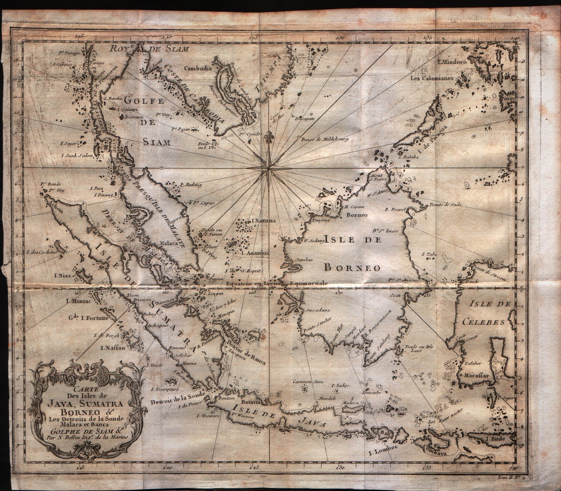
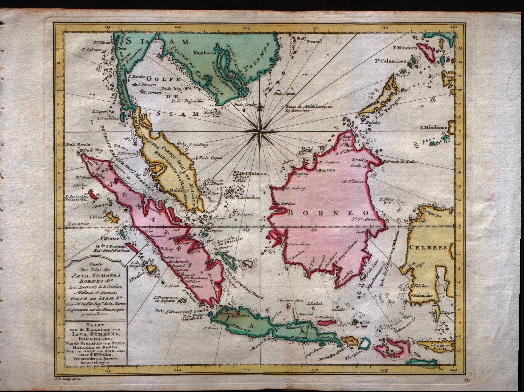
Carte Des Isles De Java, Sumatra Borneo
Author
Bellin
Location shown in map
Java Sumatra
Edition date
1757
Edition place
Paris
Editor
--
Atlas
Historie General des Voyages -- Prevost
Price
200 Euro
State
[mint/excellent/VERY GOOD/good/fair/mediocre/poor]
Color
Black/white
Verso
Blank
Size
Plate: cm (29.2 x 24.1) inches (11.5 x 9.49) Paper: cm (30.5 x 26.7) inches (12.01 x 10.51)
Technique
Copper engraving
Note
No particular notes for this maps
Reference
--
Wiki
Here for more info
In stock
Available
Info
info@thetreasuremaps.com
Code
#0247
×
![Carte Des Isles De Java, Sumatra Borneo by Bellin, Java Sumatra, 1757]()
Map title
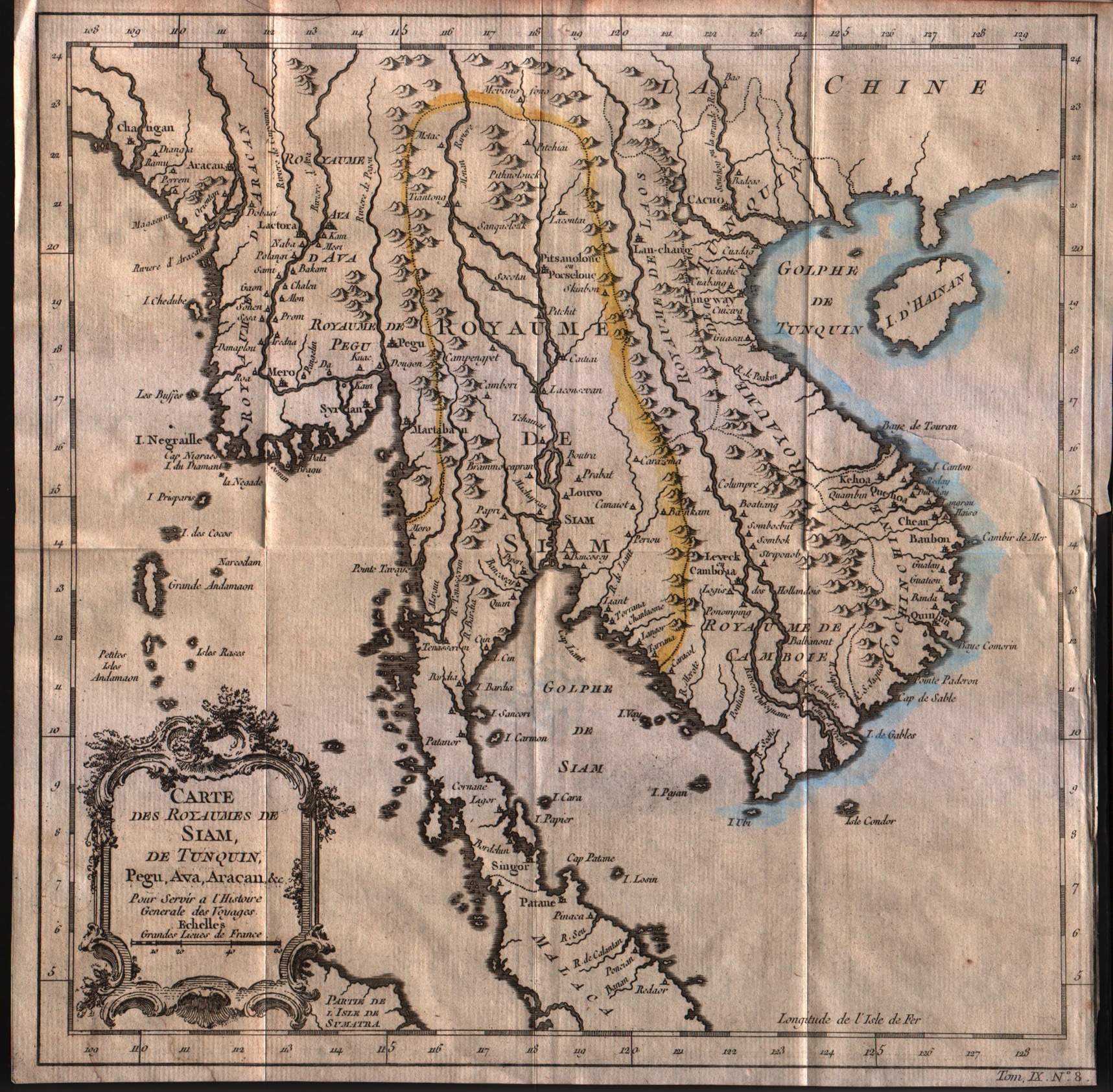
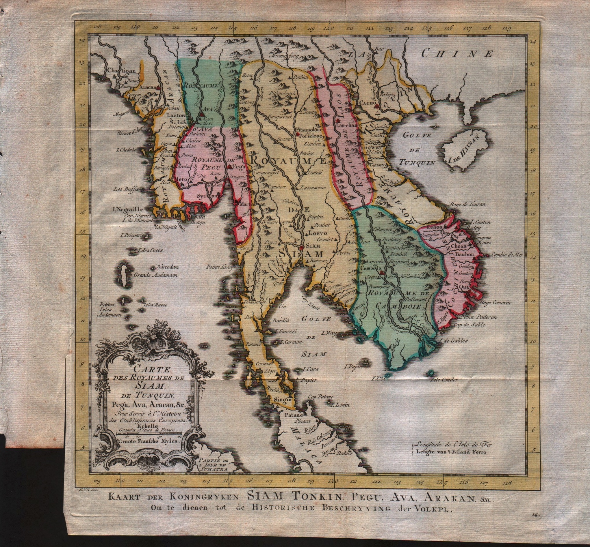
Carte des royaumes de Siam de Tunquin, Pegu, Ava, Aracan
Author
Bellin
Location shown in map
--
Edition date
1757
Edition place
Paris
Editor
--
Atlas
Historie General des Voyages -- Prevost
Price
Please ask: info@thetreasuremaps.com
State
[mint/excellent/very good/GOOD/fair/mediocre/poor]
Color
Black/white
Verso
Blank
Size
Plate: cm (27.9 x 27.9) inches (10.98 x 10.98) Paper: cm (28.6 x 28.6) inches (11.26 x 11.26)
Technique
Copper engraving
Note
No particular notes for this maps
Reference
--
Wiki
Here for more info
In stock
Available
Info
info@thetreasuremaps.com
Code
#0250
×
![Carte des royaumes de Siam de Tunquin, Pegu, Ava, Aracan by Bellin, --, 1757]()
Map title
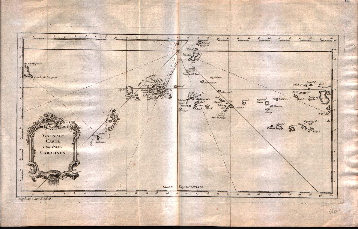
Nouvelle carte des isles Carolines
Author
Bellin
Location shown in map
Caroline islands
Edition date
1757
Edition place
Paris
Editor
--
Atlas
Historie General des Voyages -- Prevost
Price
125 Euro
State
[mint/EXCELLENT/very good/good/fair/mediocre/poor]
Color
Black/white
Verso
Blank
Size
Plate: cm (38.1 x 20.3) inches (15 x 7.99) Paper: cm (43.2 x 27.9) inches (17.01 x 10.98)
Technique
Copper engraving
Note
No particular notes for this maps
Reference
--
Wiki
Here for more info
In stock
Available
Info
info@thetreasuremaps.com
Code
#0251
×
![Nouvelle carte des isles Carolines by Bellin, Caroline islands, 1757]()

Map title
Suite De L'Ocean Oriental contenant les isles del la Sonde les costes de Tunquin et de la Chine les isles du Japon les Philippines Moluques.
Author
Bellin
Location shown in map
--
Edition date
1757
Edition place
Paris
Editor
--
Atlas
Historie General des Voyages -- Prevost
Price
Please ask: info@thetreasuremaps.com
State
[mint/excellent/VERY GOOD/good/fair/mediocre/poor]
Color
Black/white
Verso
Blank
Size
Plate: cm (29.8 x 29.2) inches (11.73 x 11.5) Paper: cm (33.7 x 32.4) inches (13.27 x 12.76)
Technique
Copper engraving
Note
Note the unusual outlines of Japan and Korea. And the not well known Nouvelle Guinee
Reference
--
Wiki
Here for more info
In stock
Sold
Info
info@thetreasuremaps.com
Code
#0452
×
![Suite De L'Ocean Oriental contenant les isles del la Sonde les costes de Tunquin et de la Chine les isles du Japon les Philippines Moluques. by Bellin, --, 1757]()
Map title
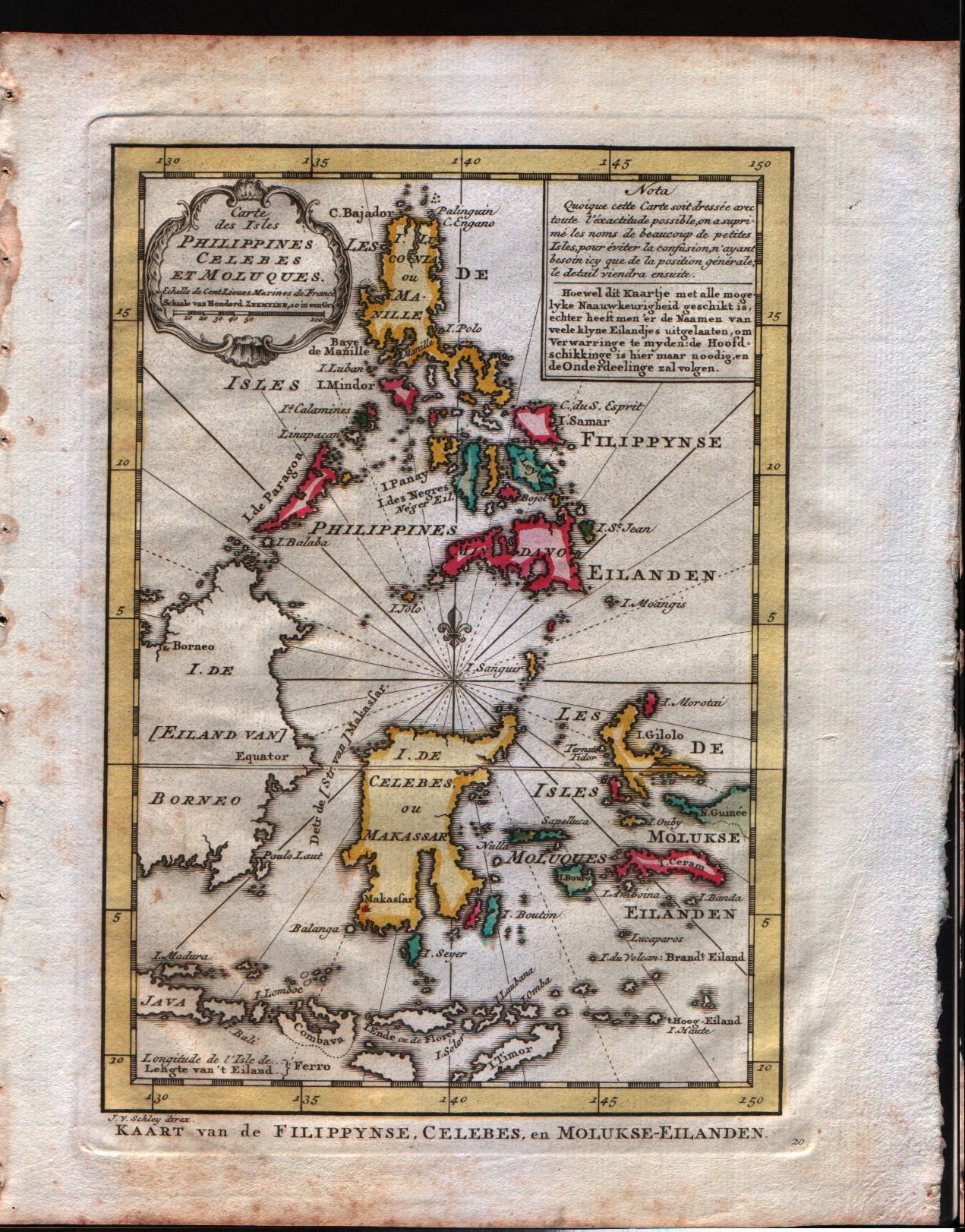
Carte des Isles Philippines Celebes et Moluques
Author
Bellin
Location shown in map
Philippines
Edition date
1773
Edition place
Amsterdam
Editor
--
Atlas
Atlas Portatif -- E. van Harrevelt
Price
200 Euro
State
[mint/EXCELLENT/very good/good/fair/mediocre/poor]
Color
Old outlined
Verso
Blank
Size
Plate: cm (15.2 x 21.6) inches (5.98 x 8.5) Paper: cm (21.6 x 26.7) inches (8.5 x 10.51)
Technique
Copper engraving
Note
No particular notes for this maps
Reference
--
Wiki
Here for more info
In stock
Available
Info
info@thetreasuremaps.com
Code
#0259
×
![Carte des Isles Philippines Celebes et Moluques by Bellin, Philippines , 1773]()
Map title
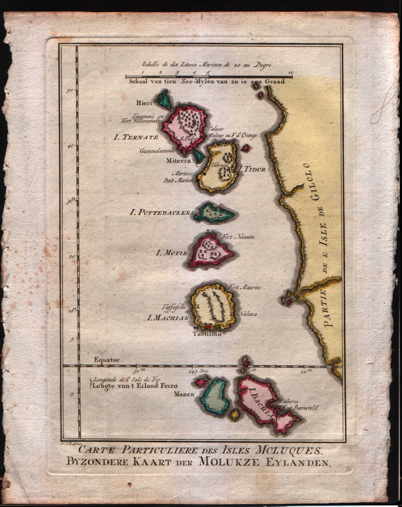
Carte particulier des Isles Moluques
Author
Bellin
Location shown in map
--
Edition date
1773
Edition place
Amsterdam
Editor
--
Atlas
Atlas Portatif -- E. van Harrevelt
Price
Please ask: info@thetreasuremaps.com
State
[mint/EXCELLENT/very good/good/fair/mediocre/poor]
Color
Old colors
Verso
Blank
Size
Plate: cm (15.2 x 21.6) inches (5.98 x 8.5) Paper: cm (21.6 x 26.7) inches (8.5 x 10.51)
Technique
Copper engraving
Note
No particular notes for this maps
Reference
--
Wiki
Here for more info
In stock
Available
Info
info@thetreasuremaps.com
Code
#0260
×
![Carte particulier des Isles Moluques by Bellin, --, 1773]()
Map title
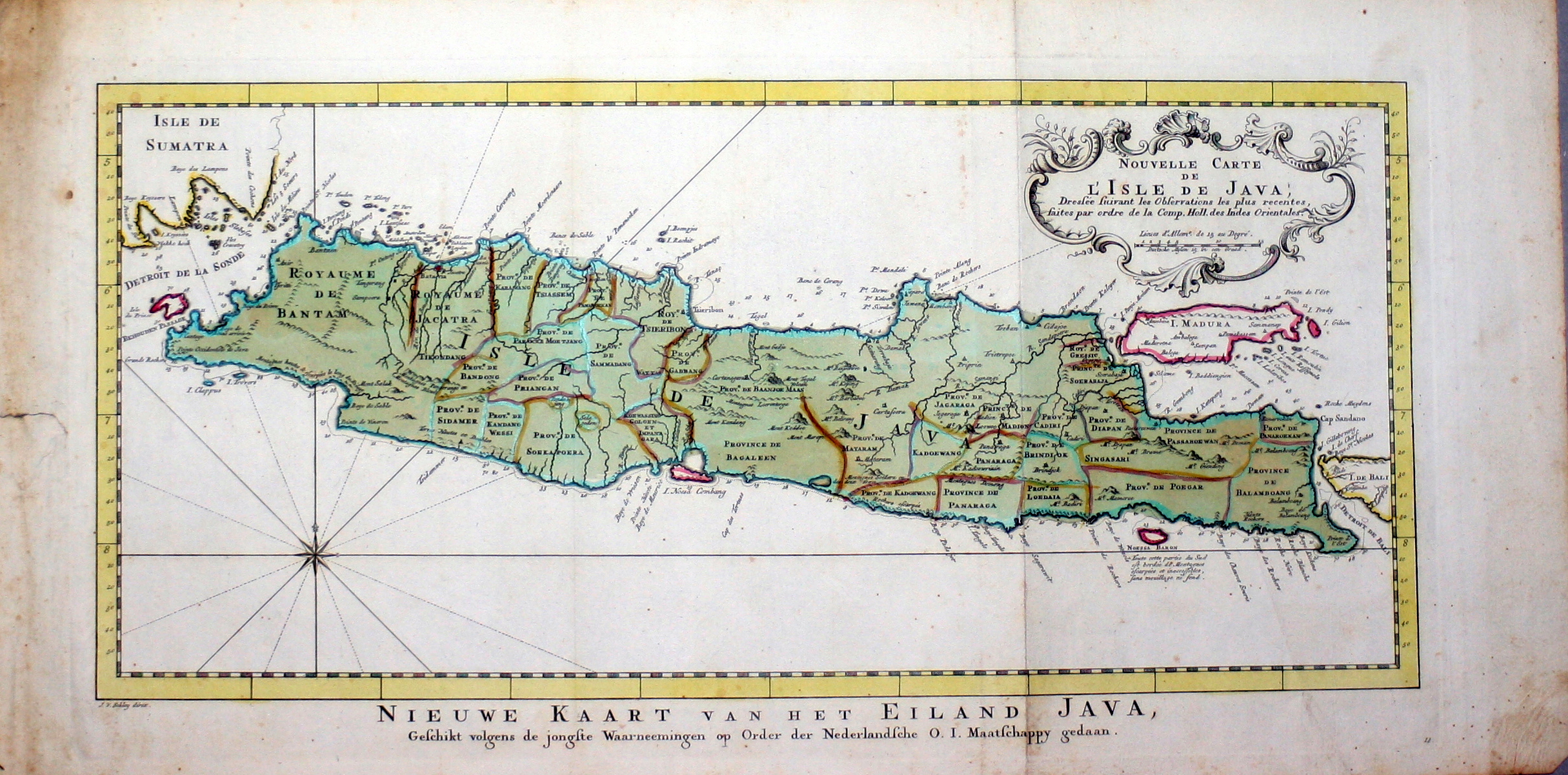
Nouvelle carte de l'isle de Java
Author
Unknown
Location shown in map
--
Edition date
1773
Edition place
Amsterdam
Editor
--
Atlas
Atlas Portatif -- E. van Harrevelt
Price
Please ask: info@thetreasuremaps.com
State
[mint/EXCELLENT/very good/good/fair/mediocre/poor]
Color
Old colors
Verso
Blank
Size
Plate: cm (43.2 x 20.3) inches (17.01 x 7.99) Paper: cm (53.3 x 26.7) inches (20.98 x 10.51)
Technique
Copper engraving
Note
No particular notes for this maps
Reference
--
Wiki
Here for more info
In stock
Available
Info
info@thetreasuremaps.com
Code
#0262
×
![Nouvelle carte de l'isle de Java by Unknown, --, 1773]()
Map title
Carte des royaumes de Siam de Tunquin, Pegu, Ava, Aracan
Author
Bellin
Location shown in map
--
Edition date
1773
Edition place
Amsterdam
Editor
--
Atlas
Atlas Portatif -- E. van Harrevelt
Price
250 Euro
State
[mint/EXCELLENT/very good/good/fair/mediocre/poor]
Color
Old colors
Verso
Blank
Size
Plate: cm (27.9 x 27.9) inches (10.98 x 10.98) Paper: cm (35.6 x 31.8) inches (14.02 x 12.52)
Technique
Copper engraving
Note
No particular notes for this maps
Reference
--
Wiki
Here for more info
In stock
Available
Info
info@thetreasuremaps.com
Code
#0263
×
![Carte des royaumes de Siam de Tunquin, Pegu, Ava, Aracan by Bellin, --, 1773]()
Map title
Carte Des Isles de Java, Sumatra, Borneo
Author
Bellin
Location shown in map
Java Sumatra
Edition date
1773
Edition place
Amsterdam
Editor
--
Atlas
Atlas Portatif -- E. van Harrevelt
Price
200 Euro
State
[mint/EXCELLENT/very good/good/fair/mediocre/poor]
Color
Old colors
Verso
Blank
Size
Plate: cm (29.2 x 24.1) inches (11.5 x 9.49) Paper: cm (35.6 x 26.7) inches (14.02 x 10.51)
Technique
Copper engraving
Note
No particular notes for this maps
Reference
--
Wiki
Here for more info
In stock
Available
Info
info@thetreasuremaps.com
Code
#0267
×
![Carte Des Isles de Java, Sumatra, Borneo by Bellin, Java Sumatra, 1773]()
Map title
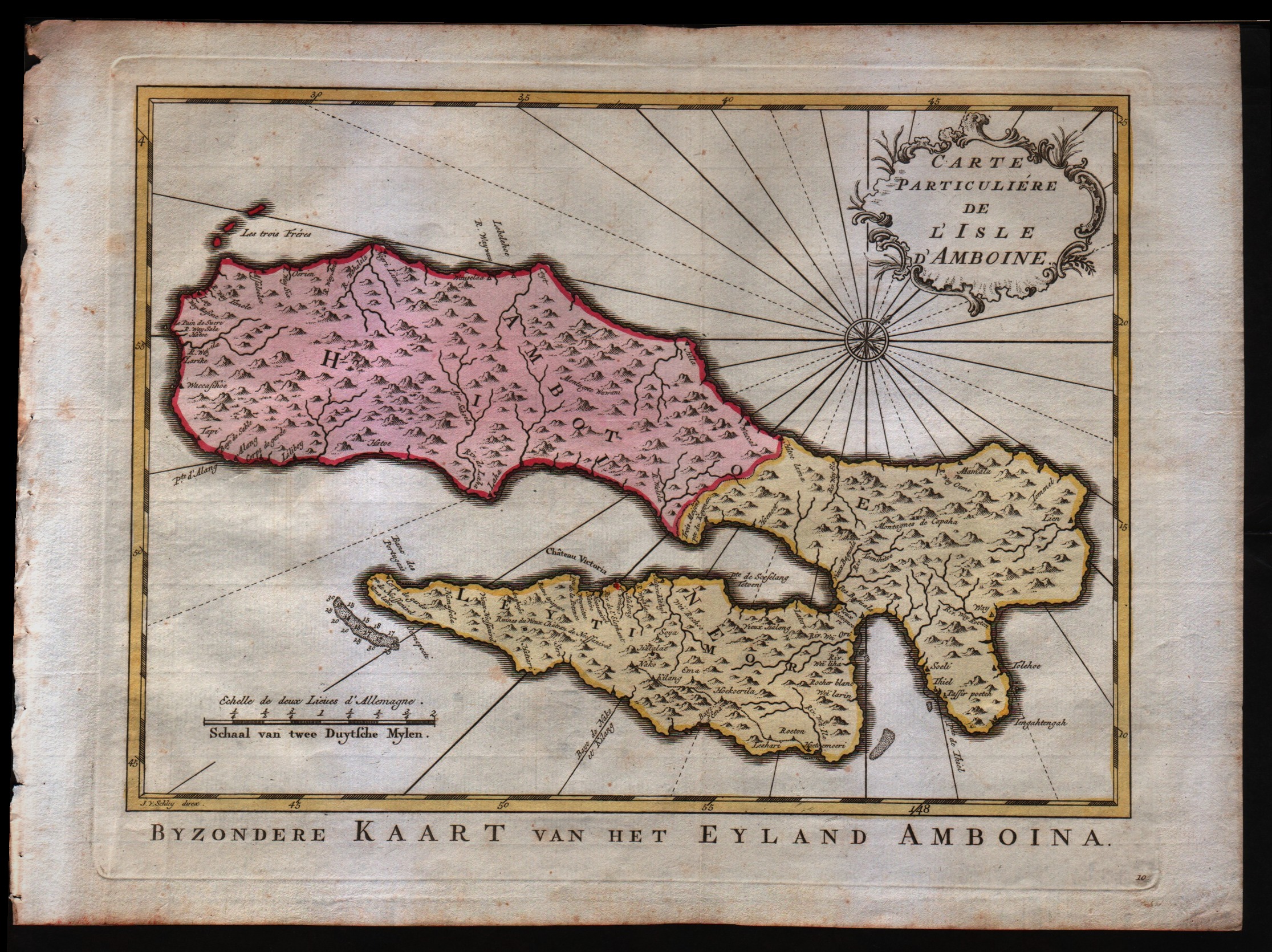
Carte particulier de l'isle d'Amboine
Author
Bellin
Location shown in map
--
Edition date
1773
Edition place
Amsterdam
Editor
--
Atlas
Atlas Portatif -- E. van Harrevelt
Price
Please ask: info@thetreasuremaps.com
State
[mint/EXCELLENT/very good/good/fair/mediocre/poor]
Color
Old colors
Verso
Blank
Size
Plate: cm (29.2 x 21.6) inches (11.5 x 8.5) Paper: cm (35.6 x 26.7) inches (14.02 x 10.51)
Technique
Copper engraving
Note
No particular notes for this maps
Reference
--
Wiki
Here for more info
In stock
Available
Info
info@thetreasuremaps.com
Code
#0268
×
![Carte particulier de l'isle d'Amboine by Bellin, --, 1773]()
Map title
Carte des environs de Batavia
Author
Bellin
Location shown in map
Batavia city
Edition date
1773
Edition place
Amsterdam
Editor
--
Atlas
Atlas Portatif -- E. van Harrevelt
Price
Please ask: info@thetreasuremaps.com
State
[mint/EXCELLENT/very good/good/fair/mediocre/poor]
Color
Old colors
Verso
Blank
Size
Plate: cm (27.9 x 22.9) inches (10.98 x 9.02) Paper: cm (35.6 x 25.4) inches (14.02 x 10)
Technique
Copper engraving
Note
No particular notes for this maps
Reference
--
Wiki
Here for more info
In stock
Sold
Info
info@thetreasuremaps.com
Code
#0275
×
![Carte des environs de Batavia by Bellin, Batavia city, 1773]()