West Indies
Pages: 1 2
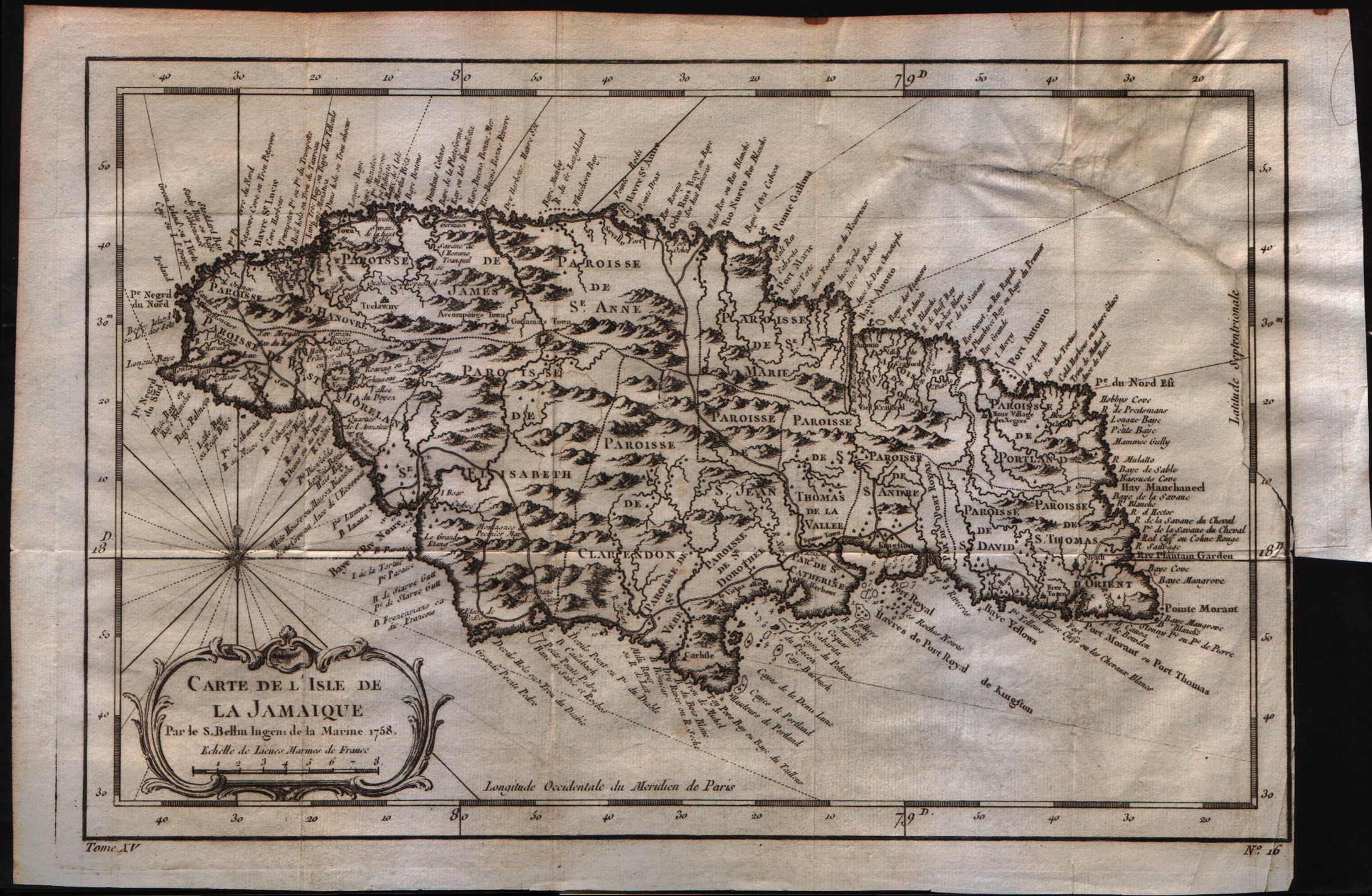
Map title
Carte de lisle de la Jamaique
Author
Bellin
Location shown in map
Jamaica
Edition date
1757
Edition place
Paris
Editor
--
Atlas
Historie General des Voyages -- Prevost
Price
150 Euro
State
[mint/excellent/very good/good/fair/MEDIOCRE/poor]
Color
Black/white
Verso
Blank
Size
Plate: cm (15.2 x 20.3) inches (5.98 x 7.99) Paper: cm (30.5 x 20.3) inches (12.01 x 7.99)
Technique
Copper engraving
Note
No particular notes for this maps
Reference
--
Wiki
Here for more info
In stock
Available
Info
info@thetreasuremaps.com
Code
#0349
×
![Carte de lisle de la Jamaique by Bellin, Jamaica, 1757]()
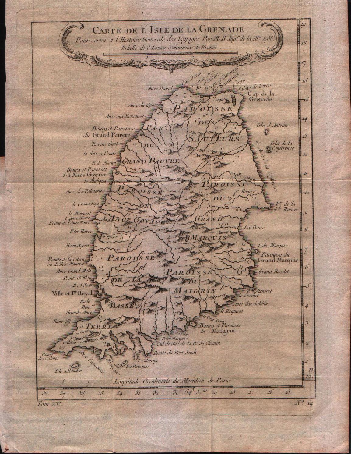
Map title
Carte de l'isle de la Grenade
Author
Bellin
Location shown in map
Grenada
Edition date
1757
Edition place
Paris
Editor
--
Atlas
Historie General des Voyages -- Prevost
Price
150 Euro
State
[mint/EXCELLENT/very good/good/fair/mediocre/poor]
Color
Black/white
Verso
Blank
Size
Plate: cm (15.2 x 21.6) inches (5.98 x 8.5) Paper: cm (20.3 x 25.4) inches (7.99 x 10)
Technique
Copper engraving
Note
No particular notes for this maps
Reference
--
Wiki
Here for more info
In stock
Available
Info
info@thetreasuremaps.com
Code
#0353
×
![Carte de l'isle de la Grenade by Bellin, Grenada, 1757]()
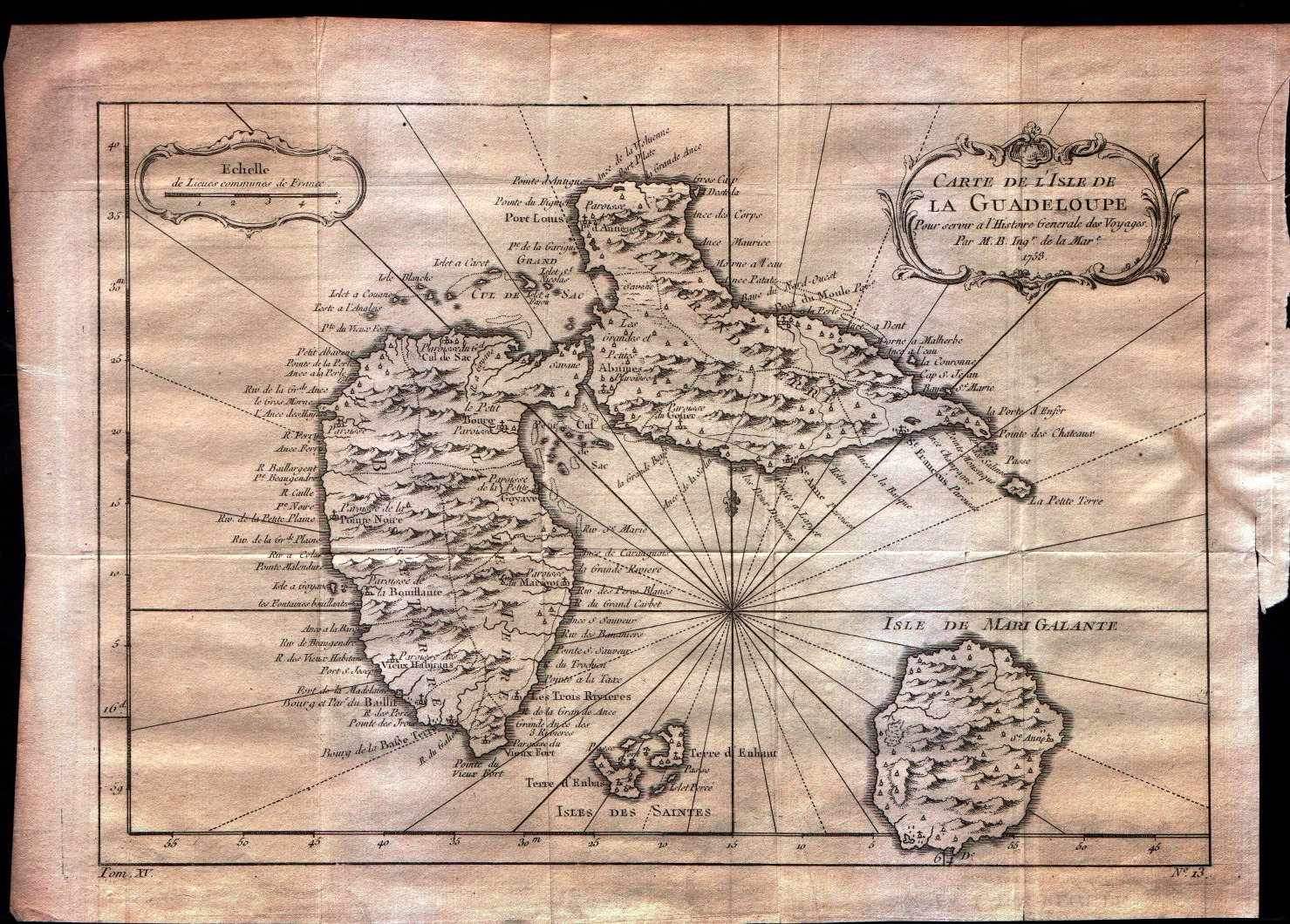
Map title
Carte de l'isle de la Guadeloupe
Author
Bellin
Location shown in map
Guadeloupe
Edition date
1757
Edition place
Paris
Editor
--
Atlas
Historie General des Voyages -- Prevost
Price
150 Euro
State
[mint/EXCELLENT/very good/good/fair/mediocre/poor]
Color
Black/white
Verso
Blank
Size
Plate: cm (30.5 x 21.6) inches (12.01 x 8.5) Paper: cm (34.3 x 25.4) inches (13.5 x 10)
Technique
Copper engraving
Note
No particular notes for this maps
Reference
--
Wiki
Here for more info
In stock
Available
Info
info@thetreasuremaps.com
Code
#0354
×
![Carte de l'isle de la Guadeloupe by Bellin, Guadeloupe, 1757]()
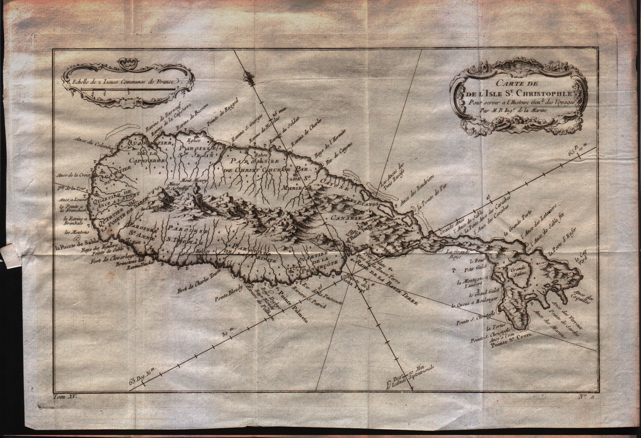
Map title
Carte de l'isle St.Christophle
Author
Bellin
Location shown in map
St.Christopher
Edition date
1757
Edition place
Paris
Editor
--
Atlas
Historie General des Voyages -- Prevost
Price
150 Euro
State
[mint/EXCELLENT/very good/good/fair/mediocre/poor]
Color
Black/white
Verso
Blank
Size
Plate: cm (30.5 x 20.3) inches (12.01 x 7.99) Paper: cm (34.3 x 24.1) inches (13.5 x 9.49)
Technique
Copper engraving
Note
No particular notes for this maps
Reference
--
Wiki
Here for more info
In stock
Available
Info
info@thetreasuremaps.com
Code
#0355
×
![Carte de l'isle St.Christophle by Bellin, St.Christopher, 1757]()
Map title
Carte de l'isle de Saint Domingue
Author
Bellin
Location shown in map
Haiti
Edition date
1757
Edition place
Paris
Editor
--
Atlas
Historie General des Voyages -- Prevost
Price
150 Euro
State
[mint/EXCELLENT/very good/good/fair/mediocre/poor]
Color
Black/white
Verso
Blank
Size
Plate: cm (27.9 x 20.3) inches (10.98 x 7.99) Paper: cm (33 x 25.4) inches (12.99 x 10)
Technique
Copper engraving
Note
No particular notes for this maps
Reference
--
Wiki
Here for more info
In stock
Available
Info
info@thetreasuremaps.com
Code
#0356
×
![Carte de l'isle de Saint Domingue by Bellin, Haiti, 1757]()
Map title
Carta dell'isola di Santa Lucia
Author
Bellin
Location shown in map
Sant Lucia
Edition date
1760
Edition place
Paris
Editor
--
Atlas
Historie General des Voyages -- Prevost
Price
150 Euro
State
[mint/EXCELLENT/very good/good/fair/mediocre/poor]
Color
Black/white
Verso
Blank
Size
Plate: cm (30 x 20) inches (11.81 x 7.87) Paper: cm (33 x 23) inches (12.99 x 9.06)
Technique
Copper engraving
Note
Reference
--
Wiki
Here for more info
In stock
Available
Info
info@thetreasuremaps.com
Code
#1172
×
![Carta dell'isola di Santa Lucia by Bellin, Sant Lucia, 1760]()
Map title
Carte du Golphe du Mexique et des Isles de l'Amerique
Author
Bellin
Location shown in map
--
Edition date
1773
Edition place
Amsterdam
Editor
--
Atlas
Atlas Portatif -- E. van Harrevelt
Price
275 Euro
State
[mint/EXCELLENT/very good/good/fair/mediocre/poor]
Color
Old colors
Verso
Blank
Size
Plate: cm (36.8 x 26.7) inches (14.49 x 10.51) Paper: cm (39.4 x 31.8) inches (15.51 x 12.52)
Technique
Copper engraving
Note
No particular notes for this maps
Reference
--
Wiki
Here for more info
In stock
Available
Info
info@thetreasuremaps.com
Code
#0071
×
![Carte du Golphe du Mexique et des Isles de l'Amerique by Bellin, --, 1773]()
Map title
Carte Geo-Hydrographique du golfe du Mexico
Author
Rizzi Zannoni
Location shown in map
West Indies
Edition date
Circa 1780
Edition place
Paris
Editor
Atlas
Price
300 Euro
State
[mint/EXCELLENT/very good/good/fair/mediocre/poor]
Color
Old colors
Verso
Blank
Size
Plate: cm (45 x 31) inches (17.72 x 12.2) Paper: cm (54 x 39) inches (21.26 x 15.35)
Technique
Copper engraving
Note
Reference
Wiki
Here for more info
In stock
Available
Info
info@thetreasuremaps.com
Code
#1263
×
![Carte Geo-Hydrographique du golfe du Mexico by Rizzi Zannoni, West Indies, Circa 1780]()

Map title
Les Isle Antilles Et Le Golfe Du Mexique
Author
Bonne
Location shown in map
--
Edition date
1787
Edition place
Paris
Editor
--
Atlas
Atlas Encyclopedique
Price
Please ask: info@thetreasuremaps.com
State
[mint/excellent/very good/GOOD/fair/mediocre/poor]
Color
Modern outlined
Verso
Blank
Size
Plate: cm (31.8 x 21) inches (12.52 x 8.27) Paper: cm (36.8 x 25.4) inches (14.49 x 10)
Technique
Copper engraving
Note
No particular notes for this maps
Reference
--
Wiki
Here for more info
In stock
Sold
Info
info@thetreasuremaps.com
Code
#0395
×
![Les Isle Antilles Et Le Golfe Du Mexique by Bonne, --, 1787]()
Map title
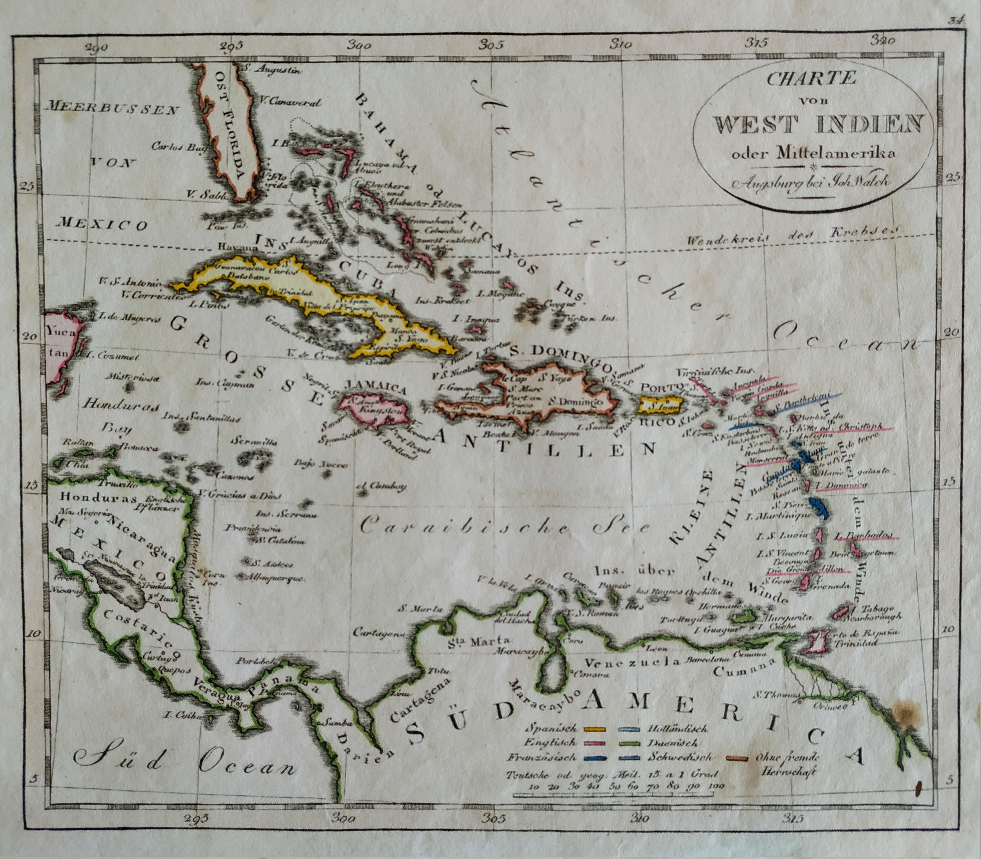
Charte von west Indien
Author
Johann Walch
Location shown in map
West Indies
Edition date
1820
Edition place
Hamburg
Editor
Atlas
Price
Please ask: info@thetreasuremaps.com
State
[mint/EXCELLENT/very good/good/fair/mediocre/poor]
Color
Old colors
Verso
Blank
Size
Plate: cm (21 x 18) inches (8.27 x 7.09) Paper: cm (26 x 22) inches (10.24 x 8.66)
Technique
Steel engraving
Note
No particular notes for this maps
Reference
Wiki
Here for more info
In stock
Available
Info
info@thetreasuremaps.com
Code
#0700
×
![Charte von west Indien by Johann Walch, West Indies, 1820]()
Pages: 1 2